- National Register of Historic Places listings in Big Horn County, Montana
-
 Location of Big Horn County in Montana
This is a list of the National Register of Historic Places listings in Big Horn County, Montana. It is intended to be a complete list of the properties and districts on the National Register of Historic Places in Big Horn County, Montana, United States. The locations of National Register properties and districts for which the latitude and longitude coordinates are included below, may be seen in a Google map.[1]
There are 39 properties and districts listed on the National Register in the county, including 2 National Historic Landmarks.
-
- This National Park Service list is complete through NPS recent listings posted November 10, 2011.[2]
Listings county-wide
[3] Landmark name Image Date listed Location City or town Summary 1 Annashisee Iisaxpuatahcheeaashisee-Medicine Wheel on Bighorn River March 25, 1999 Address Restricted Fort Smith 2 Baldwin House August 3, 1987 25 3rd Ave.
45°19′02″N 107°22′00″W / 45.317222°N 107.366667°WLodge Grass 3 Bighorn Ditch Headgate 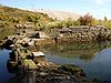
December 12, 1976 West of Fort Smith at the mouth of Bighorn Canyon
45°18′56″N 107°57′03″W / 45.315556°N 107.950833°WFort Smith 4 John Boyum House April 11, 1991 225 W. 6th St.
45°44′05″N 107°36′35″W / 45.734722°N 107.609722°WHardin 5 Thomas H. Burke House April 11, 1991 604 N. Cody
45°44′04″N 107°36′36″W / 45.734444°N 107.61°WHardin 6 Cammock's Hotel August 30, 1987 28 N. Main St.
45°18′57″N 107°21′49″W / 45.315833°N 107.363611°WLodge Grass 7 Camp Four January 21, 1992 11 miles northeast of Fort Smith on Fort Smith-Hardin County Road
45°24′50″N 107°53′43″W / 45.413889°N 107.895278°WFort Smith 8 Chief Plenty Coups (Alek-Chea-Ahoosh) House 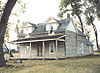
October 6, 1970 1 mile west of Pryor off Montana Highway 416
45°25′44″N 108°32′45″W / 45.428889°N 108.545833°WPryor 9 Chivers Memorial Church August 3, 1987 East of the former CB&Q railroad tracks, along the western side of U.S. Route 87
45°18′51″N 107°21′40″W / 45.314167°N 107.361111°WLodge Grass 10 Commercial District August 14, 1985 Roughly bounded by 4th, Crook, the Burlington Northern line, 1st and Crow Sts.
45°43′46″N 107°36′30″W / 45.729444°N 107.608333°WHardin 11 J.W. Drew Grain Elevator August 3, 1987 Eastern side of Main St.
45°19′02″N 107°21′49″W / 45.317222°N 107.363611°WLodge Grass 12 William Ebeling House April 11, 1991 704 N. Crow Ave.
45°44′08″N 107°36′31″W / 45.735556°N 107.608611°WHardin 13 Charles S. Eder House April 11, 1991 416 W. 3rd St.
45°43′53″N 107°36′43″W / 45.731389°N 107.611944°WHardin 14 First Baptist Church April 11, 1991 524 N. Custer Ave.
45°44′03″N 107°36′26″W / 45.734167°N 107.607222°WHardin 15 Fort C.F. Smith Historic District October 10, 1975 East of Fort Smith in the Bighorn Canyon National Recreation Area
45°17′59″N 107°54′59″W / 45.299722°N 107.916389°WFort Smith 16 Haverfield Hospital April 11, 1991 520 W. 3rd St.
45°43′52″N 107°36′51″W / 45.731111°N 107.614167°WHardin 17 Francis Kopriva House April 11, 1991 416 Crawford Ave.
45°43′58″N 107°36′41″W / 45.732778°N 107.611389°WHardin 18 Lee Homestead July 8, 1981 Northeast of Decker
45°08′00″N 106°45′52″W / 45.133333°N 106.764444°WDecker 19 Little Bighorn Battlefield National Monument 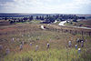
October 15, 1966 15 miles south of Hardin
45°31′20″N 107°22′39″W / 45.52222°N 107.3775°WHardin 20 Lodge Grass City Jail August 3, 1987 Alley south of 3rd Ave.
45°19′01″N 107°21′53″W / 45.316944°N 107.364722°WLodge Grass 21 Lodge Grass Merchandise Company Store August 3, 1987 1st Ave.
45°18′55″N 107°21′54″W / 45.315278°N 107.365°WLodge Grass 22 Moncure Tipi December 20, 2002 Montana Highway 212
45°31′46″N 106°57′28″W / 45.529444°N 106.957778°WBusby 23 OW Ranch December 15, 1992 Roughly 15 miles south of Birney on Hanging Woman Creek
45°08′10″N 106°28′39″W / 45.136111°N 106.4775°WBirney 24 George Pease's Second Store August 3, 1987 8 N. Main St.
45°18′57″N 107°21′49″W / 45.315833°N 107.363611°WLodge Grass 25 J.J. Ping House April 11, 1991 119 W. 6th St.
45°44′04″N 107°36′26″W / 45.734444°N 107.607222°WHardin 26 Reno Apartments April 11, 1991 719 N. Custer Ave.
45°44′08″N 107°37′10″W / 45.735556°N 107.619444°WHardin 27 Residential District August 14, 1985 Roughly bounded by 5th, 4th, Crow, and Cody
45°43′56″N 107°36′28″W / 45.732222°N 107.607778°WHardin 28 Rosebud Battlefield-Where the Girl Saved Her Brother 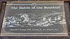
August 21, 1972 Montana Highway 314, 12 miles south of Kirby
45°13′17″N 106°59′21″W / 45.221389°N 106.989167°WKirby 29 John Ryan's House August 3, 1987 15 N. Helen St.
45°18′51″N 107°21′50″W / 45.314167°N 107.363889°WLodge Grass 30 St. Joseph Catholic Church April 11, 1991 710 N. Custer Ave.
45°44′09″N 107°36′26″W / 45.735833°N 107.607222°WHardin 31 St. Xavier Mission Church and Rectory August 17, 1990 On the Big Horn River in the Crow Indian Reservation
45°27′48″N 107°43′37″W / 45.463333°N 107.726944°WSt. Xavier 32 Jay Sharp's Store August 3, 1987 18 Helen St.
45°18′53″N 107°21′53″W / 45.314722°N 107.364722°WLodge Grass 33 Simmonsen's House August 3, 1987 4 S. George St.
45°18′49″N 107°22′05″W / 45.313611°N 107.368056°WLodge Grass 34 Dominic Stevens House August 3, 1987 10 W. Hester Ave.
45°18′49″N 107°22′03″W / 45.313611°N 107.3675°WLodge Grass 35 Sullivan Rooming House April 11, 1991 217 W. Sixth St.
45°44′05″N 107°36′34″W / 45.734722°N 107.609444°WHardin 36 James J. Sullivan House April 11, 1991 220 W. 3rd St.
45°43′52″N 107°36′32″W / 45.731111°N 107.608889°WHardin 37 J.M. Trytten House August 3, 1987 George St.
45°18′50″N 107°22′05″W / 45.313889°N 107.368056°WLodge Grass 38 J.S. Tupper House April 11, 1991 502 N. Cody
45°43′50″N 107°44′19″W / 45.730556°N 107.738611°WHardin 39 Alvin Young Barn and Cabin Historic District January 25, 2011 Rosebud Battlefield Rd., 3 miles west of MT 314 Busby vicinity See also
- List of National Historic Landmarks in Montana
- National Register of Historic Places listings in Montana
- Montana History Wiki section on National Register of Historic Places sign texts for Big Horn County.
References
- ^ The latitude and longitude information provided in this table was derived originally from the National Register Information System, which has been found to be fairly accurate for about 99% of listings. For about 1% of NRIS original coordinates, experience has shown that one or both coordinates are typos or otherwise extremely far off; some corrections may have been made. A more subtle problem causes many locations to be off by up to 150 yards, depending on location in the country: most NRIS coordinates were derived from tracing out latitude and longitudes off of USGS topographical quadrant maps created under the North American Datum of 1927, which differs from the current, highly accurate WGS84 GPS system used by Google maps. Chicago is about right, but NRIS longitudes in Washington are higher by about 4.5 seconds, and are lower by about 2.0 seconds in Maine. Latitudes differ by about 1.0 second in Florida. Some locations in this table may have been corrected to current GPS standards.
- ^ "National Register of Historic Places: Weekly List Actions". National Park Service, United States Department of the Interior. Retrieved on November 10, 2011.
- ^ Numbers represent an ordering by significant words. Various colorings, defined here, differentiate National Historic Landmark sites and National Register of Historic Places Districts from other NRHP buildings, structures, sites or objects.
U.S. National Register of Historic Places Topics Lists by states Alabama • Alaska • Arizona • Arkansas • California • Colorado • Connecticut • Delaware • Florida • Georgia • Hawaii • Idaho • Illinois • Indiana • Iowa • Kansas • Kentucky • Louisiana • Maine • Maryland • Massachusetts • Michigan • Minnesota • Mississippi • Missouri • Montana • Nebraska • Nevada • New Hampshire • New Jersey • New Mexico • New York • North Carolina • North Dakota • Ohio • Oklahoma • Oregon • Pennsylvania • Rhode Island • South Carolina • South Dakota • Tennessee • Texas • Utah • Vermont • Virginia • Washington • West Virginia • Wisconsin • WyomingLists by territories Lists by associated states Other Municipalities and communities of Big Horn County, Montana City 
Town CDPs Busby | Crow Agency | Fort Smith | Muddy | Pryor | St. Xavier | Wyola
Unincorporated
communitiesIndian reservations Footnotes ‡This populated place also has portions in an adjacent county or counties
Categories:- National Register of Historic Places in Montana by county
- Big Horn County, Montana
-


Wikimedia Foundation. 2010.