- National Register of Historic Places listings in Bradford County, Pennsylvania
-
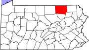
 Location of Bradford County in Pennsylvania
This is a list of the National Register of Historic Places listings in Bradford County, Pennsylvania.
This is intended to be a complete list of the properties and districts on the National Register of Historic Places in Bradford County, Pennsylvania, United States. The locations of National Register properties and districts for which the latitude and longitude coordinates are included below, may be seen in a Google map.[1]
There are 12 properties and districts listed on the National Register in the county.
-
- This National Park Service list is complete through NPS recent listings posted November 10, 2011.[2]
Current listings
[3] Landmark name Image Date listed Location City or town Summary 1 Athens Historic District June 18, 2004 Roughly bounded by Elm and Locust Streets, 772 South Main Street, and the Chemung and Susquehanna River
41°57′02″N 76°31′00″W / 41.950556°N 76.516667°WAthens 2 Phillip Paul Bliss House April 24, 1986 Main Street
41°51′29″N 76°20′32″W / 41.858056°N 76.342222°WRome 3 Bradford County Courthouse January 6, 1987 301 Main Street
41°45′59″N 76°26′21″W / 41.766389°N 76.439167°WTowanda 4 Bridge in Athens Township 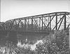
June 22, 1988 Legislative Route 08081 over the Susquehanna River
41°57′29″N 76°30′52″W / 41.958056°N 76.514444°WAthens and Athens Township 5 Knapp's Covered Bridge 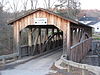
July 24, 1980 East of Burlington on Township 554
41°47′09″N 76°33′13″W / 41.785833°N 76.553611°WBurlington Township 6 Methodist Episcopal Church of Burlington January 4, 1990 U.S. Route 6 at Township 357
41°46′24″N 76°37′53″W / 41.773333°N 76.631389°WWest Burlington Township 7 Protection of the Flag Monument June 8, 2001 715 South Main Street
41°57′03″N 76°30′59″W / 41.950833°N 76.516389°WAthens 8 Spalding Memorial Library-Tioga Point Museum February 18, 2000 724 South Main Street
41°57′06″N 76°31′00″W / 41.951667°N 76.516667°WAthens 9 Towanda Historic District 
May 7, 1992 Roughly bounded by Elizabeth, Fourth, and Kingsbury Streets and the Susquehanna River
41°46′19″N 76°26′47″W / 41.771944°N 76.446389°WTowanda 10 Troy Public High School February 20, 2002 250 High Street
41°47′21″N 76°47′08″W / 41.789167°N 76.785556°WTroy 11 Van Dyne Civic Building January 21, 1974 Main and Elmira Streets
41°47′11″N 76°47′10″W / 41.786389°N 76.786111°WTroy 12 Ellen and Charles F. Welles House May 20, 1999 1 Grovedale Lane
41°39′38″N 76°15′27″W / 41.660556°N 76.2575°WWyalusing Township See also
- List of National Historic Landmarks in Pennsylvania
- National Register of Historic Places listings in Pennsylvania
- List of Pennsylvania state historical markers in Bradford County
References
- ^ The latitude and longitude information provided in this table was derived originally from the National Register Information System, which has been found to be fairly accurate for about 99% of listings. For about 1% of NRIS original coordinates, experience has shown that one or both coordinates are typos or otherwise extremely far off; some corrections may have been made. A more subtle problem causes many locations to be off by up to 150 yards, depending on location in the country: most NRIS coordinates were derived from tracing out latitude and longitudes off of USGS topographical quadrant maps created under the North American Datum of 1927, which differs from the current, highly accurate WGS84 GPS system used by Google maps. Chicago is about right, but NRIS longitudes in Washington are higher by about 4.5 seconds, and are lower by about 2.0 seconds in Maine. Latitudes differ by about 1.0 second in Florida. Some locations in this table may have been corrected to current GPS standards.
- ^ "National Register of Historic Places: Weekly List Actions". National Park Service, United States Department of the Interior. Retrieved on November 10, 2011.
- ^ Numbers represent an ordering by significant words. Various colorings, defined here, differentiate National Historic Landmark sites and National Register of Historic Places Districts from other NRHP buildings, structures, sites or objects.
Municipalities and communities of Bradford County, Pennsylvania Boroughs Alba | Athens | Burlington | Canton | Le Raysville | Monroe | New Albany | Rome | Sayre | South Waverly | Sylvania | Towanda | Troy | Wyalusing
Townships Albany | Armenia | Asylum | Athens | Burlington | Canton | Columbia | Franklin | Granville | Herrick | Leroy | Litchfield | Monroe | North Towanda | Orwell | Overton | Pike | Ridgebury | Rome | Sheshequin | Smithfield | South Creek | Springfield | Standing Stone | Stevens | Terry | Towanda | Troy | Tuscarora | Ulster | Warren | Wells | West Burlington | Wilmot | Windham | Wyalusing | Wysox
Unincorporated
communitiesBerrytown | Browntown
Categories:- National Register of Historic Places in Pennsylvania by county
- Bradford County, Pennsylvania
-


Wikimedia Foundation. 2010.