- National Register of Historic Places listings in Bristol Bay Borough, Alaska
-
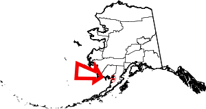 Location of the Bristol Bay Borough in Alaska
This is a list of the National Register of Historic Places listings in Bristol Bay Borough, Alaska.
This is intended to be a complete list of the properties and districts on the National Register of Historic Places in Bristol Bay Borough, Alaska, United States. The locations of National Register properties and districts for which the latitude and longitude coordinates are included below, may be seen in a Google map.[1]
There are 5 properties and districts listed on the National Register in the borough, including 1 National Historic Landmark.
-
- This National Park Service list is complete through NPS recent listings posted November 10, 2011.[2]
Current listings
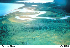
[3] Landmark name[4] Image Date listed Location Community Summary 1 Archeological Site 49 MK 10 June 23, 1978 Address Restricted Kanatak 2 Brooks River Archeological District 
February 14, 1978 Address Restricted Naknek 3 Elevation of Holy Cross Church June 6, 1980 In South Naknek
58°42′56″N 157°0′9″W / 58.71556°N 157.0025°WSouth Naknek 4 Old Savonoski Site June 23, 1978 On the northern side of the Savonoski River, near its mouth at Naknek Lake
58°32′0″N 155°19′0″W / 58.533333°N 155.316667°W[5]Naknek 14 St. John the Baptist Chapel June 6, 1980 In Naknek
58°43′42″N 157°0′31″W / 58.72833°N 157.00861°WNaknek 5 Savonoski River Archeological District June 23, 1978 Address Restricted Naknek See also
- List of National Historic Landmarks in Alaska
- National Register of Historic Places listings in Alaska
References
- ^ The latitude and longitude information provided in this table was derived originally from the National Register Information System, which has been found to be fairly accurate for about 99% of listings. For about 1% of NRIS original coordinates, experience has shown that one or both coordinates are typos or otherwise extremely far off; some corrections may have been made. A more subtle problem causes many locations to be off by up to 150 yards, depending on location in the country: most NRIS coordinates were derived from tracing out latitude and longitudes off of USGS topographical quadrant maps created under North American Datum of 1927, which differs from the current, highly accurate GPS system used by Google maps. Chicago is about right, but NRIS longitudes in Washington are higher by about 4.5 seconds, and are lower by about 2.0 seconds in Maine. Latitudes differ by about 1.0 second in Florida. Some locations in this table may have been corrected to current GPS standards.
- ^ "National Register of Historic Places: Weekly List Actions". National Park Service, United States Department of the Interior. Retrieved on November 10, 2011.
- ^ Numbers represent an ordering by significant words. Various colorings, defined here, differentiate National Historic Landmark sites and National Register of Historic Places Districts from other NRHP buildings, structures, sites or objects.
- ^ "National Register Information System". National Register of Historic Places. National Park Service. 2008-04-24. http://nrhp.focus.nps.gov/natreg/docs/All_Data.html.
- ^ Location derived from its GNIS feature record; the NRIS lists the site as "Address Restricted"
U.S. National Register of Historic Places Topics Lists by states Alabama • Alaska • Arizona • Arkansas • California • Colorado • Connecticut • Delaware • Florida • Georgia • Hawaii • Idaho • Illinois • Indiana • Iowa • Kansas • Kentucky • Louisiana • Maine • Maryland • Massachusetts • Michigan • Minnesota • Mississippi • Missouri • Montana • Nebraska • Nevada • New Hampshire • New Jersey • New Mexico • New York • North Carolina • North Dakota • Ohio • Oklahoma • Oregon • Pennsylvania • Rhode Island • South Carolina • South Dakota • Tennessee • Texas • Utah • Vermont • Virginia • Washington • West Virginia • Wisconsin • WyomingLists by territories Lists by associated states Other Properties on the National Register of Historic Places in Alaska  Boroughs
 Aleutians East • Anchorage • Bristol Bay • Denali • Fairbanks North Star • Haines • Juneau • Kenai Peninsula • Ketchikan Gateway • Kodiak Island • Lake and Peninsula • Matanuska-Susitna • North Slope • Northwest Arctic • Sitka • Skagway • Wrangell • YakutatCensus areasAleutians West • Bethel • Dillingham • Hoonah-Angoon • Nome • Petersburg • Prince of Wales-Hyder • Southeast Fairbanks • Valdez-Cordova • Yukon-KoyukukThere are no sites listed on the National Register of Historic Places in Wade Hampton Census Area
Municipalities and communities of Bristol Bay Borough, Alaska CDPs 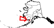 Categories:
- National Register of Historic Places in Alaska by borough and census area
- Bristol Bay Borough, Alaska
-


Wikimedia Foundation. 2010.