- National Register of Historic Places listings in Bureau County, Illinois
-
See also: List of Registered Historic Places in Illinois
Contents: List of Registered Historic Places in Bureau County, Illinois, USA:
-
- This National Park Service list is complete through NPS recent listings posted November 10, 2011.[1]
Landmark name Image Date listed Location City or Town Summary 1 Allen School February 16, 1996 301 Main St.
41°31′47″N 89°16′48″W / 41.52972°N 89.28°WLa Moille 2 First Congregational Church of LaMoille February 16, 1996 94 Franklin St.
41°31′51″N 89°16′47″W / 41.53083°N 89.27972°WLa Moille 3 First State Bank of Manlius May 12, 1975 N side of Maple St.
41°27′24″N 89°40′11″W / 41.45667°N 89.66972°WManlius 4 Greenwood Cottage May 9, 1983 543 E. Peru St.
41°21′46″N 89°27′12″W / 41.36278°N 89.45333°WPrinceton 5 Hennepin Canal Historic District 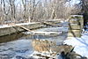
May 22, 1978 W To Moline then N to Rock Falls vic. Hennepin 6 Lone Tree School May 12, 2004 19292 250 North Avenue
41°11′11″N 89°29′11″W / 41.18639°N 89.48639°WTiskilwa 7 Owen Lovejoy Homestead 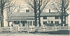
May 24, 1973 Peru St. (U.S. 6)
41°22′23″N 89°27′3″W / 41.37306°N 89.45083°WPrinceton 8 Old Danish Church October 2, 1973 SE corner of Cook and Washington Sts.
41°21′27″N 89°44′6″W / 41.3575°N 89.735°WSheffield 9 Princeton Chapter House November 28, 1980 1007 N. Main St.
41°23′5″N 89°27′53″W / 41.38472°N 89.46472°WPrinceton 10 Red Covered Bridge 
April 23, 1975 2 mi. N of Princeton off IL 26 on Old Dad Joe Trail
41°24′59″N 89°28′43″W / 41.41639°N 89.47861°WPrinceton 11 Richard M. Skinner House February 10, 1983 627 E. Peru St.
41°22′18″N 89°27′13″W / 41.37167°N 89.45361°WPrinceton 12 Stevens House November 5, 1992 140 E. Main St.
41°17′31″N 89°30′22″W / 41.29194°N 89.50611°WTiskilwa 13 Wood-Tellkamp House January 24, 1995 82 Main St.
41°32′0″N 89°16′49″W / 41.533333°N 89.28028°WLa Moille See also
- List of National Historic Landmarks in Illinois
- National Register of Historic Places listings in Illinois
References
- ^ "National Register of Historic Places: Weekly List Actions". National Park Service, United States Department of the Interior. Retrieved on November 10, 2011.
U.S. National Register of Historic Places Topics Lists by states Alabama • Alaska • Arizona • Arkansas • California • Colorado • Connecticut • Delaware • Florida • Georgia • Hawaii • Idaho • Illinois • Indiana • Iowa • Kansas • Kentucky • Louisiana • Maine • Maryland • Massachusetts • Michigan • Minnesota • Mississippi • Missouri • Montana • Nebraska • Nevada • New Hampshire • New Jersey • New Mexico • New York • North Carolina • North Dakota • Ohio • Oklahoma • Oregon • Pennsylvania • Rhode Island • South Carolina • South Dakota • Tennessee • Texas • Utah • Vermont • Virginia • Washington • West Virginia • Wisconsin • WyomingLists by territories Lists by associated states Other Categories:- Bureau County, Illinois
- National Register of Historic Places in Illinois by county
- National Register of Historic Places in Bureau County, Illinois
-


Wikimedia Foundation. 2010.