- National Register of Historic Places listings in Butler County, Nebraska
-
 Location of Butler County in Nebraska
This is a list of the National Register of Historic Places listings in Butler County, Nebraska. It is intended to be a complete list of the properties and districts on the National Register of Historic Places in Butler County, Nebraska, United States. The locations of National Register properties and districts for which the latitude and longitude coordinates are included below, may be seen in a Google map.[1]
There are 12 properties and districts listed on the National Register in the county.
-
- This National Park Service list is complete through NPS recent listings posted November 10, 2011.[2]
Listings county-wide
[3] Landmark name [4] Image Date listed Location City or town Summary 1 Barcal Site March 24, 1972 Address Restricted Abie 2 Bellwood Archeological Site August 13, 1974 Address Restricted Bellwood 3 Big Blue River Bridge 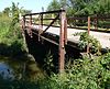
June 29, 1992 Township road over the Big Blue River, 1 mile southeast of Surprise
41°06′03″N 97°17′28″W / 41.100833°N 97.291111°WSurprise 4 Clear Creek Bridge 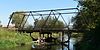
June 29, 1992 Township road over Clear Creek, 5.8 miles northwest of Bellwood
41°23′03″N 97°20′06″W / 41.384167°N 97.335°WBellwood 5 David City Park and Municipal Auditorium 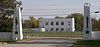
November 15, 2000 Southern side of town, bordering Nebraska Highway 15
41°14′45″N 97°07′26″W / 41.245833°N 97.123889°WDavid City 6 Fremont, Elkhorn and Missouri Valley Railroad Depot 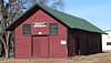
October 11, 1979 1st and Maple Sts.
41°04′58″N 97°01′06″W / 41.082778°N 97.018333°WDwight 7 Linwood Site March 16, 1972 Address Restricted Linwood 8 St. Mary of the Assumption Catholic Church, School and Grottoes December 4, 2008 336 W. Pine St.
41°05′01″N 97°01′23″W / 41.08354°N 97.02294°WDwight 9 Surprise Opera House 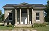
July 6, 1988 Southeastern corner of the intersection of Miller and River Sts.
41°06′10″N 97°18′38″W / 41.102778°N 97.310556°WSurprise 10 Chauncey S. Taylor House 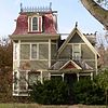
June 25, 1982 715 4th St.
41°15′23″N 97°08′32″W / 41.256389°N 97.142222°WDavid City 11 Thorpe's Opera House 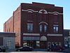
September 28, 1988 457½ D St.
41°15′09″N 97°07′44″W / 41.2525°N 97.128889°WDavid City 12 Upper Oak Creek Descent Ruts of the Woodbury Cutoff, Ox Bow Trail of the California Road November 27, 1992 Roughly 4 miles southeast of Brainard
41°07′40″N 96°58′14″W / 41.127778°N 96.970556°WBrainard See also
- List of National Historic Landmarks in Nebraska
- National Register of Historic Places listings in Nebraska
References
- ^ The latitude and longitude information provided in this table was derived originally from the National Register Information System, which has been found to be fairly accurate for about 99% of listings. For about 1% of NRIS original coordinates, experience has shown that one or both coordinates are typos or otherwise extremely far off; some corrections may have been made. A more subtle problem causes many locations to be off by up to 150 yards, depending on location in the country: most NRIS coordinates were derived from tracing out latitude and longitudes off of USGS topographical quadrant maps created under the North American Datum of 1927, which differs from the current, highly accurate WGS84 GPS system used by Google maps. Chicago is about right, but NRIS longitudes in Washington are higher by about 4.5 seconds, and are lower by about 2.0 seconds in Maine. Latitudes differ by about 1.0 second in Florida. Some locations in this table may have been corrected to current GPS standards.
- ^ "National Register of Historic Places: Weekly List Actions". National Park Service, United States Department of the Interior. Retrieved on November 10, 2011.
- ^ Numbers represent an ordering by significant words. Various colorings, defined here, differentiate National Historic Landmark sites and National Register of Historic Places Districts from other NRHP buildings, structures, sites or objects.
- ^ "National Register Information System". National Register of Historic Places. National Park Service. . http://nrhp.focus.nps.gov/natreg/docs/All_Data.html.
U.S. National Register of Historic Places Topics Lists by states Alabama • Alaska • Arizona • Arkansas • California • Colorado • Connecticut • Delaware • Florida • Georgia • Hawaii • Idaho • Illinois • Indiana • Iowa • Kansas • Kentucky • Louisiana • Maine • Maryland • Massachusetts • Michigan • Minnesota • Mississippi • Missouri • Montana • Nebraska • Nevada • New Hampshire • New Jersey • New Mexico • New York • North Carolina • North Dakota • Ohio • Oklahoma • Oregon • Pennsylvania • Rhode Island • South Carolina • South Dakota • Tennessee • Texas • Utah • Vermont • Virginia • Washington • West Virginia • Wisconsin • WyomingLists by territories Lists by associated states Other Municipalities and communities of Butler County, Nebraska City 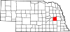
Villages Townships Alexis | Bone Creek | Center | Franklin | Linwood | Oak Creek | Olive | Platte | Plum Creek | Read | Reading | Richardson | Savannah | Skull Creek | Summit | Ulysses | Union
Unincorporated
communityCategories:- National Register of Historic Places in Nebraska by county
- Butler County, Nebraska
- Buildings and structures in Butler County, Nebraska
-


Wikimedia Foundation. 2010.