- National Register of Historic Places listings in Cape Girardeau County, Missouri
-
This is a list of properties and historic districts in Cape Girardeau County, Missouri, that are listed on the National Register of Historic Places. .
Contents: Counties in Missouri A–B · C · D–I · J–K · L–N · O–St. · St. Louis · Ste.–Z -
- This National Park Service list is complete through NPS recent listings posted November 10, 2011.[1]
Current listings
Landmark name Image Date listed Location City or Town Summary 1 B'Nai Israel Synagogue 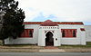
May 5, 2004 126 South Main
37°18′11″N 89°31′8″W / 37.30306°N 89.51889°WCape Girardeau 2 Bainbridge Ferry June 21, 2007 Cty Road 630
37°24′43″N 89°26′16″W / 37.41194°N 89.43778°WCape Girardeau 3 Bainbridge Ferry Road June 21, 2007 Cty Road 623
37°26′11.46″N 89°28′7.49″W / 37.4365167°N 89.4687472°WCape Girardeau 4 Bennett-Tobler-Pace-Oliver House April 18, 1985 224 East Adams
37°22′54″N 89°39′56″W / 37.38167°N 89.66556°WJackson 5 Big Hill Farmstead Historic District December 22, 1999 2246 MO PP
37°21′49″N 89°41′26″W / 37.36361°N 89.69056°WJackson 6 Broadway and North Fountain Street Historic District July 15, 2003 320-400 Broadway and 221 North Fountain Street
37°18′30″N 89°31′19″W / 37.30833°N 89.52194°WCape Girardeau 7 Broadway-Middle Commercial Historic District July 24, 2007 500 block of Broadway and 100 block of North Middle Street
37°18′22.82″N 89°31′25.36″W / 37.3063389°N 89.5237111°WCape Girardeau 8 Burfordville Covered Bridge May 19, 1970 E edge of Burfordville on CR HH
37°22′2″N 89°48′9″W / 37.36722°N 89.8025°WBurfordville 9 Burfordville Mill 
May 27, 1971 Off MO 34
37°22′5″N 89°48′6″W / 37.36806°N 89.80167°WBurfordville 10 Abraham Byrd House June 21, 2007 2832 Ct. Road 442
37°27′5″N 89°41′58″W / 37.45139°N 89.69944°WJackson 11 Cape Girardeau Commercial Historic District July 20, 2000 100 block of North Main Street and the 100 block of Broadway; also 101 North Main Street; also 127 North Water Street
37°18′26″N 89°31′6″W / 37.30722°N 89.51833°WCape Girardeau 101 N. Main and 127 N. Water represent boundary increases of July 11, 2007 and August 29, 2008 respectively 12 Cape Girardeau Court of Common Pleas 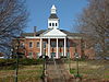
October 25, 2010 44 North Lorimier Street
37°18′18″N 89°31′12″W / 37.305°N 89.52°WCape Girardeau 13 Central High School July 18, 2008 101 South Pacific Street
37°18′10.6″N 89°31′49.29″W / 37.302944°N 89.5303583°WCape Girardeau 14 George Boardman Clark House July 22, 1994 6 South Fountain Street
37°18′12″N 89°31′21″W / 37.30333°N 89.5225°WCape Girardeau 15 Courthouse-Seminary Neighborhood Historic District September 9, 2010 Roughly bounded by Middle Street, Themis Street, Main Street, Aquamsi Street, and Morgan Oaks Street
37°18′5″N 89°31′17″W / 37.30139°N 89.52139°WCape Girardeau 16 Erlbacher Buildings July 8, 2009 1105 and 1107 Broadway
37°18′30.3″N 89°31′56.3″W / 37.308417°N 89.532306°WCape Girardeau 17 Esquire Theater September 15, 2005 824 Broadway
37°18′32″N 89°31′44″W / 37.30889°N 89.52889°WCape Girardeau 18 Frizel-Welling House June 25, 1999 209 West Main Street
37°22′57″N 89°40′10″W / 37.3825°N 89.66944°WJackson 19 Glenn House 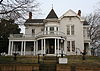
October 11, 1979 325 South Spanish Street
37°17′53″N 89°31′14″W / 37.29806°N 89.52056°WCape Girardeau 20 Green's Ferry 
June 21, 2007 Address Restricted Cape Girardeau 21 Haarig Commercial Historic District July 20, 2000 Along sections of the 600 block of Good Hope Street and 300 block of S. Sprigg Street
37°18′5″N 89°31′39″W / 37.30139°N 89.5275°WCape Girardeau 22 Hanover Lutheran Church 
September 14, 1987 2949 Perryville Road
37°21′10″N 89°33′37″W / 37.35278°N 89.56028°WCape Girardeau 23 William Henry and Lilla Luce Harrison House December 6, 2005 313 Themis Street
37°12′53″N 89°31′6″W / 37.21472°N 89.51833°WCape Girardeau 24 Himmelberger and Harrison Building July 17, 2003 400 Broadway
37°18′30″N 89°31′20″W / 37.30833°N 89.52222°WCape Girardeau 25 House at 323 Themis Street June 27, 1997 323 Themis Street
37°18′18″N 89°31′18″W / 37.305°N 89.52167°WCape Girardeau 26 Huhn-Harrison House June 27, 2002 340 South Lorimier Street
37°18′0″N 89°31′22″W / 37.3°N 89.52278°WCape Girardeau 27 Jackson Uptown Commercial Historic District February 1, 2006 Roughly bounded by Court, Main, Missouri and High Sts.
37°22′57″N 89°40′6.37″W / 37.3825°N 89.6684361°WJackson 28 Jefferson School May 12, 2009 731 Jefferson Ave
37°17′49.16″N 89°31′42.66″W / 37.2969889°N 89.5285167°WCape Girardeau Demolished in 2011.[2] 29 Kage School September 29, 2005 3110 Kage Road
37°19′57″N 89°34′45″W / 37.3325°N 89.57917°WCape Girardeau 30 Klostermann Block July 22, 1994 7, 9, 11, 13 and 15 S. Spanish Street
37°18′11″N 89°31′12″W / 37.30306°N 89.52°WCape Girardeau 31 Edward S. and Mary Annatoile Albert Lilly House June 20, 2008 129 S. Lorimier
37°18′5.86″N 89°31′17.19″W / 37.3016278°N 89.5214417°WCape Girardeau 32 Main-Spanish Commercial Historic District December 30, 2008 Roughly the 100 blocks of Main and Spanish Sts. and adjacent portions of Themis and Independence
37°18′15.14″N 89°31′8.09″W / 37.3042056°N 89.5189139°WCape Girardeau 33 Marquette Hotel April 11, 2002 338 Broadway Street
37°18′30″N 89°31′19″W / 37.30833°N 89.52194°WCape Girardeau 34 McKendree Chapel April 13, 1987 Off Interstate 55; also the southern side of Bainbridge Road, 0.5 miles west of Interstate 55
37°22′41″N 89°37′7″W / 37.37806°N 89.61861°WJackson Specific address represents a boundary increase of February 14, 2006 35 Miller-Seabaugh House and Dr. Seabaugh Office Building January 4, 1996 341 Market Street
37°25′58″N 89°47′52″W / 37.43278°N 89.79778°WMillersville 36 Old Appleton Bridge August 25, 2009 Main Street over Apple Creek
37°35′51.5″N 89°42′49.5″W / 37.597639°N 89.71375°WOld Appleton 37 Old Lorimier Cemetery 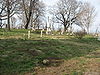
September 28, 2005 500 N. Fountain
37°18′43″N 89°31′13″W / 37.31194°N 89.52028°WCape Girardeau 38 Oliver-Leming House September 12, 1980 740 North Street
37°18′35″N 89°31′40″W / 37.30972°N 89.52778°WCape Girardeau 39 Abraham Russell Ponder House March 27, 2008 141 S. Louisiana Ave.
37°18′15″N 89°32′17″W / 37.30417°N 89.53806°WCape Girardeau 40 Frederick W. and Mary Karau Pott House June 25, 1999 826 Themis Street
37°18′28″N 89°31′46″W / 37.30778°N 89.52944°WCape Girardeau 41 James Reynolds House October 13, 1983 623 N. Main Street
37°18′41″N 89°31′5″W / 37.31139°N 89.51806°WCape Girardeau 42 August and Amalia Shivelbine House June 25, 1999 303 S. Spanish Street
37°18′2″N 89°31′14″W / 37.30056°N 89.52056°WCape Girardeau 43 South Middle Street Historic District October 14, 2009 513 William Street, 202-230 S. Middle Street, and 203-229 S. Middle
37°18′2.67″N 89°31′28.19″W / 37.3007417°N 89.5244972°WCape Girardeau 44 Southeast Missourian Building June 1, 2005 301 Broadway
37°18′28″N 89°31′16″W / 37.30778°N 89.52111°WCape Girardeau 45 Saint Vincent De Paul Catholic Church 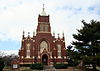
April 12, 1982 131 South Main Street
37°18′4″N 89°31′8″W / 37.30111°N 89.51889°WCape Girardeau 46 Saint Vincent's College Building September 30, 2005 201 Morgan Oak Street
37°17′57″N 89°31′16″W / 37.29917°N 89.52111°WCape Girardeau 47 Col George C. Thilenius House April 14, 1983 100 Longview Pl.
37°18′23″N 89°32′46″W / 37.30639°N 89.54611°WCape Girardeau 48 Trail of Tears State Park Archeological Site December 2, 1970 Address Restricted Oriole An archeological site in Trail of Tears State Park 49 Julius Vasterling Building June 17, 2009 633-637 Broadway
37°18′23″N 89°32′46″W / 37.30639°N 89.54611°WCape Girardeau 50 Warehouse Row Historic District December 4, 2004 19 N. Water Street
37°18′23″N 89°31′4″W / 37.30639°N 89.51778°WCape Girardeau 51 Robert Felix and Elma Taylor Wichterich House August 12, 1999 300 Good Hope Street
37°17′57″N 89°31′18″W / 37.29917°N 89.52167°WCape Girardeau 52 Wood Building December 10, 2003 1-3 S. Frederick and 605-607 Independence Streets
37°18′21″N 89°31′33″W / 37.30583°N 89.52583°WCape Girardeau References
- ^ "National Register of Historic Places: Weekly List Actions". National Park Service, United States Department of the Interior. Retrieved on November 10, 2011.
- ^ http://www.semissourian.com/story/1760149.html
Municipalities and communities of Cape Girardeau County, Missouri Cities Cape Girardeau‡ | Delta | Jackson | Scott City‡

Villages Allenville | Dutchtown | Gordonville | Oak Ridge | Old Appleton | Pocahontas | Whitewater
Townships Apple Creek | Byrd | Cape Girardeau | Hubble | Kinder | Liberty | Randol | Shawnee | Welch | Whitewater
Unincorporated
communitiesBurfordville | Daisy | Egypt Mills | Friedheim | Fruitland | Millersville | New Wells | Oriole
Footnotes ‡This populated place also has portions in an adjacent county or counties
U.S. National Register of Historic Places Topics Lists by states Alabama • Alaska • Arizona • Arkansas • California • Colorado • Connecticut • Delaware • Florida • Georgia • Hawaii • Idaho • Illinois • Indiana • Iowa • Kansas • Kentucky • Louisiana • Maine • Maryland • Massachusetts • Michigan • Minnesota • Mississippi • Missouri • Montana • Nebraska • Nevada • New Hampshire • New Jersey • New Mexico • New York • North Carolina • North Dakota • Ohio • Oklahoma • Oregon • Pennsylvania • Rhode Island • South Carolina • South Dakota • Tennessee • Texas • Utah • Vermont • Virginia • Washington • West Virginia • Wisconsin • WyomingLists by territories Lists by associated states Other Categories:- Cape Girardeau County, Missouri
- National Register of Historic Places in Missouri
-


Wikimedia Foundation. 2010.