- National Register of Historic Places listings in Carbon County, Wyoming
-
 Location of Carbon County in Wyoming
This is a list of the National Register of Historic Places listings in Carbon County, Wyoming.
It is intended to be a complete list of the properties and districts on the National Register of Historic Places in Carbon County, Wyoming, United States. The locations of National Register properties and districts for which the latitude and longitude coordinates are included below, may be seen in a Google map.[1]
There are 44 properties and districts listed on the National Register in the county, 1 of which is a National Historic Landmark.
-
- This National Park Service list is complete through NPS recent listings posted November 10, 2011.[2]
Contents: Counties in Wyoming Albany - Big Horn - Campbell - Carbon - Converse - Crook - Fremont - Goshen - Hot Springs - Johnson - Laramie - Lincoln - Natrona - Niobrara - Park - Platte - Sheridan - Sublette - Sweetwater - Teton - Uinta - Washakie - Weston Current listings
[3] Landmark name Image Date listed Location City or town Summary 1 Garrett Allen Prehistoric Site 
August 7, 1974 Address Restricted[4] Elk Mountain 2 Arlington November 25, 1983 South of Interstate 180
41°35′42″N 106°12′34″W / 41.595°N 106.209444°WArlington 3 Jim Baker Cabin November 8, 1982 Off Wyoming Highway 70
41°01′36″N 107°26′57″W / 41.026667°N 107.449167°WSavery 4 Bridger's Pass April 28, 1970 Southwest of Rawlins
41°33′03″N 107°26′04″W / 41.550833°N 107.434444°WRawlins 5 Brush Creek Work Center April 11, 1994 Wyoming Highway 130 east of Saratoga, Medicine Bow National Forest
41°20′45″N 106°32′14″W / 41.345833°N 106.537222°WSaratoga 6 Carbon Cemetery April 7, 2011 County Road 115 Carbon 7 Como Bluff 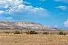
January 18, 1973 On U.S. Route 30 along Como Ridge
41°53′13″N 106°03′24″W / 41.886944°N 106.056667°WMedicine Bow Extends into Albany County 8 DFU Elk Mountain Bridge 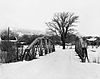
February 22, 1985 County Road 120-1
41°41′12″N 106°24′34″W / 41.686667°N 106.409444°WElk Mountain 9 Divide Sheep Camp February 9, 1984 Northeast of Baggs
41°06′54″N 107°17′19″W / 41.115°N 107.288611°WBaggs 10 DMJ Pick Bridge 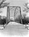
February 22, 1985 Road CN6-508 (Pick Bridge Rd.)
41°32′22″N 106°52′51″W / 41.539444°N 106.880833°WSaratoga 11 DML-Butler Bridge 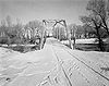
February 22, 1985 County Road CN6-203
41°15′23″N 106°38′22″W / 41.256389°N 106.639444°WGrand Encampment 12 Downtown Rawlins Historic District May 16, 1985 Roughly 2nd to 6th Sts. and Front to Buffalo Sts.; also roughly along 5th St. from W. Spruce to W. Cedar
41°47′16″N 107°14′18″W / 41.787778°N 107.238333°WRawlins Second set of boundaries represents a boundary increase 13 Duck Lake Station Site December 6, 1978 Address Restricted[4] Wamsutter 14 Elk Mountain Hotel October 10, 1986 Bridge St. and County Road 402
41°41′15″N 106°24′40″W / 41.6875°N 106.411111°WElk Mountain 15 George Ferris Mansion 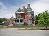
November 1, 1982 607 W. Maple St.
41°47′29″N 107°14′34″W / 41.791389°N 107.242778°WRawlins 16 First State Bank of Baggs September 13, 1984 10 S. Miles St.
41°02′09″N 107°39′31″W / 41.035833°N 107.658611°WBaggs 17 Fort Halleck April 28, 1970 Southwest of Elk Mountain
41°41′53″N 106°30′55″W / 41.698056°N 106.515278°WElk Mountain 18 Fort Steele April 16, 1969 On the North Platte River at the Union Pacific railroad crossing
41°46′38″N 106°56′51″W / 41.777222°N 106.9475°WFort Fred Steele 19 The Fossil Cabin April 11, 2008 U.S. Route 30
41°51′55″N 106°04′23″W / 41.865222°N 106.073125°WMedicine Bow 20 France Memorial United Presbyterian Church 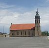
May 14, 1984 3rd and Cedar Sts.
41°47′17″N 107°14′14″W / 41.788056°N 107.237222°WRawlins 21 Grand Encampment Mining Region: Boston Wyoming Smelter Site July 2, 1973 East of Encampment on the Encampment River
41°12′35″N 106°46′46″W / 41.209722°N 106.779444°WGrand Encampment 22 Grand Encampment Mining Region: Ferris-Haggarty Mine Site July 2, 1973 West of Encampment
41°11′15″N 107°04′26″W / 41.1875°N 107.073889°WGrand Encampment 23 Hanna Community Hall November 26, 1983 Front St.
41°52′09″N 106°33′51″W / 41.869167°N 106.564167°WHanna 24 Hotel Wolf November 21, 1974 101 E. Bridge St.
41°27′17″N 106°48′24″W / 41.454722°N 106.806667°WSaratoga 25 Hugus Hardware April 5, 1984 123 E. Bridge St.
41°27′17″N 106°48′21″W / 41.454722°N 106.805833°WSaratoga 26 Jack Creek Guard Station May 15, 1986 Off FDR 452
41°16′23″N 107°06′32″W / 41.273056°N 107.108889°WSaratoga 27 J. O. Ranch Rural Historic Landscape November 22, 2010 24 miles northeast of Baggs
41°21′10″N 107°35′59″W / 41.35278°N 107.59972°W[5]Baggs vicinity 28 Medicine Bow Union Pacific Depot November 1, 1982 405 Lincoln Highway
41°53′43″N 106°11′59″W / 41.895278°N 106.199722°WMedicine Bow 29 Midway Station Site December 6, 1978 Address Restricted[4] Rawlins 30 Parco Historic District 
May 6, 1987 Roughly bounded by Monroe Ave., N. 4th St., Union and Lincoln Aves., and N. 9th St.
41°46′47″N 107°07′04″W / 41.779722°N 107.117778°WSinclair 31 Pine Grove Station Site November 21, 1978 Address Restricted[4] Rawlins 32 Platte River Crossing August 12, 1971 17 miles west of Saratoga
41°34′21″N 106°57′45″W / 41.5725°N 106.9625°WSaratoga 33 Rawlins Residential Historic District September 9, 1999 Roughly bounded by 8th St., Walnut St., Wyoming St., and Pine St.
41°47′28″N 107°14′19″W / 41.791111°N 107.238611°WRawlins 34 Ryan Ranch March 29, 1978 South of Saratoga off Wyoming Highway 130
41°22′21″N 106°43′01″W / 41.3725°N 106.716944°WSaratoga 35 Sage Creek Station Site December 6, 1978 Address Restricted[4] Rawlins 36 Saratoga Masonic Hall March 29, 1978 1st and Main Sts.
41°27′20″N 106°48′26″W / 41.455556°N 106.807222°WSaratoga 37 Stockgrowers Bank June 25, 1986 Third St.
41°02′04″N 107°32′08″W / 41.034444°N 107.535556°WDixon 38 Stone Wall Ranch September 29, 1986 Star Rt., Box 1300
41°01′10″N 107°25′13″W / 41.019444°N 107.420278°WSavery 39 Tom Sun Ranch 
October 15, 1966 6 miles west of Independence Rock on Wyoming Highway 220
42°26′40″N 107°14′36″W / 42.444444°N 107.243333°WIndependence Rock 40 Union Pacific Railroad Depot September 2, 1993 Junction of N. Front and 4th Sts.
41°47′13″N 107°14′18″W / 41.786944°N 107.238333°WRawlins 41 Virginian Hotel May 22, 1978 U.S. Route 30
41°53′46″N 106°11′59″W / 41.896111°N 106.199722°WMedicine Bow 42 Washakie Station Site December 12, 1978 Address Restricted[4] Rawlins 43 Willis House March 29, 2001 621 Winchell Ave.
41°12′27″N 106°47′42″W / 41.2075°N 106.795°WGrand Encampment 44 Wyoming State Penitentiary District 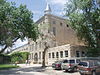
May 26, 1983 6th and Walnut Sts.
41°47′37″N 107°14′26″W / 41.793611°N 107.240556°WRawlins See also
- List of National Historic Landmarks in Wyoming
- National Register of Historic Places listings in Wyoming
References
- ^ The latitude and longitude information provided in this table was derived originally from the National Register Information System, which has been found to be fairly accurate for about 99% of listings. For about 1% of NRIS original coordinates, experience has shown that one or both coordinates are typos or otherwise extremely far off; some corrections may have been made. A more subtle problem causes many locations to be off by up to 150 yards, depending on location in the country: most NRIS coordinates were derived from tracing out latitude and longitudes off of USGS topographical quadrant maps created under the North American Datum of 1927, which differs from the current, highly accurate WGS84 GPS system used by Google maps. Chicago is about right, but NRIS longitudes in Washington are higher by about 4.5 seconds, and are lower by about 2.0 seconds in Maine. Latitudes differ by about 1.0 second in Florida. Some locations in this table may have been corrected to current GPS standards.
- ^ "National Register of Historic Places: Weekly List Actions". National Park Service, United States Department of the Interior. Retrieved on November 10, 2011.
- ^ Numbers represent an ordering by significant words. Various colorings, defined here, differentiate National Historic Landmark sites and National Register of Historic Places Districts from other NRHP buildings, structures, sites or objects.
- ^ a b c d e f Some listings on the NRHP are highly sensitive sites and may be subject to looting or vandalism. The NRHP lists this site as "Address Restricted."
- ^ U.S. Geological Survey. Geographic Names Phase I data compilation (1976-1981). 31-Dec-1981.
U.S. National Register of Historic Places Topics Lists by states Alabama • Alaska • Arizona • Arkansas • California • Colorado • Connecticut • Delaware • Florida • Georgia • Hawaii • Idaho • Illinois • Indiana • Iowa • Kansas • Kentucky • Louisiana • Maine • Maryland • Massachusetts • Michigan • Minnesota • Mississippi • Missouri • Montana • Nebraska • Nevada • New Hampshire • New Jersey • New Mexico • New York • North Carolina • North Dakota • Ohio • Oklahoma • Oregon • Pennsylvania • Rhode Island • South Carolina • South Dakota • Tennessee • Texas • Utah • Vermont • Virginia • Washington • West Virginia • Wisconsin • WyomingLists by territories Lists by associated states Other Municipalities and communities of Carbon County, Wyoming City 
Towns Baggs | Dixon | Elk Mountain | Grand Encampment | Hanna | Medicine Bow | Riverside | Saratoga | Sinclair
Unincorporated
communitiesCategories:- National Register of Historic Places in Wyoming by county
- Carbon County, Wyoming
-


Wikimedia Foundation. 2010.