- National Register of Historic Places listings in Caroline County, Virginia
-
This list includes properties and districts listed on the National Register of Historic Places in Caroline County, Virginia. Click the "Map of all coordinates" link to the right to view a Google map of all properties and districts with latitude and longitude coordinates in the table below.[1]
-
- This National Park Service list is complete through NPS recent listings posted November 10, 2011.[2]
[3] Landmark name[4] Image Date listed Location City or Town Summary 1 Auburn May 3, 2006 320 N. Main St.
38°3′34″N 77°21′22″W / 38.05944°N 77.35611°WBowling Green 2 Bowling Green Historic District May 22, 2003 Roughly along and bounded by Bowling Green Bypass, Broadus Ave., Lakewood Rd., N. Main St., and Paige Rd.
38°3′3″N 77°21′0″W / 38.05083°N 77.35°WBowling Green 3 Camden 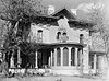
November 12, 1969 Address Restricted Port Royal 4 Caroline County Courthouse 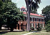
May 25, 1973 Main St. and Court House Lane
38°3′3″N 77°20′50″W / 38.05083°N 77.34722°WBowling Green 5 Edge Hill February 10, 1983 W of Woodford on VA 632
38°7′3″N 77°27′37″W / 38.1175°N 77.46028°WWoodford 6 Gay Mont 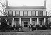
May 19, 1972 Off U.S. 17 near jct. with U.S. 301
38°10′11″N 77°13′54″W / 38.16972°N 77.23167°WPort Royal 7 Green Falls May 23, 1997 Jct of VA 627 and VA 623
37°57′29″N 77°18′25″W / 37.95806°N 77.30694°WBowling Green 8 The Grove May 21, 2009 33115 Mount Gideon Rd. Hanover 9 Hazelwood January 11, 1974 Address Restricted Port Royal 10 Jericho School February 11, 2004 Jericho Rd.
37°55′44″N 77°30′44″W / 37.92889°N 77.51222°WRuther Glen 11 Moss Neck Manor January 27, 1999 VA 766, S side of Rappahannock R.
38°12′26″N 77°19′47″W / 38.20722°N 77.32972°WRappahannock Academy 12 Old Mansion 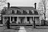
November 12, 1969 S of jct. of U.S. 301 and VA 207
38°2′40″N 77°21′14″W / 38.04444°N 77.35389°WBowling Green 13 Port Royal Historic District February 16, 1970 Roughly bounded by Rappahannock River, Roys Run, Rt. 17, and Goldenville Creek
38°10′10″N 77°11′29″W / 38.16944°N 77.19139°WPort Royal 14 Prospect Hill December 12, 1976 SE of Fredericksburg off U.S. 17
38°13′31″N 77°21′55″W / 38.22528°N 77.36528°WFredericksburg 15 Riverview July 29, 1994 Water St.
38°10′15″N 77°11′17″W / 38.17083°N 77.18806°WPort Royal 16 Santee May 7, 1979 Off VA 610
38°13′3″N 77°21′40″W / 38.2175°N 77.36111°WCorbin 17 Spring Grove December 12, 1976 Address Restricted Oak Corner 18 Townfield July 29, 1994 Water St.
38°10′12″N 77°11′18″W / 38.17°N 77.18833°WPort Royal See also
- National Register of Historic Places listings in Virginia
- List of National Historic Landmarks in Virginia
References
- ^ The latitude and longitude information provided in this table was derived originally from the National Register Information System, which has been found to be fairly accurate for about 99% of listings. For about 1% of NRIS original coordinates, experience has shown that one or both coordinates are typos or otherwise extremely far off; some corrections may have been made. A more subtle problem causes many locations to be off by up to 150 yards, depending on location in the country: most NRIS coordinates were derived from tracing out latitude and longitudes off of USGS topographical quadrant maps created under North American Datum of 1927, which differs from the current, highly accurate GPS system used by Google maps. Chicago is about right, but NRIS longitudes in Washington are higher by about 4.5 seconds, and are lower by about 2.0 seconds in Maine. Latitudes differ by about 1.0 second in Florida. Some locations in this table may have been corrected to current GPS standards.
- ^ "National Register of Historic Places: Weekly List Actions". National Park Service, United States Department of the Interior. Retrieved on November 10, 2011.
- ^ Numbers represent an ordering by significant words. Various colorings, defined here, differentiate National Historic Landmark sites and National Register of Historic Places Districts from other NRHP buildings, structures, sites or objects.
- ^ "National Register Information System". National Register of Historic Places. National Park Service. 2008-04-24. http://nrhp.focus.nps.gov/natreg/docs/All_Data.html.
U.S. National Register of Historic Places Topics Lists by states Alabama • Alaska • Arizona • Arkansas • California • Colorado • Connecticut • Delaware • Florida • Georgia • Hawaii • Idaho • Illinois • Indiana • Iowa • Kansas • Kentucky • Louisiana • Maine • Maryland • Massachusetts • Michigan • Minnesota • Mississippi • Missouri • Montana • Nebraska • Nevada • New Hampshire • New Jersey • New Mexico • New York • North Carolina • North Dakota • Ohio • Oklahoma • Oregon • Pennsylvania • Rhode Island • South Carolina • South Dakota • Tennessee • Texas • Utah • Vermont • Virginia • Washington • West Virginia • Wisconsin • WyomingLists by territories Lists by associated states Other  Category:National Register of Historic Places •
  Portal:National Register of Historic Places
Municipalities and communities of Caroline County, Virginia County seat: Bowling Green Towns 
CDPs Lake Caroline | Lake Land'Or
Unincorporated
communitiesAcors Corner | Ann Wrights Corner | Antioch Fork | Athens | Bagby | Bagdad | Balty | Baylortown | Blantons | Bowersville | Brandywine | Broaddus | Broadus Corner | Bullocks Corner | Burruss Corner | Butlers Fork | Camden | Campbell Corner | Campbells Corner | Caroline Pines | Carters Corner | Cash Corner | Cedar Fork | Cedon | Central Point | Chandler Crossing | Chenaults Shop | Chilesburg | Christopher Fork | Claiborne | Coffey Corner | Colemans Mill Crossing | Collins Crossing | Corbin | Covingston Corner | Daltons | Daniel Corner | Davis Corner | DeJarnette | Delos | Doggetts Fork | Edgar | Elevon | Etta | Eubank Corner | Featherstone Fork | Flippos Corner | Gether | Golansville | Goldmans Corner | Guinea | Haleys Corner | Hard Corner | Hart Corner | Haymount | Hazelwood | Hickory Fork | Hicks Mill | Houstons Corner | Howards Corner | Jones Corner | Kemp Corner | Kidds Fork | Ladysmith | Lauraville | Lent | Liberty | Liberty Fork | Locks Corner | Long Branch | Lorne | Loving Fork | Martins Corner | Maryton | McBryant Corner | McDuff | Mica | Milford | Moncure Corner | Monroe Corner | Moss Neck | Nancy Wrights Corner | Naulakla | New London | Oak Corner | Olive | Olney Corner | Paige | Patersons Corner | Peatross | Penny Corner | Penola | Poorhouse Corner | Poplar | Port Royal Cross Roads | Portobago | Pullers Corner | Raines Corner | Range Corner | Rappahannock Academy | Rappahannock Corner | Raymonds Fork | Reedy Mill | Rixey | Ruther Glen | Ryland Corner | Sales Corner | Samuels Corner | Shumansville | Signboard | Skinkers Corner | Smoots | Sorrell | Sparta | Stuart Corner | Swans Corner | Taylors Corner | Tignor | Travis Mill | Upper Zion | Valleyview Corner | Villboro | Wallers Corner | Washington Corner | Waverly | Welchs | Woodford | Wrights Corner | Wrights Fork | Wrightsville | Young Corner
Categories:- Caroline County, Virginia
- National Register of Historic Places in Virginia
- Virginia-related lists
-


Wikimedia Foundation. 2010.