- National Register of Historic Places listings in Charles Mix County, South Dakota
-
 Location of Charles Mix County in South Dakota
This is a list of the National Register of Historic Places listings in Charles Mix County, South Dakota.
This is intended to be a complete list of the properties and districts on the National Register of Historic Places in Charles Mix County, South Dakota, United States. The locations of National Register properties and districts for which the latitude and longitude coordinates are included below, may be seen in a Google map.[1]
There are 11 properties and districts listed on the National Register in the county.
-
- This National Park Service list is complete through NPS recent listings posted November 10, 2011.[2]
Current listings
[3] Landmark name [4] Image Date listed Location City or town Summary 1 Charles Mix County Courthouse 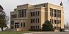
February 10, 1993 Main St. between 4th and 5th Sts.
43°09′20″N 98°32′16″W / 43.155556°N 98.537778°WLake Andes 2 Church of Christ in LaRoche Township July 1, 1982 Highway 50
43°27′21″N 99°04′55″W / 43.455833°N 99.081944°WAcademy 3 Farmers State Bank of Platte January 27, 1983 404 N. Main St.
43°23′13″N 98°50′40″W / 43.386944°N 98.844444°WPlatte 4 Geddes Historic District May 8, 1973 Off Highway 50
43°15′15″N 98°41′43″W / 43.254167°N 98.695278°WGeddes 5 Henry Cool Park March 15, 2011 ½ mi. north of intersection of Highway 50 and 365th Ave
43°23′16″N 98°53′35″W / 43.387778°N 98.893056°WPlatte vicinity 6 Holy Fellowship Episcopal Church June 5, 1975 Southeast of Greenwood
42°55′23″N 98°23′10″W / 42.923056°N 98.386111°WGreenwood 7 Jacobson School February 5, 2003 289th St.
43°11′54″N 98°19′38″W / 43.198333°N 98.327222°WArmour 8 Lake Andes Carnegie Library 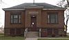
June 2, 2000 500 Main St.
43°09′21″N 98°32′18″W / 43.155833°N 98.538333°WLake Andes 9 Pratt & Cjolme Building June 8, 2007 500 S. Main
43°23′17″N 98°50′42″W / 43.388056°N 98.845°WPlatte 10 Rising Hail Colony April 28, 1975 5 miles northwest of Greenwood along Seven Mile Creek
43°00′13″N 98°28′58″W / 43.003611°N 98.482778°WGreenwood 11 Wagner House November 19, 2007 29649 401st. Ave.
43°05′31″N 98°10′31″W / 43.091944°N 98.175278°WWagner See also
- List of National Historic Landmarks in South Dakota
- National Register of Historic Places listings in South Dakota
References
- ^ The latitude and longitude information provided in this table was derived originally from the National Register Information System, which has been found to be fairly accurate for about 99% of listings. For about 1% of NRIS original coordinates, experience has shown that one or both coordinates are typos or otherwise extremely far off; some corrections may have been made. A more subtle problem causes many locations to be off by up to 150 yards, depending on location in the country: most NRIS coordinates were derived from tracing out latitude and longitudes off of USGS topographical quadrant maps created under the North American Datum of 1927, which differs from the current, highly accurate WGS84 GPS system used by Google maps. Chicago is about right, but NRIS longitudes in Washington are higher by about 4.5 seconds, and are lower by about 2.0 seconds in Maine. Latitudes differ by about 1.0 second in Florida. Some locations in this table may have been corrected to current GPS standards.
- ^ "National Register of Historic Places: Weekly List Actions". National Park Service, United States Department of the Interior. Retrieved on November 10, 2011.
- ^ Numbers represent an ordering by significant words. Various colorings, defined here, differentiate National Historic Landmark sites and National Register of Historic Places Districts from other NRHP buildings, structures, sites or objects.
- ^ "National Register Information System". National Register of Historic Places. National Park Service. . http://nrhp.focus.nps.gov/natreg/docs/All_Data.html.
U.S. National Register of Historic Places Topics Lists by states Alabama • Alaska • Arizona • Arkansas • California • Colorado • Connecticut • Delaware • Florida • Georgia • Hawaii • Idaho • Illinois • Indiana • Iowa • Kansas • Kentucky • Louisiana • Maine • Maryland • Massachusetts • Michigan • Minnesota • Mississippi • Missouri • Montana • Nebraska • Nevada • New Hampshire • New Jersey • New Mexico • New York • North Carolina • North Dakota • Ohio • Oklahoma • Oregon • Pennsylvania • Rhode Island • South Carolina • South Dakota • Tennessee • Texas • Utah • Vermont • Virginia • Washington • West Virginia • Wisconsin • WyomingLists by territories Lists by associated states Other Municipalities and communities of Charles Mix County, South Dakota Cities Geddes | Lake Andes | Platte | Wagner

Towns CDP Indian reservation Categories:- Charles Mix County, South Dakota
- National Register of Historic Places in South Dakota by county
-


Wikimedia Foundation. 2010.