- National Register of Historic Places listings in Cheyenne County, Nebraska
-
 Location of Cheyenne County in Nebraska
This is a list of the National Register of Historic Places listings in Cheyenne County, Nebraska. It is intended to be a complete list of the properties and districts on the National Register of Historic Places in Cheyenne County, Nebraska, United States. The locations of National Register properties and districts for which the latitude and longitude coordinates are included below, may be seen in a Google map.[1]
There are 12 properties and districts listed on the National Register in the county.
-
- This National Park Service list is complete through NPS recent listings posted November 10, 2011.[2]
Listings county-wide
[3] Landmark name Image Date listed Location City or town Summary 1 Brownson Viaduct 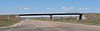
June 29, 1992 Spur 17A over U.S. Route 30 and Union Pacific tracks, 0.8 miles northwest of Brownson
41°11′22″N 103°07′17″W / 41.189444°N 103.121389°WBrownson Apparently removed and replaced by a modern concrete beam bridge: see photo 2 Christ Episcopal Church 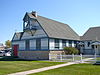
October 21, 1994 Junction of 10th Ave. and Linden St.
41°08′30″N 102°58′32″W / 41.141667°N 102.975556°WSidney 3 Deadwood Draw 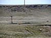
November 12, 1992 Northwest of Sidney
41°09′35″N 103°00′28″W / 41.159722°N 103.007778°WSidney 4 Fort Sidney Historic District 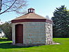
March 28, 1973 Roughly bounded by 6th and 5th Aves., Linden and Jackson
41°08′35″N 102°58′10″W / 41.143056°N 102.969444°WSidney 5 Daniel and Sarah Herboldsheimer Ranch 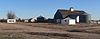
April 5, 1990 Northeast of Potter
41°16′44″N 103°13′26″W / 41.278889°N 103.223889°WPotter 6 Lodgepole Opera House 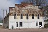
July 7, 1988 Western side of Oberfelder at Front
41°08′52″N 102°38′19″W / 41.147778°N 102.638611°WLodgepole 7 Sidney Carnegie Library 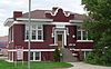
July 3, 1991 740 Illinois St.
41°08′43″N 102°58′25″W / 41.145278°N 102.973611°WSidney 8 Sidney Historic Business District 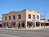
October 21, 1994 Roughly bounded by Hickory and King Sts. and 9th and 11th Aves.; also roughly bounded by Hickory and King Sts. and 9th and 12th Aves.
41°08′40″N 96°58′34″W / 41.144444°N 96.976111°WSidney Second set of addresses represents a boundary increase 9 Sioux Ordnance Depot Fire & Guard Headquarters 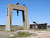
October 24, 1994 Junction of 1st Ave. and Military Rd. at Western Nebraska Community College
41°12′52″N 103°06′14″W / 41.214444°N 103.103889°WSidney 10 Wes Stevens Site August 28, 1973 Address Restricted Potter 11 Water Holes Ranch November 12, 1992 Roughly 7.5 miles west of Gurley
41°18′23″N 103°06′52″W / 41.306389°N 103.114444°WGurley 12 Wild Horse Draw-Leeman's Springs Archeological District July 12, 2006 Address Restricted Sidney See also
- List of National Historic Landmarks in Nebraska
- National Register of Historic Places listings in Nebraska
References
- ^ The latitude and longitude information provided in this table was derived originally from the National Register Information System, which has been found to be fairly accurate for about 99% of listings. For about 1% of NRIS original coordinates, experience has shown that one or both coordinates are typos or otherwise extremely far off; some corrections may have been made. A more subtle problem causes many locations to be off by up to 150 yards, depending on location in the country: most NRIS coordinates were derived from tracing out latitude and longitudes off of USGS topographical quadrant maps created under the North American Datum of 1927, which differs from the current, highly accurate WGS84 GPS system used by Google maps. Chicago is about right, but NRIS longitudes in Washington are higher by about 4.5 seconds, and are lower by about 2.0 seconds in Maine. Latitudes differ by about 1.0 second in Florida. Some locations in this table may have been corrected to current GPS standards.
- ^ "National Register of Historic Places: Weekly List Actions". National Park Service, United States Department of the Interior. Retrieved on November 10, 2011.
- ^ Numbers represent an ordering by significant words. Various colorings, defined here, differentiate National Historic Landmark sites and National Register of Historic Places Districts from other NRHP buildings, structures, sites or objects.
U.S. National Register of Historic Places Topics Lists by states Alabama • Alaska • Arizona • Arkansas • California • Colorado • Connecticut • Delaware • Florida • Georgia • Hawaii • Idaho • Illinois • Indiana • Iowa • Kansas • Kentucky • Louisiana • Maine • Maryland • Massachusetts • Michigan • Minnesota • Mississippi • Missouri • Montana • Nebraska • Nevada • New Hampshire • New Jersey • New Mexico • New York • North Carolina • North Dakota • Ohio • Oklahoma • Oregon • Pennsylvania • Rhode Island • South Carolina • South Dakota • Tennessee • Texas • Utah • Vermont • Virginia • Washington • West Virginia • Wisconsin • WyomingLists by territories Lists by associated states Other Municipalities and communities of Cheyenne County, Nebraska City 
Villages Unincorporated
communitySunol
Categories:- National Register of Historic Places in Nebraska by county
- Cheyenne County, Nebraska
- Buildings and structures in Cheyenne County, Nebraska
-


Wikimedia Foundation. 2010.