- National Register of Historic Places listings in Clarke County, Virginia
-
This list includes properties and districts listed on the National Register of Historic Places in Clarke County, Virginia. Click the "Map of all coordinates" link to the right to view a Google map of all properties and districts with latitude and longitude coordinates in the table below.[1]
-
- This National Park Service list is complete through NPS recent listings posted November 10, 2011.[2]
[3] Landmark name [4] Image Date listed Location City or town Summary 1 Annefield 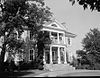
November 12, 1969 E of jct. of Rtes. 633 and 652
39°07′54″N 78°01′29″W / 39.131667°N 78.024722°WBoyce 2 Bear's Den Rural Historic District May 14, 2009 Generally runs along both side of ridge along parts of Raven Rocks and Blue Ridge Mtn. Rds. Bluemont 3 Berryville Historic District November 3, 1987 Jct. of US 7 & 340, Main, Church, & Buckmarsh Sts.
39°09′02″N 77°58′58″W / 39.150556°N 77.982778°WBerryville 4 Bethel Memorial Church February 7, 1991 Co. Rt. 622
39°01′44″N 78°02′49″W / 39.028889°N 78.046944°WWhite Post 5 Blandy Experimental Farm Historic District November 12, 1992 US 50/17 S side, 4 mi. W of the Shenandoah R.
39°03′36″N 78°03′53″W / 39.06°N 78.064722°WBoyce 6 Boyce Historic District March 8, 2004 Includes Crescent Sts., Greenway Ave., Huntingdon Ln., Main St. Old Chapel Ave., Railroad Ln., Saratoga, Virginia, and Whiting
39°05′36″N 78°03′41″W / 39.093333°N 78.061389°WBoyce 7 Burwell-Morgan Mill 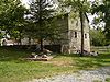
November 12, 1969 At jct. of Rtes. 723 and 255
39°04′10″N 78°02′19″W / 39.069444°N 78.038611°WMillwood 8 Carter Hall 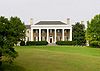
July 24, 1973 NE of Millwood off VA 255
39°04′15″N 78°01′53″W / 39.070833°N 78.031389°WMillwood 9 Chapel Hill December 30, 2004 300 Chapel Hill Ln.
39°06′49″N 78°01′14″W / 39.113611°N 78.020556°WBerryville 10 Cleridge September 8, 2011 1649 Old Charles Town Rd.
39°13′31″N 78°03′39″W / 39.225278°N 78.060833°WStephenson vicinity 11 Clermont July 27, 2005 801 E. Main St.
39°08′24″N 77°57′48″W / 39.14°N 77.963333°WBerryville 12 Cool Spring Battlefield June 6, 1997 Jct of Shenandoah R. and VA 643
39°08′01″N 77°51′59″W / 39.133611°N 77.866389°WBerryville 13 Fairfield February 26, 1970 E of jct. of Rtes. 340 and 610
39°11′05″N 77°56′08″W / 39.184722°N 77.935556°WBerryville 14 Farnley November 2, 1989 VA 658 at VA 622
39°01′41″N 78°06′50″W / 39.028056°N 78.113889°WWhite Post 15 Glendale Farm March 17, 1995 Jct. of VA 761 and VA 632, N side
39°13′49″N 78°00′44″W / 39.230278°N 78.012222°WBerryville 16 Greenway Court 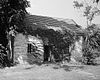
October 15, 1966 1 mi. S of White Post on VA 277
39°02′46″N 78°07′09″W / 39.046111°N 78.119167°WWhite Post Remnants of 5,000,000-acre (20,000 km2) estate of Thomas Fairfax, 6th Lord Fairfax of Cameron, only British peer in America, where George Washington worked as a surveyor 17 Greenway Historic District November 4, 1993 Roughly bounded by the Shenandoah R., the Warren Co. line, Virginia 340 and VA 618
39°03′14″N 78°03′01″W / 39.053889°N 78.050278°WBoyce Boundary increase I (listed February 21, 1997): E side of VA 255, approximately .2 mi. N of jct. with VA 723; Boundary increase II (listed October 30, 2007): 14374 Lord Fairfax Hwy. 18 Guilford February 4, 1993 VA 644 S side, 0.5 mi. W of jct. with VA 658
39°00′57″N 78°05′58″W / 39.015833°N 78.099444°WWhite Post 19 Huntingdon May 25, 1979 N of Boyce
39°06′06″N 78°03′23″W / 39.101667°N 78.056389°WBoyce 20 Josephine City School April 7, 1995 301-A Josephine St.
39°08′27″N 77°58′47″W / 39.140833°N 77.979722°WBerryville 21 Long Branch October 1, 1969 W of jct. of CR 626 and 624
39°02′34″N 78°03′21″W / 39.042778°N 78.055833°WMillwood 22 Long Marsh Run Rural Historic District November 4, 1996 Roughly bounded by WV state line, Virginia 608, Virginia 612, Virginia 7, and VA 653
39°08′55″N 77°54′38″W / 39.148611°N 77.910556°WBerryville 23 Lucky Hit August 12, 1993 VA 628 S side, 4500 ft. NE of jct. with VA 658
39°03′22″N 78°05′33″W / 39.056111°N 78.0925°WWhite Post 24 Meadea February 8, 1995 600 ft. E of jct. VA 658 and VA 628, S side
39°03′26″N 78°06′08″W / 39.057222°N 78.102222°WWhite Post 25 Millwood Colored School November 22, 2000 1610 Millwood Rd.
39°04′29″N 78°02′32″W / 39.074722°N 78.042222°WBoyce 26 Millwood Commercial Historic District January 31, 2006 Parts of Millwood Rd. and Tannery Ln.
39°04′18″N 78°02′18″W / 39.071667°N 78.038333°WMillwood 27 Norwood September 30, 1994 VA 7, S side, 7/8 mi. E of jct. with VA BR 7
39°08′26″N 77°57′01″W / 39.140556°N 77.950278°WBerryville 28 Old Chapel April 2, 1973 3 mi. N of Millwood off U.S. 340
39°06′24″N 78°00′54″W / 39.106667°N 78.015°WMillwood 29 Old Clarke County Courthouse 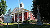
July 7, 1983 104 N. Church St.
39°09′06″N 77°58′51″W / 39.151667°N 77.980833°WBerryville 30 River House December 23, 1993 US 17/50, 2.5 mi. E of Millwood
39°02′26″N 78°00′09″W / 39.040556°N 78.0025°WMillwood 31 Saratoga 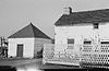
February 26, 1970 SE of jct. of Rtes. 723 and 617
39°05′05″N 78°03′33″W / 39.084722°N 78.059167°WBoyce Gray limestone Georgian house built by Brig. Gen. Daniel Morgan, best known for his victory over the British at the Battle of Cowpens in 1781. 32 Scaleby December 28, 1990 Co. Rd. 723 S of jct. with US 340
39°05′34″N 78°02′45″W / 39.092778°N 78.045833°WBoyce 33 Smithfield Farm February 16, 2001 568 Smithfield Ln.
39°10′15″N 77°54′02″W / 39.170833°N 77.900556°WBerryville 34 Soldier's Rest 
May 23, 1996 .3 mi N of Fairfax Ave., approximately .5 mi. E of jct. of US 340 and VA 7
39°09′24″N 77°58′12″W / 39.156667°N 77.97°WBerryville 35 The Tuleyries August 7, 1972 1.5 mi. E of White Post off VA 628
39°04′16″N 78°04′26″W / 39.071111°N 78.073889°WWhite Post 36 White Post Historic District September 29, 1983 VA 658 and 628
39°03′25″N 78°06′17″W / 39.056944°N 78.104722°WWhite Post 37 Wickliffe Church March 17, 1995 VA 608, E side, .5 mi. S of VA-WV line
39°09′57″N 77°53′31″W / 39.165833°N 77.891944°WBerryville See also
- National Register of Historic Places listings in Virginia
- List of National Historic Landmarks in Virginia
References
- ^ The latitude and longitude information provided in this table was derived originally from the National Register Information System, which has been found to be fairly accurate for about 99% of listings. For about 1% of NRIS original coordinates, experience has shown that one or both coordinates are typos or otherwise extremely far off; some corrections may have been made. A more subtle problem causes many locations to be off by up to 150 yards, depending on location in the country: most NRIS coordinates were derived from tracing out latitude and longitudes off of USGS topographical quadrant maps created under the North American Datum of 1927, which differs from the current, highly accurate WGS84 GPS system used by Google maps. Chicago is about right, but NRIS longitudes in Washington are higher by about 4.5 seconds, and are lower by about 2.0 seconds in Maine. Latitudes differ by about 1.0 second in Florida. Some locations in this table may have been corrected to current GPS standards.
- ^ "National Register of Historic Places: Weekly List Actions". National Park Service, United States Department of the Interior. Retrieved on November 10, 2011.
- ^ Numbers represent an ordering by significant words. Various colorings, defined here, differentiate National Historic Landmark sites and National Register of Historic Places Districts from other NRHP buildings, structures, sites or objects.
- ^ "National Register Information System". National Register of Historic Places. National Park Service. . http://nrhp.focus.nps.gov/natreg/docs/All_Data.html.
U.S. National Register of Historic Places Topics Lists by states Alabama • Alaska • Arizona • Arkansas • California • Colorado • Connecticut • Delaware • Florida • Georgia • Hawaii • Idaho • Illinois • Indiana • Iowa • Kansas • Kentucky • Louisiana • Maine • Maryland • Massachusetts • Michigan • Minnesota • Mississippi • Missouri • Montana • Nebraska • Nevada • New Hampshire • New Jersey • New Mexico • New York • North Carolina • North Dakota • Ohio • Oklahoma • Oregon • Pennsylvania • Rhode Island • South Carolina • South Dakota • Tennessee • Texas • Utah • Vermont • Virginia • Washington • West Virginia • Wisconsin • WyomingLists by territories Lists by associated states Other Municipalities and communities of Clarke County, Virginia Towns 
CDPs Shenandoah Farms‡ | Shenandoah Retreat
Unincorporated
communitiesBerrys | Bethel | Briggs | Castlemans Ferry | Claytonville | Double Tollgate | Frogtown | Gaylord | Greenway Court | Lewisville | Lockes Landing | Lost Corner | Millwood | Pigeon Hill | Pyletown | Saratoga | Stone Bridge | Stringtown | Swimley | Wadesville | Waterloo | Webbtown | White Post | Wickliffe
Footnotes ‡This populated place also has portions in an adjacent county or counties
Categories:- Clarke County, Virginia
- National Register of Historic Places in Virginia
- Virginia-related lists
-


Wikimedia Foundation. 2010.