- National Register of Historic Places listings in Clinton County, Pennsylvania
-
 Location of Clinton County in Pennsylvania
This is a list of the National Register of Historic Places listings in Clinton County, Pennsylvania.
This is intended to be a complete list of the properties and districts on the National Register of Historic Places in Clinton County, Pennsylvania, United States. The locations of National Register properties and districts for which the latitude and longitude coordinates are included below, may be seen in a Google map.[1]
There are 10 properties and districts listed on the National Register in the county.
-
- This National Park Service list is complete through NPS recent listings posted November 10, 2011.[2]
Current listings
[3] Landmark name Image Date listed Location City or town Summary 1 Farrandsville Iron Furnace September 6, 1991 Junction of Graham and Old Carrier Roads
41°10′29″N 77°30′52″W / 41.174722°N 77.514444°WColebrook Township 2 Nathan Harvey House January 3, 1985 425–427 South Water Street
41°06′36″N 77°29′06″W / 41.11°N 77.485°WMill Hall 3 Heisey House 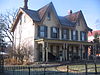
March 16, 1972 362 East Water Street
41°08′15″N 77°26′24″W / 41.1375°N 77.44°WLock Haven 4 Logan Mills Covered Bridge August 6, 1979 Southwest of Loganton over Fishing Creek
41°00′20″N 77°23′11″W / 41.005556°N 77.386389°WLogan Township 5 Logan Mills Gristmill August 11, 1980 Off Pennsylvania Route 880
41°00′23″N 77°23′01″W / 41.006389°N 77.383611°WLogan Township 6 Memorial Park Site 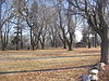
April 14, 1982 On the southern bank of the Susquehanna River near the confluence of Bald Eagle Creek
41°8′19.2″N 77°25′4.33″W / 41.138667°N 77.4178694°W[4]Lock Haven 7 Isaac A. Packer Farm 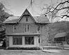
February 21, 1991 Farrandsville Road along the West Branch of the Susquehanna River
41°09′58″N 77°28′12″W / 41.166111°N 77.47°WWoodward Township 8 Ravensburg State Park 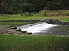
May 18, 1987 8 miles (13 km) southeast of Jersey Shore on Pennsylvania Route 880
41°06′16″N 77°14′34″W / 41.104444°N 77.242778°WCrawford Township 9 Rich-McCormick Woolen Factory September 5, 1985 Little Plum Run Road
41°10′17″N 77°22′16″W / 41.171389°N 77.371111°WDunnstable Township 10 Water Street District 
July 10, 1973 Roughly bounded by the Susquehanna River, Street Mary's Alley, Locust Avenue, and 6th Street
41°08′17″N 77°26′58″W / 41.138056°N 77.449444°WLock Haven See also
- List of National Historic Landmarks in Pennsylvania
- National Register of Historic Places listings in Pennsylvania
- List of Pennsylvania state historical markers in Clinton County
References
- ^ The latitude and longitude information provided in this table was derived originally from the National Register Information System, which has been found to be fairly accurate for about 99% of listings. For about 1% of NRIS original coordinates, experience has shown that one or both coordinates are typos or otherwise extremely far off; some corrections may have been made. A more subtle problem causes many locations to be off by up to 150 yards, depending on location in the country: most NRIS coordinates were derived from tracing out latitude and longitudes off of USGS topographical quadrant maps created under North American Datum of 1927, which differs from the current, highly accurate GPS system used by Google maps. Chicago is about right, but NRIS longitudes in Washington are higher by about 4.5 seconds, and are lower by about 2.0 seconds in Maine. Latitudes differ by about 1.0 second in Florida. Some locations in this table may have been corrected to current GPS standards.
- ^ "National Register of Historic Places: Weekly List Actions". National Park Service, United States Department of the Interior. Retrieved on November 10, 2011.
- ^ Numbers represent an ordering by significant words. Various colorings, defined here, differentiate National Historic Landmark sites and National Register of Historic Places Districts from other NRHP buildings, structures, sites or objects.
- ^ Location derived from its NRHP nomination form; the NRIS lists the site as "Address Restricted"
Municipalities and communities of Clinton County, Pennsylvania County seat: Lock Haven City 
Boroughs Avis | Beech Creek | Flemington | Loganton | Mill Hall | Renovo | South Renovo
Townships CDPs Unincorporated
communitiesKeating | Westport
Footnotes ‡This populated place also has portions in an adjacent county
Categories:- National Register of Historic Places in Pennsylvania by county
- Clinton County, Pennsylvania
-


Wikimedia Foundation. 2010.