- National Register of Historic Places listings in Cook County, Illinois
-
For places listed on the National Register in Chicago, see National Register of Historic Places listings in Chicago.
This is a list of the 112 National Register of Historic Places listings in Cook County, Illinois outside Chicago and Evanston. Separate lists are provided for the 61 listed properties and historic districts in Evanston and the 326 listed properties and districts in Chicago.
-
- This National Park Service list is complete through NPS recent listings posted November 10, 2011.[1]
Contents
Current listings
Chicago
Evanston
Other parts of Cook County
Landmark name Image Date listed Location City or Town Summary 1 Mrs. Henry F. Akin House 
May 22, 1992 901 S. 8th Ave.
41°52′46″N 87°50′31″W / 41.87944°N 87.84194°WMaywood 2 American State Bank 
October 5, 2000 6801 W. Cermak Rd.
41°51′1″N 87°47′37″W / 41.85028°N 87.79361°WBerwyn 3 Baha'i Temple 
May 23, 1978 100 Linden Ave.
42°4′27″N 87°41′3″W / 42.07417°N 87.68417°WWilmette 4 Bailey-Michelet House 
August 12, 1982 1028 Sheridan Rd.
42°4′52″N 87°41′40″W / 42.08111°N 87.69444°WWilmette (include Bailey-Michelet House link) 5 Frank J. Baker House 
November 8, 1974 507 Lake Ave.
42°4′42″N 87°41′40″W / 42.07833°N 87.69444°WWilmette (include Baker House link in article) 6 Hiram Baldwin House July 28, 1983 205 Essex Rd.
42°5′12″N 87°42′34″W / 42.08667°N 87.70944°WKenilworth 7 Nathaniel Moore Banta House 
May 20, 1998 514 N. Vail Ave.
42°5′17″N 87°59′4″W / 42.08806°N 87.98444°WArlington Heights 8 Barrington Historic District 
May 16, 1986 Roughly bounded by Chicago & Northwestern RR, S. Spring and Grove Sts., E. Hillside and W. Coolidge, and Dundee Aves.
42°9′2″N 88°8′13″W / 42.15056°N 88.13694°WBarrington 9 Berwyn Health Center 
November 21, 2002 6600 W. 26th St.
41°50′36.4″N 87°47′17″W / 41.843444°N 87.78806°WBerwyn 10 Berwyn Municipal Building 
August 8, 2001 6700 W. 26th St.
41°50′35″N 87°47′28″W / 41.84306°N 87.79111°WBerwyn 11 Bloom Township High School 
June 3, 1982 10th St., Dixie Hwy. and Chicago Heights St.
41°30′52″N 87°38′37″W / 41.51444°N 87.64361°WChicago Heights 12 Jacob Bohlander House August 21, 1989 316 N. 4th Ave.
41°53′27″N 87°50′18″W / 41.89083°N 87.83833°WMaywood 13 Mr. James Kent Calhoun House June 7, 2010 740 Greenwood Ave.
42°8′2.99″N 87°45′44.78″W / 42.1341639°N 87.7624389°WGlencoe 14 Chicago and Northwestern Depot 
April 24, 1975 1135-1141 Wilmette Ave.
42°4′39″N 87°42′20″W / 42.0775°N 87.70556°WWilmette 15 Chicago Portage National Historic Site 
October 15, 1966 S. Harlem Ave. at Chicago Sanitary and Ship Canal
41°48′39″N 87°48′28″W / 41.81083°N 87.80778°WForest View 16 George Clayson House 
March 21, 1979 224 E. Palatine Rd.
42°6′39″N 88°2′18″W / 42.11083°N 88.03833°WPalatine 17 Richard Cluever House November 17, 1977 601 N. 1st Ave.
41°53′35″N 87°50′1″W / 41.89306°N 87.83361°WMaywood 18 Community House August 30, 2007 620 Lincoln Ave.
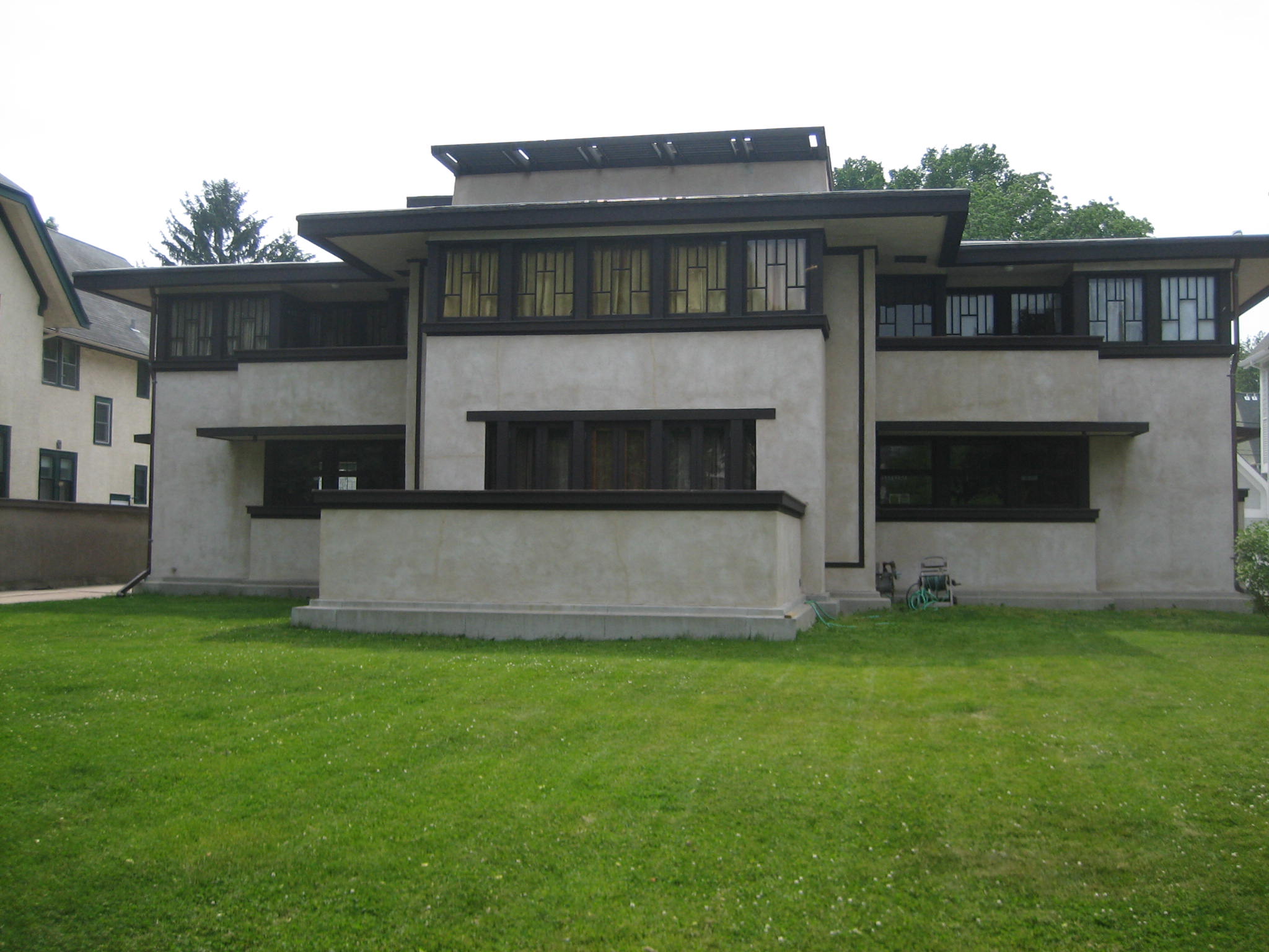
42°6′29″N 87°44′0″W / 42.10806°N 87.733333°WWinnetka 19 Avery Coonley House 
December 30, 1970 290 and 300 Scottswood Rd., 281 Bloomingbank Rd., and 336 Coonley St.
41°49′14″N 87°49′43″W / 41.82056°N 87.82861°WRiverside 20 Crow Island School October 27, 1989 1112 Willow Rd.
42°6′4″N 87°43′14″W / 42.10111°N 87.72056°WWinnetka 21 Dempster Street Station 
February 28, 1996 5001 W. Dempster St.
42°2′25″N 87°45′8″W / 42.04028°N 87.75222°WSkokie 22 Des Plaines Methodist Camp Ground 
May 22, 2005 1250 Campground Rd.
42°2′0″N 87°53′21″W / 42.033333°N 87.88917°WDes Plaines 23 Herbert A. Dilg House 
September 30, 2009 8544 Callie Ave.
42°2′13″N 87°47′2″W / 42.03694°N 87.78389°WMorton Grove 24 Dorhmann-Buckman House January 24, 1995 8455 W. Grand Ave.
41°55′45″N 87°50′16″W / 41.92917°N 87.83778°WRiver Grove 25 William E. Drummond House 
March 5, 1970 559 Edgewood Pl.
41°53′23″N 87°49′38″W / 41.88972°N 87.82722°WRiver Forest 26 Arthur J. Dunham House 
February 11, 1982 3131 S. Wisconsin Ave.
41°50′6″N 87°48′1″W / 41.835°N 87.80028°WBerwyn 27 First Congregational Church of Western Springs 
August 8, 2006 1106 Chestnut St.
41°48′53″N 87°54′11″W / 41.81472°N 87.90306°WWestern Springs 28 Flat Iron Building September 13, 2003 1441-1449 Emerald Ave.
41°30′16″N 87°38′5″W / 41.50444°N 87.63472°WChicago Heights Demolished in 2009.[2] 29 Ford Airport Hangar May 9, 1985 Glenwood-Lansing Rd. and Burnahn Ave.
41°32′33″N 87°32′18″W / 41.5425°N 87.53833°WLansing 30 William Frangenheim House May 22, 1992 410 N. 3rd Ave.
41°53′29″N 87°50′14″W / 41.89139°N 87.83722°WMaywood 31 Mrs. Thomas H. Gale House 
March 5, 1970 6 Elizabeth Ct.
41°53′31″N 87°47′54″W / 41.89194°N 87.79833°WOak Park 32 Walter Gale House 
August 17, 1973 1031 W. Chicago Ave.
41°53′38″N 87°48′7″W / 41.89389°N 87.80194°WOak Park 33 William and Caroline Gibbs House February 24, 1992 515 N. 3rd Ave.
41°53′32″N 87°50′12″W / 41.89222°N 87.83667°WMaywood 34 William A. Glasner House February 28, 2005 850 Sheridan Rd.
42°8′29″N 87°45′19″W / 42.14139°N 87.75528°WGlencoe 35 Dr. Paul W. and Eunice Greeley House February 25, 2011 545 Oak St.
42°6′17″N 87°43′31″W / 42.10472°N 87.72528°WWinnetka 36 Gross Point Village Hall 
August 5, 1991 609 Ridge Rd.
42°4′33″N 87°43′22″W / 42.07583°N 87.72278°WWilmette Home of the Wilmette Historical Museum
Gross Point Village Hall37 Grossdale Station 
June 15, 1982 8820½ Brookfield Ave.
41°49′23″N 87°50′33″W / 41.82306°N 87.8425°WBrookfield 38 Caroline Grow House May 22, 1992 603 N. 6th Ave.
41°53′34″N 87°50′25″W / 41.89278°N 87.84028°WMaywood 39 Gunderson Historic District 
March 1, 2002 Roughly bounded by Madison St., Harrison St. Gunderson St., and S. Ridgeland Ave.
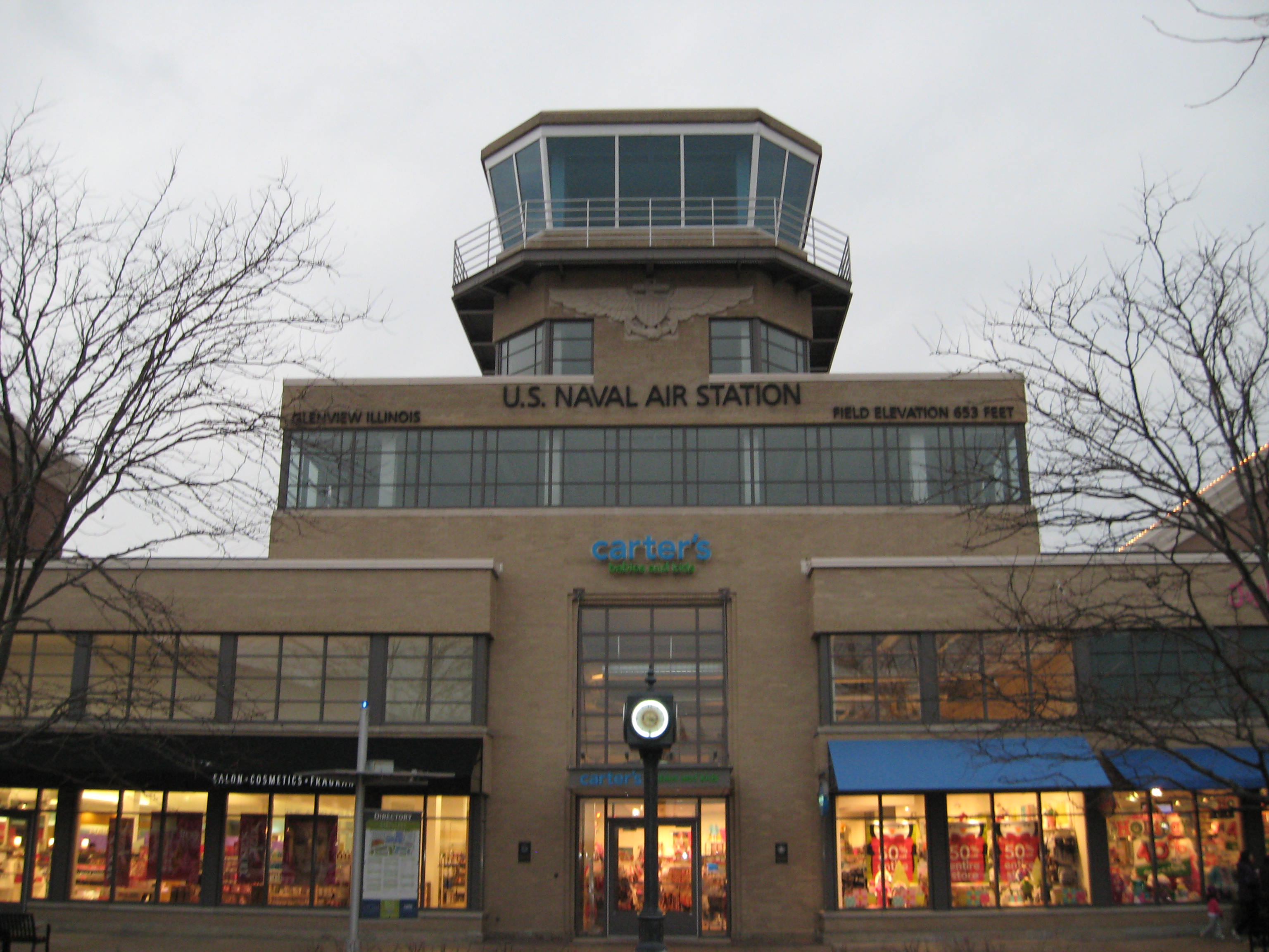
41°52′34″N 87°47′8″W / 41.87611°N 87.78556°WOak Park 40 Hangar 1, Naval Air Station-Glenview 
November 12, 1998 1901 Fourth St.
42°5′26″N 87°49′26″W / 42.09056°N 87.82389°WGlenview 41 Harrer Building 
February 17, 1983 8051 N. Lincoln Ave.
42°1′39″N 87°45′14″W / 42.0275°N 87.75389°WSkokie 42 William H. Hatch House 
September 5, 2007 309 Keystone Ave.
41°53′12″N 87°49′5″W / 41.88667°N 87.81806°WRiver Forest 43 Haymarket Martyrs' Monument 
February 18, 1997 863 S. Des Plaines Ave.
41°52′12″N 87°49′20″W / 41.87°N 87.82222°WForest Park 44 Arthur Heurtley House 
February 16, 2000 318 N. Forest Avenue
41°53′35″N 87°48′1″W / 41.89306°N 87.80028°WOak Park 45 Dr. Robert Hohf House December 12, 2008 303 Sheridan Rd.
42°5′30.89″N 87°42′25.39″W / 42.0919139°N 87.7070528°WKenilworth vicinity 46 Hofmann Tower 
December 22, 1978 3910 Barry Point Rd.
41°49′14″N 87°49′19″W / 41.82056°N 87.82194°WLyons 47 John Humphrey House 
August 1, 2005 9830 W. 144th Pl.
41°37′48″N 87°51′34″W / 41.63°N 87.85944°WOrland Park 48 Illinois Industrial School for Girls 
August 6, 1998 733 N. Prospect Ave.
42°1′18″N 87°49′40″W / 42.02167°N 87.82778°WPark Ridge Currently the Youth Campus, administered by Maine Twp. H.S. Dist. 207 49 Kenilworth Club March 21, 1979 410 Kenilworth Ave.
42°5′11″N 87°42′57″W / 42.08639°N 87.71583°WKenilworth 50 Kennicott's Grove 
August 13, 1973 Milwaukee and Lake Aves.
42°4′53″N 87°51′30″W / 42.08139°N 87.85833°WGlenview 51 La Grange Village Historic District 
August 8, 1979 U.S. 12
41°48′37″N 87°52′22″W / 41.81028°N 87.87278°WLa Grange 52 Mads C. Larson House May 22, 1992 318 S. 1st Ave.
41°53′5″N 87°50′5″W / 41.88472°N 87.83472°WMaywood 53 Lemont Central Grade School 
March 7, 1975 410 McCarthy Rd.
41°40′21″N 87°59′50″W / 41.6725°N 87.99722°WLemont 54 Lemont Methodist Episcopal Church 
May 5, 1986 306 Lemont St.
41°40′23″N 88°0′0″W / 41.67306°N 88°WLemont 55 Linden Avenue Terminal 
February 8, 1984 330 Linden Ave.
42°4′25″N 87°41′30″W / 42.07361°N 87.69167°WWilmette 56 Henry Demarest Lloyd House 
November 13, 1966 830 Sheridan Rd.
42°6′51″N 87°43′56″W / 42.11417°N 87.73222°WWinnetka NHL name is The Wayside 57 Timothy J. Lynch House February 24, 1992 416 N. 4th Ave.
41°53′29″N 87°50′18″W / 41.89139°N 87.83833°WMaywood 58 Lyons Township Hall 
November 30, 1978 53 S. LaGrange Rd.
41°48′50″N 87°52′9″W / 41.81389°N 87.86917°WLa Grange Known as the LaGrange Village Hall 59 George W. Maher House March 21, 1979 424 Warwick Rd.
42°5′24″N 87°42′47″W / 42.09°N 87.71306°WKenilworth 60 Marshall Field and Company Store 
January 21, 1988 1144 W. Lake St.
41°53′21″N 87°48′16″W / 41.88917°N 87.80444°WOak Park 61 Masonic Temple Building May 22, 1992 200 S. 5th Ave.
41°53′9″N 87°50′22″W / 41.88583°N 87.83944°WMaywood 62 Masonic Temple Building 
February 11, 1982 119-137 N. Oak Park Ave.
41°53′17″N 87°47′41″W / 41.88806°N 87.79472°WOak Park 63 Lola Maverick Lloyd House February 1, 2006 455 Birch St.
42°6′21″N 87°44′12″W / 42.10583°N 87.73667°WWinnetka 64 Maywood Fire Department Building May 22, 1992 511 St. Charles Rd.
41°53′17″N 87°50′24″W / 41.88806°N 87.84°WMaywood 65 William McJunkin House March 2, 2006 151 Sheridan Rd. Winnetka 66 Caroline Millward House May 22, 1992 502 N. 5th Ave.
41°53′31″N 87°50′22″W / 41.89194°N 87.83944°WMaywood 67 John Rogerson Montgomery House September 15, 2004 15 Old Green Bay Rd.
42°7′20″N 87°44′32″W / 42.12222°N 87.74222°WGlencoe 68 J. Sterling Morton High School East Auditorium 
May 9, 1983 2423 S. Austin Blvd.
41°50′47″N 87°46′23″W / 41.84639°N 87.77306°WCicero 69 Muller House 
March 26, 1979 500 N. Vail Ave.
42°5′15″N 87°59′4″W / 42.0875°N 87.98444°WArlington Heights 70 Harry H. Nichols House February 24, 1992 216 S. 4th Ave.
41°53′8″N 87°50′17″W / 41.88556°N 87.83806°WMaywood 71 Mr. J. William de Coursey O'Grady House December 12, 2008 149 Kenilworth Ave.
42°5′29.3″N 87°42′42.75″W / 42.091472°N 87.711875°WKenilworth 72 Oak Circle Historic District 
June 21, 2001 318-351 Oak Circle
42°4′20″N 87°42′39″W / 42.07222°N 87.71083°WWilmette 73 Oak Lawn School November 2, 1990 9526 S. Cook Ave.
41°43′8″N 87°45′7″W / 41.71889°N 87.75194°WOak Lawn Demolished in 2003.[3] 74 Oak Park Conservatory 
March 8, 2005 615 Garfield St.
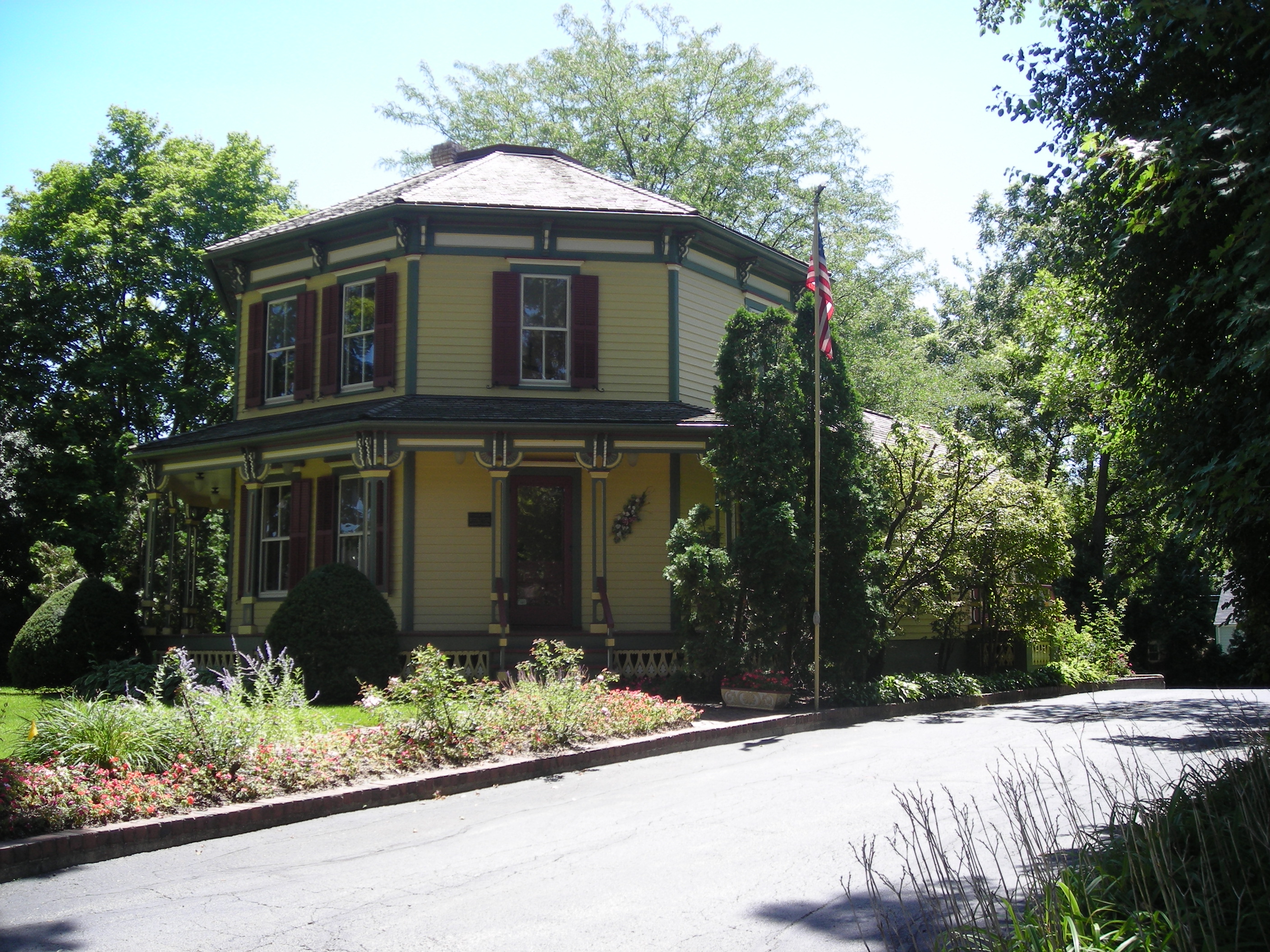
41°52′18″N 87°47′23″W / 41.87167°N 87.78972°WOak Park 75 Octagon House 
March 21, 1979 223 W. Main St.
42°9′14″N 88°8′20″W / 42.15389°N 88.13889°WBarrington 76 Olympia Fields Country Club February 9, 2001 2800 Country Club Dr.
41°30′57″N 87°41′6″W / 41.51583°N 87.685°WOlympia Fields 77 Orth House October 8, 1976 42 Abbotsford Rd.
42°5′31″N 87°43′10″W / 42.09194°N 87.71944°WWinnetka 78 Ouilmette North Historic District 
December 6, 2005 46 blocks: Chesnut Ave, Sheridan Road, Lake Ave. and 13th St.
42°4′55″N 87°42′3″W / 42.08194°N 87.70083°WWilmette Named for Antoine Ouilmette (1760–1841) 79 Pacesetter Gardens Historic District November 16, 2005 13604-13736 S. Lowe Ave.
41°38′48″N 87°38′14″W / 41.64667°N 87.63722°WRiverdale 80 Charles H. Patten House 
November 8, 2006 117 N. Benton St.
42°6′45″N 88°2′28″W / 42.1125°N 88.04111°WPalatine 81 Pickwick Theater Building 
February 24, 1975 5 S. Prospect Ave.
42°0′38″N 87°49′45″W / 42.01056°N 87.82917°WPark Ridge 82 Pleasant Home 
June 19, 1972 217 Home Ave.
41°53′8.4″N 87°48′0.1″W / 41.885667°N 87.800028°WOak Park NHL name is John Farson House 83 George E. Purple House 
August 12, 2005 338 Sunset Ave.
41°48′36″N 87°53′2″W / 41.81°N 87.88389°WLaGrange 84 Charles N. Ramsey and Herry E. Weese House April 1, 2009 141 Kenilworth Avenue
42°5′30.33″N 87°42′39.28″W / 42.0917583°N 87.7109111°WKenilworth 85 Ridgeland-Oak Park Historic District 
December 8, 1983 Roughly bounded by Austin Blvd., Harlem, Ridgeland, and Chicago Aves., Lake and Madison Sts.
41°53′7″N 87°47′18″W / 41.88528°N 87.78833°WOak Park 86 River Forest Historic District 
August 26, 1977 Between Harlem Ave. and Des Plaines River with 2 extensions N of Chicago Ave. and 2 extensions S of Lake St.
41°53′31″N 87°49′9″W / 41.89194°N 87.81917°WRiver Forest 87 Riverside Landscape Architecture District 
September 15, 1969 Bounded by 26th St., Harlem and Ogden Aves., the Des Plaines River, and Forbes Rd.
41°49′39″N 87°49′15″W / 41.8275°N 87.82083°WRiverside NHL name is Riverside Historic District 88 Robinson House February 24, 1992 602 N. 3rd Ave.
41°53′35″N 87°50′14″W / 41.89306°N 87.83722°WMaywood 89 Root-Badger House May 19, 1992 326 Essex Rd.[4]
42°5′17″N 87°42′46″W / 42.08806°N 87.71278°WKenilworth 90 St. James Catholic Church and Cemetery 
August 16, 1984 106th St. and Archer Ave.
41°41′55″N 87°55′57″W / 41.69861°N 87.9325°WLemont 91 Paul Schweikher House and Studio February 17, 1987 645 S. Meacham Rd.
42°0′51″N 88°2′36″W / 42.01417°N 88.04333°WSchaumburg 92 Scoville Place 
November 21, 2002 Jct. of Lake St. and Oak Park Ave.
41°53′23″N 87°47′42″W / 41.88972°N 87.795°WOak Park 93 Mr. Robert Silhan House 
February 20, 2007 3728 S. Cuyler Ave.
41°49′28″N 87°46′53″W / 41.82444°N 87.78139°WBerwyn 94 Albert Soffel House May 22, 1992 508 N. 5th Ave.
41°53′32″N 87°50′23″W / 41.89222°N 87.83972°WMaywood 95 Joseph P. O. Sullivan House May 22, 1992 142 S. 17th Ave.
41°53′14″N 87°50′33″W / 41.88722°N 87.8425°WMaywood 96 Sunderlage Farm Smokehouse 
February 20, 1990 1775 Vista Walk
42°3′5″N 88°7′24″W / 42.05139°N 88.12333°WHoffman Estates 97 Sylvan Road Bridge 
June 23, 1978 Sylvan Rd.
42°8′40″N 87°45′48″W / 42.14444°N 87.76333°WGlencoe Demolished.[5] 98 Frank Thomas House 
September 14, 1972 210 Forest Ave.
41°53′28″N 87°47′48″W / 41.89111°N 87.79667°WOak Park 99 Jennie S. Thompkins House May 22, 1992 503 N. 4th Ave.
41°53′28″N 87°50′23″W / 41.89111°N 87.83972°WMaywood 100 George R. Thorne House 
May 2, 1997 7 Cottage Row
41°37′58″N 87°45′3″W / 41.63278°N 87.75083°WMidlothian 101 F.F. Tomek House 
January 20, 1999 150 Nuttall Road
41°49′56″N 87°49′2″W / 41.83222°N 87.81722°WRiverside 102 Twin Tower Sanctuary 
November 16, 1988 9967 W. 144th St.
41°37′43″N 87°51′46″W / 41.62861°N 87.86278°WOrland Park 103 Unity Temple 
April 17, 1970 875 Lake St.
41°53′18″N 87°47′48″W / 41.88833°N 87.79667°WOak Park 104 Robert Vial House 
August 31, 2007 7425 S. Wolf Rd.
41°45′17″N 87°53′45″W / 41.75472°N 87.89583°WBurr Ridge 105 Karl Vogt Building 
January 21, 1988 6811 Hickory St.
41°34′29″N 87°47′4″W / 41.57472°N 87.78444°WTinley Park 106 Western Springs Water Tower 
June 4, 1981 914 Hillgrove Ave.
41°48′35″N 87°54′3″W / 41.80972°N 87.90083°WWestern Springs 107 Wheeler-Magnus Round Barn 
August 18, 1992 811 E. Central Rd.
42°3′53″N 87°58′19″W / 42.06472°N 87.97194°WArlington Heights 108 Wild Flower and Bird Sanctuary in Mahoney Park April 10, 1985 Sheridan Rd..
42°5′21″N 87°42′12″W / 42.08917°N 87.70333°WKenilworth 109 William H. Winslow House and Stable 
April 17, 1970 515 Auvergne Pl.
41°53′19″N 87°49′44″W / 41.88861°N 87.82889°WRiver Forest 110 Frank Lloyd Wright House and Studio 
September 14, 1972 428 Forest Ave. (house), 951 Chicago Ave. (studio)
41°53′39″N 87°48′0″W / 41.89417°N 87.8°WOak Park 111 Frank Lloyd Wright-Prairie School of Architecture Historic District 
December 4, 1973 Bounded roughly by Harlem Ave., Division, Clyde, and Lake Sts.
41°53′37″N 87°47′32″W / 41.89361°N 87.79222°WOak Park Boundary increase to include Cuyler Ave (May 22, 2009) 112 Joshua P. Young House 
August 12, 1982 2445 High St.
41°39′9″N 87°40′30″W / 41.6525°N 87.675°WBlue Island built c. 1852, home of influential mid-nineteenth century developer of Chicago's south side and southern suburbs. Key
NRHP-listed ∞ NRHP-listed Historic district * National Historic Landmark and NRHP-listed ∞ National Historic Landmark and NRHP-listed Historic district See also
- List of Chicago Landmarks
- National Register of Historic Places listings in Chicago
- National Register of Historic Places listings in Illinois
- List of National Historic Landmarks in Illinois
References
- ^ "National Register of Historic Places: Weekly List Actions". National Park Service, United States Department of the Interior. Retrieved on November 10, 2011.
- ^ James W. Wright. The Dixie Highway in Illinois. Arcadia, 2009. 50.
- ^ http://www.lib.oak-lawn.il.us/MINUTES/pd030210.pdf
- ^ http://www.landmarks.org/chicago_watch_2004_9.htm Landmarks Preservation Council of Illinois: 2004 Chicagoland Watch List
- ^ http://gis.hpa.state.il.us/hargis/ Search by National Register, City: Glencoe
External links
- National Register Information System[dead link], National Park Service.
U.S. National Register of Historic Places Topics Lists by states Alabama • Alaska • Arizona • Arkansas • California • Colorado • Connecticut • Delaware • Florida • Georgia • Hawaii • Idaho • Illinois • Indiana • Iowa • Kansas • Kentucky • Louisiana • Maine • Maryland • Massachusetts • Michigan • Minnesota • Mississippi • Missouri • Montana • Nebraska • Nevada • New Hampshire • New Jersey • New Mexico • New York • North Carolina • North Dakota • Ohio • Oklahoma • Oregon • Pennsylvania • Rhode Island • South Carolina • South Dakota • Tennessee • Texas • Utah • Vermont • Virginia • Washington • West Virginia • Wisconsin • WyomingLists by territories Lists by associated states Other Categories:- NRHP articles with dead external links
- National Register of Historic Places in Cook County, Illinois
-


Wikimedia Foundation. 2010.