- National Register of Historic Places listings in Crawford County, Iowa
-
 Location of Crawford County in Iowa
This is a list of the National Register of Historic Places listings in Crawford County, Iowa.
This is intended to be a complete list of the properties and districts on the National Register of Historic Places in Crawford County, Iowa, United States. Latitude and longitude coordinates are provided for many National Register properties and districts; these locations may be seen together in a Google map.[1]
There are 14 properties listed on the National Register in the county.
-
- This National Park Service list is complete through NPS recent listings posted November 10, 2011.[2]
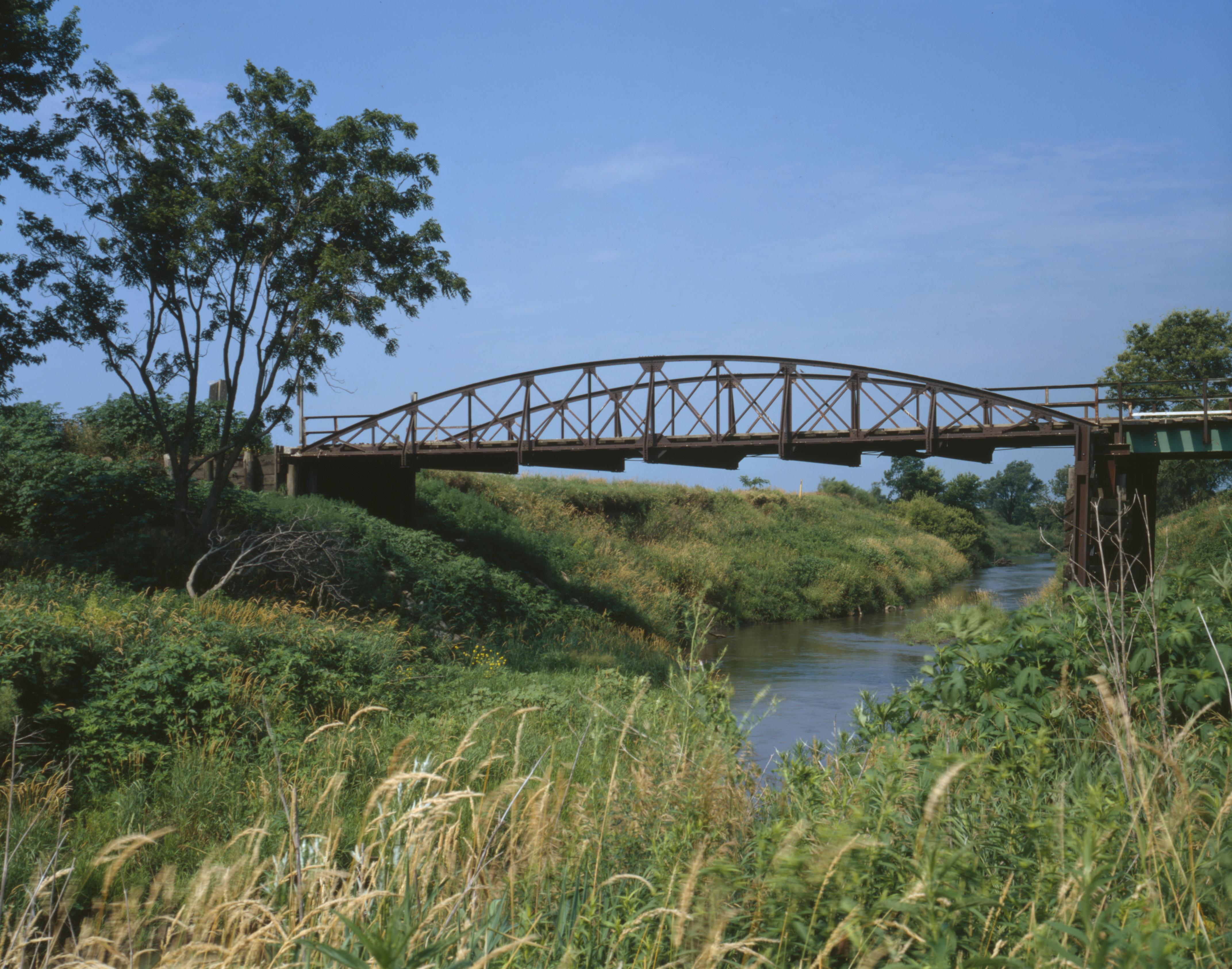
[3] Landmark name [4] Image Date listed Location City or town Summary 1 Beaver Creek Bridge June 25, 1998 180th St. between B and C Aves. over Beaver Creek
42°11′48″N 95°30′54″W / 42.196667°N 95.515°WSchleswig 2 Buck Grove Bridge June 25, 1998 Buck Creek Ave. over Buck Creek
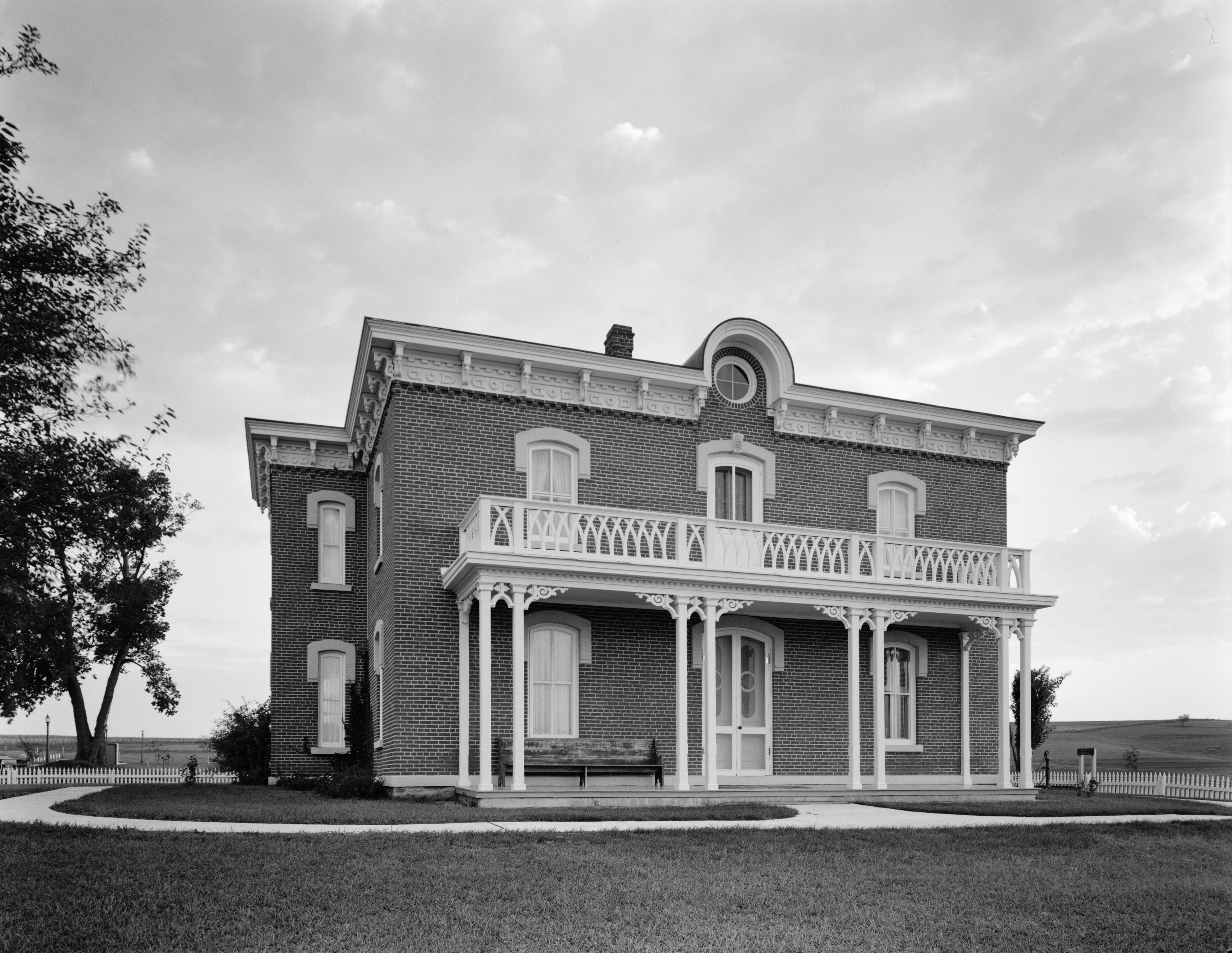
41°54′50″N 95°22′49″W / 41.913889°N 95.380278°WBuck Grove 3 John T. and Marietta (Greek) Carey House 
April 11, 2005 1502 1st Ave., N.
42°01′03″N 95°21′06″W / 42.0175°N 95.351667°WDenison Designed by architect George Franklin Barber 4 Clarence D. Chamberlin House 
April 28, 1977 1434 2nd Ave., S.
42°00′53″N 95°21′07″W / 42.014722°N 95.351944°WDenison 5 Crawford County Courthouse 
July 2, 1981 Broadway between Ave. B and Ave. C Denison 6 Dow House 
June 14, 1972 Prince St. at the southern city limit
41°55′30″N 95°29′50″W / 41.925°N 95.497222°WDow City 7 Z.T. Dunham Pioneer Stock Farm August 2, 1993 Iowa Highway 37, 1 mile northwest of Dunlap
41°52′03″N 95°37′09″W / 41.8675°N 95.619167°WDunlap 8 East Soldier River Bridge June 25, 1998 120th St. over the East Soldier River
42°03′28″N 95°38′01″W / 42.057778°N 95.633611°WCharter Oak 9 Klondike Hotel October 3, 1996 332 3rd St.
41°53′26″N 95°14′03″W / 41.890556°N 95.234167°WManilla 10 William A. McHenry House 
November 7, 1976 1428 1st Ave., N.
42°01′05″N 95°21′07″W / 42.018056°N 95.351944°WDenison 11 Nishnabotna River Bridge (310th Street) 
March 12, 1999 310th St. between X and Y Aves.
41°52′00″N 95°16′00″W / 41.866667°N 95.266667°WManilla 12 Nishnabotna River Bridge (T Avenue) June 25, 1998 T Ave. over the Nishnabotna River
41°56′08″N 95°13′08″W / 41.935556°N 95.218889°WManilla 13 Park Motel 
June 2, 2000 803 4th Ave. S.
42°00′43″N 95°21′45″W / 42.011944°N 95.3625°WDenison 14 Yellow Smoke Park Bridge June 25, 1998 Pedestrian path over an unnamed stream
42°00′31″N 95°19′38″W / 42.008611°N 95.327222°WDenison See also
References
- ^ The latitude and longitude information provided in this table was derived originally from the National Register Information System, which has been found to be fairly accurate for about 99% of listings. For about 1% of NRIS original coordinates, experience has shown that one or both coordinates are typos or otherwise extremely far off; some corrections may have been made. A more subtle problem causes many locations to be off by up to 150 yards, depending on location in the country: most NRIS coordinates were derived from tracing out latitude and longitudes off of USGS topographical quadrant maps created under the North American Datum of 1927, which differs from the current, highly accurate WGS84 GPS system used by Google maps. Chicago is about right, but NRIS longitudes in Washington are higher by about 4.5 seconds, and are lower by about 2.0 seconds in Maine. Latitudes differ by about 1.0 second in Florida. Some locations in this table may have been corrected to current GPS standards.
- ^ "National Register of Historic Places: Weekly List Actions". National Park Service, United States Department of the Interior. Retrieved on November 10, 2011.
- ^ Numbers represent an ordering by significant words. Various colorings, defined here, differentiate National Historic Landmark sites and National Register of Historic Places Districts from other NRHP buildings, structures, sites or objects.
- ^ "National Register Information System". National Register of Historic Places. National Park Service. . http://nrhp.focus.nps.gov/natreg/docs/All_Data.html.
U.S. National Register of Historic Places Topics Lists by states Alabama • Alaska • Arizona • Arkansas • California • Colorado • Connecticut • Delaware • Florida • Georgia • Hawaii • Idaho • Illinois • Indiana • Iowa • Kansas • Kentucky • Louisiana • Maine • Maryland • Massachusetts • Michigan • Minnesota • Mississippi • Missouri • Montana • Nebraska • Nevada • New Hampshire • New Jersey • New Mexico • New York • North Carolina • North Dakota • Ohio • Oklahoma • Oregon • Pennsylvania • Rhode Island • South Carolina • South Dakota • Tennessee • Texas • Utah • Vermont • Virginia • Washington • West Virginia • Wisconsin • WyomingLists by territories Lists by associated states Other Municipalities and communities of Crawford County, Iowa Cities 
Townships Boyer | Charter Oak | Denison | East Boyer | Goodrich | Hanover | Hayes | Iowa | Jackson | Milford | Morgan | Nishnabotny | Otter Creek | Paradise | Soldier | Stockholm | Union | Washington | West Side | Willow
Footnotes ‡This populated place also has portions in an adjacent county or counties
Categories:- National Register of Historic Places in Iowa by county
- Crawford County, Iowa
- Buildings and structures in Crawford County, Iowa
-


Wikimedia Foundation. 2010.