- National Register of Historic Places listings in Cross County, Arkansas
-
 Location of Cross County in Arkansas
This is a list of the National Register of Historic Places listings in Cross County, Arkansas.
This is intended to be a complete list of the properties and districts on the National Register of Historic Places in Cross County, Arkansas, United States. The locations of National Register properties and districts for which the latitude and longitude coordinates are included below, may be seen in a Google map.[1]
There are 16 properties and districts listed on the National Register in the county, including 1 National Historic Landmark.
Contents: Counties in Arkansas Arkansas - Ashley - Baxter - Benton - Boone - Bradley - Calhoun - Carroll - Chicot - Clark - Clay - Cleburne - Cleveland - Columbia - Conway - Craighead - Crawford - Crittenden - Cross - Dallas - Desha - Drew - Faulkner - Franklin - Fulton - Garland - Grant - Greene - Hempstead - Hot Spring - Howard - Independence - Izard - Jackson - Jefferson - Johnson - Lafayette - Lawrence - Lee - Lincoln - Little River - Logan - Lonoke - Madison - Marion - Miller - Mississippi - Monroe - Montgomery - Nevada - Newton - Ouachita - Perry - Phillips - Pike - Poinsett - Polk - Pope - Prairie - Pulaski (Little Rock) - Randolph - St. Francis - Saline - Scott - Searcy - Sebastian - Sevier - Sharp - Stone - Union - Van Buren - Washington - White - Woodruff - Yell
-
- This National Park Service list is complete through NPS recent listings posted November 10, 2011.[2]
Current listings
[3] Landmark name [4] Image Date listed Location City or town Summary 1 Isaac Block House July 15, 1998 404 E. Hamilton St.
35°13′35″N 90°47′19″W / 35.226389°N 90.788611°WWynne 2 Capt. Isaac N. Deadrick House September 16, 1993 Northwest of the junction of U.S. Route 64 and Highway 163
35°15′02″N 90°42′44″W / 35.250556°N 90.712222°WLevesque 3 East Hamilton Avenue Historic District June 8, 2011 E. Hamilton Ave. between N. Falls Blvd. & N. Killough Rd.; Eldridge Ct.
35°13′31″N 90°48′51″W / 35.225278°N 90.814167°WWynne 4 Giboney-Robertson-Stewart House June 5, 1998 734 Hamilton Ave.
35°13′32″N 90°47′05″W / 35.225556°N 90.784722°WWynne 5 Grace Episcopal Church March 5, 1992 614 E. Poplar St.
35°13′40″N 90°47′12″W / 35.227778°N 90.786667°WWynne 6 John H. Johnston Cotton Gin Historic District June 1, 2005 Junction of U.S. Route 64 and Highway 163
35°15′01″N 90°42′48″W / 35.250278°N 90.713333°WLevesque 7 Memphis to Little Rock Road-Village Creek Segment April 11, 2003 East of Lake Austell within Village Creek State Park
35°08′48″N 90°43′00″W / 35.146667°N 90.716667°WNewcastle A segment of the Trail of Tears 8 New Hope School November 12, 2008 3762 Highway 284
35°12′26″N 90°43′56″W / 35.207139°N 90.732144°WWynne 9 Parkin Indian Mound 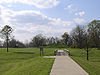
October 15, 1966 Junction of U.S. Route 64 and Highway 184
35°16′37.7″N 90°33′26.66″W / 35.277139°N 90.5574056°W[5]Parkin 10 South Elementary School May 24, 2006 711 E. Union Ave.
35°13′31″N 90°47′09″W / 35.225278°N 90.785833°WWynne 11 Wittsburg Fortification December 31, 2002 Address Restricted Wittsburg 12 Wittsburg Store and Gas Station November 22, 2000 County Road 739
35°13′05″N 90°42′00″W / 35.218056°N 90.7°WWittsburg 13 Woman's Progressive Club March 27, 1990 Rowena St. and Merriman Ave.
35°13′25″N 90°47′21″W / 35.223611°N 90.789167°WWynne 14 Wynne Commercial Historic District December 22, 2009 Roughly bounded by Front St., Commercial Ave., Terry St., Wilson St., and Pecan Ave.
35°13′23″N 90°47′30″W / 35.223172°N 90.791717°WWynne 15 Wynne Post Office August 14, 1998 402 E. Merriman Ave.
35°13′27″N 90°47′21″W / 35.224167°N 90.789167°WWynne 16 Wynne Wholesale Commercial Historic District January 25, 2010 Corner of W. Merriman and Martin Luther King Dr.
35°13′28″N 90°47′38″W / 35.224536°N 90.793917°WWynne See also
- List of National Historic Landmarks in Arkansas
- National Register of Historic Places listings in Arkansas
References
- ^ The latitude and longitude information provided in this table was derived originally from the National Register Information System, which has been found to be fairly accurate for about 99% of listings. For about 1% of NRIS original coordinates, experience has shown that one or both coordinates are typos or otherwise extremely far off; some corrections may have been made. A more subtle problem causes many locations to be off by up to 150 yards, depending on location in the country: most NRIS coordinates were derived from tracing out latitude and longitudes off of USGS topographical quadrant maps created under the North American Datum of 1927, which differs from the current, highly accurate WGS84 GPS system used by Google maps. Chicago is about right, but NRIS longitudes in Washington are higher by about 4.5 seconds, and are lower by about 2.0 seconds in Maine. Latitudes differ by about 1.0 second in Florida. Some locations in this table may have been corrected to current GPS standards.
- ^ "National Register of Historic Places: Weekly List Actions". National Park Service, United States Department of the Interior. Retrieved on November 10, 2011.
- ^ Numbers represent an ordering by significant words. Various colorings, defined here, differentiate National Historic Landmark sites and National Register of Historic Places Districts from other NRHP buildings, structures, sites or objects.
- ^ "National Register Information System". National Register of Historic Places. National Park Service. . http://nrhp.focus.nps.gov/natreg/docs/All_Data.html.
- ^ Location derived from this Parkin Archeological State Park webpage; the NRIS lists the site as "Address Restricted".
U.S. National Register of Historic Places Topics Lists by states Alabama • Alaska • Arizona • Arkansas • California • Colorado • Connecticut • Delaware • Florida • Georgia • Hawaii • Idaho • Illinois • Indiana • Iowa • Kansas • Kentucky • Louisiana • Maine • Maryland • Massachusetts • Michigan • Minnesota • Mississippi • Missouri • Montana • Nebraska • Nevada • New Hampshire • New Jersey • New Mexico • New York • North Carolina • North Dakota • Ohio • Oklahoma • Oregon • Pennsylvania • Rhode Island • South Carolina • South Dakota • Tennessee • Texas • Utah • Vermont • Virginia • Washington • West Virginia • Wisconsin • WyomingLists by territories Lists by associated states Other Municipalities and communities of Cross County, Arkansas Cities 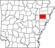
Unincorporated
communitiesFair Oaks | Twist | Vanndale | Wilkins
Categories:- Cross County, Arkansas
- National Register of Historic Places in Arkansas by county
-


Wikimedia Foundation. 2010.