- National Register of Historic Places listings in Cuyahoga County, Ohio
-
 Location of Cuyahoga County in Ohio
This is a list of the National Register of Historic Places listings in Cuyahoga County, Ohio.
This is intended to be a complete list of the properties and districts on the National Register of Historic Places in Cuyahoga County, Ohio, United States. Latitude and longitude coordinates are provided for many National Register properties and districts; these locations may be seen together in a Google map.[1]
There are 351 properties and districts listed on the National Register in the county, including 4 National Historic Landmarks. 136 of these properties and districts, including 1 National Historic Landmark, are located outside of Cleveland, and are listed here, while the properties and districts in Cleveland are listed separately. Three properties and districts are split between Cleveland and other parts of the county, and are thus included on both lists.
-
- This National Park Service list is complete through NPS recent listings posted November 10, 2011.[2]
Current listings
Cleveland
Exclusive of Cleveland
[3] Landmark name [4] Image Date listed Location City or town Summary 1 John and Maria Adams House October 10, 1975 7315 Columbia Rd.
41°23′02″N 81°54′11″W / 41.383911°N 81.903014°WOlmsted Falls 2 Alcazar Hotel 
April 17, 1979 Surrey and Derbyshire Rds.
41°30′07″N 81°35′34″W / 41.501944°N 81.592778°WCleveland Heights 3 Aaron Aldrich House December 4, 1978 30663 Lake Rd.
41°29′49″N 81°57′32″W / 41.496944°N 81.958889°WBay Village 4 Ambler Heights Historic District August 22, 2002 Roughly bounded by Martin Luther King, Jr. Boulevard, Cedar Glen, N. Park Boulevard, and along Harcourt Dr.
41°29′50″N 81°36′04″W / 41.497219°N 81.601111°WCleveland Heights 5 John M. Annis House 
March 19, 1992 9271 State Rd.
41°20′31″N 81°43′28″W / 41.341944°N 81.724444°WNorth Royalton 6 Baldwin-Wallace College South Campus Historic District 
June 7, 2010 Seminary St. between School St. and Church St., Front St. to Beach St., variable west/east boundary
41°22′05″N 81°51′06″W / 41.368025°N 81.851575°WBerea 7 Bay View Hospital August 27, 1974 23200 Lake Rd.
41°28′56″N 81°52′36″W / 41.482222°N 81.876667°WBay Village 8 Bedford Baptist Church 
December 27, 2002 750 Broadway Ave.
41°23′24″N 81°32′03″W / 41.39°N 81.534167°WBedford 9 Bedford Historic District July 14, 2004 Roughly bounded by Willis St., Franklin St., Broadway Ave., and Columbus Rd.
41°23′27″N 81°32′06″W / 41.390833°N 81.535°WBedford 10 Bedford Township Hall 
May 27, 1975 30 South Park St.
41°23′24″N 81°32′05″W / 41.389933°N 81.534683°WBedford 11 Berea District 7 School 
April 3, 1975 323 E. Bagley Rd.
41°22′22″N 81°50′29″W / 41.372778°N 81.841389°WBerea 12 Berea Union Depot 
November 21, 1980 30 Depot St.
41°22′52″N 81°51′16″W / 41.381111°N 81.854444°WBerea 13 Birdtown Historic District June 27, 2007 Roughly bounded by Magee Rd., Plover Rd., Halstead Rd., and Madison Ave.
41°28′30″N 81°46′35″W / 41.475125°N 81.776433°WLakewood 14 Elizabeth B. Blossom Subdivision Historic District September 22, 1987 Junction of Richmond and Cedar Rds.
41°29′59″N 81°30′31″W / 41.499722°N 81.508611°WBeachwood 15 Elizabeth B. and Dudley S. Blossom Estate Service Compound February 20, 2004 24449 Cedar Rd.
41°30′06″N 81°30′22″W / 41.501667°N 81.506111°WLyndhurst 16 Chester and Frances Bolton House March 29, 1984 1950 Richmond Rd.
41°30′27.9″N 81°30′13.5″W / 41.50775°N 81.50375°W[5]Lyndhurst 17 Brecksville Town Hall July 2, 1973 Public Sq.
41°19′14″N 81°37′36″W / 41.320556°N 81.626667°WBrecksville 18 Brecksville Trailside Museum August 14, 1992 Chippewa Cr. Dr. southeast of its junction with State Route 82
41°19′03″N 81°36′44″W / 41.3175°N 81.612222°WBrecksville 19 John Hartness Brown House November 7, 1976 2380 Overlook Rd.
41°30′24″N 81°35′43″W / 41.506667°N 81.595278°WCleveland Heights 20 Buehl House 
April 30, 1976 118 E. Bridge St.
41°21′58″N 81°50′59″W / 41.366111°N 81.849722°WBerea 21 Harold B. Burdick House 
September 17, 1974 2424 Stratford Rd.
41°29′36″N 81°34′17″W / 41.493333°N 81.571389°WCleveland Heights 22 William Burt House March 22, 1979 9525 Brecksville Rd.
41°18′10″N 81°37′36″W / 41.302778°N 81.626667°WBrecksville 23 Chagrin Falls Township Hall October 1, 1974 83 N. Main St.
41°25′54″N 81°23′34″W / 41.431667°N 81.392778°WChagrin Falls 24 Chagrin Falls Triangle Park Commercial District December 29, 1978 Main, Franklin, and Washington Sts.; also at the junction of N. Main and E. Orange Sts., extending east and south
41°25′50″N 81°23′31″W / 41.430556°N 81.391944°WChagrin Falls Second set of boundaries represents a boundary increase 25 Chagrin Falls West Side District October 9, 1974 Bounded by W. Washington, Church, Maple, and Franklin Sts.
41°25′45″N 81°23′43″W / 41.429167°N 81.395278°WChagrin Falls 26 Clague House January 11, 1976 1371 Clague Rd.
41°28′00″N 81°52′55″W / 41.466667°N 81.881944°WWestlake 27 Jared Clark House August 1, 1975 6241 Wallings Rd.
41°20′43″N 81°38′36″W / 41.345278°N 81.643333°WBroadview Heights 28 Cleveland and Pittsburgh Railroad Bridge July 24, 1975 Tinker's Creek
41°23′05″N 81°32′03″W / 41.384722°N 81.534167°WBedford 29 Clifton Park Lakefront District November 20, 1974 Roughly bounded by Clifton Boulevard, the Rocky River, Lake Erie, and Webb Rd.
41°29′25″N 81°49′38″W / 41.490278°N 81.827222°WLakewood 30 Commodore Apartment Building April 21, 1983 15610 Van Aken Boulevard
41°27′59″N 81°34′08″W / 41.466389°N 81.568889°WShaker Heights 31 Cooley Farms August 8, 1979 North of Warrensville Heights off State Route 175
41°27′02″N 81°30′59″W / 41.450556°N 81.516389°WHighland Hills 32 Jonas Coonrad House 
July 24, 1979 Southeast of Brecksville at 10340 Riverview Rd.
41°16′50″N 81°34′21″W / 41.280556°N 81.5725°WBrecksville 33 Erastus Day House May 8, 1979 16807 Hilliard Rd.
41°28′29″N 81°48′51″W / 41.474722°N 81.814167°WLakewood 34 Grant Deming's Forest Hill Allotment Historic District April 13, 2010 Woodward Ave., Lincoln Boulevard, Edgehill Rd., Parkway Dr., and Redwood Rd.
41°30′25″N 81°34′12″W / 41.506864°N 81.570108°WCleveland Heights 35 Detroit Avenue Bridge 
February 23, 1973 Detroit Ave. at the Rocky River
41°28′57″N 81°49′53″W / 41.4825°N 81.831389°WLakewood and Rocky River 36 Detroit-Warren Building May 15, 1986 14801-14813 Detroit Ave.
41°29′06″N 81°47′59″W / 41.485°N 81.799722°WLakewood 37 Alonzo Drake House November 28, 1978 24262 Broadway
41°21′51″N 81°30′28″W / 41.364167°N 81.507778°WOakwood 38 Hezekiah Dunham House 
June 18, 1975 729 Broadway
41°23′27″N 81°32′04″W / 41.390833°N 81.534444°WBedford 39 East Cleveland District 9 School July 26, 1979 14391 Superior Rd.
41°30′34″N 81°34′07″W / 41.509444°N 81.568611°WCleveland Heights 40 Euclid Golf Allotment August 23, 2002 Roughly bounded by Cedar Rd., Coventry Rd., Scarborough Rd., W. St. James Parkway, and Ardleigh Dr.
41°29′51″N 81°35′11″W / 41.4975°N 81.586389°WCleveland Heights 41 Fairhill Road Village Historic District May 10, 1990 12309-12511 Fairhill Rd.
41°29′36″N 81°35′47″W / 41.493333°N 81.596389°WCleveland Heights Extends into Cleveland[6] 42 Fairmount Boulevard District December 12, 1976 2485-3121 Fairmount Boulevard
41°29′37″N 81°34′50″W / 41.493611°N 81.580556°WCleveland Heights 43 Falls River Road April 28, 2000 Falls Rd.
41°26′46″N 81°23′43″W / 41.446111°N 81.395278°WChagrin Falls, Chagrin Falls Township, Hunting Valley, and Moreland Hills 44 First Church of Christ in Euclid November 28, 1978 16200 Euclid Ave.
41°32′40″N 81°34′01″W / 41.544444°N 81.566944°WEast Cleveland 45 First Universalist Church of Olmsted 
November 25, 1980 5050 Porter Rd.
41°24′58″N 81°55′45″W / 41.416111°N 81.929167°WNorth Olmsted 46 Forest Hill Historic District August 14, 1986 Roughly bounded by Glynn Rd., Northdale Boulevard and Cleviden Rd., Mt. Vernon Boulevard and Wyatt Rd., and Lee Boulevard
41°31′41″N 81°34′07″W / 41.528056°N 81.568611°WCleveland Heights and East Cleveland 47 Forest Hill Park February 27, 1998 Roughly along Lee Boulevard and Superior, Terrace, and Mayfield Rds.
41°31′20″N 81°34′37″W / 41.522222°N 81.576944°WCleveland Heights and East Cleveland 48 Forest Hill Realty Sales Office June 21, 2007 2419 Lee Boulevard
41°31′05″N 81°34′12″W / 41.518056°N 81.57°WCleveland Heights 49 Fort Hill July 25, 1974 East of North Olmsted off State Route 252
41°24′33″N 81°53′12″W / 41.409167°N 81.886667°WNorth Olmsted 50 Stephen Frazee House 
May 4, 1976 7733 Canal Rd.
41°21′10″N 81°35′34″W / 41.352778°N 81.592778°WValley View 51 John Froelich House July 30, 1974 7095 Broadview Rd.
41°22′22″N 81°41′03″W / 41.372778°N 81.684167°WSeven Hills 52 Fuller-Bramley House October 7, 1999 7489 Brecksville Rd.
41°21′31″N 81°38′05″W / 41.358611°N 81.634722°WIndependence 53 Daniel Gabel House May 23, 1978 1102 E. Ridgewood Dr.
41°23′31″N 81°40′32″W / 41.391944°N 81.675556°WSeven Hills 54 Garfield Memorial 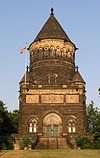
April 11, 1973 12316 Euclid Ave. in Lake View Cemetery
41°30′36″N 81°35′29″W / 41.51°N 81.591389°WCleveland Heights Extends into Cleveland[7] 55 Gates Mills Historic District October 9, 1991 Roughly along Berkshire, Chagrin River, Epping, Old Mill, and Sherman Rds.
41°31′38″N 81°24′32″W / 41.527222°N 81.408889°WGates Mills 56 Gates Mills Methodist Episcopal Church July 18, 1975 Old Mill Rd. off U.S. Route 322
41°31′04″N 81°24′17″W / 41.517778°N 81.404722°WGates Mills 57 Holsey Gates House 
June 30, 1975 762 Broadway
41°23′23″N 81°32′02″W / 41.389722°N 81.533889°WBedford 58 Edmund Gleason House 
December 18, 1978 7243 Canal Rd.
41°22′02″N 81°36′38″W / 41.367222°N 81.610556°WValley View 59 Grand Pacific Hotel October 10, 1975 8112 Columbia Rd.
41°22′27″N 81°54′08″W / 41.374167°N 81.902222°WOlmsted Falls 60 Gwinn Estate October 1, 1974 12407 Lake Shore Boulevard
41°33′36″N 81°35′58″W / 41.56°N 81.599444°WBratenahl 61 Harvey Hackenberg House July 7, 1983 1568 Grace Ave.
41°28′46″N 81°46′48″W / 41.479444°N 81.78°WLakewood 62 The Hangar January 9, 1986 24400 Cedar Rd.
41°30′01″N 81°30′23″W / 41.500278°N 81.506389°WBeachwood 63 Howard M. Hanna, Jr., House July 24, 1974 11505 Lake Shore Boulevard
41°33′21″N 81°36′34″W / 41.555833°N 81.609444°WBratenahl 64 Heights Rockfeller Building May 15, 1986 3091 Mayfield Rd.
41°30′58″N 81°34′08″W / 41.516111°N 81.568889°WCleveland Heights 65 Albert W. Henn Mansion April 28, 2000 23131 Lake Shore Boulevard
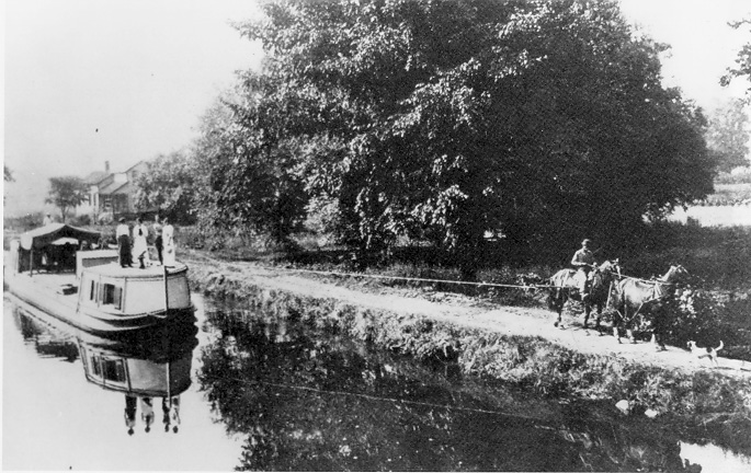
41°36′56″N 81°31′18″W / 41.615556°N 81.521667°WEuclid 66 Phillip Henninger House August 28, 2003 5757 Broadview Rd.
41°24′22″N 81°41′27″W / 41.406111°N 81.690833°WParma 67 Robert W. Henry House 
December 8, 1978 6607 Pearl Rd.
41°22′58″N 81°46′43″W / 41.382778°N 81.778611°WParma Heights 68 John Honam House 
April 13, 1977 14710 Lake Ave.
41°29′36″N 81°47′55″W / 41.493333°N 81.798611°WLakewood 69 John Huntington Pumping Tower February 28, 1979 28600 Lake Rd.
41°29′26″N 81°56′02″W / 41.490556°N 81.933889°WBay Village 70 Independence Presbyterian Church April 13, 1977 U.S. Route 21
41°22′55″N 81°38′30″W / 41.381944°N 81.641667°WIndependence 71 Inglewood Historic District April 15, 2009 Inglewood Dr., Oakridge Dr., Cleveland Heights Boulevard, Yellowstone and Glenwood Rds., and Quilliams
41°31′24″N 81°32′50″W / 41.523219°N 81.547089°WCleveland Heights 72 Jaite Mill Historic District 
May 21, 1979 Southeast of Brecksville at Riverview and Vaughan Rds.
41°17′10″N 81°34′06″W / 41.286111°N 81.568333°WBrecksville Extends into Sagamore Hills Township in Summit County 73 Gideon Keyt House June 1, 1982 Chagrin River and Deerfield Rds.
41°30′51″N 81°24′01″W / 41.514167°N 81.400278°WGates Mills 74 William Knapp House 
March 19, 1979 7101 Canal Rd.
41°22′20″N 81°36′42″W / 41.372222°N 81.611667°WValley View 75 Dr. William A. Knowlton House December 4, 1978 8937 Highland Dr.
41°19′11″N 81°37′48″W / 41.319722°N 81.63°WBrecksville 76 Joseph Kuenzer, II, House August 13, 1974 2345 Rockside Rd.
41°24′13″N 81°40′19″W / 41.403611°N 81.671944°WSeven Hills 77 E.J. Kulas Estate Historic District March 23, 1988 W. Hill Dr.
41°32′01″N 81°25′04″W / 41.533611°N 81.417778°WGates Mills 78 Samuel Lay House June 20, 1979 7622 Columbia Rd.
41°22′48″N 81°54′13″W / 41.38°N 81.903611°WOlmsted Falls 79 Lilly House April 12, 2006 27946 Center Ridge Rd.
41°26′42″N 81°55′55″W / 41.445°N 81.931944°WWestlake 80 Lock No. 37 and Spillway 
December 11, 1979 Fitzwater Rd.
41°21′24″N 81°35′50″W / 41.356667°N 81.597222°WValley View 81 Lock No. 38 and Spillway 
December 11, 1979 Hillside Rd.
41°22′21″N 81°36′46″W / 41.372597°N 81.612792°WValley View 82 Lock No. 39 and Spillway 
December 11, 1979 Canal Rd.
41°23′25″N 81°37′30″W / 41.390278°N 81.625°WValley View 83 Lock Tender's House and Inn December 11, 1979 7104 Canal Rd.
41°22′21″N 81°36′47″W / 41.3725°N 81.613056°WValley View 84 Look About Lodge April 12, 2006 37374 Miles Rd.
41°25′31″N 81°25′36″W / 41.42535°N 81.426719°WBentleyville 85 Lyceum Village Square And German Wallace College 
October 29, 1975 Seminary St.
41°22′06″N 81°51′06″W / 41.368333°N 81.851667°WBerea 86 George March House 
April 20, 1978 126 E. Washington St.
41°25′47″N 81°23′14″W / 41.429722°N 81.387222°WChagrin Falls 87 Duncan McFarland House November 21, 2001 35069 Cannon Rd.
41°24′33″N 81°25′24″W / 41.409167°N 81.423333°WBentleyville 88 Nela Park 
May 29, 1975 Entrance at 1901 Noble Rd.
41°32′28″N 81°33′32″W / 41.541111°N 81.558889°WEast Cleveland 89 James Nicholson House 
August 24, 1979 13335 Detroit Ave.
41°29′04″N 81°46′59″W / 41.484444°N 81.783056°WLakewood 90 North Olmsted Town Hall November 25, 1980 5186 Dover Center Rd.
41°24′51″N 81°55′27″W / 41.414167°N 81.924167°WNorth Olmsted 91 North Union Shaker Site August 13, 1974 Along Shaker Run below Upper Shaker Lake
41°29′0″N 81°33′50″W / 41.483333°N 81.56389°W[8]Shaker Heights 92 Julia Carter Northrop House October 14, 1975 7872 Columbia Rd.
41°22′35″N 81°54′10″W / 41.376389°N 81.902778°WOlmsted Falls 93 Notre Dame College of Ohio December 8, 1983 4545 College Rd.
41°30′28″N 81°30′56″W / 41.507778°N 81.515556°WSouth Euclid 94 Ohio and Erie Canal 
November 13, 1966 State Route 631
41°22′14″N 81°36′59″W / 41.370556°N 81.616389°WValley View 95 Old Center School April 3, 1973 784 S.O.M. Center Rd.
41°32′24″N 81°26′21″W / 41.54°N 81.439167°WMayfield 96 Old District 10 Schoolhouse 
October 15, 1973 Corner of Sheldon and Fry Rds.
41°23′18″N 81°48′54″W / 41.388333°N 81.815°WMiddleburg Heights 97 Old Euclid District 4 Schoolhouse April 16, 1980 Richmond Rd.
41°31′05″N 81°29′53″W / 41.518056°N 81.498056°WLyndhurst 98 Olmsted Falls Depot August 10, 2000 25802 Garfield Rd.
41°22′29″N 81°54′21″W / 41.374722°N 81.905833°WOlmsted Falls 99 Olmsted Falls Historic District July 14, 2000 Roughly bounded by Bagley Rd., Brookside Dr., the Rocky River, and Nobottom Rd.
41°22′37″N 81°54′00″W / 41.376944°N 81.9°WOlmsted Falls and Olmsted Township 100 Overlook Road Carriage House District May 6, 1974 1-5 Herrick Mews
41°30′12″N 81°35′50″W / 41.503333°N 81.597222°WCleveland Heights 101 Packard-Doubler House 
March 9, 1979 7634 Riverview Rd.
41°21′18″N 81°36′12″W / 41.355°N 81.603333°WIndependence 102 Jay M. Pickands House August 24, 1979 9619 Lake Shore Boulevard
41°32′44″N 81°37′24″W / 41.545556°N 81.623333°WBratenahl 103 Alanson Pomeroy House 
June 20, 1975 Pearl Rd. at Westwood Dr.
41°18′54″N 81°50′09″W / 41.315°N 81.835833°WStrongsville 104 Charles B. Rich House February 22, 1979 9367 Brecksville Rd.
41°18′25″N 81°37′36″W / 41.306944°N 81.626667°WBrecksville 105 Rose Hill and Community House May 13, 1994 Junction of Cahoon and Lake Rds.
41°29′16″N 81°55′36″W / 41.487778°N 81.926667°WBay Village 106 St. Joseph Convent and Academy Complex April 12, 2006 12215 Granger Rd.
41°25′13″N 81°35′52″W / 41.420278°N 81.597778°WGarfield Heights 107 St. Paul's Episcopal Church of East Cleveland October 18, 1984 15837 Euclid Ave.
41°32′31″N 81°34′14″W / 41.541944°N 81.570556°WEast Cleveland 108 Shaker Village Historic District 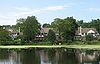
May 31, 1984 Roughly bounded by Fairmount and Lomond Boulevards and Green, Warrensville Center, Becket, and Coventry Rds.; also roughly bounded by Lomond Boulevard, Lytel Rd., Scottsdale Boulevard, and Lindholm Rd.
41°28′33″N 81°33′11″W / 41.475833°N 81.553056°WCleveland Heights and Shaker Heights Extends into Cleveland 109 Shore High School February 10, 2000 291 E. 222nd St.
41°36′25″N 81°31′35″W / 41.606944°N 81.526389°WEuclid 110 Russ and Holland Snow Houses September 28, 1982 12911 and 13114 Snowville Rd.
41°16′59″N 81°35′39″W / 41.283056°N 81.594167°WBrecksville 111 South Park Site June 22, 1976 On a promontory above the western bank of the Cuyahoga River, 7 miles from Lake Erie
41°22′42.5″N 81°37′20″W / 41.378472°N 81.62222°W[9]Independence 112 Station Road Bridge 
March 7, 1979 East of Brecksville at the Cuyahoga River
41°19′10″N 81°35′16″W / 41.319444°N 81.587778°WBrecksville Extends into Summit County 113 Lyman Stearns Farm 
October 1, 1981 6975 Ridge Rd.
41°22′30″N 81°43′43″W / 41.375°N 81.728611°WParma 114 Stebbens Farm April 17, 1996 8255 Riverview Rd.
41°20′19″N 81°35′40″W / 41.338611°N 81.594444°WBrecksville 115 Valerius C. Stone House December 22, 1978 21706 Lunn Rd.
41°17′52″N 81°51′56″W / 41.297778°N 81.865556°WStrongsville 116 Joseph Stoneman House May 29, 1975 18 E. Orange St.
41°25′59″N 81°23′32″W / 41.433056°N 81.392222°WChagrin Falls 117 John Stoughton Strong House 
November 24, 1980 18910 Westwood St.
41°18′55″N 81°50′06″W / 41.315278°N 81.835°WStrongsville 118 Strongsville Town Hall 
March 6, 2008 18825 Royalton Rd.
41°18′51″N 81°50′02″W / 41.314167°N 81.833889°WStrongsville 119 Taylor Mansion-Lakehurst July 10, 1986 193 Bratenahl Rd.
41°33′03″N 81°36′51″W / 41.550833°N 81.614167°WBratenahl 120 William E. Telling House October 16, 1974 4645 Mayfield Rd.
41°31′12″N 81°30′46″W / 41.52°N 81.512778°WSouth Euclid 121 Temple on the Heights March 29, 1984 3130 Mayfield Rd.
41°30′57″N 81°34′20″W / 41.515833°N 81.572222°WCleveland Heights 122 Terra Vista Archeological District May 23, 1978 On the edge of a bluff above the Cuyahoga River, north of its confluence with Tinkers Creek
41°22′6″N 81°36′37″W / 41.36833°N 81.61028°W[10]Valley View 123 W.A. Thorp House December 4, 1978 6183-6185 Mayfield Rd.
41°31′13″N 81°27′23″W / 41.520278°N 81.456389°WMayfield Heights 124 Tinkers Creek Aqueduct 
December 11, 1979 Tinkers Creek
41°21′53″N 81°36′33″W / 41.364722°N 81.609167°WValley View 125 Tremaine-Gallagher Residence 
October 30, 1973 3001 Fairmount Boulevard
41°29′18″N 81°34′18″W / 41.488333°N 81.571667°WCleveland Heights 126 Abraham Ulyatt House 
February 27, 1979 6579 Canal Rd.
41°23′10″N 81°37′11″W / 41.386111°N 81.619722°WValley View 127 Valley Railway Historic District May 17, 1985 Cuyahoga Valley between Rockside Rd. at the Cuyahoga Valley National Park and Howard St. at Little Cuyahoga Valley
41°13′38″N 81°34′13″W / 41.227222°N 81.570278°WBrecksville and Independence Extends into Summit County 128 Vaughn Site (33CU65) November 12, 1987 Near Cuyahoga Valley National Park headquarters
41°17′17.4″N 81°34′22.5″W / 41.288167°N 81.572917°W[11]Brecksville 129 Richard Vaughn Farm 
March 12, 1993 9570 Riverview Rd.
41°18′03″N 81°34′58″W / 41.300833°N 81.582778°WBrecksville 130 Moses Warren House 
October 22, 1974 3535 Ingleside Rd.
41°27′48″N 81°33′19″W / 41.463333°N 81.555278°WShaker Heights 131 Westlake Hotel October 20, 1983 19000 Lake Rd.
41°29′02″N 81°49′54″W / 41.483889°N 81.831667°WRocky River 132 John Wheeler House 
December 1, 1978 445 S. Rocky River Dr.
41°21′28″N 81°50′51″W / 41.357778°N 81.8475°WBerea 133 George W. Whitney House 
October 22, 1974 330 S. Rocky River Dr.
41°21′29″N 81°51′08″W / 41.358056°N 81.852222°WBerea 134 William Tricker Inc. Historic District March 2, 2001 7125 Tanglewood Rd.
41°23′20″N 81°38′23″W / 41.388889°N 81.639722°WIndependence 135 Wilson Feed Mill 
December 17, 1979 7604 Canal Rd.
41°21′22″N 81°35′48″W / 41.356111°N 81.596667°WValley View 136 Wilson's Mills Settlement District May 29, 1980 Chagrin River Rd.
41°33′01″N 81°24′56″W / 41.550208°N 81.41564°WGates Mills See also
References
- ^ The latitude and longitude information provided in this table was derived originally from the National Register Information System, which has been found to be fairly accurate for about 99% of listings. For about 1% of NRIS original coordinates, experience has shown that one or both coordinates are typos or otherwise extremely far off; some corrections may have been made. A more subtle problem causes many locations to be off by up to 150 yards, depending on location in the country: most NRIS coordinates were derived from tracing out latitude and longitudes off of USGS topographical quadrant maps created under North American Datum of 1927, which differs from the current, highly accurate GPS system used by Google maps. Chicago is about right, but NRIS longitudes in Washington are higher by about 4.5 seconds, and are lower by about 2.0 seconds in Maine. Latitudes differ by about 1.0 second in Florida. Some locations in this table may have been corrected to current GPS standards.
- ^ "National Register of Historic Places: Weekly List Actions". National Park Service, United States Department of the Interior. Retrieved on November 10, 2011.
- ^ Numbers represent an ordering by significant words. Various colorings, defined here, differentiate National Historic Landmark sites and National Register of Historic Places Districts from other NRHP buildings, structures, sites or objects.
- ^ "National Register Information System". National Register of Historic Places. National Park Service. . http://nrhp.focus.nps.gov/natreg/docs/All_Data.html.
- ^ Location derived from this Cleveland Clinic webpage; the NRIS lists the building as "Address Restricted"
- ^ Zoning Map, Cleveland Heights Department of Planning and Development, November 2005. Accessed 2009-09-05.
- ^ Plan of Lake View Cemetery, Lake View Cemetery. Accessed 2009-09-08.
- ^ Location derived from MacLean, J. P., Shakers of Ohio: Fugitive Papers Concerning the Shakers of Ohio, With Unpublished Manuscripts. Columbus: F.J. Heer, 1907, 120. The NRIS lists the site as "Address Restricted"
- ^ Location derived from Brose, David S. The South Park Village Site and the Late Prehistoric Whittlesey Tradition of Northeastern Ohio. "Monographs in World Archaeology" 20. Madison: Prehistory, 1994, 18-19. The NRIS lists the site as "Address Restricted"
- ^ Location derived from this National Park Service webpage; the NRIS lists the site as "Address Restricted"
- ^ Location derived from this National Park Service webpage; the NRIS lists the site as "Address Restricted"
Municipalities and communities of Cuyahoga County, Ohio County seat: Cleveland Cities Bay Village | Beachwood | Bedford | Bedford Heights | Berea | Brecksville | Broadview Heights | Brook Park | Brooklyn | Cleveland | Cleveland Heights | East Cleveland | Euclid | Fairview Park | Garfield Heights | Highland Heights | Independence | Lakewood | Lyndhurst | Maple Heights | Mayfield Heights | Middleburg Heights | North Olmsted | North Royalton | Olmsted Falls | Parma | Parma Heights | Pepper Pike | Richmond Heights | Rocky River | Seven Hills | Shaker Heights | Solon | South Euclid | Strongsville | University Heights | Warrensville Heights | Westlake

Villages Bentleyville | Bratenahl | Brooklyn Heights | Chagrin Falls | Cuyahoga Heights | Gates Mills | Glenwillow | Highland Hills | Hunting Valley‡ | Linndale | Mayfield | Moreland Hills | Newburgh Heights | North Randall | Oakwood | Orange | Valley View | Walton Hills | Woodmere
Townships Footnotes ‡This populated place also has portions in an adjacent county or counties
Categories:- National Register of Historic Places in Ohio by county
- Cuyahoga County, Ohio
-


Wikimedia Foundation. 2010.