- National Register of Historic Places listings in Des Moines County, Iowa
-
 Location of Des Moines County in Iowa
This is a list of the National Register of Historic Places listings in Des Moines County, Iowa.
This is intended to be a complete list of the properties and districts on the National Register of Historic Places in Des Moines County, Iowa, United States. Latitude and longitude coordinates are provided for many National Register properties and districts; these locations may be seen together in a Google map.[1]
There are 27 properties and districts listed on the National Register in the county.
-
- This National Park Service list is complete through NPS recent listings posted November 10, 2011.[2]
Current listings
[3] Landmark name [4] Image Date listed Location City or town Summary 1 Baptist Church April 18, 1977 West of Sperry off U.S. Route 61
40°57′30″N 91°11′56″W / 40.958333°N 91.198889°WSperry 2 Burlington and Missouri River Railroad Passenger Station October 22, 1976 237 S. 4th St.
40°48′22″N 91°06′19″W / 40.806111°N 91.105278°WBurlington 3 Burlington Public Library March 27, 1975 501 N. 4th St.
40°48′44″N 91°06′17″W / 40.812222°N 91.104722°WBurlington 4 Burlington, Cedar Rapids & Northern Freight House January 27, 1983 Front and High Sts.
40°48′50″N 91°05′56″W / 40.813889°N 91.098889°WBurlington 5 Cascade Bridge 
June 25, 1998 S. Main St. over the Cascade Ravine
40°46′52″N 91°05′54″W / 40.781111°N 91.098333°WBurlington 6 Chicago, Burlington, and Quincy Station February 4, 2002 300 S Main St.
40°48′20″N 91°06′06″W / 40.805556°N 91.101667°WBurlington 7 Church of St. John the Baptist February 26, 1982 712 Division St.
40°48′28″N 91°06′31″W / 40.807778°N 91.108611°WBurlington 8 Crapo Park and Arboretum Historic District June 3, 1976 Bounded by Parkway Dr., Koestner, Madison Rd., and the Mississippi River
40°46′33″N 91°06′07″W / 40.775833°N 91.101944°WBurlington 9 Mary Darwin House January 24, 1980 537 Summer St.
40°48′06″N 91°06′51″W / 40.801667°N 91.114167°WBurlington 10 Des Moines County Court House August 28, 2003 513 N. Main St.
40°48′42″N 91°05′59″W / 40.811667°N 91.099722°WBurlington 11 Augustus Caesar Dodge House January 25, 1980 829 N. 5th St.
40°48′57″N 91°06′11″W / 40.815833°N 91.103056°WBurlington 12 First Congregational Church November 21, 1976 313 N. 4th St.
40°48′38″N 91°06′15″W / 40.810556°N 91.104167°WBurlington 13 Flint River Bridge June 25, 1998 155th St. over the Flint River
40°54′19″N 91°13′22″W / 40.905278°N 91.222778°WBurlington 14 James M. Forney House September 22, 1986 401 Cedar
40°48′02″N 91°06′13″W / 40.800556°N 91.103611°WBurlington 15 German Methodist Episcopal Church September 22, 1977 7th and Washington Sts.
40°48′42″N 91°06′24″W / 40.811667°N 91.106667°WBurlington 16 Hawkeye Creek Bridge June 25, 1998 Hawkeye Rd. over Hawkeye Creek
41°02′33″N 91°03′26″W / 41.0425°N 91.057222°WMediapolis 17 Hedge Block October 7, 1982 401-407 Jefferson St.
40°48′39″N 91°06′11″W / 40.810833°N 91.103056°WBurlington 18 Heritage Hill Historic District December 21, 1982 Roughly bounded by Central Ave. and High, 3rd, and Jefferson Sts.
40°48′46″N 91°06′22″W / 40.812778°N 91.106111°WBurlington 19 Hotel Burlington December 31, 1987 206 N. 3rd St.
40°48′33″N 91°06′12″W / 40.809167°N 91.103333°WBurlington 20 Jagger-Churchill House March 5, 1982 201 Spring St.
40°49′00″N 91°06′03″W / 40.816667°N 91.100833°WBurlington 21 Dennis Melcher Melcher Pottery and House August 28, 2003 22981 and 22982 Agency Rd.
40°49′05″N 91°22′18″W / 40.818056°N 91.371667°WDanville 22 Schramm Building March 12, 1999 212 Jefferson St.
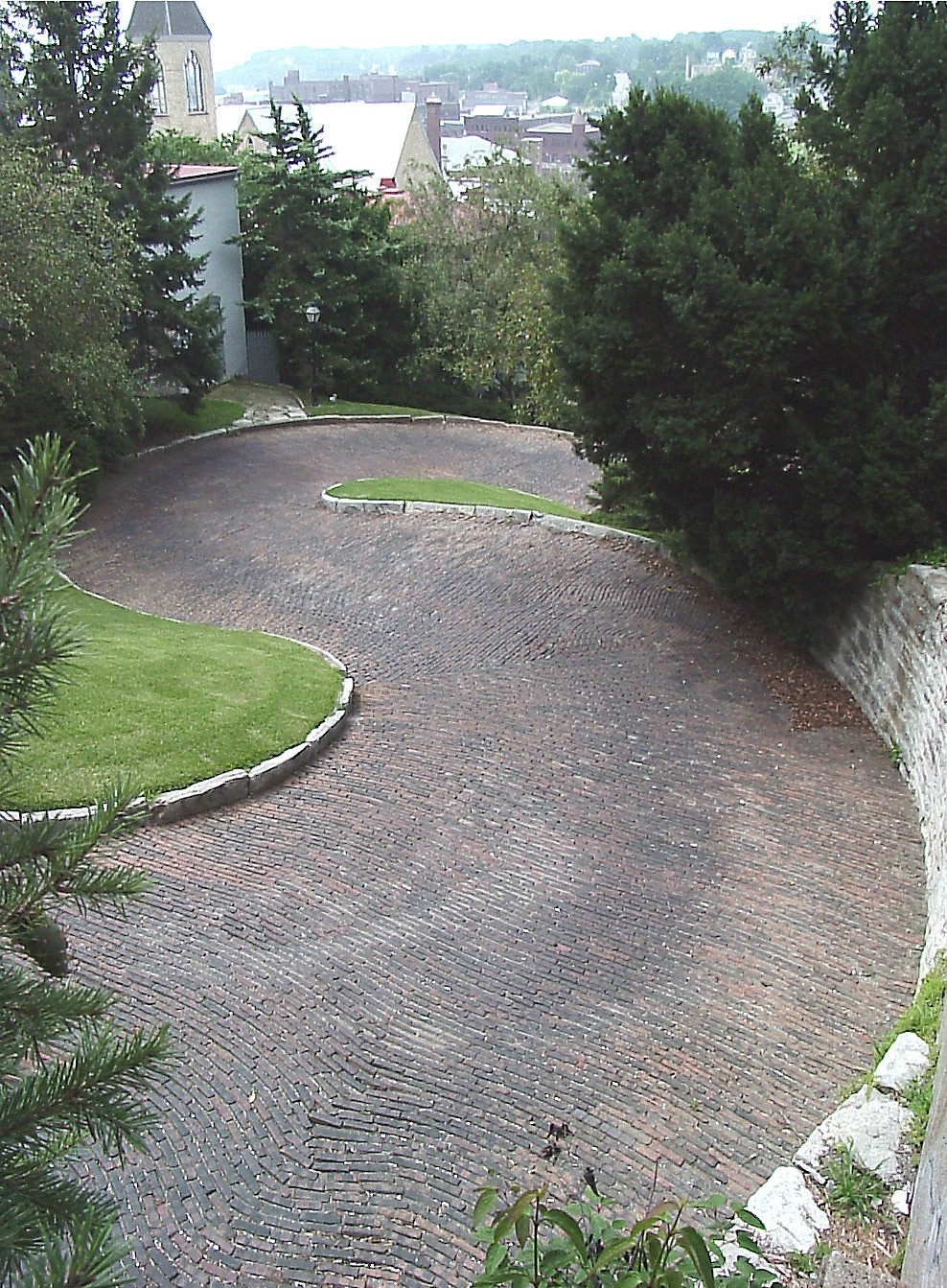
40°48′37″N 91°06′04″W / 40.810278°N 91.101111°WBurlington 23 Snake Alley 
September 6, 1974 N. 6th St. between Washington and Columbia Sts.
40°48′42″N 91°06′20″W / 40.811667°N 91.105556°WBurlington 24 Snake Alley Historic District May 21, 1975 Roughly bounded by Columbia and Washington Sts., Cobblestone Alley, and Service Dr.
40°48′43″N 91°06′22″W / 40.811944°N 91.106111°WBurlington 25 Starker-Leopold Historic District February 2, 1983 101 and 111 Clay and 110 Grand Sts.
40°47′43″N 91°05′47″W / 40.795278°N 91.096389°WBurlington 26 The Capitol Theater November 22, 1996 211 N. 3rd St.
40°48′34″N 91°06′10″W / 40.809444°N 91.102778°WBurlington 27 West Jefferson Street Historic District April 9, 1991 Roughly the 400 to 800 blocks of W. Jefferson St.
40°48′37″N 91°06′23″W / 40.810278°N 91.106389°WBurlington Formerly listed
[3] Landmark name Image Date listed Location City or town Summary 1 Union Hotel May 12, 2009[5] 301-311 S. Main St.
40°48′21″N 91°6′9″W / 40.80583°N 91.1025°WBurlington Added on April 4, 1993.[4] See also
References
- ^ The latitude and longitude information provided in this table was derived originally from the National Register Information System, which has been found to be fairly accurate for about 99% of listings. For about 1% of NRIS original coordinates, experience has shown that one or both coordinates are typos or otherwise extremely far off; some corrections may have been made. A more subtle problem causes many locations to be off by up to 150 yards, depending on location in the country: most NRIS coordinates were derived from tracing out latitude and longitudes off of USGS topographical quadrant maps created under North American Datum of 1927, which differs from the current, highly accurate GPS system used by Google maps. Chicago is about right, but NRIS longitudes in Washington are higher by about 4.5 seconds, and are lower by about 2.0 seconds in Maine. Latitudes differ by about 1.0 second in Florida. Some locations in this table may have been corrected to current GPS standards.
- ^ "National Register of Historic Places: Weekly List Actions". National Park Service, United States Department of the Interior. Retrieved on November 10, 2011.
- ^ a b Numbers represent an ordering by significant words. Various colorings, defined here, differentiate National Historic Landmark sites and National Register of Historic Places Districts from other NRHP buildings, structures, sites or objects.
- ^ a b "National Register Information System". National Register of Historic Places. National Park Service. . http://nrhp.focus.nps.gov/natreg/docs/All_Data.html.
- ^ "Weekly List". National Park Service. May 22, 2009. http://www.nps.gov/history/nr/listings/20090522.HTM. Retrieved May 24, 2009.
U.S. National Register of Historic Places Topics Lists by states Alabama • Alaska • Arizona • Arkansas • California • Colorado • Connecticut • Delaware • Florida • Georgia • Hawaii • Idaho • Illinois • Indiana • Iowa • Kansas • Kentucky • Louisiana • Maine • Maryland • Massachusetts • Michigan • Minnesota • Mississippi • Missouri • Montana • Nebraska • Nevada • New Hampshire • New Jersey • New Mexico • New York • North Carolina • North Dakota • Ohio • Oklahoma • Oregon • Pennsylvania • Rhode Island • South Carolina • South Dakota • Tennessee • Texas • Utah • Vermont • Virginia • Washington • West Virginia • Wisconsin • WyomingLists by territories Lists by associated states Other Municipalities and communities of Des Moines County, Iowa Cities 
Townships Benton | Concordia | Danville | Flint River | Franklin | Huron | Jackson | Pleasant Grove | Tama | Union | Washington | Yellow Springs
Unincorporated
communitiesCategories:- National Register of Historic Places in Iowa by county
- Des Moines County, Iowa
- Buildings and structures in Des Moines County, Iowa
-


Wikimedia Foundation. 2010.