- National Register of Historic Places listings in Douglas County, Kansas
-
 Location of Douglas County in Kansas
This is a list of the National Register of Historic Places listings in Douglas County, Kansas.
This is intended to be a complete list of the properties and districts on the National Register of Historic Places in Douglas County, Kansas, United States. The locations of National Register properties and districts for which the latitude and longitude coordinates are included below, may be seen in a Google map.[1]
There are 68 properties and districts listed on the National Register in the county, including 2 National Historic Landmarks.
-
- This National Park Service list is complete through NPS recent listings posted November 10, 2011.[2]
Current listings
[3] Landmark name [4] Image Date listed Location City or town Summary 1 Ralph and Cloyd Achning House 
September 15, 1987 846 Missouri St.
38°58′04″N 95°14′50″W / 38.967778°N 95.247222°WLawrence 2 Bailey Hall October 22, 2001 Junction of Jayhawk Dr. and Sunflower Rd.
38°57′28″N 95°14′46″W / 38.957778°N 95.246111°WLawrence 3 Barnes Apple Barn 
November 1, 2006 714 E. 1728 Rd.
38°50′34″N 95°10′53″W / 38.842778°N 95.181389°WBaldwin City 4 George and Annie Bell House 
August 11, 1983 1008 Ohio St.
38°57′55″N 95°15′06″W / 38.965278°N 95.251667°WLawrence 5 Benedict House 
January 22, 1992 923 Tennessee St.
38°57′59″N 95°14′23″W / 38.966389°N 95.239722°WLawrence 6 Black Jack Battlefield 
April 28, 2004 U.S. Route 56 and County Road 2000, 3.0 miles east of Baldwin City
38°45′56″N 95°07′45″W / 38.765556°N 95.129167°WBaldwin City 7 Col. James Blood House 
February 23, 1972 1015 Tennessee St.
38°57′54″N 95°14′22″W / 38.965°N 95.239444°WLawrence 8 Breezedale Historic District 
January 31, 2008 2301-2401 Massachusetts St.
38°56′30″N 95°14′09″W / 38.941667°N 95.235833°WLawrence 9 Case Library 
June 5, 1986 Baker University, Eighth and Grove
38°46′39″N 95°11′20″W / 38.7775°N 95.188889°WBaldwin City 10 Chicken Creek Bridge 
March 5, 1990 Over Chicken Creek, southeast of Lone Star
38°51′11″N 95°20′35″W / 38.853056°N 95.343056°WLone Star 11 Clinton School District 25 
May 1, 1998 1180 N. 604 East Rd.
38°55′16″N 95°23′24″W / 38.921111°N 95.39°WLawrence Now the Clinton city hall 12 Coal Creek Library 
December 10, 2003 698 E. 1719 Rd.
38°50′25″N 95°10′15″W / 38.840278°N 95.170833°WVinland 13 Constitution Hall 
May 14, 1971 Elmore St. between Woodson and 3rd Sts.
39°02′44″N 95°23′40″W / 39.045556°N 95.394444°WLecompton 14 Double Hyperbolic Paraboloid House 
June 27, 2007 934 W. 21st. St.
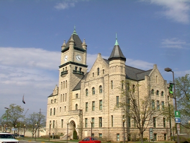
38°56′47″N 95°14′48″W / 38.946389°N 95.246667°WLawrence 15 Douglas County Courthouse 
April 14, 1975 Southeastern corner of Massachusetts and 11th Sts.
38°57′48″N 95°14′07″W / 38.963333°N 95.235278°WLawrence 16 Charles Duncan House 
June 5, 1986 933 Tennessee St.
38°58′01″N 95°14′59″W / 38.966944°N 95.249722°WLawrence 17 Dyche Hall, University of Kansas 
July 14, 1974 14th St. and Oread Ave., University of Kansas campus
38°57′31″N 95°14′38″W / 38.958611°N 95.243889°WLawrence 18 East Lawrence Industrial Historic District 
December 11, 2007 619 E. 8th St., 804-846 Pennsylvania St., and 716 E. 9th St. Lawrence 19 Eldridge House Hotel 
December 1, 1986 Seventh and Massachusetts Sts.
38°58′17″N 95°14′05″W / 38.971389°N 95.234722°WLawrence 20 English Lutheran Church 
July 28, 1995 1040 New Hampshire St.
38°57′34″N 95°13′41″W / 38.959444°N 95.228056°WLawrence 21 Fernand-Strong House July 2, 2008 1515 University Dr.
38°57′38″N 95°15′11″W / 38.960556°N 95.253056°WLawrence 22 Eugene F. Goodrich House 
October 21, 2001 1711 Massachusetts St.
38°57′10″N 95°14′11″W / 38.952778°N 95.236389°WLawrence 23 Green Hall, University of Kansas July 15, 1974 Jayhawk Dr.
38°57′29″N 95°14′40″W / 38.958056°N 95.244444°WLawrence 24 Michael D. Greenlee House 
February 20, 2004 947 Louisiana St.
38°58′01″N 95°14′36″W / 38.966944°N 95.243333°WLawrence 25 Hancock (12th Street) Historic District 
July 21, 2004 Roughly along W. 12th St., from Oread Ave. to Mississippi St.
38°57′42″N 95°14′39″W / 38.961667°N 95.244167°WLawrence 26 Haskell Institute 
October 15, 1966 Southern end of Barker Ave.[5]
38°56′19″N 95°14′00″W / 38.938611°N 95.233333°WLawrence 27 Edward House House 
April 18, 2007 1646 Massachusetts St.
38°57′13″N 95°14′08″W / 38.953611°N 95.235556°WLawrence 28 Lane University 
March 24, 1971 Eastern side of Lecompton
39°02′42″N 95°23′29″W / 39.045°N 95.391389°WLecompton Now the Territorial Capital Museum 29 Lawrence's Downtown Historic District 
July 15, 2004 Generally along Massachusetts St. between 6th Ave. and S. Park St.
38°57′59″N 95°14′10″W / 38.966389°N 95.236111°WLawrence 30 Ludington House 
May 14, 1971 1613 Tennessee St.
38°57′15″N 95°14′23″W / 38.954167°N 95.239722°WLawrence 31 George K. Mackie House July 8, 2009 1941 Massachusetts St.
38°56′58″N 95°14′09″W / 38.949333°N 95.235925°WLawrence 32 Witter S. McCurdy House 
October 21, 2001 909 W. 6th St.
40°45′18″N 95°18′20″W / 40.755°N 95.305556°WLawrence 33 Robert H. Miller House 
June 14, 1984 1111 E. 19th St.
38°56′59″N 95°13′16″W / 38.949722°N 95.221111°WLawrence 34 Dr. Frederic D. Morse House 
April 18, 1991 1041 Tennessee St.
38°57′52″N 95°14′20″W / 38.964444°N 95.238889°WLawrence 35 North Rhode Island Street Historic Residential District 
July 14, 2004 700-1144, 901-1047, 1201-1215 Rhode Island St.
38°57′41″N 95°14′00″W / 38.961389°N 95.233333°WLawrence 36 Old Castle Hall, Baker University 
February 24, 1971 513 5th St.
38°46′38″N 95°11′04″W / 38.777222°N 95.184444°WBaldwin City 37 Old Lawrence City Hall 
February 24, 1971 1047 Massachusetts St.
38°57′51″N 95°14′04″W / 38.964167°N 95.234444°WLawrence Built 1885-88 for Watkins National Bank; city hall, 1929-1970; Watkins Community Museum since 1975. 38 Old Lawrence City Library 
February 18, 1975 Northwestern corner of 9th and Vermont Sts.
38°58′04″N 95°14′15″W / 38.967778°N 95.2375°WLawrence 39 Old West Lawrence Historic District 
February 23, 1972 Bounded roughly by Tennessee, 8th, Indiana, and 6th Sts.
38°58′15″N 95°14′27″W / 38.970833°N 95.240833°WLawrence 40 Oread Historic District 
October 10, 2007 Roughly between W. 9th & 12th Sts., and the alleys behind Louisiana & Kentucky Sts. Lawrence 41 Parmenter Memorial Hall 
September 19, 1977 8th and Dearborn Sts.
38°46′42″N 95°11′15″W / 38.778333°N 95.1875°WBaldwin City 42 Charles Pilla House September 6, 1974 615 Elm St.
38°56′52″N 95°05′53″W / 38.947778°N 95.098056°WEudora 43 Pinckney I Historic District 
July 15, 2004 Roughly bounded by W. 5th St., Tennessee St., W. 6th St., and Louisiana St., with 501-533 Louisiana St. and 444-445 W. St.
38°58′27″N 95°14′30″W / 38.974167°N 95.241667°WLawrence 44 Pinckney II Historic District 
July 15, 2004 Roughly bounded by W. 3rd St., Louisiana St., W. 4th St. and Mississippi St.
38°58′39″N 95°14′40″W / 38.9775°N 95.244444°WLawrence 45 Plymouth Congregational Church 
September 2, 2009 925 Vermont Street
37°58′00″N 95°14′14″W / 37.966528°N 95.237361°WLawrence 46 Priestly House 
March 10, 1988 1505 Kentucky St.
38°57′26″N 95°14′18″W / 38.957222°N 95.238333°WLawrence 47 William A. Quayle House 
February 2, 1995 210 N. 6th St.
38°47′04″N 95°11′07″W / 38.784444°N 95.185278°WBaldwin City 48 Samuel A. Riggs House 
August 29, 1977 1500 Pennsylvania St.
38°57′24″N 95°13′43″W / 38.956667°N 95.228611°WLawrence 49 John N. Roberts House 
September 6, 1974 1307 Massachusetts St.
38°57′36″N 95°14′11″W / 38.96°N 95.236389°WLawrence Also known as the Castle Tea Room 50 St. Luke African Methodist Episcopal Church 
November 15, 2005 900 New York St.
38°58′03″N 95°13′50″W / 38.9675°N 95.230556°WLawrence 51 Santa Fe Depot 
January 3, 1983 1601 High St.
38°46′29″N 95°12′02″W / 38.774722°N 95.200556°WBaldwin City 52 Santa Fe Trail-Douglas County Trail Segments 
November 4, 2002 U.S. Route 56, 2.5 miles east of Baldwin City
38°46′01″N 95°07′46″W / 38.766944°N 95.129444°WBaldwin City 53 Snow House 
September 9, 1996 706 W. 12th St.
38°57′44″N 95°13′54″W / 38.962222°N 95.231667°WLawrence 54 South Rhode Island and New Hampshire Street Historic Residential District July 14, 2004 1120-1340 E. Rhode Island St; 1301-1345 W. Rhode Island St.; 1300-1346 E. New Hampshire St.; 1301-1347 W. New Hampshire St.
38°57′35″N 95°14′01″W / 38.959722°N 95.233611°WLawrence 55 Spooner Hall, University of Kansas 
July 15, 1974 14th St. and Oread Ave. on the University of Kansas campus
38°57′30″N 95°14′48″W / 38.958333°N 95.246667°WLawrence 56 Judge Nelson T. Stephens House February 19, 1982 340 N. Michigan St.
38°59′23″N 95°14′56″W / 38.989722°N 95.248889°WLawrence 57 Stoebener Barn January 9, 1989 Southwest of Worden
38°46′23″N 95°20′52″W / 38.773056°N 95.347778°WBaldwin City 58 Stony Point Evangelical Lutheran Church 
December 20, 2006 1575 N. 600 Rd.
38°49′30″N 95°12′38″W / 38.825°N 95.210556°WBaldwin City 59 Strong Hall September 18, 1998 213 Strong Hall, University of Kansas, at the junction of Jayhawk Dr. and Poplar Ln.
38°57′35″N 95°14′48″W / 38.959722°N 95.246667°WLawrence 60 Lucy Hobbs Taylor Building 
February 19, 1982 809 Vermont
38°58′05″N 95°14′17″W / 38.968056°N 95.238056°WLawrence 61 US Post Office-Lawrence 
October 31, 2002 645 New Hampshire
38°58′17″N 95°14′06″W / 38.971389°N 95.235°WLawrence Now offices of The World Company and the Lawrence Journal-World 62 United Presbyterian Center September 29, 2009 1204 Oread Ave.
38°57′38″N 95°14′34″W / 38.960503°N 95.242711°WLawrence 63 John Palmer Usher House 
March 7, 1975 1425 Tennessee St.
38°57′27″N 95°14′23″W / 38.9575°N 95.239722°WLawrence 64 Vermilya-Boener House 
January 24, 1992 Northwest of junction of U.S. Routes 24, 40, and 59
39°00′56″N 95°14′33″W / 39.015556°N 95.2425°WLawrence 65 Vinland Fair Association Fairgrounds Exhibit Building January 23, 2004 1736 N. 700 Rd.
38°50′34″N 95°09′59″W / 38.842778°N 95.166389°WVinland 66 Vinland Grange Hall 
February 10, 2000 Junction of Oak and Main Sts.
38°50′21″N 95°10′56″W / 38.839167°N 95.182222°WVinland 67 Vinland Presbyterian Church 
August 4, 2003 697 E. 1725 Rd.
38°50′25″N 95°10′53″W / 38.840278°N 95.181389°WVinland 68 S.T. Zimmerman House 
September 6, 1974 304 Indiana St.
38°58′44″N 95°13′52″W / 38.978889°N 95.231111°WLawrence See also
- List of National Historic Landmarks in Kansas
- National Register of Historic Places listings in Kansas
References
- ^ The latitude and longitude information provided in this table was derived originally from the National Register Information System, which has been found to be fairly accurate for about 99% of listings. For about 1% of NRIS original coordinates, experience has shown that one or both coordinates are typos or otherwise extremely far off; some corrections may have been made. A more subtle problem causes many locations to be off by up to 150 yards, depending on location in the country: most NRIS coordinates were derived from tracing out latitude and longitudes off of USGS topographical quadrant maps created under North American Datum of 1927, which differs from the current, highly accurate GPS system used by Google maps. Chicago is about right, but NRIS longitudes in Washington are higher by about 4.5 seconds, and are lower by about 2.0 seconds in Maine. Latitudes differ by about 1.0 second in Florida. Some locations in this table may have been corrected to current GPS standards.
- ^ "National Register of Historic Places: Weekly List Actions". National Park Service, United States Department of the Interior. Retrieved on November 10, 2011.
- ^ Numbers represent an ordering by significant words. Various colorings, defined here, differentiate National Historic Landmark sites and National Register of Historic Places Districts from other NRHP buildings, structures, sites or objects.
- ^ "National Register Information System". National Register of Historic Places. National Park Service. . http://nrhp.focus.nps.gov/natreg/docs/All_Data.html.
- ^ The NRIS lists the site as "address unknown" but provides coordinates; this address is derived from those coordinates
Municipalities and communities of Douglas County, Kansas County seat: Lawrence Cities Baldwin City | Eudora | Lawrence | Lecompton

Townships Unincorporated
communitiesBig Springs | Clearfield | Clinton | Globe | Grover | Hesper | Kanwaka | Lake View | Lone Star | Midland | Pleasant Grove | Sibleyville | Stull | Vinland | Worden
Ghost towns Categories:- Douglas County, Kansas
- National Register of Historic Places in Kansas by county
- Buildings and structures in Douglas County, Kansas
-


Wikimedia Foundation. 2010.