- National Register of Historic Places listings in Durham County, North Carolina
-

This list includes properties and districts listed on the National Register of Historic Places in Durham County, North Carolina. Click the "Map of all coordinates" link to the right to view a Google map of all properties and districts with latitude and longitude coordinates in the table below.[1]
-
- This National Park Service list is complete through NPS recent listings posted November 10, 2011.[2]
[3] Landmark name[4] Image Date listed Location City or Town Summary 1 American Tobacco Company Manufacturing Plant September 29, 2000 Roughly bounded by W. Pettigrew St., Blackwell St., Willard St. and Carr St.
35°59′43″N 78°54′17″W / 35.99528°N 78.90472°WDurham 2 Bassett House November 29, 1979 1017 W. Trinity Ave.
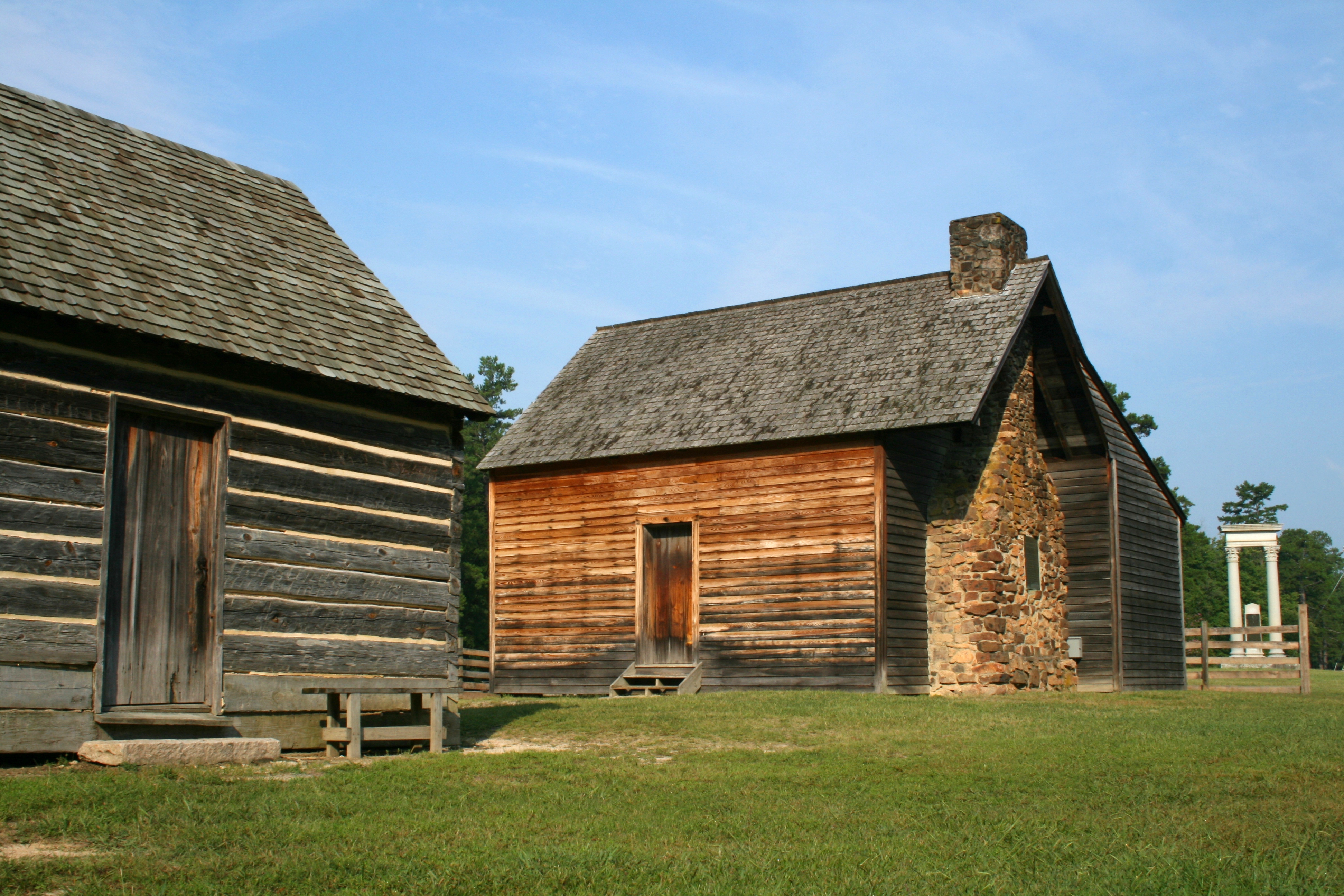
36°0′20″N 78°54′38″W / 36.00556°N 78.91056°WDurham 3 Bennett Place State Historic Site 
February 26, 1970 Jct. of SR 1313 and 1314
36°1′45″N 78°58′32″W / 36.02917°N 78.97556°WDurham Site of the largest surrender of Confederate troops during the Civil War, April 26, 1865[5] 4 Richard D. Blacknall House March 1, 1990 300 Alexander Ave.
36°0′13″N 78°55′38″W / 36.00361°N 78.92722°WDurham 5 Bright Leaf Historic District December 30, 1999 Roughly bounded by W. Peabody St., Duke St., Minerva Ave., N&W RR, Corporation St., Ligget St., Morris St. and W. Loop
36°0′6″N 78°54′21″W / 36.00167°N 78.90583°WDurham 6 Bull Durham Tobacco Factory 
September 10, 1974 201 W. Pettigrew St.
35°59′38″N 78°54′16″W / 35.99389°N 78.90444°WDurham Also known as W. T. Blackwell and Company Tobacco Factory 7 Bullington Warehouse August 30, 1982 500 N. Duke St.
36°0′10″N 78°54′22″W / 36.00278°N 78.90611°WDurham 8 Burch Avenue Historic District September 3, 2010 Roughly bounded by S. Buchanan Blvd., W. Chapel Hill St., Duke University Rd., Burch Ave., and Rome Ave.
35°59′53″N 78°55′3″W / 35.99806°N 78.9175°WDurham 9 John C. and Binford Carr House August 5, 2011 3400 Westover Rd.,
35°56′48″N 78°57′22″W / 35.94667°N 78.95611°WDurham 10 City Garage Yard and Fire Drill Tower May 3, 2000 501 Washington St.
36°0′38″N 78°54′37″W / 36.01056°N 78.91028°WDurham 11 Clark and Sorrell Garage August 16, 2000 323 Foster St.
36°0′3″N 78°54′47″W / 36.00083°N 78.91306°WDurham 12 Cleveland Street District September 20, 1985 Roughly Cleveland St. between Seminary & Gray Aves. & Mallard St.
35°59′59″N 78°53′42″W / 35.99972°N 78.895°WDurham 13 Cranford-Wannamaker House November 29, 1979 1019 W. Trinity Ave.
36°0′22″N 78°54′38″W / 36.00611°N 78.91056°WDurham 14 Crowell House November 29, 1979 504 Watts St.
36°0′22″N 78°54′41″W / 36.00611°N 78.91139°WDurham 15 Dillard-Gamble Houses January 19, 1979 1311 and 1307 N. Mangum St.
36°0′32″N 78°53′38″W / 36.00889°N 78.89389°WDurham 16 Downtown Durham Historic District November 1, 1977 Roughly bounded by Peabody, Morgan, Seminary, Cleveland, Parrish, and Queen Sts.
35°59′42″N 78°54′1″W / 35.995°N 78.90028°WDurham 17 Duke Homestead and Tobacco Factory 
November 13, 1966 0.5 miles N of Durham on Guess Rd., E of SR 1025
36°2′6″N 78°55′16″W / 36.035°N 78.92111°WDurham 18 Duke Memorial United Methodist Church 
August 11, 1985 504 W. Chapel Hill St.
35°59′51″N 78°54′34″W / 35.9975°N 78.90944°WDurham 19 Durham Cotton Mills Village Historic District August 9, 1985 Roughly bounded by Byrd and Middle Sts., E. Frontage Rd. and Reservoir St.
35°58′36″N 78°52′56″W / 35.97667°N 78.88222°WDurham 20 Durham Hosiery Mill 
November 14, 1978 Angier Ave.
35°59′19″N 78°53′34″W / 35.98861°N 78.89278°WDurham 21 Durham Hosiery Mills No. 2-Service Printing Company Building November 27, 1985 504 E. Pettigrew St.
35°59′23″N 78°53′52″W / 35.98972°N 78.89778°WDurham Burned 1985/Deteriorated[6] 22 East Durham Historic District December 23, 2004 Roughly bounded by Southern Rwy right-of-way, N. Guthrie Ave. Holloway St., Hyde Park Ave, S. Plum St. and Vale St.
35°59′39.04″N 78°52′31.36″W / 35.9941778°N 78.8753778°WDurham 23 Emmanuel AME Church August 9, 1985 710 Kent St.
35°59′40″N 78°55′8″W / 35.99444°N 78.91889°WDurham 24 Ephphatha Church August 9, 1985 220 W. Geer St.
36°0′20″N 78°53′53″W / 36.00556°N 78.89806°WDurham 25 Erwin Cotton Mills Company Mill No. 1 Headquarters Building November 20, 1984 W. Main and 9th Sts.
36°0′27″N 78°55′24″W / 36.0075°N 78.92333°WDurham 26 Fairntosh Plantation April 3, 1973 Near jct. of SR 1004 and 1632
36°5′56″N 78°49′42″W / 36.09889°N 78.82833°WDurham 27 Wiley and Elizabeth Forbus House April 28, 2005 3307 Devon Rd.
35°57′6.75″N 78°57′10.69″W / 35.951875°N 78.9529694°WDurham 28 Forest Hills Historic District December 28, 2005 Roughly bounded by Kent St., Bivins St., Wells St., American Tobacco Trail, Forestwood Dr. and Beverly Dr.
35°58′55″N 78°54′53″W / 35.98194°N 78.91472°WDurham 29 Golden Belt Historic District August 9, 1985 Roughly bounded by N & W RR, Taylor, Holman Sts., Morning Glory Ave., and Main St.; also 1000-1004 E. Main St.
35°59′26″N 78°53′20″W / 35.99056°N 78.88889°WDurham Second set of addresses represents a boundary increase of July 30, 1996 30 Greystone Manor 
June 1, 1982 618 Morhead Ave.
35°59′32″N 78°54′32″W / 35.99222°N 78.90889°WDurham 31 Hardscrabble January 20, 1972 N side of SR 1002, 1.2 miles W of jct. with SR 1003
36°8′1″N 78°57′36″W / 36.13361°N 78.96°WBahama 32 John Sprunt Hill House January 30, 1978 900 S. Duke St.
35°59′18″N 78°54′36″W / 35.98833°N 78.91°WDurham 33 Holloway Street District September 20, 1985 Roughly bounded by Holloway, Railroad, and Liberty Sts., Peachtree Pl., and Dillard St.; also roughly bounded by Holloway, Elizabeth, Primitive, and Queen Sts., and Mallard Ave.
35°59′43″N 78°53′30″W / 35.99528°N 78.89167°WDurham Second set of boundaries represents a boundary increase of April 30, 2009 34 Kinchen Holloway House August 29, 2008 4418 Guess Rd.
36°4′25.54″N 78°55′59.34″W / 36.0737611°N 78.93315°WDurham 35 Hope Valley Historic District December 11, 2009 Avon Rd., Chelsea Circle, Cornwall Rd., Devon Rd. Exeter Way, Littlewoods Ln., Norwich Way, Stratford Rd.
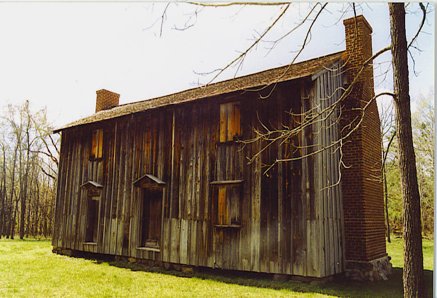
35°56′55.56″N 78°56′52.42″W / 35.9487667°N 78.9478944°WDurham 36 Horton Grove Complex 
March 17, 1978 N of Durham on SR 1626
36°7′35″N 78°50′22″W / 36.12639°N 78.83944°WDurham 37 Lakewood Park Historic District May 1, 2003 1601-1907 W. Lakewood Ave., 2001-2112 Chapel Hill Rd., 1406-1601 James St. and 1809-1819 Bivins St.
35°59′14″N 78°55′33″W / 35.98722°N 78.92583°WDurham 38 Leigh Farm September 5, 1975 E of Chapel Hill off NC 54
35°55′19″N 78°58′58″W / 35.92194°N 78.98278°WChapel Hill 39 Liberty Warehouse Nos. 1 and 2 August 6, 2008 611-613 Rigsbee Ave.
36°0′4.68″N 78°53′59.89″W / 36.0013°N 78.8999694°WDurham 40 Little Creek Site (31 DH 351) January 11, 1985 Address Restricted Chapel Hill 41 Bartlett Mangum House May 25, 1989 2701 Chapel Hill Rd.
35°58′37″N 78°56′10″W / 35.97694°N 78.93611°WDurham 42 Meadowmont July 11, 1985 Off NC 54
35°54′40″N 79°0′19″W / 35.91111°N 79.00528°WChapel Hill 43 Morehead Hill Historic District August 9, 1985 Roughly bounded by Jackson St., East-West Expressway, S. Duke St., Lakewood Ave., Shephard St., and Arnette Ave.; also portions of Arnette, Vickers, Yancey, Parker, and Wells Sts.
35°59′23″N 78°54′46″W / 35.98972°N 78.91278°WDurham Second set of boundaries represents a boundary increase of June 2, 2004 44 North Carolina Central University March 28, 1986 Bounded by Lawson St., Alston Ave., Nelson, and Fayette Sts.
35°58′22.74″N 78°53′46.64″W / 35.9729833°N 78.8962889°WDurham 45 North Carolina Mutual Life Insurance Company Building 
May 15, 1975 114-116 W. Parrish St.
35°59′43″N 78°54′2″W / 35.99528°N 78.90056°WDurham 46 North Durham County Prison Camp (Former) December 31, 1998 2410 Broad St.
36°1′57.32″N 78°54′38.99″W / 36.0325889°N 78.9108306°WDurham 47 North Durham-Duke Park District June 20, 1985 Roughly bounded by Glendale Ave., W. Knox St., Roxboro Rd., Trinity Ave., Magnum & Broadway Sts.
36°0′22″N 78°53′38″W / 36.00611°N 78.89389°WDurham 48 William Thomas O'Brien House August 9, 1985 820 Wilkerson Ave.
36°0′6″N 78°54′55″W / 36.00167°N 78.91528°WDurham 49 Pearl Mill Village Historic District August 9, 1985 900 Blk. of Washington and Orient Sts. between Trinity and Dacien Aves.
36°0′19″N 78°54′8″W / 36.00528°N 78.90222°WDurham 50 Pegram House November 29, 1979 1019 Minerva Ave.
36°0′20″N 78°54′38″W / 36.00556°N 78.91056°WDurham 51 George Poland House December 4, 2004 502 John Jones Rd.
36°8′43.09″N 78°53′40.9″W / 36.1453028°N 78.894694°WBahama 52 Powe House August 9, 1985 1503 W. Pettigrew St.
36°0′18″N 78°55′11″W / 36.005°N 78.91972°WDurham 53 Russell School August 5, 2009 2001 St. Mary's Rd. (S. side SR 1002 .1 miles W of jct with SR 1003)
36°7′24.03″N 78°56′44.87″W / 36.1233417°N 78.9457972°WDurham 54 Scarborough House August 9, 1985 1406 Fayetteville St.
35°58′41″N 78°54′2″W / 35.97806°N 78.90056°WDurham 55 Smith Warehouse September 16, 1985 100 N. Buchanan Blvd.
36°0′5″N 78°54′57″W / 36.00139°N 78.91583°WDurham 56 St. Joseph's African Methodist Episcopal Church 
August 11, 1976 Fayetteville St. and Durham Expwy.
35°59′11″N 78°53′53″W / 35.98639°N 78.89806°WDurham 57 Stagville 
May 25, 1973 Near junction of SR 1004 and 1632
36°6′3″N 78°50′19″W / 36.10083°N 78.83861°WDurham 58 Stokesdale Historic District December 28, 2010 Roughly bounded by Fayetteville St., Umstead St., Lawson St., Moline St., Concord St., and Dunstan St.
35°58′48″N 78°54′4″W / 35.98°N 78.90111°WDurham 59 Marcus Tilley House January 14, 2000 7616 Jock Rd.
36°9′20″N 78°50′26″W / 36.15556°N 78.84056°WBahama 60 Trinity Historic District March 26, 1986 Roughly bounded by Green, Duke, Morgan, and W. Main Sts., Markham Ave., and Clarendon St.; also roughly bounded by the original Trinity Historic District, N. Buchanan Boulevard, W. Club Boulevard, Woodland Dr., and N. Duke St.; also 209-215 N. Gregson St.
36°0′22″N 78°54′43″W / 36.00611°N 78.91194°WDurham Second and third sets of boundaries represent boundary increases of June 4, 2004 and January 9, 2008 respectively 61 Adolphus W. Umstead House September 14, 1989 NC 1607, 0.5 miles N of NC 1611
36°11′7″N 78°51′16″W / 36.18528°N 78.85444°WBahama 62 Venable Tobacco Company Prizery and Receiving Room August 21, 2003 302-04 East Pettigrew
35°59′35″N 78°53′58″W / 35.99306°N 78.89944°WDurham 63 Venable Tobacco Company Warehouse August 9, 1985 302-304 E. Pettigrew St.
35°59′31″N 78°54′0″W / 35.99194°N 78.9°WDurham 64 Watts and Yuille Warehouses April 5, 1984 905 W. Main St.
36°0′1″N 78°54′37″W / 36.00028°N 78.91028°WDurham 65 Watts Hospital 
April 2, 1980 Broad St. and Club Blvd.
36°1′9″N 78°55′15″W / 36.01917°N 78.92083°WDurham 66 Watts-Hillandale Historic District April 25, 2001 Roughly bounded by Durham Waterworks, Wilson St., Sprunt Ave., Broad St., Englewood Ave., and Hillsborough Rd.
36°1′14″N 78°55′45″W / 36.02056°N 78.92917°WDurham 67 West Durham Historic District March 26, 1986 Roughly bounded by Knox, Ninth, W. Main Sts., and Rutherford St. and Carolina Ave.
36°0′41″N 78°55′28″W / 36.01139°N 78.92444°WDurham 68 West Point on the Eno 
August 9, 1985 Roxboro Rd.
36°4′11″N 78°54′31″W / 36.06972°N 78.90861°WDurham See also
- National Register of Historic Places listings in North Carolina
- List of National Historic Landmarks in North Carolina
References
- ^ The latitude and longitude information provided in this table was derived originally from the National Register Information System, which has been found to be fairly accurate for about 99% of listings. For about 1% of NRIS original coordinates, experience has shown that one or both coordinates are typos or otherwise extremely far off; some corrections may have been made. A more subtle problem causes many locations to be off by up to 150 yards, depending on location in the country: most NRIS coordinates were derived from tracing out latitude and longitudes off of USGS topographical quadrant maps created under the North American Datum of 1927, which differs from the current, highly accurate WGS84 GPS system used by Google maps. Chicago is about right, but NRIS longitudes in Washington are higher by about 4.5 seconds, and are lower by about 2.0 seconds in Maine. Latitudes differ by about 1.0 second in Florida. Some locations in this table may have been corrected to current GPS standards.
- ^ "National Register of Historic Places: Weekly List Actions". National Park Service, United States Department of the Interior. Retrieved on November 10, 2011.
- ^ Numbers represent an ordering by significant words. Various colorings, defined here, differentiate National Historic Landmark sites and National Register of Historic Places Districts from other NRHP buildings, structures, sites or objects.
- ^ "National Register Information System". National Register of Historic Places. National Park Service. 2008-04-24. http://nrhp.focus.nps.gov/natreg/docs/All_Data.html.
- ^ "Bennett Place". North Carolina Department of Cultural Resources. March 10, 2009. http://www.nchistoricsites.org/bennett/bennett.htm. Retrieved March 29, 2009.
- ^ "North Carolina Listings in the National Register of Historic Places by County". North Carolina State Historic Preservation Office. 22 October 2008. http://www.hpo.ncdcr.gov/nrlist.htm. Retrieved 14 July 2009.
U.S. National Register of Historic Places Topics Lists by states Alabama • Alaska • Arizona • Arkansas • California • Colorado • Connecticut • Delaware • Florida • Georgia • Hawaii • Idaho • Illinois • Indiana • Iowa • Kansas • Kentucky • Louisiana • Maine • Maryland • Massachusetts • Michigan • Minnesota • Mississippi • Missouri • Montana • Nebraska • Nevada • New Hampshire • New Jersey • New Mexico • New York • North Carolina • North Dakota • Ohio • Oklahoma • Oregon • Pennsylvania • Rhode Island • South Carolina • South Dakota • Tennessee • Texas • Utah • Vermont • Virginia • Washington • West Virginia • Wisconsin • WyomingLists by territories Lists by associated states Other Municipalities and communities of Durham County, North Carolina Cities 
Towns CDP Unincorporated
communitiesTownships Footnotes ‡This populated place also has portions in an adjacent county or counties
Categories:- Durham County, North Carolina
- National Register of Historic Places in North Carolina
- Buildings and structures in Durham County, North Carolina
-


Wikimedia Foundation. 2010.