- National Register of Historic Places listings in Edgecombe County, North Carolina
-

This list includes properties and districts listed on the National Register of Historic Places in Edgecombe County, North Carolina. Click the "Map of all coordinates" link to the right to view a Google map of all properties and districts with latitude and longitude coordinates in the table below.[1]
-
- This National Park Service list is complete through NPS recent listings posted November 10, 2011.[2]
[3] Landmark name[4] Image Date listed Location City or Town Summary 1 The Barracks February 18, 1971 1100 Albemarle St.
35°54′8″N 77°32′30″W / 35.90222°N 77.54167°WTarboro 2 Batts House and Outbuildings April 5, 2006 E side of US 258 N, 2.05 miles S of NC 1513 5098 US 258 N
35°56′44.07″N 77°29′54.72″W / 35.945575°N 77.4985333°WTarboro 3 Bracebridge Hall February 18, 1971 Macclesfield vicinity; also 7714 Colonial Rd. and both sides of Colonial Rd. at its junction with Carr Farm Rd.
35°45′40.45″N 77°32′36.24″W / 35.7612361°N 77.5434°WTarboro Second set of boundaries represents a boundary increase of December 16, 2005 4 Calvary Episcopal Church and Churchyard February 18, 1971 411 E. Church St.
35°53′51″N 77°31′56″W / 35.8975°N 77.53222°WTarboro 5 Cedar Lane April 15, 1982 N of Tarboro off NC 44
35°59′5″N 77°30′32″W / 35.98472°N 77.50889°WLeggett 6 Coats House April 3, 1973 1503 St. Andrews St.
35°54′25″N 77°32′19″W / 35.90694°N 77.53861°WTarboro 7 Coolmore Plantation 
February 18, 1971 Rte. 3 (W of Tarboro on U.S. 64)
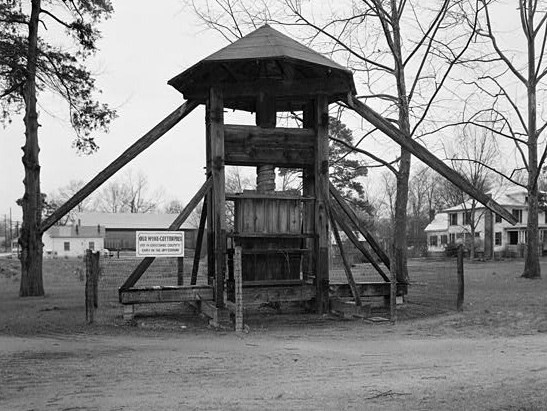
35°55′26″N 77°35′40″W / 35.92389°N 77.59444°WTarboro 8 Cotton Press 
February 18, 1971 Town Common
35°53′53″N 77°32′39″W / 35.89806°N 77.54417°WTarboro 9 Eastern Star Baptist Church April 2, 1980 Church and Wagner Sts.
35°53′36″N 77°31′50″W / 35.89333°N 77.53056°WTarboro 10 Edgecombe Agricultural Works April 2, 1980 Roughly bounded by Main, Howard, Albemarle, and Walnut Sts.
35°54′18″N 77°32′27″W / 35.905°N 77.54083°WTarboro 11 Edgemont Historic District November 12, 1999 500-800 blocks of Tarboro St., the 600-800 blocks of Hill St., and the southern side of the 600-800 blocks of Sycamore St.; also roughly bounded by Cokey Rd., George St., Eastern Ave., Edgewood St., and School St.
35°56′10″N 77°47′19″W / 35.93611°N 77.78861°WRocky Mount Second set of boundaries represents a boundary increase of September 14, 2002 12 The Grove February 18, 1971 130 Bridgers St.
35°54′10″N 77°32′14″W / 35.90278°N 77.53722°WTarboro 13 Howell Homeplace December 20, 1984 SR 1517
35°54′40″N 77°28′5″W / 35.91111°N 77.46806°WTarboro 14 Lone Pine November 6, 1987 SR 1207, S of US 64
35°54′48″N 77°36′9″W / 35.91333°N 77.6025°WTarboro 15 Mount Prospect November 20, 1974 Jct. of SR 1409 and SR 1428
36°0′27″N 77°38′29″W / 36.0075°N 77.64139°WLeggett Also known as Exum-Lewis House; burned[5] 16 Dr. A. B. Nobles House and McKendree Church June 19, 1980 NW of Mercer on SR 1224
35°52′12″N 77°39′26″W / 35.87°N 77.65722°WMercer 17 Oakland Plantation April 2, 1980 Edmondson St.
35°53′47″N 77°32′27″W / 35.89639°N 77.54083°WTarboro 18 Old Town Plantation December 1, 1983 Off NC 97
35°58′54.09″N 77°43′51.77″W / 35.9816917°N 77.7310472°WBattleboro 19 Piney Prospect February 18, 1971 5.7 miles S of Tarboro off SR 1601
35°48′49″N 77°34′1″W / 35.81361°N 77.56694°WTarboro 20 Porter Houses and Armstrong Kitchen September 14, 2002 821 Wells Rd.
36°3′55″N 77°40′1″W / 36.06528°N 77.66694°WWhitakers 21 Princeville School January 9, 2001 US 258, 0.3 miles E of NC 64
35°53′24″N 77°31′37″W / 35.89°N 77.52694°WPrinceville 22 Quigless Clinic October 27, 2000 99 Main St.
35°53′40″N 77°31′58″W / 35.89444°N 77.53278°WTarboro 23 Railroad Depot Complex April 2, 1980 Off N. Main St.
35°54′23″N 77°32′32″W / 35.90639°N 77.54222°WTarboro 24 Redmond-Shackelford House December 12, 1976 300 Main St.
35°53′46″N 77°32′8″W / 35.89611°N 77.53556°WTarboro 25 Rocky Mount Central City Historic District June 19, 1980 also portions of 26 blocks on Main, Washington, Church, Battle, Hammond, Hill, Howard, Ivy, Gay, Goldleaf, and Thomas Sts.
35°56′49.94″N 77°47′25.83″W / 35.9472056°N 77.7905083°WRocky Mount Present boundaries reflect a boundary increase and decrease of August 27, 2009; original boundaries were "roughly bounded by Robinson and Atlantic Aves. and Holly and Franklin Sts." 26 St. John's Episcopal Church February 18, 1971 E. Main St.
36°2′47″N 77°44′53″W / 36.04639°N 77.74806°WBattleboro 27 St. Paul Baptist Church April 2, 1980 Edmondson St.
35°58′41″N 77°31′54″W / 35.97806°N 77.53167°WTarboro 28 Tarboro Historic District April 2, 1980 Roughly bounded by Albemarle Ave., Walnut, Panola, and Water Sts., and River Rd.
35°53′44″N 77°32′15″W / 35.89556°N 77.5375°WTarboro 29 Tarboro Town Common September 30, 1970 Bounded by Wilson St., Albemarle Ave., Park Ave. and St. Patrick St.
35°53′53″N 77°32′9″W / 35.89806°N 77.53583°WTarboro 30 Upper Town Creek Rural Historic District August 29, 1986 Roughly bounded by NC 1003, NC 1411, NC 1414, and Town Creek
35°47′57″N 77°45′25″W / 35.79917°N 77.75694°WWilson 31 Vinedale July 15, 1982 SW of NC 42/43 and SR 1122
35°46′50″N 77°36′21″W / 35.78056°N 77.60583°WPinetops 32 Walston-Bulluck House February 18, 1971 1018 St. Andrews St.
35°54′10″N 77°32′14″W / 35.90278°N 77.53722°WTarboro 33 Wilkinson-Dozier House October 23, 1974 SE of Tarboro off SR 1524
35°51′52″N 77°26′13″W / 35.86444°N 77.43694°WConetoe 34 Worsley-Burnette House May 24, 1990 SR 1526 N of jct. with SR 1540
35°51′44″N 77°26′13″W / 35.86222°N 77.43694°WConetoe See also
- National Register of Historic Places listings in North Carolina
- List of National Historic Landmarks in North Carolina
References
- ^ The latitude and longitude information provided in this table was derived originally from the National Register Information System, which has been found to be fairly accurate for about 99% of listings. For about 1% of NRIS original coordinates, experience has shown that one or both coordinates are typos or otherwise extremely far off; some corrections may have been made. A more subtle problem causes many locations to be off by up to 150 yards, depending on location in the country: most NRIS coordinates were derived from tracing out latitude and longitudes off of USGS topographical quadrant maps created under the North American Datum of 1927, which differs from the current, highly accurate WGS84 GPS system used by Google maps. Chicago is about right, but NRIS longitudes in Washington are higher by about 4.5 seconds, and are lower by about 2.0 seconds in Maine. Latitudes differ by about 1.0 second in Florida. Some locations in this table may have been corrected to current GPS standards.
- ^ "National Register of Historic Places: Weekly List Actions". National Park Service, United States Department of the Interior. Retrieved on November 10, 2011.
- ^ Numbers represent an ordering by significant words. Various colorings, defined here, differentiate National Historic Landmark sites and National Register of Historic Places Districts from other NRHP buildings, structures, sites or objects.
- ^ "National Register Information System". National Register of Historic Places. National Park Service. 2008-04-24. http://nrhp.focus.nps.gov/natreg/docs/All_Data.html.
- ^ "North Carolina Listings in the National Register of Historic Places by County". North Carolina State Historic Preservation Office. 22 October 2008. http://www.hpo.ncdcr.gov/nrlist.htm. Retrieved 14 July 2009.
U.S. National Register of Historic Places Topics Lists by states Alabama • Alaska • Arizona • Arkansas • California • Colorado • Connecticut • Delaware • Florida • Georgia • Hawaii • Idaho • Illinois • Indiana • Iowa • Kansas • Kentucky • Louisiana • Maine • Maryland • Massachusetts • Michigan • Minnesota • Mississippi • Missouri • Montana • Nebraska • Nevada • New Hampshire • New Jersey • New Mexico • New York • North Carolina • North Dakota • Ohio • Oklahoma • Oregon • Pennsylvania • Rhode Island • South Carolina • South Dakota • Tennessee • Texas • Utah • Vermont • Virginia • Washington • West Virginia • Wisconsin • WyomingLists by territories Lists by associated states Other Municipalities and communities of Edgecombe County, North Carolina City 
Towns Conetoe | Leggett | Macclesfield | Pinetops | Princeville | Sharpsburg‡ | Speed | Tarboro | Whitakers‡
Unincorporated
communityFootnotes ‡This populated place also has portions in an adjacent county or counties
Categories:- Edgecombe County, North Carolina
- National Register of Historic Places in North Carolina
- Buildings and structures in Edgecombe County, North Carolina
-


Wikimedia Foundation. 2010.