- National Register of Historic Places listings in Ellis County, Texas
-
List of Registered Historic Places in Ellis County, Texas
This is intended to be a complete list of properties and districts listed on the National Register of Historic Places in Ellis County, Texas. The locations of National Register properties and districts (at least for all showing latitude and longitude coordinates below) may be seen in a Google map by clicking on "Map of all coordinates".[1]
-
- This National Park Service list is complete through NPS recent listings posted November 10, 2011.[2]
[3] Landmark name [4] Image Date listed Location City or town Summary 1 F. R. Adamson House September 24, 1986 309 University
32°24′06″N 96°51′14″W / 32.401667°N 96.853889°WWaxahachie 2 J. M. Alderdice House 
September 24, 1986 1500 W. Main
32°23′52″N 96°51′49″W / 32.397778°N 96.863611°WWaxahachie 3 G. H. Alderman House September 24, 1986 317 E. Marvin
31°56′35″N 96°51′28″W / 31.943056°N 96.857778°WWaxahachie 4 I. R. Allen House September 25, 1986 601 N. Dallas
32°19′52″N 96°37′51″W / 32.331111°N 96.630833°WEnnis 5 E. K. Atwood House September 25, 1986 605 N. Preston
32°19′47″N 96°38′01″W / 32.329722°N 96.633611°WEnnis 6 Barkley-Floyd House September 25, 1986 709 N. Dallas
32°19′57″N 96°37′53″W / 32.3325°N 96.631389°WEnnis 7 Barrington House September 25, 1986 206 W. Belknap
32°19′46″N 96°37′48″W / 32.329444°N 96.63°WEnnis 8 J. S. Berry House September 24, 1986 201 E. University
32°23′58″N 96°51′14″W / 32.399444°N 96.853889°WWaxahachie 9 E. T. Boren House September 25, 1986 616 W. Denton
32°19′44″N 96°38′08″W / 32.328889°N 96.635556°WEnnis 10 Building at 441 East Main September 24, 1986 441 E. Main
32°23′01″N 96°50′30″W / 32.383611°N 96.841667°WWaxahachie 11 Building at 500-502 East Main September 24, 1986 500-502 E. Main
32°23′02″N 96°50′32″W / 32.383889°N 96.842222°WWaxahachie 12 T. J. Bullard House September 24, 1986 221 Patrick
32°23′43″N 96°51′19″W / 32.395278°N 96.855278°WWaxahachie 13 Central Presbyterian Church 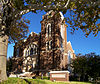
September 11, 1987 402 N. College
32°23′21″N 96°50′41″W / 32.389167°N 96.844722°WWaxahachie 14 Oscar H. Chapman House September 24, 1986 201 Overhill
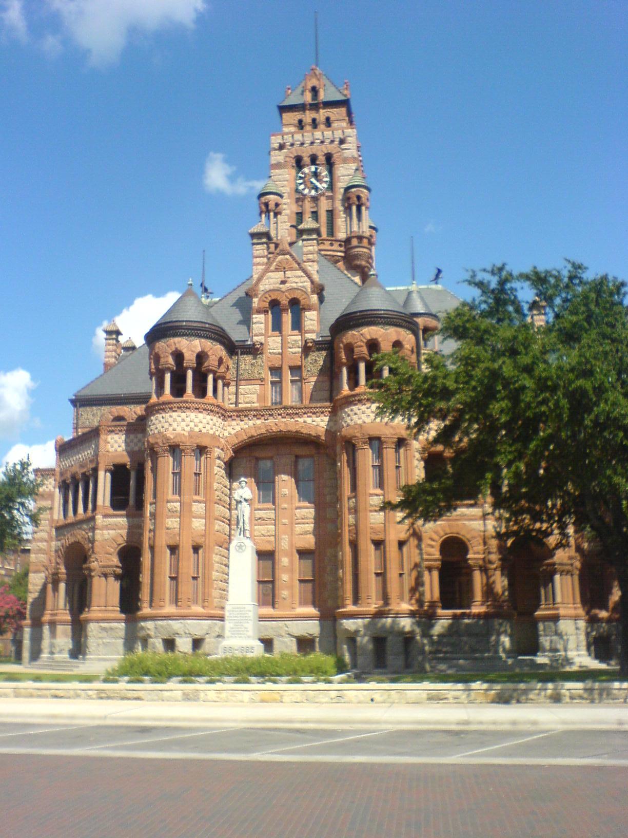
32°24′14″N 96°50′43″W / 32.403889°N 96.845278°WWaxahachie 15 Joe Cohn House 
September 24, 1986 501 Sycamore
32°23′58″N 96°50′43″W / 32.399444°N 96.845278°WWaxahachie 16 Cole-Hipp House September 24, 1986 309 E. Marvin
32°23′29″N 96°50′27″W / 32.391389°N 96.840833°WWaxahachie 17 Coleman-Cole House September 24, 1986 1219 E. Marvin
31°56′14″N 96°50′30″W / 31.937222°N 96.841667°WWaxahachie 18 Roy Connally House September 24, 1986 205 E. University
32°23′59″N 96°51′13″W / 32.399722°N 96.853611°WWaxahachie 19 George C. Dillon House September 24, 1986 123 E. University
32°23′56″N 96°51′15″W / 32.398889°N 96.854167°WWaxahachie 20 G. G. Dunkerly House September 25, 1986 607 W. Baylor
32°19′35″N 96°37′59″W / 32.326389°N 96.633056°WEnnis 21 D. D. Eastham House September 24, 1986 401 E. Marvin
31°56′34″N 96°51′25″W / 31.942778°N 96.856944°WWaxahachie 22 Ellis County Courthouse Historic District 
April 23, 1975 Roughly bounded by both sides of Waxahachie Creek N to Union Pacific RR tracks & between both sides of Elm and Flat Sts.
32°23′02″N 96°50′55″W / 32.383889°N 96.848611°WWaxahachie 23 Ennis Commercial Historic District September 25, 1986 Roughly bounded by W. Baylor, N. Main, W. Crockett, and McKinney Sts.
32°19′41″N 96°37′35″W / 32.328056°N 96.626389°WEnnis 24 Ennis Cotton Compress September 25, 1986 111 E. Lampasas
32°19′24″N 96°37′22″W / 32.323333°N 96.622778°WEnnis 25 Ennis High School September 25, 1986 501 N. Gaines
32°19′42″N 96°38′03″W / 32.328333°N 96.634167°WEnnis 26 J. R. Erwin House 
September 24, 1986 414 W. Marvin
32°23′39″N 96°50′52″W / 32.394167°N 96.847778°WWaxahachie 27 Fain House September 25, 1986 403 N. Preston
32°19′42″N 96°37′58″W / 32.328333°N 96.632778°WEnnis 28 Farrar House September 25, 1986 601 S. Main W
32°19′16″N 96°37′19″W / 32.321111°N 96.621944°WEnnis 29 Ferris School 
December 6, 1990 411 Gibson
32°23′11″N 96°50′36″W / 32.386389°N 96.843333°WWaxahachie 30 W. B. Forrest House September 24, 1986 500 Royal
31°56′28″N 96°51′40″W / 31.941111°N 96.861111°WWaxahachie 31 Dr. L. H. Graham House 
September 24, 1986 909 W. Marvin
32°23′46″N 96°51′11″W / 32.396111°N 96.853056°WWaxahachie 32 Highway Garage 
April 18, 2003 315 W. Main
32°23′11″N 96°50′56″W / 32.386389°N 96.848889°WWaxahachie 33 E. M. Hines House September 24, 1986 124 Kaufman
32°23′07″N 96°50′35″W / 32.385278°N 96.843056°WWaxahachie 34 House at 104 Kaufman September 24, 1986 104 Kaufman
32°23′05″N 96°50′38″W / 32.384722°N 96.843889°WWaxahachie 35 House at 106 East Denton September 25, 1986 106 E. Denton
32°19′57″N 96°37′42″W / 32.3325°N 96.628333°WEnnis 36 House at 106 Kaufman September 24, 1986 106 Kaufman
32°23′06″N 96°50′37″W / 32.385°N 96.843611°WWaxahachie 37 House at 111 Brown September 24, 1986 111 Brown
32°23′36″N 96°50′37″W / 32.393333°N 96.843611°WWaxahachie 38 House at 111 Williams September 24, 1986 111 Williams
32°23′19″N 96°50′29″W / 32.388611°N 96.841389°WWaxahachie 39 House at 113 East Ross September 24, 1986 113 E. Ross
32°23′44″N 96°50′26″W / 32.395556°N 96.840556°WWaxahachie 40 House at 1301 East Marvin September 24, 1986 1301 E. Marvin
31°56′15″N 96°50′27″W / 31.9375°N 96.840833°WWaxahachie 41 House at 1423 Sycamore September 24, 1986 1423 Sycamore
32°24′15″N 96°51′26″W / 32.404167°N 96.857222°WWaxahachie 42 House at 301 Turner September 24, 1986 301 Turner
32°22′50″N 96°51′16″W / 32.380556°N 96.854444°WWaxahachie 43 House at 320 East Marvin September 24, 1986 320 E. Marvin
32°23′26″N 96°50′25″W / 32.390556°N 96.840278°WWaxahachie 44 House at 404 East Crockett September 25, 1986 404 E. Crockett
32°19′42″N 96°37′25″W / 32.328333°N 96.623611°WEnnis 45 House at 418 North College September 24, 1986 418 N. College
32°23′24″N 96°50′39″W / 32.39°N 96.844167°WWaxahachie 46 House at 500 North Main, East September 25, 1986 500 N. Main E
32°19′54″N 96°37′42″W / 32.331667°N 96.628333°WEnnis 47 House at 501 North Grand 
September 24, 1986 501 N. Grand
32°24′09″N 96°51′31″W / 32.4025°N 96.858611°WWaxahachie 48 House at 508 North Dallas September 25, 1986 508 N. Dallas
32°19′51″N 96°37′48″W / 32.330833°N 96.63°WEnnis 49 House at 509 West Brown September 25, 1986 509 W. Brown
32°19′28″N 96°37′51″W / 32.324444°N 96.630833°WEnnis 50 House at 512 North Grand September 24, 1986 512 N. Grand
32°24′03″N 96°51′32″W / 32.400833°N 96.858889°WWaxahachie 51 House at 523 Highland September 24, 1986 523 Highland
32°24′04″N 96°51′25″W / 32.401111°N 96.856944°WWaxahachie 52 House at 625 Cantrell September 24, 1986 625 Cantrell
32°22′51″N 96°51′15″W / 32.380833°N 96.854167°WWaxahachie 53 House at 700 South Rogers September 24, 1986 700 S. Rogers
32°22′45″N 96°51′15″W / 32.379167°N 96.854167°WWaxahachie 54 House at 703 South College September 24, 1986 703 S. College
32°22′41″N 96°51′12″W / 32.378056°N 96.853333°WWaxahachie 55 House at 708 East Brown September 25, 1986 708 E. Brown
32°19′50″N 96°37′10″W / 32.330556°N 96.619444°WEnnis 56 House at 712 East Marvin September 24, 1986 712 E. Marvin
32°23′17″N 96°50′05″W / 32.388056°N 96.834722°WWaxahachie 57 House at 722 West Madison September 25, 1986 722 W. Madison
32°18′59″N 96°37′43″W / 32.316389°N 96.628611°WEnnis 58 House at 802 East Ennis September 25, 1986 802 E. Ennis
32°19′53″N 96°37′12″W / 32.331389°N 96.62°WEnnis 59 House at 803 Cantrell September 24, 1986 803 Cantrell
32°22′52″N 96°51′23″W / 32.381111°N 96.856389°WWaxahachie 60 House at 806 South Dallas September 25, 1986 806 S. Dallas
32°19′16″N 96°37′19″W / 32.321111°N 96.621944°WEnnis 61 House at 807 North Preston September 25, 1986 807 N. Preston
32°19′58″N 96°38′06″W / 32.332778°N 96.635°WEnnis 62 House at 810 North Preston September 25, 1986 810 N. Preston
32°19′56″N 96°38′05″W / 32.332222°N 96.634722°WEnnis 63 House at 816 Cantrell September 24, 1986 816 Cantrell
32°22′55″N 96°51′16″W / 32.381944°N 96.854444°WWaxahachie 64 House at 816 West Water September 24, 1986 816 W. Water
31°56′26″N 96°51′52″W / 31.940556°N 96.864444°WWaxahachie 65 House at 901 Cantrell September 24, 1986 901 Cantrell
32°22′49″N 96°51′39″W / 32.380278°N 96.860833°WWaxahachie 66 Jolesch House September 25, 1986 504 W. Knox
32°19′36″N 96°37′55″W / 32.326667°N 96.631944°WEnnis 67 Joshua Chapel A.M.E. Church September 24, 1986 110 Ailen
32°22′52″N 96°50′45″W / 32.381111°N 96.845833°WWaxahachie 68 J. D. Kirven House September 24, 1986 601 Sycamore
32°24′01″N 96°50′48″W / 32.400278°N 96.846667°WWaxahachie 69 William Koger House September 24, 1986 409 Kaufman
32°23′15″N 96°50′23″W / 32.3875°N 96.839722°WWaxahachie 70 Samuel Langsford House September 24, 1986 1208 E. Marvin
32°23′18″N 96°49′41″W / 32.388333°N 96.828056°WWaxahachie 71 William Lewis House September 24, 1986 1201 E. Marvin
32°23′19″N 96°49′44″W / 32.388611°N 96.828889°WWaxahachie 72 Matthews-Atwood House September 25, 1986 307 N. Sherman
32°19′42″N 96°37′53″W / 32.328333°N 96.631389°WEnnis 73 Matthews-Templeton House September 25, 1986 606 W. Denton
32°19′45″N 96°38′07″W / 32.329167°N 96.635278°WEnnis 74 McCanless-Williams House September 25, 1986 402 W. Tyler
32°19′55″N 96°38′03″W / 32.331944°N 96.634167°WEnnis 75 McCartney House 
September 24, 1986 603 W. Marvin
32°23′41″N 96°51′00″W / 32.394722°N 96.85°WWaxahachie 76 Meredith-McDowal House September 25, 1986 701 N. Gaines
32°19′48″N 96°38′06″W / 32.33°N 96.635°WEnnis 77 Moore House September 25, 1986 400 W. Denton
32°19′49″N 96°37′58″W / 32.330278°N 96.632778°WEnnis 78 W. B. Moore House September 24, 1986 912 E. Marvin
32°23′15″N 96°49′56″W / 32.3875°N 96.832222°WWaxahachie 79 Morton House September 25, 1986 1007 N. McKinney
32°20′03″N 96°38′02″W / 32.334167°N 96.633889°WEnnis 80 National Compress Company Building September 11, 1987 503 S. Flat
32°22′52″N 96°50′45″W / 32.381111°N 96.845833°WWaxahachie 81 Neal House September 25, 1986 704 N. Preston
32°19′52″N 96°38′02″W / 32.331111°N 96.633889°WEnnis 82 North Rogers Street Historic District 
September 24, 1986 500-600 blks. of N. Rogers, 500-600 blks. of N. Monroe, and 100-200 blks. of W. Marvin Sts.
32°23′27″N 96°50′45″W / 32.390833°N 96.845833°WWaxahachie 83 Joe Novy House September 25, 1986 401 N. Clay
32°19′37″N 96°38′05″W / 32.326944°N 96.634722°WEnnis 84 Old City Mills September 25, 1986 212 E. Ennis and 108 E. Brown
32°19′41″N 96°37′32″W / 32.328056°N 96.625556°WEnnis 85 Oldham Avenue Historic District September 24, 1986 Oldham Ave. between N. Jackson and Bethel Sts.
32°23′16″N 96°50′32″W / 32.387778°N 96.842222°WWaxahachie 86 Mary and Frank Oldham House 
September 24, 1986 910 W. Marvin
32°23′48″N 96°51′11″W / 32.396667°N 96.853056°WWaxahachie 87 Paillet House September 24, 1986 800 S. College
32°22′40″N 96°51′17″W / 32.377778°N 96.854722°WWaxahachie 88 Marshall T. Patrick House 
September 24, 1986 233 Patrick
32°23′43″N 96°51′18″W / 32.395278°N 96.855°WWaxahachie 89 M. S. Payne House September 24, 1986 521 N. Grand
32°24′15″N 96°51′30″W / 32.404167°N 96.858333°WWaxahachie 90 E. F. Phillips House September 24, 1986 902 W. Marvin
32°23′47″N 96°51′09″W / 32.396389°N 96.8525°WWaxahachie 91 Plumhoff House September 24, 1986 612 S. Rogers
32°22′47″N 96°51′11″W / 32.379722°N 96.853056°WWaxahachie 92 Mary Ralston House September 24, 1986 116 E. University
32°23′54″N 96°51′13″W / 32.398333°N 96.853611°WWaxahachie 93 Ransom House September 25, 1986 501 N. McKinney
32°19′48″N 96°37′53″W / 32.33°N 96.631389°WEnnis 94 Raphael House September 25, 1986 500 W. Ennis
32°19′33″N 96°37′52″W / 32.325833°N 96.631111°WEnnis 95 M. B. Ray House 
September 24, 1986 401 N. Monroe
32°23′22″N 96°50′52″W / 32.389444°N 96.847778°WWaxahachie 96 W. B. Reinmiller House September 24, 1986 206 E. Marvin
32°23′28″N 96°50′32″W / 32.391111°N 96.842222°WWaxahachie 97 Paris Q. Rockett House September 24, 1986 321 E. University
32°24′07″N 96°51′09″W / 32.401944°N 96.8525°WWaxahachie 98 Rosemont House July 8, 1982 701 S. Rogers
32°22′44″N 96°51′13″W / 32.378889°N 96.853611°WWaxahachie 99 Saint Paul's Episcopal Church 
September 24, 1986 308 N. Monroe
32°23′18″N 96°50′12″W / 32.388333°N 96.836667°WWaxahachie 100 James S. Sanderson House September 25, 1986 201 N. Gaines
32°19′38″N 96°37′57″W / 32.327222°N 96.6325°WEnnis 101 Second Trinity University Campus September 11, 1987 1200 blk. of Sycamore
32°24′15″N 96°51′11″W / 32.404167°N 96.853056°WWaxahachie 102 Sharp House September 25, 1986 208 N. Gaines
32°19′37″N 96°37′55″W / 32.326944°N 96.631944°WEnnis 103 O. B. Sims House September 24, 1986 1408 W. Main
32°23′52″N 96°51′48″W / 32.397778°N 96.863333°WWaxahachie 104 John Solon House September 11, 1987 617 Solon Rd.
32°23′26″N 96°51′12″W / 32.390556°N 96.853333°WWaxahachie 105 Jesse and Mary Story House September 25, 1986 510 W. Brown
32°19′30″N 96°37′50″W / 32.325°N 96.630556°WEnnis 106 Strickland-Sawyer House October 18, 1984 500 Oldham St.
32°23′14″N 96°50′30″W / 32.387222°N 96.841667°WWaxahachie 107 Telfair House September 25, 1986 209 N. Preston
32°19′38″N 96°37′55″W / 32.327222°N 96.631944°WEnnis 108 Judge M. B. Templeton House 
September 24, 1986 203 N. Grand
32°23′53″N 96°51′43″W / 32.398056°N 96.861944°WWaxahachie 109 D. H. Thompson House September 24, 1986 312 Kaufman
32°23′11″N 96°50′27″W / 32.386389°N 96.840833°WWaxahachie 110 Trippet-Shive House 
September 24, 1986 209 N. Grand
32°23′57″N 96°51′39″W / 32.399167°N 96.860833°WWaxahachie 111 Richard Vickery House September 25, 1986 1104 E. Marvin
32°23′17″N 96°49′45″W / 32.388056°N 96.829167°WWaxahachie 112 Waxahachie Chautauqua Building May 3, 1974 Getzendaner Park
32°23′41″N 96°51′59″W / 32.394722°N 96.866389°WWaxahachie 113 Waxahachie Lumber Company September 11, 1987 123 Kaufman
32°23′09″N 96°50′37″W / 32.385833°N 96.843611°WWaxahachie 114 Weatherford House September 25, 1986 501 N. Preston
32°19′44″N 96°38′00″W / 32.328889°N 96.633333°WEnnis 115 John M. Weekley House September 25, 1986 510 W. Denton
32°19′46″N 96°38′03″W / 32.329444°N 96.634167°WEnnis 116 West End Historic District 
September 24, 1986 Roughly bounded by Central, W. Water, Monroe, Madison and W. Jefferson
32°23′26″N 96°51′22″W / 32.390556°N 96.856111°WWaxahachie 117 Porter L. Williams House September 24, 1986 200 E. University
32°23′57″N 96°51′11″W / 32.399167°N 96.853056°WWaxahachie 118 Williams-Erwin House 
July 7, 1978 412 W. Marvin St.
32°23′40″N 96°50′52″W / 32.394444°N 96.847778°WWaxahachie 119 Pat Witten House September 24, 1986 204 Brown
32°23′41″N 96°50′33″W / 32.394722°N 96.8425°WWaxahachie 120 Wyatt Street Shotgun House Historic District September 24, 1986 E side 300 blk. of Wyatt St.
32°23′05″N 96°50′21″W / 32.384722°N 96.839167°WWaxahachie See also
- Registered Historic Places in Texas, Counties D-G
References
- ^ The latitude and longitude information provided in this table was derived originally from the National Register Information System, which has been found to be fairly accurate for about 99% of listings. For about 1% of NRIS original coordinates, experience has shown that one or both coordinates are typos or otherwise extremely far off; some corrections may have been made. A more subtle problem causes many locations to be off by up to 150 yards, depending on location in the country: most NRIS coordinates were derived from tracing out latitude and longitudes off of USGS topographical quadrant maps created under North American Datum of 1927, which differs from the current, highly accurate GPS system used by Google maps. Chicago is about right, but NRIS longitudes in Washington are higher by about 4.5 seconds, and are lower by about 2.0 seconds in Maine. Latitudes differ by about 1.0 second in Florida. Some locations in this table may have been corrected to current GPS standards.
- ^ "National Register of Historic Places: Weekly List Actions". National Park Service, United States Department of the Interior. Retrieved on November 10, 2011.
- ^ Numbers represent an ordering by significant words. Various colorings, defined here, differentiate National Historic Landmark sites and National Register of Historic Places Districts from other NRHP buildings, structures, sites or objects.
- ^ "National Register Information System". National Register of Historic Places. National Park Service. . http://nrhp.focus.nps.gov/natreg/docs/All_Data.html.
U.S. National Register of Historic Places Topics Lists by states Alabama • Alaska • Arizona • Arkansas • California • Colorado • Connecticut • Delaware • Florida • Georgia • Hawaii • Idaho • Illinois • Indiana • Iowa • Kansas • Kentucky • Louisiana • Maine • Maryland • Massachusetts • Michigan • Minnesota • Mississippi • Missouri • Montana • Nebraska • Nevada • New Hampshire • New Jersey • New Mexico • New York • North Carolina • North Dakota • Ohio • Oklahoma • Oregon • Pennsylvania • Rhode Island • South Carolina • South Dakota • Tennessee • Texas • Utah • Vermont • Virginia • Washington • West Virginia • Wisconsin • WyomingLists by territories Lists by associated states Other  Category:National Register of Historic Places •
  Portal:National Register of Historic PlacesCategories:
- Ellis County, Texas
- National Register of Historic Places in Texas
- Buildings and structures in Ellis County, Texas
-


Wikimedia Foundation. 2010.