- National Register of Historic Places listings in Fairfax County, Virginia
-
This list includes properties and districts listed on the National Register of Historic Places in Fairfax County, Virginia. Click the "Map of all coordinates" link to the right to view a Google map of all properties and districts with latitude and longitude coordinates in the table below.[1]
Current listings
-
- This National Park Service list is complete through NPS recent listings posted November 10, 2011.[2]
[3] Landmark name [4] Image Date listed Location City or town Summary 1 "A" Fort and Battery Hill Redoubt-Camp Early October 30, 1998 Balmoral Greens Ave., 1 mi S. of jct. with Compton Rd.
38°47′22″N 77°25′40″W / 38.789444°N 77.427778°WManassas Park 2 Belvoir Mansion Ruins and the Fairfax Grave 
June 4, 1973 SE of intersection of 23rd St. and Belvoir Rd.
38°41′10″N 77°07′56″W / 38.686114°N 77.132131°WFort Belvoir 3 A. Smith Bowman Distillery 
December 9, 1999 1875 Old Reston Ave.
38°57′27″N 77°21′11″W / 38.9575°N 77.353056°WReston 4 Clifton Historic District August 15, 1985 Roughly bounded by Popes Head Creek, Water St., Dell Ave., Chestnut & Chapel Rds.
38°46′46″N 77°23′11″W / 38.779444°N 77.386389°WClifton 5 Colvin Run Mill 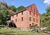
August 16, 1977 S of Great Falls at 10017 Colvin Run Rd.
38°58′08″N 77°17′38″W / 38.968889°N 77.293889°WGreat Falls 6 Cornwell Farm April 13, 1977 SE of Great Falls, 9414 Georgetown Pike
38°59′29″N 77°16′18″W / 38.991389°N 77.271667°WGreat Falls 7 D.C. Workhouse and Reformatory Historic District 
February 16, 2006 Bet. Silverbrook Rd., Lorton Rd., Ox Rd., and Furnace Rd.
38°42′03″N 77°14′41″W / 38.700833°N 77.244722°WLorton 8 Dranesville Tavern 
November 9, 1972 11919 Leesburg Pike
39°00′28″N 77°21′38″W / 39.007778°N 77.360556°WDranesville 9 Fairfax Arms 
May 21, 1979 10712 Old Colchester Rd.
38°40′07″N 77°14′08″W / 38.668611°N 77.235556°WColchester 10 Floris Historic District August 12, 2010 Bounded by Centreville Rd., W. Ox Rd., Monroe St., and Frying Pan Branch
38°56′17″N 77°24′27″W / 38.938056°N 77.4075°WHerndon 11 Fort Hunt 
March 26, 1980 Mount Vernon Memorial Hwy.
38°42′56″N 77°03′02″W / 38.715556°N 77.050556°WAlexandria 12 Four Stairs August 11, 2004 840 Leigh Mill Rd.
38°59′10″N 77°16′35″W / 38.986111°N 77.276389°WGreat Falls 13 Frying Pan Meetinghouse February 5, 1991 2615 Centreville Rd.
38°56′24″N 77°24′48″W / 38.94°N 77.413333°WFloris 14 George Washington Memorial Parkway 
June 2, 1995 Roughly, S side of the Potomac R. from American Legion to Memorial Bridge and N side from Brickyard Rd. to Chain Bridge
38°56′19″N 77°08′07″W / 38.938611°N 77.135278°WLangley 15 Great Falls Grange Hall and Forestville School August 11, 2004 9812 and 9818 Georgetown Pike
38°59′58″N 77°17′10″W / 38.999444°N 77.286111°WGreat Falls 16 Green Spring 
October 22, 2003 4601 Green Spring Rd.
38°49′27″N 77°09′24″W / 38.824167°N 77.156667°WAlexandria 17 John Gunnell House November 27, 2006 489 Arnon Meadow Rd.
39°00′55″N 77°17′23″W / 39.015278°N 77.289722°WGreat Falls 18 William Gunnell House May 22, 2003 600 Insbruck Ave.
39°00′14″N 77°17′06″W / 39.003889°N 77.285°WGreat Falls 19 Gunston Hall 
October 15, 1966 10709 Gunston Rd.
38°39′46″N 77°09′39″W / 38.662778°N 77.160833°WMason Neck 20 Herndon Depot June 18, 1979 Elden St.
38°58′11″N 77°23′10″W / 38.969722°N 77.386111°WHerndon 21 Herndon Historic District January 11, 1991 Roughly bounded by Locust, Spring, Pearl, Monroe, Station and Vine Sts.
38°58′06″N 77°23′05″W / 38.968333°N 77.384722°WHerndon 22 Holmes Run Acres Historic District 
March 22, 2007 Area generally bounded by Gallows Rd., Surrey Ln, and Holmes Run Dr.
38°51′09″N 77°12′38″W / 38.852514°N 77.210519°WFalls Church 23 Hope Park Mill and Miller's House 
August 15, 1977 12124 Pope's Head Rd.
38°48′51″N 77°22′00″W / 38.814167°N 77.366667°WFairfax 24 Huntley 
November 3, 1972 6918 Harrison Lane
38°45′56″N 77°05′43″W / 38.765556°N 77.095278°WAlexandria 25 Langley Fork Historic District October 19, 1982 Jct. of Georgetown Pike and Old Chain Bridge Rd.
38°56′46″N 77°09′36″W / 38.946111°N 77.16°WLangley 26 Manassas National Battlefield Park 
October 15, 1966 NW of Manassas off VA 215
38°52′15″N 77°32′44″W / 38.87083°N 77.54556°WManassas 27 Merrybrook 
April 26, 2007 2346 Centreville Rd.
38°57′20″N 77°24′31″W / 38.955556°N 77.408611°WHerndon 28 Mount Vernon 
October 15, 1966 7 mi. S of Alexandria on George Washington Memorial Pkwy.
38°42′43″N 77°05′13″W / 38.711944°N 77.086944°WAlexandria 29 Mount Vernon Memorial Highway 
May 18, 1981 Washington St. and George Washington Memorial Pkwy.
38°46′35″N 77°03′13″W / 38.776389°N 77.053611°WMcLean 30 Northwest No. 3 Boundary Marker of the Original District of Columbia February 1, 1991 4013 N. Tazewell St.
38°55′29″N 77°07′59″W / 38.924722°N 77.133056°WArlington 31 Oak Hill May 19, 2004 4716 Wakefield Chapel Rd.
38°49′15″N 77°14′25″W / 38.820833°N 77.240278°WAnnandale 32 Oakton Trolley Station February 8, 1995 2923 Gray St.
38°52′47″N 77°17′49″W / 38.879722°N 77.296944°WOakton 33 Pohick Church 
October 16, 1969 9201 Richmond Hwy.
38°42′28″N 77°11′39″W / 38.707778°N 77.194167°WLorton 34 Pope-Leighey House 
December 18, 1970 E of Accotink off U.S. 1
38°43′10″N 77°08′11″W / 38.719444°N 77.136389°WAccotink 35 Potomac Canal Historic District 
October 18, 1979 E of Great Falls
38°59′47″N 77°15′11″W / 38.996389°N 77.253056°WGreat Falls 36 Salona July 24, 1973 1214 Buchanan St.
38°56′18″N 77°10′09″W / 38.938333°N 77.169167°WMcLean 37 Silverbook Methodist Church January 16, 2004 8616 Silverbrood Rd., Virginia 600
38°43′32″N 77°14′35″W / 38.725556°N 77.243056°WLorton 38 Southwest No. 6 Boundary Marker of the Original District of Columbia February 1, 1991 S. Jefferson St. S of jct. with Columbia Pike, in median strip
38°51′06″N 77°07′06″W / 38.851667°N 77.118333°WBailey's Crossroads 39 Southwest No. 7 Boundary Marker of the Original District of Columbia February 1, 1991 Behind 3101 S. Manchester St.
38°51′44″N 77°08′00″W / 38.862222°N 77.133333°WFairfax 40 Southwest No. 8 Boundary Marker of the Original District of Columbia February 1, 1991 Jct. of Wilson Blvd. and John Marshall Dr., behind apt. bldg.
38°52′14″N 77°08′46″W / 38.870556°N 77.146111°WArlington 41 Spring Hill Farm November 22, 2002 1121 Spring Hill Rd.
38°56′53″N 77°13′30″W / 38.948136°N 77.22505°WMcLean 42 St. Mary's Church July 1, 1976 5605 Vogue Rd.
38°48′08″N 77°19′37″W / 38.802222°N 77.326944°WFairfax Station 43 Sully 
December 18, 1970 N of jct. of Rtes. 28 and U.S. 50
38°54′29″N 77°25′56″W / 38.908056°N 77.432222°WChantilly 44 Taft Archeological Site#029-5411 August 11, 2004 Address Restricted
38°38′55″N 77°11′40″W / 38.648611°N 77.194444°WLorton 45 Tauxemont Historic District February 9, 2006 Bet. Ft. Hunt Rd. and Accotink Place, inc. Shenandoah, Tauxemont, Namassin, Westmoreland and Gahant Rds. and Bolling
38°44′37″N 77°03′14″W / 38.7436°N 77.053897°WAlexandria 46 Tower House May 2, 2006 9066 Tower House Place
38°42′41″N 77°04′02″W / 38.711389°N 77.067222°WAlexandria 47 Vale School-Community House June 8, 2011 3124 Fox Mill Rd.
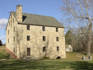
38°53′29″N 77°20′56″W / 38.891389°N 77.348889°WOakton 48 George Washington's Gristmill 
August 8, 2003 5512 Mount Vernon Memorial Hwy.
38°42′46″N 77°07′51″W / 38.712778°N 77.130833°WLorton 49 West Cornerstone February 1, 1991 W side Meridian St., S of jct. with Williamsburg Blvd.
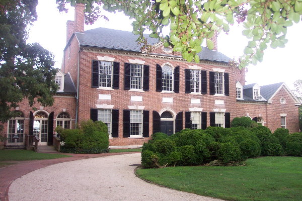
38°53′33″N 77°10′21″W / 38.8925°N 77.1725°WFalls Church 50 Woodlawn Plantation 
February 26, 1970 W of jct. of U.S. 1 and Rte. 235
38°43′00″N 77°08′10″W / 38.716667°N 77.136111°WAlexandria 51 Woodlawn Quaker Meetinghouse May 21, 2009 8990 Woodlawn Rd.
38°42′51″N 77°08′33″W / 38.714167°N 77.1425°WFort Belvoir See also
- National Register of Historic Places listings in Virginia
- National Register of Historic Places listings in Alexandria, Virginia
- National Register of Historic Places listings in Fairfax, Virginia
- List of National Historic Landmarks in Virginia
References
- ^ The latitude and longitude information provided in this table was derived originally from the National Register Information System, which has been found to be fairly accurate for about 99% of listings. For about 1% of NRIS original coordinates, experience has shown that one or both coordinates are typos or otherwise extremely far off; some corrections may have been made. A more subtle problem causes many locations to be off by up to 150 yards, depending on location in the country: most NRIS coordinates were derived from tracing out latitude and longitudes off of USGS topographical quadrant maps created under North American Datum of 1927, which differs from the current, highly accurate GPS system used by Google maps. Chicago is about right, but NRIS longitudes in Washington are higher by about 4.5 seconds, and are lower by about 2.0 seconds in Maine. Latitudes differ by about 1.0 second in Florida. Some locations in this table may have been corrected to current GPS standards.
- ^ "National Register of Historic Places: Weekly List Actions". National Park Service, United States Department of the Interior. Retrieved on November 10, 2011.
- ^ Numbers represent an ordering by significant words. Various colorings, defined here, differentiate National Historic Landmark sites and National Register of Historic Places Districts from other NRHP buildings, structures, sites or objects.
- ^ "National Register Information System". National Register of Historic Places. National Park Service. . http://nrhp.focus.nps.gov/natreg/docs/All_Data.html.
U.S. National Register of Historic Places Topics Lists by states Alabama • Alaska • Arizona • Arkansas • California • Colorado • Connecticut • Delaware • Florida • Georgia • Hawaii • Idaho • Illinois • Indiana • Iowa • Kansas • Kentucky • Louisiana • Maine • Maryland • Massachusetts • Michigan • Minnesota • Mississippi • Missouri • Montana • Nebraska • Nevada • New Hampshire • New Jersey • New Mexico • New York • North Carolina • North Dakota • Ohio • Oklahoma • Oregon • Pennsylvania • Rhode Island • South Carolina • South Dakota • Tennessee • Texas • Utah • Vermont • Virginia • Washington • West Virginia • Wisconsin • WyomingLists by territories Lists by associated states Other  Category:National Register of Historic Places •
  Portal:National Register of Historic PlacesCategories:
- Fairfax County, Virginia
- National Register of Historic Places in Virginia
- Virginia-related lists
-


Wikimedia Foundation. 2010.