- National Register of Historic Places listings in Fayette County, Indiana
-
 Location of Fayette County in Indiana
This is a list of the National Register of Historic Places listings in Fayette County, Indiana.
This is intended to be a complete list of the properties on the National Register of Historic Places in Fayette County, Indiana, United States. Latitude and longitude coordinates are provided for many National Register properties; these locations may be seen together in a Google map.[1]
There are 5 properties listed on the National Register in the county.
-
- This National Park Service list is complete through NPS recent listings posted November 10, 2011.[2]
Current listings
[3] Landmark name [4] Image Date listed Location City or town Summary 1 Canal House 
July 16, 1973 111 E. 4th St.
39°38′24″N 85°08′22″W / 39.64°N 85.139444°WConnersville 2 Elmhurst April 11, 1977 South of Connersville on State Road 121
39°37′53″N 85°08′45″W / 39.631389°N 85.145833°WConnersville 3 Fayette County Courthouse 
September 27, 2006 401 Central Ave.
39°38′27″N 85°08′26″W / 39.640833°N 85.140556°WConnersville 4 William Lowry House 
February 11, 1982 Kniese Rd.
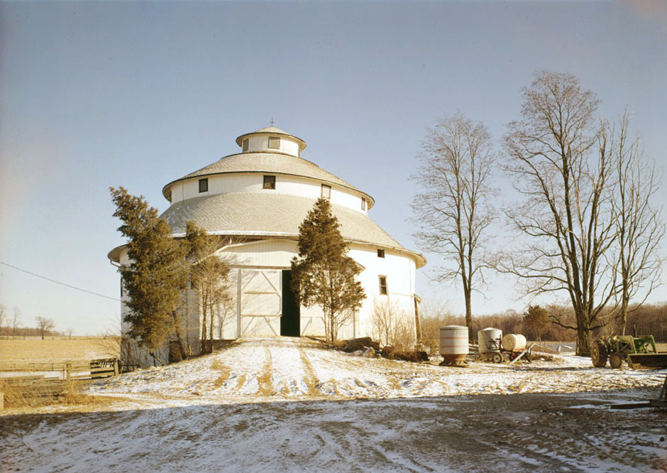
39°43′51″N 85°11′12″W / 39.730833°N 85.186667°WBentonville 5 Thomas Ranck Round Barn 
January 11, 1983 North of Brownsville on County Road 500 N
39°42′50″N 85°02′40″W / 39.713889°N 85.044444°WBrownsville See also
- List of National Historic Landmarks in Indiana
- National Register of Historic Places listings in Indiana
References
- ^ The latitude and longitude information provided in this table was derived originally from the National Register Information System, which has been found to be fairly accurate for about 99% of listings. For about 1% of NRIS original coordinates, experience has shown that one or both coordinates are typos or otherwise extremely far off; some corrections may have been made. A more subtle problem causes many locations to be off by up to 150 yards, depending on location in the country: most NRIS coordinates were derived from tracing out latitude and longitudes off of USGS topographical quadrant maps created under the North American Datum of 1927, which differs from the current, highly accurate WGS84 GPS system used by Google maps. Chicago is about right, but NRIS longitudes in Washington are higher by about 4.5 seconds, and are lower by about 2.0 seconds in Maine. Latitudes differ by about 1.0 second in Florida. Some locations in this table may have been corrected to current GPS standards.
- ^ "National Register of Historic Places: Weekly List Actions". National Park Service, United States Department of the Interior. Retrieved on November 10, 2011.
- ^ Numbers represent an ordering by significant words. Various colorings, defined here, differentiate National Historic Landmark sites and National Register of Historic Places Districts from other NRHP buildings, structures, sites or objects.
- ^ "National Register Information System". National Register of Historic Places. National Park Service. . http://nrhp.focus.nps.gov/natreg/docs/All_Data.html.
U.S. National Register of Historic Places Topics Lists by states Alabama • Alaska • Arizona • Arkansas • California • Colorado • Connecticut • Delaware • Florida • Georgia • Hawaii • Idaho • Illinois • Indiana • Iowa • Kansas • Kentucky • Louisiana • Maine • Maryland • Massachusetts • Michigan • Minnesota • Mississippi • Missouri • Montana • Nebraska • Nevada • New Hampshire • New Jersey • New Mexico • New York • North Carolina • North Dakota • Ohio • Oklahoma • Oregon • Pennsylvania • Rhode Island • South Carolina • South Dakota • Tennessee • Texas • Utah • Vermont • Virginia • Washington • West Virginia • Wisconsin • WyomingLists by territories Lists by associated states Other Municipalities and communities of Fayette County, Indiana City 
Town Townships Unincorporated
communitiesAlpine | Alquina | Bentonville | Bunker Hill | Columbia | Everton | Falmouth | Harrisburg | Huber | Lyonsville | Nulltown | Orange | Springersville | Waterloo
Footnotes ‡This populated place also has portions in an adjacent county or counties
Categories:- Fayette County, Indiana
- National Register of Historic Places in Indiana by county
-


Wikimedia Foundation. 2010.