- National Register of Historic Places listings in Franklin County, Kentucky
-
 Location of Franklin County in Kentucky
This is a list of the National Register of Historic Places listings in Franklin County, Kentucky.
This is intended to be a complete list of the properties and districts on the National Register of Historic Places in Franklin County, Kentucky, United States. The locations of National Register properties and districts for which the latitude and longitude coordinates are included below, may be seen in a Google map.[1]
There are 51 properties and districts listed on the National Register in the county, of which 2 are National Historic Landmarks.
-
- This National Park Service list is complete through NPS recent listings posted November 10, 2011.[2]
Current listings
[3] Landmark name Image Date listed Location City or town Summary 1 Col. R. T. P. Allen House July 10, 1979 South of Frankfort on Johnson Rd.
38°10′14″N 84°51′40″W / 38.170556°N 84.861111°WFrankfort 2 Archeological Site 15 Fr 26 March 31, 1978 Address Restricted Harvieland 3 Archeological Site 15 Fr 34 February 17, 1978 Address Restricted Frankfort 4 Archeological Site 15 Fr 52 February 14, 1978 Address Restricted Harvieland 5 Archeological Site 15 FR 368 September 12, 1985 Address Restricted Frankfort 6 Arrowhead September 28, 1989 U.S. Route 60, 0.5 miles south of Hanley Ln.
38°10′44″N 84°49′10″W / 38.178889°N 84.819444°WFrankfort 7 Beeches February 9, 1979 Off U.S. Route 421
38°12′46″N 84°52′01″W / 38.212778°N 84.866944°WFrankfort 8 George F. Berry House September 6, 2002 700 Louisville Rd.
38°11′15″N 84°52′57″W / 38.1875°N 84.8825°WFrankfort 9 Blanton-Crutcher Farm October 29, 1975 5 miles southeast of Frankfort off U.S. Route 60
38°09′37″N 84°49′13″W / 38.160278°N 84.820278°WFrankfort 10 Central Frankfort Historic District July 28, 2009 Bounded by E. and W. 2nd St., Logan St., the Kentucky River, High St., and Mero St.
38°12′55.18″N 84°52′40.8″W / 38.2153278°N 84.878°WFrankfort 11 Colored Soldiers Monument in Frankfort 
July 17, 1997 Greenhill Cemetery, 0.1 miles southeast of the junction of E. Main St. and Myrtle Ave.
38°12′18″N 84°50′18″W / 38.205°N 84.838333°WFrankfort 12 Confederate Monument in Frankfort 
July 17, 1997 215 E. Main St.
38°11′48″N 84°52′05″W / 38.196667°N 84.868056°WFrankfort 13 Corner in Celebrities Historic District 
March 11, 1971 Roughly bounded by the Kentucky River on the south and the west, St. Clair and Main Sts.
38°11′52″N 84°52′48″W / 38.197778°N 84.88°WFrankfort 14 Dills Site March 21, 1978 Address Restricted Frankfort 15 Frankfort Barracks District November 20, 1975 Bounded by New, Shelby, and Coke Sts., and Woodland Ave.
38°11′19″N 84°52′38″W / 38.188611°N 84.877222°WFrankfort 16 Frankfort Cemetery and Chapel 
July 12, 1974 215 E. Main St.
38°11′38″N 84°51′56″W / 38.193889°N 84.865556°WFrankfort 17 Frankfort Commercial Historic District May 10, 1979 Both sides of the Kentucky River at Bridge St.
38°11′52″N 84°52′35″W / 38.197778°N 84.876389°WFrankfort 18 Frankfort Greenhouses October 9, 1997 210, 212, and 216 E. Main St.
38°11′54″N 84°52′01″W / 38.198333°N 84.866944°WFrankfort 19 Frankfort Storage Building-Armory September 6, 2002 208 Maryland Ave.
38°11′48″N 84°51′31″W / 38.196667°N 84.858611°WFrankfort 20 Giltner-Holt House May 5, 1978 5 miles north of Frankfort
38°15′03″N 84°50′01″W / 38.250833°N 84.833611°WFrankfort 21 Glen Willis June 13, 1972 Leestown Pike
38°12′37″N 84°52′20″W / 38.210278°N 84.872222°WFrankfort 22 Gooch House 
April 30, 1980 104 2nd St.
38°11′42″N 84°52′29″W / 38.195°N 84.874722°WFrankfort 23 Haggin Farm June 23, 1983 KY 1685
38°11′24″N 84°44′25″W / 38.19°N 84.740278°WMidway 24 Andrew Hearn Log House and Farm August 11, 1976 3 miles southwest of Jett on Hanley Lane
38°09′26″N 84°50′08″W / 38.157222°N 84.835556°WJett 25 E.E. Hume Hall May 26, 1983 Kentucky State University campus
38°12′07″N 84°51′21″W / 38.201944°N 84.855833°WFrankfort 26 Hutcherson Site March 21, 1978 Address Restricted Polsgrove 27 Jackson Hall, Kentucky State University April 11, 1973 E. Main St.
38°12′10″N 84°51′29″W / 38.202778°N 84.858056°WFrankfort 28 Julian Farm May 26, 1988 Southern side of U.S. Route 60
38°09′51″N 84°55′49″W / 38.164167°N 84.930278°WBridgeport 29 Kentucky Governor's Mansion 
February 1, 1972 Eastern lawn of the Capitol at the end of Capital Ave.
38°11′14″N 84°52′25″W / 38.187222°N 84.873611°WFrankfort 30 Kentucky State Arsenal April 11, 1973 Main St. at Capital Ave.
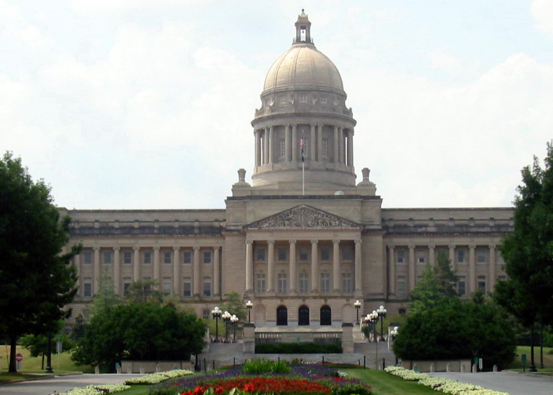
38°11′51″N 84°52′22″W / 38.1975°N 84.872778°WFrankfort 31 Kentucky State Capitol 
April 13, 1973 Capitol grounds at end of Capital Ave.
38°11′12″N 84°52′33″W / 38.186667°N 84.875833°WFrankfort 32 Liberty Hall 
November 11, 1971 218 Wilkinson St.
38°11′56.04″N 84°52′53.148″W / 38.1989°N 84.88143°WFrankfort 33 Gov. Charles S. Morehead House December 30, 1974 217 Shelby St.
38°11′39″N 84°52′47″W / 38.194167°N 84.879722°WFrankfort 34 Old Governor's Mansion March 11, 1971 420 High St.
38°11′58″N 84°52′26″W / 38.199444°N 84.873889°WFrankfort 35 Old Statehouse 
March 11, 1971 On Broadway, bounded by Madison, Clinton, and Lewis Sts.
38°12′01″N 84°52′24″W / 38.200278°N 84.873333°WFrankfort 36 Old Statehouse Historic District June 19, 1980 Roughly bounded by Broadway, Blanton, St. Clair, Ann, and High Sts.
38°12′01″N 84°52′36″W / 38.200278°N 84.876667°WFrankfort 37 Old Stone Tavern June 23, 1983 Scruggs Lane and Leestown Pike
38°11′16″N 84°48′02″W / 38.187778°N 84.800556°WFrankfort 38 Old U.S. Courthouse and Post Office 
July 3, 1974 305 Wapping St.
38°11′51″N 84°52′43″W / 38.1975°N 84.878611°WFrankfort 39 Charles Patterson House June 23, 1983 KY 1689
38°14′00″N 84°46′33″W / 38.233333°N 84.775833°WFrankfort 40 Penn-Marshall Stone House June 5, 1975 East of Harvieland on Stoney Creek Rd. at the Kentucky River
38°15′28″N 84°53′43″W / 38.257778°N 84.895278°WHarvieland 41 Risk Brothers Site November 21, 1978 Address Restricted Frankfort 42 Scotland December 12, 1976 5 miles east of Frankfort on Versailles Rd.
38°10′16″N 84°48′12″W / 38.171111°N 84.803333°WFrankfort 43 South Frankfort Neighborhood Historic District August 19, 1982 Roughly bounded by U.S. Route 60, Rockland Ct., and the Kentucky River
38°11′28″N 84°52′33″W / 38.191111°N 84.875833°WFrankfort 44 George T. Stagg Distillery May 2, 2001 1001 Wilkinson Boulevard
38°12′59″N 84°52′09″W / 38.216389°N 84.869167°WFrankfort 45 Stewart Home School June 3, 1976 5.5 miles south of Frankfort on U.S. Route 127
38°07′35″N 84°54′28″W / 38.126389°N 84.907778°WFrankfort 46 Switzer Covered Bridge September 6, 1974 Off Rocky Branch Rd., over North Elkhorn Creek
38°15′14″N 84°45′08″W / 38.253889°N 84.752222°WSwitzer 47 Robert Todd Summer Home June 23, 1983 U.S. Route 421
38°10′50″N 84°47′13″W / 38.180556°N 84.786944°WFrankfort 48 Andrew Trumbo Log House November 17, 1977 East of Frankfort on Glenns Creek Rd.
38°10′29″N 84°50′53″W / 38.174722°N 84.848056°WFrankfort 49 Valley Farm Ruins July 24, 1975 Address Restricted Frankfort 50 Weehawken April 24, 2007 1 Weehawken Ln.
38°11′44″N 84°49′20″W / 38.195556°N 84.822222°WJett 51 Rev. Jesse R. Zeigler House 
May 3, 1976 509 Shelby St.
38°11′25″N 84°52′35″W / 38.190278°N 84.876389°WFrankfort See also
- List of National Historic Landmarks in Kentucky
- National Register of Historic Places listings in Kentucky
References
- ^ The latitude and longitude information provided in this table was derived originally from the National Register Information System, which has been found to be fairly accurate for about 99% of listings. For about 1% of NRIS original coordinates, experience has shown that one or both coordinates are typos or otherwise extremely far off; some corrections may have been made. A more subtle problem causes many locations to be off by up to 150 yards, depending on location in the country: most NRIS coordinates were derived from tracing out latitude and longitudes off of USGS topographical quadrant maps created under the North American Datum of 1927, which differs from the current, highly accurate WGS84 GPS system used by Google maps. Chicago is about right, but NRIS longitudes in Washington are higher by about 4.5 seconds, and are lower by about 2.0 seconds in Maine. Latitudes differ by about 1.0 second in Florida. Some locations in this table may have been corrected to current GPS standards.
- ^ "National Register of Historic Places: Weekly List Actions". National Park Service, United States Department of the Interior. Retrieved on November 10, 2011.
- ^ Numbers represent an ordering by significant words. Various colorings, defined here, differentiate National Historic Landmark sites and National Register of Historic Places Districts from other NRHP buildings, structures, sites or objects.
U.S. National Register of Historic Places Topics Lists by states Alabama • Alaska • Arizona • Arkansas • California • Colorado • Connecticut • Delaware • Florida • Georgia • Hawaii • Idaho • Illinois • Indiana • Iowa • Kansas • Kentucky • Louisiana • Maine • Maryland • Massachusetts • Michigan • Minnesota • Mississippi • Missouri • Montana • Nebraska • Nevada • New Hampshire • New Jersey • New Mexico • New York • North Carolina • North Dakota • Ohio • Oklahoma • Oregon • Pennsylvania • Rhode Island • South Carolina • South Dakota • Tennessee • Texas • Utah • Vermont • Virginia • Washington • West Virginia • Wisconsin • WyomingLists by territories Lists by associated states Other Municipalities and communities of Franklin County, Kentucky City 
Unincorporated
communityCategories:- National Register of Historic Places in Kentucky by county
- Franklin County, Kentucky
-


Wikimedia Foundation. 2010.