- National Register of Historic Places listings in Fulton County, Kentucky
-
 Location of Fulton County in Kentucky
This is a list of the National Register of Historic Places listings in Fulton County, Kentucky. It is intended to be a complete list of the properties and districts on the National Register of Historic Places in Fulton County, Kentucky, United States. The locations of National Register properties and districts for which the latitude and longitude coordinates are included below, may be seen in a Google map.[1]
There are 16 properties and districts listed on the National Register in the county.
-
- This National Park Service list is complete through NPS recent listings posted November 10, 2011.[2]
Listings county-wide
[3] Landmark name Image Date listed Location City or town Summary 1 Adams Site (15FU4) March 15, 1984 Address Restricted Hickman 2 Amburg Mounds Site (15FU15) December 31, 1985 Address Restricted Hickman 3 Buchanan Street Historic District August 3, 1990 Roughly bounded by Wellington, Obion, Buchanan, and Union Sts.
36°34′13″N 89°11′46″W / 36.570278°N 89.196111°WHickman 4 Carnegie Library August 3, 1990 Moscow Ave. between Troy Ave. and 3rd St.
36°34′17″N 89°11′09″W / 36.571389°N 89.185833°WHickman 5 Carr Historic District May 2, 2001 Roughly bounded by Carr, 4th, W. State Line and West Sts.
36°30′18″N 88°52′52″W / 36.505°N 88.881111°WFulton 6 Ben F. Carr, Jr. House July 16, 1979 203 2nd St.
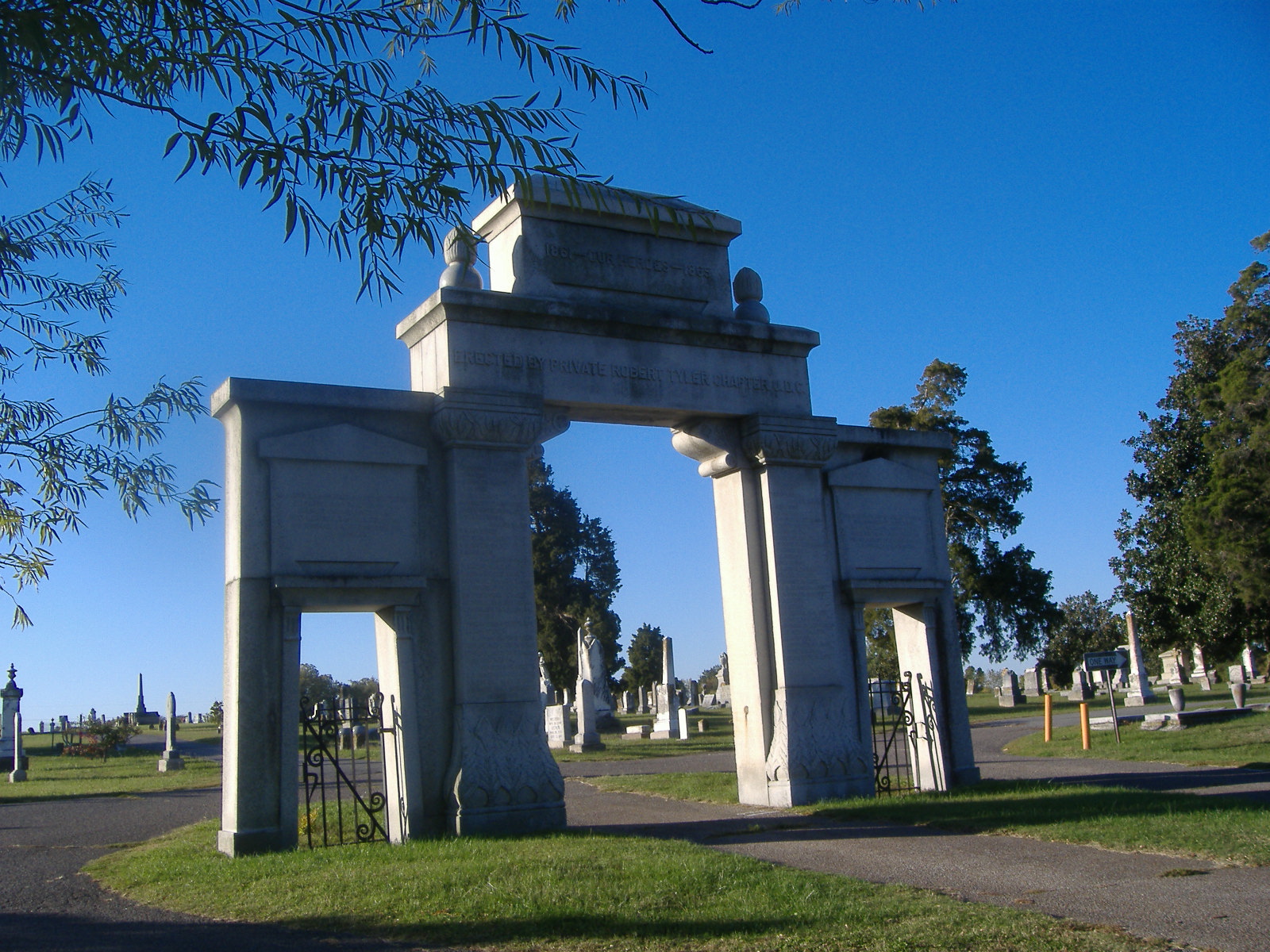
36°30′14″N 88°52′48″W / 36.503889°N 88.88°WFulton 7 Confederate Memorial Gateway in Hickman 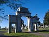
July 17, 1997 Hickman City Cemetery, 0.5 miles south of the junction of KY 125 and KY 199
36°33′30″N 89°10′40″W / 36.558333°N 89.177778°WHickman 8 Confederate Memorial in Fulton 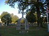
July 17, 1997 Fairview Cemetery, 2 blocks north of the junction of College and 5th Sts
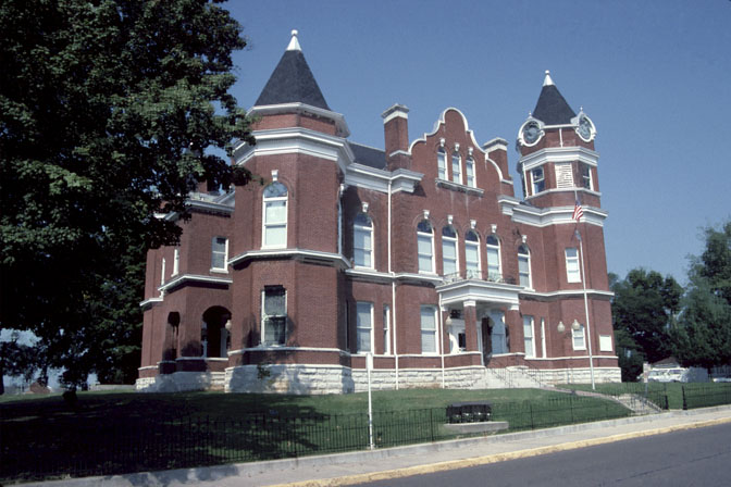
36°30′44″N 88°52′51″W / 36.512222°N 88.880833°WFulton 9 Fulton County Courthouse 
April 22, 1976 Off KY 94
36°34′18″N 89°11′38″W / 36.571667°N 89.193889°WHickman 10 Fulton Downtown Historic District August 1, 2003 Park of Carr, Commercial, Lake, Main and Walnut Sts.
36°30′12″N 88°52′30″W / 36.503333°N 88.875°WFulton 11 Old Hickman Historic District August 3, 1990 Roughly bounded by Clinton, Exchange, Obion, Moulton, and Kentucky Sts.
36°34′20″N 89°11′42″W / 36.572222°N 89.195°WHickman 12 Running Slough Site (15FU67) December 5, 1985 Address Restricted Hickman 13 Sassafras Ridge (Site 15FU3) November 23, 1984 Address Restricted Hickman 14 Thomas Chapel C.M.E. Church January 9, 1979 Moscow Ave.
36°34′17″N 89°11′21″W / 36.571389°N 89.189167°WHickman 15 White Site (15FU24) March 21, 1988 Address Restricted Moscow 16 Jesse Whitesell House August 29, 1977 West of Fulton on KY 116; also KY 116 west of the Purchase Parkway
36°30′10″N 88°54′06″W / 36.502778°N 88.901667°WFulton Second set of addresses represents a boundary increase, listed on February 4, 2009. This increase included an expansion, the Jesse Whitesell Farm, into Obion County, Tennessee. See also
- List of National Historic Landmarks in Kentucky
- National Register of Historic Places listings in Kentucky
References
- ^ The latitude and longitude information provided in this table was derived originally from the National Register Information System, which has been found to be fairly accurate for about 99% of listings. For about 1% of NRIS original coordinates, experience has shown that one or both coordinates are typos or otherwise extremely far off; some corrections may have been made. A more subtle problem causes many locations to be off by up to 150 yards, depending on location in the country: most NRIS coordinates were derived from tracing out latitude and longitudes off of USGS topographical quadrant maps created under North American Datum of 1927, which differs from the current, highly accurate GPS system used by Google maps. Chicago is about right, but NRIS longitudes in Washington are higher by about 4.5 seconds, and are lower by about 2.0 seconds in Maine. Latitudes differ by about 1.0 second in Florida. Some locations in this table may have been corrected to current GPS standards.
- ^ "National Register of Historic Places: Weekly List Actions". National Park Service, United States Department of the Interior. Retrieved on November 10, 2011.
- ^ Numbers represent an ordering by significant words. Various colorings, defined here, differentiate National Historic Landmark sites and National Register of Historic Places Districts from other NRHP buildings, structures, sites or objects.
U.S. National Register of Historic Places Topics Lists by states Alabama • Alaska • Arizona • Arkansas • California • Colorado • Connecticut • Delaware • Florida • Georgia • Hawaii • Idaho • Illinois • Indiana • Iowa • Kansas • Kentucky • Louisiana • Maine • Maryland • Massachusetts • Michigan • Minnesota • Mississippi • Missouri • Montana • Nebraska • Nevada • New Hampshire • New Jersey • New Mexico • New York • North Carolina • North Dakota • Ohio • Oklahoma • Oregon • Pennsylvania • Rhode Island • South Carolina • South Dakota • Tennessee • Texas • Utah • Vermont • Virginia • Washington • West Virginia • Wisconsin • WyomingLists by territories Lists by associated states Other  Category:National Register of Historic Places •
  Portal:National Register of Historic Places
Municipalities and communities of Fulton County, Kentucky County seat: Hickman Cities 
Ghost town Categories:- National Register of Historic Places in Kentucky by county
- Fulton County, Kentucky
-


Wikimedia Foundation. 2010.