- National Register of Historic Places listings in Gila County, Arizona
-
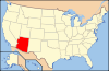
 Location of Gila County in Arizona
This is a list of the National Register of Historic Places listings in Gila County, Arizona.
This is intended to be a complete list of the properties and districts on the National Register of Historic Places in Gila County, Arizona, United States. The locations of National Register properties and districts for which the latitude and longitude coordinates are included below, may be seen in a Google map.[1]
There are 51 properties and districts listed on the National Register in the county, including 1 that is also a National Historic Landmark.
-
- This National Park Service list is complete through NPS recent listings posted November 10, 2011.[2]
Current listings
[3] Landmark name Image Date listed Location City or town Summary 1 Archeological Site No. AR-03-12-06-1130(TNF) April 21, 1989 Address Restricted Punkin Center 2 Archeological Site No. AR-03-12-06-1131(TNF) April 21, 1989 Address Restricted Punkin Center 3 Besh-Ba-Gowah May 9, 1984 South of Globe
33°22′55″N 110°46′19″W / 33.381944°N 110.771944°WGlobe 4 Black River Bridge September 30, 1988 Indian Route 9 the over Black River
33°42′46″N 110°12′40″W / 33.712778°N 110.211111°WCarrizo 5 Bullion Plaza School January 4, 2001 1000 Plaza Ave.
33°23′44″N 110°52′45″W / 33.395556°N 110.879167°WMiami 6 Cline Terrace Platform Mound (AR-03-12-06-132 TNF) April 21, 1989 Address Restricted Punkin Center 7 Coolidge Dam 
October 29, 1981 Southwest of San Carlos
33°10′26″N 110°31′37″W / 33.173889°N 110.526944°WSan Carlos 8 Cordova Avenue Bridge March 31, 1989 Cordova Ave. over Bloody Tanks Wash
33°23′44″N 110°52′32″W / 33.395556°N 110.875556°WMiami 9 Diamond Point Lookout Cabin January 28, 1988 Tonto National Forest
34°17′15″N 111°11′32″W / 34.2875°N 111.192222°WTonto Village 10 Dominion Hotel May 22, 1978 S. Broad St.
33°23′42″N 110°47′11″W / 33.395°N 110.786389°WGlobe 11 Elks Building August 6, 1987 155 W. Mesquite
33°23′47″N 110°46′36″W / 33.396389°N 110.776667°WGlobe 12 Fossil Creek Bridge September 30, 1988 Forest Service Rd. over Fossil Creek
34°23′39″N 111°37′45″W / 34.394167°N 111.629167°WStrawberry 13 Gila County Courthouse 
May 27, 1975 Oak and Broad Sts.
33°23′46″N 110°47′11″W / 33.396111°N 110.786389°WGlobe 14 Gila Pueblo November 17, 1977 South of Globe
33°21′53″N 110°46′01″W / 33.364722°N 110.766944°WGlobe 15 Gila Valley Bank and Trust Building August 6, 1987 292 N. Broad St.
33°23′47″N 110°46′34″W / 33.396389°N 110.776111°WGlobe 16 Globe Downtown Historic District 
May 28, 1987 Broad St. between Cedar and Tebbs
33°23′41″N 110°47′07″W / 33.394722°N 110.785278°WGlobe 17 Globe Mine Rescue Station June 7, 1990 1330 N. Broad St.
33°24′34″N 110°47′40″W / 33.409444°N 110.794444°WGlobe 18 Holy Angels Church 
December 1, 1983 231 S. Broad St.
33°23′41″N 110°47′08″W / 33.394722°N 110.785556°WGlobe 19 Houston Mesa Ruins September 4, 1986 Address Restricted Payson 20 Inspiration Avenue Bridge March 31, 1989 Inspiration Ave. over Bloody Tanks Wash
33°23′46″N 110°52′29″W / 33.396111°N 110.874722°WMiami 21 International House March 31, 1988 636-638 N. Broad St.
33°24′00″N 110°47′20″W / 33.4°N 110.788889°WGlobe 22 Keystone Avenue Bridge March 31, 1989 Keystone Ave. over Bloody Tanks Wash
33°23′48″N 110°52′27″W / 33.396667°N 110.874167°WMiami 23 Kinishba Ruins 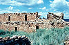
October 15, 1966 Address Restricted Whiteriver Pueblo ruins, designated a National Historic Landmark 24 La Santa Cruz de Globe April 22, 2011 Hilltop in Ruiz Canyon, east of Navarro Dr. and west of Side Canyon Globe 25 Miami Avenue Bridge March 31, 1989 Miami Ave. over Bloody Tanks Wash
33°23′17″N 110°52′25″W / 33.388056°N 110.873611°WMiami 26 Miami Community Church March 15, 2005 305 Live Oak
33°23′58″N 110°52′03″W / 33.399444°N 110.8675°WMiami 27 Pryor Miller House March 10, 2004 3800 State Route 87
34°23′08″N 111°27′16″W / 34.385556°N 111.454444°WPine 28 Natural Bridge Lodge August 21, 1986 Off State Route 87
34°19′20″N 111°27′11″W / 34.322222°N 111.453056°WPayson 29 Oak Creek Platform Mound (AR-03-12-06-714 TNF) April 21, 1989 Address Restricted Punkin Center 30 Our Lady of the Blessed Sacrament Church January 2, 2008 914 Sullivan St.
33°23′53″N 110°52′26″W / 33.398056°N 110.873889°WMiami 31 Ox Bow Inn October 1, 2004 607 W. Main St.
34°13′51″N 111°20′10″W / 34.230833°N 111.336111°WPayson Rustic inn with design elements copied from Yellowstone's Old Faithful Inn 32 Park Creek Platform Mound (AR-03-12-06-1044 TNF) April 21, 1989 Address Restricted Punkin Center 33 Perkins Store February 5, 1999 State Route 288, 1.5 miles southwest of Young
34°05′46″N 110°57′38″W / 34.096111°N 110.960556°WYoung 34 Pinal Ranger Station June 10, 1993 South of Globe in the Tonto National Forest
33°22′40″N 110°46′13″W / 33.377778°N 110.770278°WGlobe 35 Pine Community Center Historic District February 24, 2005 Bounded by Randall Dr., State Routes 87/260, unnamed service road, and Pine Creek Dr.
34°23′16″N 111°27′16″W / 34.387778°N 111.454444°WPine 36 Pleasant Valley Ranger Station June 10, 1993 South of State Route 288 in the Tonto National Forest
34°06′53″N 110°56′27″W / 34.114722°N 110.940833°WYoung 37 Alfred Jason Randall House September 29, 2000 State Route 87
34°23′11″N 111°27′15″W / 34.386389°N 111.454167°WPine 38 Reppy Avenue Bridge September 30, 1988 Reppy Ave. over Bloody Tanks Wash
33°23′42″N 110°52′34″W / 33.395°N 110.876111°WMiami 39 Rye Creek Ruin Platform Mound Complex Archeological District November 24, 1995 Address Restricted Rye 40 St. John's Episcopal Church November 22, 1977 175 E. Oak St.
33°23′47″N 110°47′08″W / 33.396389°N 110.785556°WGlobe 41 Salt River Bridge September 30, 1988 State Route 288 over the Salt River at milepost 262.4
33°37′09″N 110°55′15″W / 33.619167°N 110.920833°WRoosevelt 42 Salt River Canyon Bridge 
September 30, 1988 U.S. Route 60 over the Salt River at milepost 292.9
33°47′19″N 110°30′50″W / 33.788611°N 110.513889°WCarrizo 43 Schoolhouse Point (AR-03-12-06-13 TNF) April 21, 1989 Address Restricted Roosevelt 44 Soderman Building May 11, 2000 55 Chisholm
33°23′56″N 110°52′18″W / 33.398889°N 110.871667°WMiami 45 Strawberry School May 10, 2005 9318 Fossil Creek Rd., approximately 1.5 miles west of State Routes 87/260
34°24′23″N 111°31′08″W / 34.406389°N 111.518889°WStrawberry 46 Theodore Roosevelt Dam National Register District 
March 16, 1998 Linear area along the shore of Lake Roosevelt from the dam to the canal intake
33°39′19″N 111°04′54″W / 33.655278°N 111.081667°WRoosevelt District includes resources that were involved in the construction of the dam, but the dam itself is not a contributing property[4] 47 Tonto National Monument Archeological District October 15, 1966 Address Restricted Roosevelt 48 Tonto National Monument Visitor Center September 9, 2010 Arizona State Highway 188 Gila vicinity 49 Tonto National Monument, Lower Ruin (AZ U:8:047A ASM) 
April 21, 1989 Off State Route 188
33°38′40″N 111°06′56″W / 33.644444°N 111.115556°WRoosevelt 50 Tonto National Monument, Upper Ruin (AZ U:8:048 ASM) April 21, 1989 Off State Route 188
33°38′27″N 111°06′56″W / 33.640833°N 111.115556°WRoosevelt 51 US Post Office and Courthouse-Globe Main 
December 3, 1985 Hill and Sycamore Sts.
33°23′13″N 110°47′06″W / 33.386944°N 110.785°WGlobe See also
- List of National Historic Landmarks in Arizona
- National Register of Historic Places listings in Arizona
References
- ^ The latitude and longitude information provided in this table was derived originally from the National Register Information System, which has been found to be fairly accurate for about 99% of listings. For about 1% of NRIS original coordinates, experience has shown that one or both coordinates are typos or otherwise extremely far off; some corrections may have been made. A more subtle problem causes many locations to be off by up to 150 yards, depending on location in the country: most NRIS coordinates were derived from tracing out latitude and longitudes off of USGS topographical quadrant maps created under the North American Datum of 1927, which differs from the current, highly accurate WGS84 GPS system used by Google maps. Chicago is about right, but NRIS longitudes in Washington are higher by about 4.5 seconds, and are lower by about 2.0 seconds in Maine. Latitudes differ by about 1.0 second in Florida. Some locations in this table may have been corrected to current GPS standards.
- ^ "National Register of Historic Places: Weekly List Actions". National Park Service, United States Department of the Interior. Retrieved on November 10, 2011.
- ^ Numbers represent an ordering by significant words. Various colorings, defined here, differentiate National Historic Landmark sites and National Register of Historic Places Districts from other NRHP buildings, structures, sites or objects.
- ^ "Withdrawal of National Historic Landmark Designation: Roosevelt Dam, Gila and Maricopa Counties, Arizona". http://www.nps.gov/history/nhl/DOE_dedesignations/Roosevelt.htm. Retrieved 2010-03-05.
U.S. National Register of Historic Places Topics Lists by states Alabama • Alaska • Arizona • Arkansas • California • Colorado • Connecticut • Delaware • Florida • Georgia • Hawaii • Idaho • Illinois • Indiana • Iowa • Kansas • Kentucky • Louisiana • Maine • Maryland • Massachusetts • Michigan • Minnesota • Mississippi • Missouri • Montana • Nebraska • Nevada • New Hampshire • New Jersey • New Mexico • New York • North Carolina • North Dakota • Ohio • Oklahoma • Oregon • Pennsylvania • Rhode Island • South Carolina • South Dakota • Tennessee • Texas • Utah • Vermont • Virginia • Washington • West Virginia • Wisconsin • WyomingLists by territories Lists by associated states Other Properties on the National Register of Historic Places in Arizona 
Municipalities and communities of Gila County, Arizona City 
Towns Hayden‡ | Miami | Payson | Star Valley | Winkelman‡
CDPs Canyon Day | Central Heights-Midland City | Claypool | Gisela | Peridot‡ | Pine | San Carlos | Strawberry | Tonto Basin | Top-of-the-World‡ | Young
Unincorporated
communitiesKohls Ranch | Punkin Center | Roosevelt | Rye
Indian reservations Ghost towns Bellevue | McMillenville
Footnotes ‡This populated place also has portions in an adjacent county or counties
Categories:- National Register of Historic Places in Arizona by county
- History of Gila County, Arizona
-


Wikimedia Foundation. 2010.