- National Register of Historic Places listings in Graves County, Kentucky
-
 Location of Graves County in Kentucky
This is a list of the National Register of Historic Places listings in Graves County, Kentucky.
It is intended to be a complete list of the properties and districts on the National Register of Historic Places in Graves County, Kentucky, United States. The locations of National Register properties and districts for which the latitude and longitude coordinates are included below, may be seen in a Google map.[1]
There are 10 properties and districts listed on the National Register in the county.
-
- This National Park Service list is complete through NPS recent listings posted November 10, 2011.[2]
Current listings
[3] Landmark name Image Date listed Location City or town Summary 1 Camp Beauregard Memorial in Water Valley 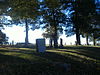
July 17, 1997 Camp Beauregard Cemetery, 0.5 miles south of the junction of Roy Lawrence and Cuba Rds.
36°34′22″N 88°47′36″W / 36.572778°N 88.793333°WWater Valley 2 Confederate Memorial Gates in Mayfield 
July 17, 1997 Maplewood Cemetery, 1 block south of the junction of Kentucky Routes 80 and 121
36°45′02″N 88°38′08″W / 36.750556°N 88.635556°WMayfield 3 Confederate Memorial in Mayfield 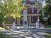
July 17, 1997 2 blocks north of the junction of 5th and Lee Sts.
36°44′33″N 88°38′07″W / 36.7425°N 88.635278°WMayfield 4 Pete Lyles House December 26, 2006 302 Kentucky Route 348, E.
36°55′07″N 88°30′54″W / 36.918611°N 88.515°WSymsonia 5 Mayfield Downtown Commercial District 
August 16, 1984 Roughly bounded by North, Water, 5th, and 9th Sts.; also roughly bounded by N. 9th, W. and E. North, N. and S. 5th, E. Water, and S. and N. 8th Sts.
36°44′28″N 88°38′09″W / 36.741111°N 88.635833°WMayfield Second set of streets represents a boundary increase 6 Mayfield Electric and Water Systems August 18, 2011 301 E. Broadway
36°44′30″N 88°38′00″W / 36.741667°N 88.633333°WMayfield 7 Meacham Manor December 31, 1974 7 miles east of Fulton off Kentucky Route 116
36°30′20″N 88°43′33″W / 36.505556°N 88.725833°WFulton 8 U.S. Post Office December 2, 1982 9th St. and Broadway
36°44′29″N 88°38′18″W / 36.741389°N 88.638333°WMayfield 9 Wooldridge Monuments 
August 11, 1980 Maplewood Cemetery
36°44′59″N 88°38′09″W / 36.749722°N 88.635833°WMayfield 10 Youngblood Site (15GV26) April 4, 1986 Address Restricted Hicksville See also
- List of National Historic Landmarks in Kentucky
- National Register of Historic Places listings in Kentucky
References
- ^ The latitude and longitude information provided in this table was derived originally from the National Register Information System, which has been found to be fairly accurate for about 99% of listings. For about 1% of NRIS original coordinates, experience has shown that one or both coordinates are typos or otherwise extremely far off; some corrections may have been made. A more subtle problem causes many locations to be off by up to 150 yards, depending on location in the country: most NRIS coordinates were derived from tracing out latitude and longitudes off of USGS topographical quadrant maps created under the North American Datum of 1927, which differs from the current, highly accurate WGS84 GPS system used by Google maps. Chicago is about right, but NRIS longitudes in Washington are higher by about 4.5 seconds, and are lower by about 2.0 seconds in Maine. Latitudes differ by about 1.0 second in Florida. Some locations in this table may have been corrected to current GPS standards.
- ^ "National Register of Historic Places: Weekly List Actions". National Park Service, United States Department of the Interior. Retrieved on November 10, 2011.
- ^ Numbers represent an ordering by significant words. Various colorings, defined here, differentiate National Historic Landmark sites and National Register of Historic Places Districts from other NRHP buildings, structures, sites or objects.
U.S. National Register of Historic Places Topics Lists by states Alabama • Alaska • Arizona • Arkansas • California • Colorado • Connecticut • Delaware • Florida • Georgia • Hawaii • Idaho • Illinois • Indiana • Iowa • Kansas • Kentucky • Louisiana • Maine • Maryland • Massachusetts • Michigan • Minnesota • Mississippi • Missouri • Montana • Nebraska • Nevada • New Hampshire • New Jersey • New Mexico • New York • North Carolina • North Dakota • Ohio • Oklahoma • Oregon • Pennsylvania • Rhode Island • South Carolina • South Dakota • Tennessee • Texas • Utah • Vermont • Virginia • Washington • West Virginia • Wisconsin • WyomingLists by territories Lists by associated states Other Municipalities and communities of Graves County, Kentucky Cities 
CDPs Fancy Farm | Farmington | Hickory | Lowes | Pryorsburg | Sedalia | Symsonia
Unincorporated
communitiesFootnotes ‡This populated place also has portions in an adjacent county or counties
Categories:- National Register of Historic Places in Kentucky by county
- Graves County, Kentucky
-


Wikimedia Foundation. 2010.