- National Register of Historic Places listings in Highland County, Ohio
-
 Location of Highland County in Ohio
This is a list of the National Register of Historic Places listings in Highland County, Ohio.
This is intended to be a complete list of the properties and districts on the National Register of Historic Places in Highland County, Ohio, United States. The locations of National Register properties and districts for which the latitude and longitude coordinates are included below, may be seen in a Google map.[1]
There are 26 properties and districts listed on the National Register in the county. Another property was once listed but has been removed.
-
- This National Park Service list is complete through NPS recent listings posted November 10, 2011.[2]
Current listings
[3] Landmark name [4] Image Date listed Location City or town Summary 1 Barretts Mills December 26, 1972 County Road 1A and Rocky Fork Creek, southeast of Rainsboro; also on Factory Branch Creek
39°12′07″N 83°23′14″W / 39.201944°N 83.387222°WPaint Township Factory Branch Creek represents a boundary increase of July 24, 1979 2 Bell Mansion November 25, 1980 225 Oak St.
39°12′08″N 83°36′59″W / 39.202222°N 83.616389°WHillsboro 3 Bell's First Home November 25, 1980 222 Beech St.
39°12′08″N 83°36′59″W / 39.202222°N 83.616389°WHillsboro 4 Bell's Opera House November 25, 1980 109-119 S. High St.
39°12′08″N 83°36′59″W / 39.202222°N 83.616389°WHillsboro 5 C. S. Bell Foundry and Showroom November 25, 1980 154-158 W. Main St.
39°12′08″N 83°36′59″W / 39.202222°N 83.616389°WHillsboro 6 East Main Street Historic District June 1, 1982 E. Main and E. Walnut Sts.
39°12′04″N 83°36′30″W / 39.201111°N 83.608333°WHillsboro 7 Eubanks-Tytus House February 27, 1979 Southeast of Hillsboro on State Route 41
39°08′55″N 83°21′59″W / 39.148611°N 83.366389°WBrush Township 8 Fort Hill State Park November 10, 1970 Southeast of Hillsboro on State Route 41
39°06′38″N 83°24′10″W / 39.110556°N 83.402778°WBrush Township 9 Highland County Courthouse 
August 24, 1978 Main and High Sts.
39°12′09″N 83°36′43″W / 39.2025°N 83.611944°WHillsboro 10 Highland Egg and Poultry Company Building January 24, 2002 135 N. West St.
39°12′13″N 83°36′50″W / 39.203611°N 83.613889°WHillsboro 11 Hillsboro Historic Business District April 19, 1984 Roughly bounded by Beech, Walnut, East, and West Sts.
39°12′08″N 83°36′44″W / 39.202222°N 83.612222°WHillsboro 12 Hirons-Brown House December 12, 1976 Southwest of Buford on Guernsey Rd.
39°03′50″N 83°51′52″W / 39.063889°N 83.864444°WClay Township 13 Robert D. Lilley House June 17, 1982 7915 State Route 124, east of Hillsboro
39°11′53″N 83°35′42″W / 39.198056°N 83.595°WLiberty Township 14 Samuel Lyle Log House July 28, 1995 7190 Pondlick Rd., northwest of Seaman
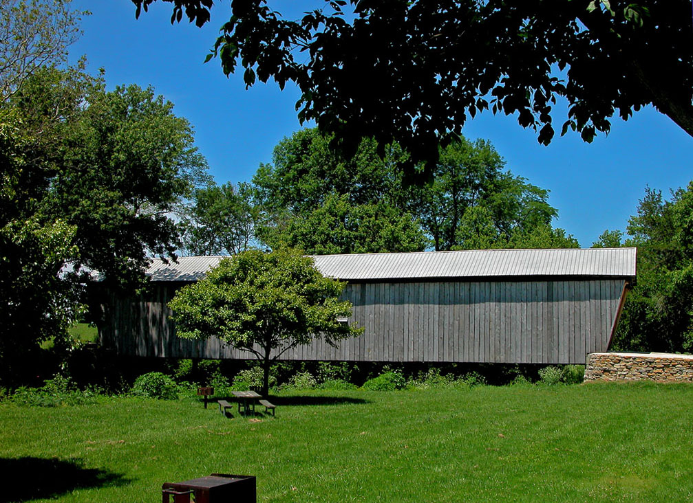
39°02′28″N 83°37′41″W / 39.041111°N 83.628056°WConcord Township 15 Lynchburg Covered Bridge 
March 16, 1976 East Fork of the Little Miami River
39°14′42″N 83°47′40″W / 39.245°N 83.794444°WLynchburg Extends into Clinton County 16 Morrow-Overman-Fairley House May 31, 1984 404 N. High St.
39°12′22″N 83°36′37″W / 39.206111°N 83.610278°WHillsboro 17 Mother Thompson House June 1, 1982 133 Willow St.
39°12′18″N 83°36′35″W / 39.205°N 83.609722°WHillsboro 18 New Market Township Community House March 10, 2004 4641 U.S. Route 62, southwest of Hillsboro
39°08′15″N 83°40′06″W / 39.1375°N 83.668333°WNew Market Township 19 Rocky Fork Park Group June 18, 1973 Address Restricted Marshall Township Near Marshall 20 Rocky Fork Park Site June 18, 1973 Address Restricted Paint Township Near Rainsboro 21 Saint Mary's Episcopal Church and Parish House September 8, 1988 232 N. High St.
39°12′16″N 83°36′38″W / 39.204444°N 83.610556°WHillsboro 22 William Scott House November 5, 1987 338 W. Main St.
39°12′45″N 83°37′06″W / 39.2125°N 83.618333°WHillsboro 23 Samuel Smith House and Tannery 
July 5, 1978 103 Jefferson St.
39°21′09″N 83°22′45″W / 39.3525°N 83.379167°WGreenfield 24 Travellers' Rest Inn 
May 15, 1979 Jefferson St. and McArthur Way
39°21′07″N 83°22′43″W / 39.351944°N 83.378611°WGreenfield 25 Trop Farm April 1, 1982 6250 Mad River Rd., west of Hillsboro
39°10′53″N 83°40′32″W / 39.181389°N 83.675556°WNew Market Township 26 Workman Works October 26, 1971 4206 Certier Rd.
39°7′27″N 83°48′52″W / 39.12417°N 83.81444°W[5]Salem Township Former listing
[3] Landmark name Image Date listed Location City or town Summary 1 Plum Run Mound January 1, 1974 Address Restricted Rainsboro See also
References
- ^ The latitude and longitude information provided in this table was derived originally from the National Register Information System, which has been found to be fairly accurate for about 99% of listings. For about 1% of NRIS original coordinates, experience has shown that one or both coordinates are typos or otherwise extremely far off; some corrections may have been made. A more subtle problem causes many locations to be off by up to 150 yards, depending on location in the country: most NRIS coordinates were derived from tracing out latitude and longitudes off of USGS topographical quadrant maps created under the North American Datum of 1927, which differs from the current, highly accurate WGS84 GPS system used by Google maps. Chicago is about right, but NRIS longitudes in Washington are higher by about 4.5 seconds, and are lower by about 2.0 seconds in Maine. Latitudes differ by about 1.0 second in Florida. Some locations in this table may have been corrected to current GPS standards.
- ^ "National Register of Historic Places: Weekly List Actions". National Park Service, United States Department of the Interior. Retrieved on November 10, 2011.
- ^ a b Numbers represent an ordering by significant words. Various colorings, defined here, differentiate National Historic Landmark sites and National Register of Historic Places Districts from other NRHP buildings, structures, sites or objects.
- ^ "National Register Information System". National Register of Historic Places. National Park Service. . http://nrhp.focus.nps.gov/natreg/docs/All_Data.html.
- ^ Location derived from property owner's website; the NRIS lists the site as "Address Restricted"
National Register of Historic Places in Ohio Lists by county Adams • Allen • Ashland • Ashtabula • Athens • Auglaize • Belmont • Brown • Butler • Carroll • Champaign • Clark • Clermont • Clinton • Columbiana • Coshocton • Crawford • Cuyahoga • Darke • Defiance • Delaware • Erie • Fairfield • Fayette • Franklin • Fulton • Gallia • Geauga • Greene • Guernsey • Hamilton • Hancock • Hardin • Harrison • Henry • Highland • Hocking • Holmes • Huron • Jackson • Jefferson • Knox • Lake • Lawrence • Licking • Logan • Lorain • Lucas • Madison • Mahoning • Marion • Medina • Meigs • Mercer • Miami • Monroe • Montgomery • Morgan • Morrow • Muskingum • Noble • Ottawa • Paulding • Perry • Pickaway • Pike • Portage • Preble • Putnam • Richland • Ross • Sandusky • Scioto • Seneca • Shelby • Stark • Summit • Trumbull • Tuscarawas • Union • Van Wert • Vinton • Warren • Washington • Wayne • Williams • Wood • Wyandot
Lists by city Other lists Municipalities and communities of Highland County, Ohio City 
Villages Greenfield‡ | Highland | Lynchburg‡ | Leesburg | Mowrystown | Sardinia‡ | Sinking Spring
Townships Unincorporated
communitiesFootnotes ‡This populated place also has portions in an adjacent county or counties
Categories:- National Register of Historic Places in Ohio by county
- Highland County, Ohio
-


Wikimedia Foundation. 2010.