- National Register of Historic Places listings in Hinds County, Mississippi
-
 Location of Hinds County in Mississippi
This is a list of the National Register of Historic Places listings in Hinds County, Mississippi.
This is intended to be a complete list of the properties and districts on the National Register of Historic Places in Hinds County, Mississippi, United States. Latitude and longitude coordinates are provided for many National Register properties and districts; these locations may be seen together in a Google map.[1]
There are 93 properties and districts listed on the National Register in the county, including 3 National Historic Landmarks. Another property was once listed but has been removed.
-
- This National Park Service list is complete through NPS recent listings posted November 10, 2011.[2]
Current listings
[3] Landmark name[4] Image Date listed Location City or Town Summary 1 Ayer Hall July 14, 1977 1400 Lynch St. on the Jackson State University campus
32°17′45″N 90°12′27″W / 32.29583°N 90.2075°WJackson 2 Bailey Hill Civil War Earthworks May 6, 1975 Off U.S. Route 51
32°16′27″N 90°11′57″W / 32.27417°N 90.19917°WJackson 3 Baldwin's Ferry Mound September 24, 1998 Address Restricted Newman 4 Bardin Mound (22-Hi-537) March 1, 1987 Address Restricted Coxs Ferry 5 Belhaven Heights Historic District November 25, 1983 Bellevue Place, N. Jefferson, Madison, and Morningside Sts.; also roughly bounded by Fortification, North, Monroe, and Spenglar Sts.
32°18′33″N 90°10′28″W / 32.30917°N 90.17444°WJackson Second set of boundaries represents a boundary increase of September 3, 1998 6 Bellevue Court Apartments November 21, 1994 950 North St.
32°18′39″N 90°10′33″W / 32.31083°N 90.17583°WJackson 7 Berry Mound and Village Archeological Site November 25, 1969 Address Restricted Terry 8 Big Black River Battlefield November 23, 1971 On both banks of the Big Black River between Smith's Station and Bovina
32°21′36″N 90°43′35″W / 32.36°N 90.72639°WSmith's Station Site of the Battle of Big Black River Bridge; extends into Warren County 9 Big Black River Railroad Bridge 
November 16, 1988 Spans the Big Black River east of Bovina
32°20′49″N 90°42′17″W / 32.34694°N 90.70472°WEdwards Extends into Warren County 10 Lillian Boteler House July 15, 1986 214 Port Gibson Rd.
32°15′28″N 90°25′27″W / 32.25778°N 90.42417°WRaymond 11 Byram Bridge May 23, 1979 Old Byram and Florence Rd.
32°10′35″N 90°14′37″W / 32.17639°N 90.24361°WByram Extends into Rankin County 12 Capitol Green November 25, 1969 Bounded on the north by Amite St., on the south by Pearl St., on the west by State St., and on the east by the Gulf, Mobile and Ohio railroad line
32°17′56″N 90°10′47″W / 32.29889°N 90.17972°WJackson 13 Castle Crest March 22, 2010 114 Woodland Circle
32°20′9.96″N 90°10′12.67″W / 32.3361°N 90.1701861°WJackson 14 John F. Cates House May 16, 1985 Mississippi Highway 22
32°27′6″N 90°25′13″W / 32.45167°N 90.42028°WBrownsville 15 The Cedars January 4, 1977 405 E. College St.
32°20′14″N 90°19′26″W / 32.33722°N 90.32389°WClinton 16 Central Fire Station October 30, 1975 S. President St.
32°17′53″N 90°10′55″W / 32.29806°N 90.18194°WJackson 17 Chambliss Building March 22, 2004 932 Lynch St.
32°17′57″N 90°12′3″W / 32.29917°N 90.20083°WJackson 18 Champion Hill Battlefield 
October 7, 1971 4 miles southwest of Bolton
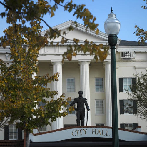
32°19′12″N 90°32′33″W / 32.32°N 90.5425°WBolton 19 City Hall 
November 25, 1969 203 S. President St.
32°17′52″N 90°10′56″W / 32.29778°N 90.18222°WJackson 20 City Mound (22Hi672) December 1, 1988 Address Restricted Jackson 21 Dupree House January 31, 1979 West of Raymond on Dupree Rd.
32°15′21″N 90°30′25″W / 32.25583°N 90.50694°WRaymond 22 Dupree Mound and Village Archeological Site November 25, 1969 Address Restricted Edwards 23 Dupree-Ratliff House July 15, 1986 101 Dupree St.
32°15′43″N 90°25′33″W / 32.26194°N 90.42583°WRaymond 24 East Clinton Historic District July 11, 1997 Roughly bounded by the Illinois Central railroad tracks, E. College, Landrum, E. Main, and New Prospect Sts.
32°20′16″N 90°19′50″W / 32.33778°N 90.33056°WClinton 25 Edwards Hotel 
November 7, 1976 Capitol and Mill Sts.
32°17′59″N 90°11′25″W / 32.29972°N 90.19028°WJackson 26 Medgar Evers House 
December 5, 2000 2332 Margaret Walker Alexander Dr.
32°20′33″N 90°12′44″W / 32.3425°N 90.21222°WJackson 27 Farish Street Neighborhood Historic District March 13, 1980 Roughly bounded by Amite, Mill, Fortification, and Lamar Sts.; also roughly bounded by Amite, Lamar, Mill and Fortification Sts.
32°18′24″N 90°11′16″W / 32.30667°N 90.18778°WJackson Second set of boundaries represents a boundary increase of September 18, 1980 28 Floyd Mound November 25, 1969 Address Restricted Bovina 29 Fountainhead November 28, 1980 306 Glen Way
32°20′9″N 90°10′8″W / 32.33583°N 90.16889°WJackson 30 James M. Futch House March 12, 1992 Dry Grove Rd., 1½ miles south of its junction with Mississippi Highway 18
32°13′9″N 90°25′31″W / 32.21917°N 90.42528°WRaymond 31 Galloway-Williams House October 10, 1985 427 E. Fortification St.
32°18′42″N 90°10′50″W / 32.31167°N 90.18056°WJackson 32 George Street Grocery July 8, 2010 416 George St.
32°18′23″N 90°10′55″W / 32.30639°N 90.18194°WJackson 33 Gibbs-Von Seutter House July 15, 1986 Southern side of Dupree St.
32°15′42″N 90°25′33″W / 32.26167°N 90.42583°WRaymond 34 Garner Wynn Green House October 31, 1985 647 N. State St.
32°18′20″N 90°10′45″W / 32.30556°N 90.17917°WJackson 35 Greenwood Cemetery 
December 20, 1984 Bounded by West, Davis, Lamar, and George Sts.
32°18′30″N 90°11′0″W / 32.30833°N 90.183333°WJackson 36 R.H. Henry Bridge June 8, 2005 U.S. Route 80 at the Big Black River
32°20′51″N 90°41′49″W / 32.3475°N 90.69694°WEdwards 37 Hinds County Armory December 1, 2000 1012 Mississippi St.
32°18′7″N 90°10′27″W / 32.30194°N 90.17417°WJackson 38 Hinds County Courthouse July 31, 1986 Pascagoula St.
32°17′48″N 90°10′58″W / 32.29667°N 90.18278°WJackson 39 Hinds County Courthouse 
July 15, 1986 E. Main and N. Oak Sts.
32°15′37″N 90°25′24″W / 32.26028°N 90.42333°WRaymond 40 Holly Grove Plantation House November 7, 1996 1056 Old Bridgeport Rd.
32°23′25″N 90°25′4″W / 32.39028°N 90.41778°WBolton 41 Houses at 500, 505, 512 and 513 North State Street November 7, 1995 500, 505, 512, and 513 N. State St.
32°18′13″N 90°10′45″W / 32.30361°N 90.17917°WJackson 42 Illinois Central Railroad Depot July 15, 1986 E. Main and Railroad Sts.
32°15′30″N 90°25′18″W / 32.25833°N 90.42167°WRaymond 43 Illinois Central Railroad Depot 
November 5, 2001 102 Railroad Ave.
32°5′42″N 90°17′35″W / 32.095°N 90.29306°WTerry 44 Dudley Jones House August 2, 1984 115 Railroad Ave.
32°5′42″N 90°17′41″W / 32.095°N 90.29472°WTerry 45 Keith Press Building July 15, 1986 234 Town Sq.
32°15′35″N 90°25′21″W / 32.25972°N 90.4225°WRaymond 46 Lebanon Presbyterian Church November 18, 1999 Lebanon Presbyterian Church Rd.
32°8′55″N 90°31′22″W / 32.14861°N 90.52278°WUtica 47 A.J. Lewis House August 4, 1983 S. Magnolia and Lewis Sts.
32°19′48″N 90°36′14″W / 32.33°N 90.60389°WEdwards 48 Ervin Lewis House December 1, 1989 5461 Old Byram Rd.
32°10′52″N 90°14′36″W / 32.18111°N 90.24333°WByram 49 Liberty Hall March 19, 2008 22822 Mississippi Highway 27
32°3′43.5″N 90°29′6.12″W / 32.062083°N 90.4850333°WCrystal Springs 50 Lorena Duling School July 3, 2007 622 Duling Ave.
32°20′16″N 90°10′30″W / 32.33778°N 90.175°WJackson 51 Magnolia Vale November 17, 1983 Off Mississippi Highway 18
32°12′17″N 90°28′24″W / 32.20472°N 90.47333°WRaymond 52 Main Hall July 15, 1986 Northwest of Cain Hall
32°15′19″N 90°25′2″W / 32.25528°N 90.41722°WRaymond 53 Manship House 
October 18, 1972 412 E. Fortification St.
32°18′45″N 90°10′53″W / 32.3125°N 90.18139°WJackson 54 McNair Plantation May 3, 1982 Southeast of Raymond on Mississippi Highway 18
32°10′19″N 90°30′30″W / 32.17194°N 90.50833°WRaymond 55 Merrill-Maley House April 29, 1982 739 N. State St.
32°18′27″N 90°10′44″W / 32.3075°N 90.17889°WJackson 56 Millsaps-Buie House June 19, 1973 628 N. State St.
32°18′18″N 90°10′43″W / 32.305°N 90.17861°WJackson 57 Mississippi Federation of Women's Clubs June 30, 1988 2407 N. State St.
32°19′37″N 90°10′33″W / 32.32694°N 90.17583°WJackson 58 Mississippi Foundry and Machine Company Building July 16, 2008 300 W. South St.
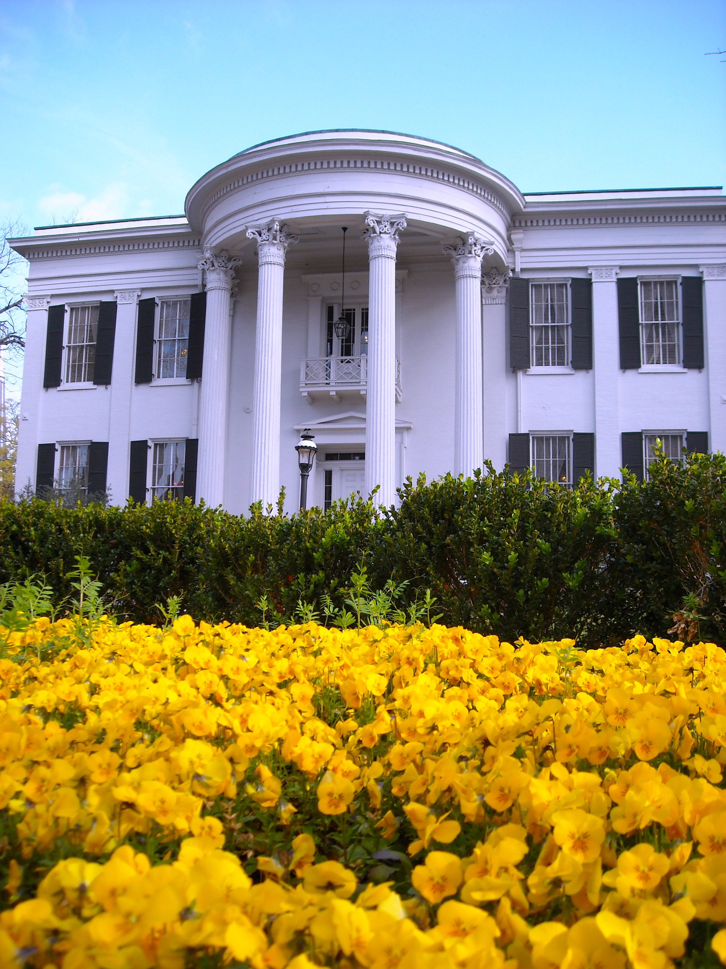
32°20′24.77″N 90°10′1.93″W / 32.3402139°N 90.1672028°WJackson 59 Mississippi Governor's Mansion 
November 25, 1969 316 E. Capitol St.
32°18′0″N 90°11′0″W / 32.3°N 90.183333°WJackson 60 Mississippi State Capitol 
November 25, 1969 Fronting Mississippi St., between N. President and N. West Sts.
32°18′56″N 90°11′49″W / 32.31556°N 90.19694°WJackson The "New Capitol" building, built in 1903 61 Joseph Henry Morris House August 11, 1983 305 N. State St.
32°18′13″N 90°10′47″W / 32.30361°N 90.17972°WJackson 62 N&W Overall Company Building November 14, 2007 736 S. President St.
32°17′33″N 90°10′58″W / 32.2925°N 90.18278°WJackson 63 Naval and Marine Corps Reserve Center November 19, 2002 181 S. Jefferson St.
32°18′0″N 90°10′42″W / 32.3°N 90.17833°WJackson 64 New Orleans Great Northern Railroad Passenger Depot March 1, 1996 618 Pearl St.
32°17′54″N 90°10′45″W / 32.29833°N 90.17917°WJackson 65 North Manor Apartments March 3, 1995 909 North St.
32°18′37″N 90°10′37″W / 32.31028°N 90.17694°WJackson 66 The Oaks 
May 25, 1973 823 N. Jefferson St.
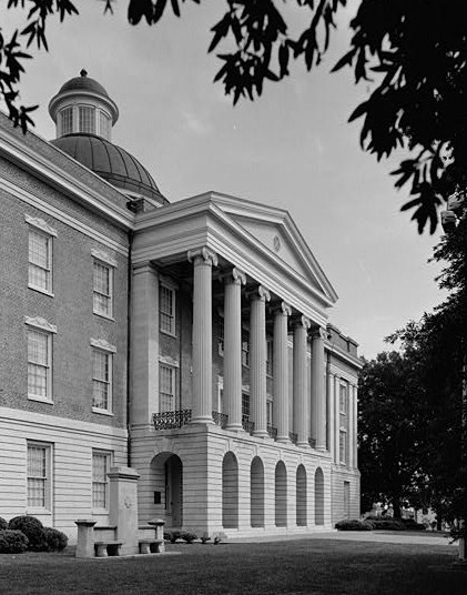
32°18′32″N 90°10′34″W / 32.30889°N 90.17611°WJackson 67 Old State Capitol 
November 25, 1969 100 N. State St.
32°17′59″N 90°10′47″W / 32.29972°N 90.17972°WJackson 68 Peyton House 
October 3, 1973 North of Raymond on Clinton Rd.
32°16′1″N 90°25′12″W / 32.26694°N 90.42°WRaymond 69 Phoenix Hall-Johnson-Harper House July 15, 1986 527 E. Palestine St.
32°15′12″N 90°25′9″W / 32.25333°N 90.41917°WRaymond 70 Pocahontas Mound A 
November 25, 1969 In a park along U.S. Route 49, near its junction with Interstate 220
32°28′9.6″N 90°17′18″W / 32.469333°N 90.28833°W[5]Pocahontas 71 Pocahontas Mound B April 11, 1972 Address Restricted Pocahontas 72 Poindexter Park Historic District June 9, 1995 Roughly bounded by W. Pearl St., Rose St., Hunt St., W. Capitol St., and Clifton St.
32°18′6″N 90°11′53″W / 32.30167°N 90.19806°WJackson 73 Porter House July 15, 1986 233 North Oak St.
32°15′41″N 90°25′21″W / 32.26139°N 90.4225°WRaymond 74 Raymond Battlefield Site January 13, 1972 2.5 miles southwest of Raymond on Mississippi Highway 18
32°14′30″N 90°27′0″W / 32.24167°N 90.45°WRaymond Site of the Battle of Raymond 75 Raymond Historic District July 27, 2007 Roughly Town Sq., with parts of E. Main, Palestine, Cooper's Well, Clinton, Oak, Court, W. Main, Dupree, and Port Gibson
32°15′34.03″N 90°25′22.37″W / 32.2594528°N 90.4228806°WRaymond 76 Smith Robertson Elementary School December 13, 1978 528 Bloom St.
32°18′19″N 90°11′11″W / 32.30528°N 90.18639°WJackson 77 Saint Mark's Episcopal Church July 15, 1986 W. Main and N. Oak Sts.
32°15′38″N 90°25′26″W / 32.26056°N 90.42389°WRaymond 78 Shelton House July 15, 1986 561 W. Main St.
32°16′0″N 90°25′40″W / 32.266667°N 90.42778°WRaymond 79 Sims House March 31, 1983 513 N. State St.
32°18′14″N 90°10′46″W / 32.30389°N 90.17944°WJackson 80 Smith Park Architectural District April 23, 1976 Irregular pattern along N. West and N. Congress Sts. between Capitol St. and the state capitol; also 225 E. Capitol St.; also 308 E. Pearl St.
32°18′2″N 90°11′0″W / 32.30056°N 90.183333°WJackson Capitol and Pearl addresses represent boundary increases of October 29, 1993 and March 24, 2004 respectively 81 Southern Christian Institute 
January 30, 2007 18449 Old U.S. Route 80, W.
32°20′16.9″N 90°38′15.57″W / 32.338028°N 90.6376583°WEdwards 82 Spengler's Corner October 20, 1977 101 N. State St.
32°17′57″N 90°10′49″W / 32.29917°N 90.18028°WJackson 83 Spengler's Corner Historic District November 15, 1979 E. Capitol, N. State, and N. President Sts
32°17′57″N 90°10′50″W / 32.29917°N 90.18056°WJackson 84 Spengler-Thomas Building May 9, 2003 129 S. President
32°18′0″N 90°10′55″W / 32.3°N 90.18194°WJackson 85 Sub Rosa April 28, 1975 South of Pocahontas on U.S. Route 49
32°26′31″N 90°17′35″W / 32.44194°N 90.29306°WPocahontas 86 Virden-Patton House 
December 16, 1983 512 N. State St.
32°18′13″N 90°10′44″W / 32.30361°N 90.17889°WJackson 87 Warren-Guild-Simmons House January 11, 1979 734 Fairview St.
32°19′13″N 90°10′36″W / 32.32028°N 90.17667°WJackson 88 Eudora Welty House 
November 21, 2002 1119 Pinehurst St.
32°19′8″N 90°10′13″W / 32.31889°N 90.17028°WJackson 89 West Capitol Street Historic District March 13, 1980 Roughly bounded by railroad tracks and Amite, Roach, and Pearl Sts.
32°18′2″N 90°11′24″W / 32.30056°N 90.19°WJackson 90 Wiener House at 228 Ridge Drive November 2, 2009 228 Ridge Dr.
32°20′24.77″N 90°10′1.93″W / 32.3402139°N 90.1672028°WJackson 91 Alex Williams House July 3, 1979 937 N. Lamar St.
32°18′33″N 90°11′4″W / 32.30917°N 90.18444°WJackson 92 Woodrow Wilson Bridge November 16, 1988 Spans the Pearl River on Silas Brown St.
32°17′22″N 90°10′44″W / 32.28944°N 90.17889°WJackson Extends into Rankin County 93 Wolfe House June 22, 1989 401 Claiborne
32°5′48″N 90°17′56″W / 32.09667°N 90.29889°WTerry Former listing
Landmark name Image Date removed Location City or Town Summary 1 Armour Company Smokehouse and Distribution Plant November 12, 2009 320 W. Pearl St.
32°17′59″N 90°11′32″W / 32.29972°N 90.19222°WJackson Listed November 25, 1983 See also
- List of National Historic Landmarks in Mississippi
- National Register of Historic Places listings in Mississippi
References
- ^ The latitude and longitude information provided in this table was derived originally from the National Register Information System, which has been found to be fairly accurate for about 99% of listings. For about 1% of NRIS original coordinates, experience has shown that one or both coordinates are typos or otherwise extremely far off; some corrections may have been made. A more subtle problem causes many locations to be off by up to 150 yards, depending on location in the country: most NRIS coordinates were derived from tracing out latitude and longitudes off of USGS topographical quadrant maps created under the North American Datum of 1927, which differs from the current, highly accurate WGS84 GPS system used by Google maps. Chicago is about right, but NRIS longitudes in Washington are higher by about 4.5 seconds, and are lower by about 2.0 seconds in Maine. Latitudes differ by about 1.0 second in Florida. Some locations in this table may have been corrected to current GPS standards.
- ^ "National Register of Historic Places: Weekly List Actions". National Park Service, United States Department of the Interior. Retrieved on November 10, 2011.
- ^ Numbers represent an ordering by significant words. Various colorings, defined here, differentiate National Historic Landmark sites and National Register of Historic Places Districts from other NRHP buildings, structures, sites or objects.
- ^ "National Register Information System". National Register of Historic Places. National Park Service. 2009-03-13. http://nrhp.focus.nps.gov/natreg/docs/All_Data.html.
- ^ Location derived from this National Park Service webpage; the NRIS lists the site as "Address Restricted"
U.S. National Register of Historic Places Topics Lists by states Alabama • Alaska • Arizona • Arkansas • California • Colorado • Connecticut • Delaware • Florida • Georgia • Hawaii • Idaho • Illinois • Indiana • Iowa • Kansas • Kentucky • Louisiana • Maine • Maryland • Massachusetts • Michigan • Minnesota • Mississippi • Missouri • Montana • Nebraska • Nevada • New Hampshire • New Jersey • New Mexico • New York • North Carolina • North Dakota • Ohio • Oklahoma • Oregon • Pennsylvania • Rhode Island • South Carolina • South Dakota • Tennessee • Texas • Utah • Vermont • Virginia • Washington • West Virginia • Wisconsin • WyomingLists by territories Lists by associated states Other Municipalities and communities of Hinds County, Mississippi Cities 
Towns Unincorporated
communitiesBrownsville | Dabney Crossroads | Oakley | Pocahontas | Turkey Creek
Footnotes ‡ This populated place also has portions in an adjacent county or counties
Categories:- Hinds County, Mississippi
- National Register of Historic Places in Mississippi by county
- Buildings and structures in Hinds County, Mississippi
-


Wikimedia Foundation. 2010.