- National Register of Historic Places listings in Hoonah–Angoon Census Area, Alaska
-
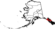
 Location of the Hoonah-Angoon Census Area in Alaska
This is a list of the National Register of Historic Places listings in Hoonah–Angoon Census Area, Alaska.
This is intended to be a complete list of the properties and districts on the National Register of Historic Places in Hoonah-Angoon Census Area, Alaska, United States. The locations of National Register properties and districts for which the latitude and longitude coordinates are included below, may be seen in a Google map.[1]
There are 19 properties and districts listed on the National Register in the census area.
-
- This National Park Service list is complete through NPS recent listings posted November 10, 2011.[2]
Current listings
[3] Landmark name[4] Image Date listed Location Community Summary 1 Alexander Lake Shelter Cabin November 2, 1995 Admiralty Island National Monument
57°39′47″N 134°8′31″W / 57.66306°N 134.14194°WAngoon 2 Beaver Lake Dam November 2, 1995 Admiralty Island National Monument
57°40′30″N 134°13′7″W / 57.675°N 134.21861°WAngoon 3 Big Shaheen Cabin November 2, 1995 Admiralty Island National Monument
57°42′7″N 134°16′28″W / 57.70194°N 134.27444°WAngoon 4 Davidson Lake Shelter Cabin November 2, 1995 Admiralty Island National Monument
57°36′17″N 134°22′39″W / 57.60472°N 134.3775°WAngoon 5 Distin Lake Shelter Cabin November 2, 1995 Admiralty Island National Monument
57°26′59″N 134°24′13″W / 57.44972°N 134.40361°WAngoon 6 Hasselborg Cabin November 2, 1995 Admiralty Island National Monument
58°32′40″N 134°4′42″W / 58.54444°N 134.07833°WAngoon 7 Hasselborg Lake East Shelter Cabin November 2, 1995 Admiralty Island National Monument
57°40′5″N 134°12′50″W / 57.66806°N 134.21389°WAngoon 8 Hasselborg Lake North Shelter Cabin November 2, 1995 Admiralty Island National Monument
57°46′2″N 134°19′9″W / 57.76722°N 134.31917°WAngoon 9 Hasselborg Lake South Shelter Cabin November 2, 1995 Admiralty Island National Monument
57°39′55″N 134°5′11″W / 57.66528°N 134.08639°WAngoon 10 Lake Guerin East Shelter Cabin November 2, 1995 Admiralty Island National Monument
57°39′37″N 134°17′4″W / 57.66028°N 134.28444°WAngoon 11 Lake Guerin West Shelter Cabin November 2, 1995 Admiralty Island National Monument
57°38′58″N 134°20′24″W / 57.64944°N 134.34°WAngoon 12 Mitchell Bay Shelter Cabin November 2, 1995 Admiralty Island National Monument
57°33′53″N 134°23′48″W / 57.56472°N 134.39667°WAngoon 13 Mole Harbor Shelter Cabin November 2, 1995 Admiralty Island National Monument
57°39′36″N 134°5′54″W / 57.66°N 134.09833°WAngoon 15 St. John the Baptist Church 
June 6, 1980 In Angoon
57°30′14″N 134°35′3″W / 57.50389°N 134.58417°WAngoon 16 Thayer Lake East Shelter Cabin November 2, 1995 Admiralty Island National Monument
57°38′3″N 134°27′45″W / 57.63417°N 134.4625°WAngoon 17 Thayer Lake North Shelter Cabin November 2, 1995 Admiralty Island National Monument
57°41′24″N 134°24′35″W / 57.69°N 134.40972°WAngoon 18 Thayer Lake South Shelter Cabin November 2, 1995 Admiralty Island National Monument
57°35′52″N 134°28′5″W / 57.59778°N 134.46806°WAngoon 19 Windfall Harbor Shelter Cabin November 2, 1995 Admiralty Island National Monument
57°50′11″N 134°18′22″W / 57.83639°N 134.30611°WAngoon vicinity CCC Historic Properties in Alaska MPS; proposed move approved December 6, 2010 See also
- List of National Historic Landmarks in Alaska
- National Register of Historic Places listings in Alaska
References
- ^ The latitude and longitude information provided in this table was derived originally from the National Register Information System, which has been found to be fairly accurate for about 99% of listings. For about 1% of NRIS original coordinates, experience has shown that one or both coordinates are typos or otherwise extremely far off; some corrections may have been made. A more subtle problem causes many locations to be off by up to 150 yards, depending on location in the country: most NRIS coordinates were derived from tracing out latitude and longitudes off of USGS topographical quadrant maps created under the North American Datum of 1927, which differs from the current, highly accurate WGS84 GPS system used by Google maps. Chicago is about right, but NRIS longitudes in Washington are higher by about 4.5 seconds, and are lower by about 2.0 seconds in Maine. Latitudes differ by about 1.0 second in Florida. Some locations in this table may have been corrected to current GPS standards.
- ^ "National Register of Historic Places: Weekly List Actions". National Park Service, United States Department of the Interior. Retrieved on November 10, 2011.
- ^ Numbers represent an ordering by significant words. Various colorings, defined here, differentiate National Historic Landmark sites and National Register of Historic Places Districts from other NRHP buildings, structures, sites or objects.
- ^ "National Register Information System". National Register of Historic Places. National Park Service. 2008-04-24. http://nrhp.focus.nps.gov/natreg/docs/All_Data.html.
U.S. National Register of Historic Places Topics Lists by states Alabama • Alaska • Arizona • Arkansas • California • Colorado • Connecticut • Delaware • Florida • Georgia • Hawaii • Idaho • Illinois • Indiana • Iowa • Kansas • Kentucky • Louisiana • Maine • Maryland • Massachusetts • Michigan • Minnesota • Mississippi • Missouri • Montana • Nebraska • Nevada • New Hampshire • New Jersey • New Mexico • New York • North Carolina • North Dakota • Ohio • Oklahoma • Oregon • Pennsylvania • Rhode Island • South Carolina • South Dakota • Tennessee • Texas • Utah • Vermont • Virginia • Washington • West Virginia • Wisconsin • WyomingLists by territories Lists by associated states Other Properties on the National Register of Historic Places in Alaska  Boroughs
 Census areasAleutians West • Bethel • Dillingham • Hoonah-Angoon • Nome • Petersburg • Prince of Wales-Hyder • Southeast Fairbanks • Valdez-Cordova • Yukon-KoyukukThere are no sites listed on the National Register of Historic Places in Wade Hampton Census Area
Municipalities and communities of Hoonah-Angoon Census Area, Alaska Cities Angoon | Gustavus | Hoonah | Pelican | Tenakee Springs
CDPs Unincorporated
communityCategories:- National Register of Historic Places in Alaska by borough and census area
- Hoonah–Angoon Census Area, Alaska
-


Wikimedia Foundation. 2010.