- National Register of Historic Places listings in Huntingdon County, Pennsylvania
-
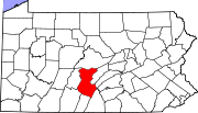
 Location of Huntingdon County in Pennsylvania
This is a list of the National Register of Historic Places listings in Huntingdon County, Pennsylvania.
This is intended to be a complete list of the properties and districts on the National Register of Historic Places in Huntingdon County, Pennsylvania, United States. The locations of National Register properties and districts for which the latitude and longitude coordinates are included below, may be seen in a Google map.[1]
There are 42 properties and districts listed on the National Register in the county. Two sites are further designated as National Historic Landmarks.
-
- This National Park Service list is complete through NPS recent listings posted November 10, 2011.[2]
Current listings
[3] Landmark name Image Date listed Location City or town Summary 1 H.O. Andrews Feed Mill March 20, 1990 West Main Street
40°23′42″N 77°56′35″W / 40.395°N 77.943056°WMapleton 2 Baker Bridge March 20, 1990 Township Route 370 over Great Trough Creek, 1 mile (1.6 km) east of Newburg
40°17′10″N 78°07′17″W / 40.286111°N 78.121389°WTodd Township 3 Barree Forge and Furnace March 20, 1990 2 miles (3.2 km) north of Alexandria along the Juniata River
40°35′18″N 78°06′04″W / 40.588333°N 78.101111°WPorter Township 4 Birmingham Bridge 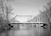
March 20, 1990 Over the Juniata River, north of Birmingham off Pennsylvania Route 350
40°38′56″N 78°11′57″W / 40.648889°N 78.199167°WWarriors Mark Township Extends into Tyrone Township in Blair County 5 Brumbaugh Homestead March 28, 1979 Northeast of Marklesburg off Pennsylvania Route 26
40°23′35″N 78°08′30″W / 40.393056°N 78.141667°WPenn Township 6 Colerain Forges Mansion March 20, 1990 Pennsylvania Route 45, 0.75 miles (1.21 km) south of Franklinville
40°38′20″N 78°06′00″W / 40.638889°N 78.1°WFranklin Township 7 Corbin Bridge 
March 20, 1990 Township Road 428 over the Raystown Branch, southwest of Huntingdon and 0.5 miles (0.80 km) west of its confluence with the Juniata River
40°27′16″N 77°59′00″W / 40.454444°N 77.983333°WJuniata Township 8 East Broad Top Railroad 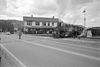
October 15, 1966 1 mile (1.6 km) west of Orbisonia on U.S. Route 522 Multiple[4] Extends into Broad Top Township in Bedford County 9 Frehn Bridge March 20, 1990 Township Route 313, 2 miles (3.2 km) west of Pennsylvania Route 475
40°08′00″N 77°59′29″W / 40.133333°N 77.991389°WSpringfield Township 10 Greenwood Furnace 
November 13, 1989 Pennsylvania Route 305 in Greenwood Furnace State Park, east of McAlevys Fort
40°38′48″N 77°46′41″W / 40.646667°N 77.778056°WJackson Township 11 Greenwood Lake Dam May 11, 1987 5 miles (8.0 km) north of Belleville off Pennsylvania Route 305
40°38′55″N 77°45′32″W / 40.648611°N 77.758889°WJackson Township 12 Harbison-Walker Refractories Company 
March 20, 1990 West Shirley Street
40°23′10″N 77°53′23″W / 40.386111°N 77.889722°WMount Union 13 Hudson Grist Mill March 20, 1990 Pennsylvania Route 829
40°12′49″N 78°00′27″W / 40.213611°N 78.0075°WSaltillo 14 Huntingdon Armory December 22, 1989 Standing Stone Avenue, east of Huntingdon
40°29′06″N 77°59′36″W / 40.485°N 77.993333°WHuntingdon County 15 Huntingdon Borough Historic District 
April 24, 1986 Roughly bounded by Moore, Second, Allegheny, and Ninth Streets
40°29′10″N 78°00′41″W / 40.486111°N 78.011389°WHuntingdon 16 Huntingdon Furnace 
March 20, 1990 Township Road 31106 northwest of Franklinville, 2 miles (3.2 km) northwest of its junction with Pennsylvania Route 45
40°39′28″N 78°06′59″W / 40.657778°N 78.116389°WFranklin Township 17 Juniata Iron Works March 20, 1990 Off Pennsylvania Route 885, 1.5 miles (2.4 km) east of Alexandria
40°32′32″N 78°05′08″W / 40.542222°N 78.085556°WPorter Township 18 Benjamin B. Leas House February 23, 1984 U.S. Route 522
40°17′56″N 77°52′18″W / 40.298889°N 77.871667°WShirleysburg 19 Lloyd and Henry Warehouse March 20, 1990 South 8th Street
40°29′11″N 78°01′05″W / 40.486389°N 78.018056°WHuntingdon 20 Marklesburg Historic District February 16, 1996 Junction of Pennsylvania Route 26 and Legislative Route 3010
40°22′57″N 78°10′22″W / 40.3825°N 78.172778°WMarklesburg 21 Minersville Coke Ovens March 20, 1990 Pennsylvania Route 913, 1 mile (1.6 km) east of Coalmont
40°13′00″N 78°11′03″W / 40.216667°N 78.184167°WCarbon Township 22 Monroe Furnace November 13, 1989 Junction of Pennsylvania Route 26 and Legislative Route 31076, 6 miles (9.7 km) northwest of McAlevys Fort
40°41′43″N 77°53′41″W / 40.695278°N 77.894722°WBarree Township 23 Mount Union Historic District 
May 26, 1994 Roughly bounded by Water and Greene Streets, the I.O.O.F. Cemetery, and Washington and Lafayette Streets
40°23′06″N 77°53′03″W / 40.385°N 77.884167°WMount Union 24 Christian Oyer Jr. House July 21, 1995 Township Road 513, northeast of Huntingdon
40°36′34″N 77°53′54″W / 40.609444°N 77.898333°WBarree Township 25 Paradise Furnace March 20, 1990 5 miles (8.0 km) southeast of Entriken in Trough Creek State Park
40°18′39″N 78°07′34″W / 40.310833°N 78.126111°WTodd Township 26 Pennsylvania Canal Guard Lock and Feeder Dam, Raystown Branch March 20, 1990 2.5 miles (4.0 km) east of Huntingdon, south of U.S. Route 22 on the Juniata River
40°26′59″N 77°58′09″W / 40.449722°N 77.969167°WHenderson Township 27 Pennsylvania Furnace Mansion 
March 20, 1990 Off Pennsylvania Route 45 at Pennsylvania Furnace, south of the Centre County line
40°42′13″N 78°00′47″W / 40.703611°N 78.013056°WFranklin Township 28 Pennsylvania Railroad Bridge over Shavers Creek March 20, 1990 Over Shavers Creek near its confluence with the Juniata River
40°34′01″N 78°02′54″W / 40.566944°N 78.048333°WLogan Township and Petersburg 29 Pennsylvania Railroad District March 20, 1990 Conrail mile markers 213.73 to 218.88
40°36′47″N 78°09′07″W / 40.613056°N 78.151944°WSpruce Creek Township 30 Pennsylvania Railroad Old Bridge over Standing Stone Creek 
March 20, 1990 South of Penn Street over Standing Stone Creek
40°28′51″N 78°00′17″W / 40.480833°N 78.004722°WHuntingdon 31 Pulpit Rocks 
November 4, 1993 Old Huntingdon-Hollidaysburg Turnpike, northwest of Huntingdon
40°31′09″N 78°02′43″W / 40.519167°N 78.045278°WPorter Township 32 Robb Farm April 20, 2011 11023 Hartslog Valley Road
40°28′31″N 78°5′27.5″W / 40.47528°N 78.090972°WWalker Township 33 Robertsdale Historic District 
May 7, 1992 Roughly bounded by the USGS 1840 contour line and South Main, Wood, Lincoln, Cliff, and Cherry Streets, in Robertsdale
40°11′01″N 78°06′45″W / 40.183611°N 78.1125°WWood Township 34 Runk Bridge 
March 20, 1990 Over Aughwick Creek, 1 mile (1.6 km) south of Shirleysburg off U.S. Route 522
40°16′40″N 77°53′14″W / 40.277778°N 77.887222°WShirley Township 35 St. Mary's Covered Bridge March 20, 1980 4.5 miles (7.2 km) south of Orbisonia on U.S. Route 522
40°12′21″N 77°52′42″W / 40.205833°N 77.878333°WCromwell Township 36 Hugh D. and Martha South Seeds Farm March 12, 1999 Legislative Route 31061, 1 mile (1.6 km) east of Pemberton
40°37′45″N 78°09′06″W / 40.629167°N 78.151667°WSpruce Creek Township 37 Shade Gap Feed and Flour Mill March 20, 1990 U.S. Route 522, 1 mile (1.6 km) north of Shade Gap
40°11′14″N 77°52′08″W / 40.187222°N 77.868889°WDublin Township 38 Lewis Smalley Homestead November 14, 1978 East of Allenport on Pennsylvania Route 103
40°21′40″N 77°49′52″W / 40.361111°N 77.831111°WShirley Township 39 Spruce Creek Rod and Gun Club February 28, 1991 Pennsylvania Route 45, northeast of Franklinville
40°40′28″N 78°02′52″W / 40.674444°N 78.047778°WFranklin Township 40 Warrior Ridge Dam and Hydroelectric Plant 
April 26, 1990 2 miles (3.2 km) south of Petersburg, along the former Conrail main line
40°32′22″N 78°02′03″W / 40.539444°N 78.034167°WLogan and Porter Townships 41 Whipple Dam State Park Day Use District February 12, 1987 10 miles (16 km) south of State College, east of Pennsylvania Route 26
40°41′05″N 77°51′53″W / 40.684722°N 77.864722°WJackson Township 42 Woodvale Historic District 
July 24, 1992 Roughly bounded by Ash, High, North, Fulton, and Broad Streets in Woodvale
40°10′01″N 78°08′17″W / 40.166944°N 78.138056°WWood Township Extends into Broad Top Township in Bedford County and Wells Township in Fulton County See also
- List of National Historic Landmarks in Pennsylvania
- National Register of Historic Places listings in Pennsylvania
- List of Pennsylvania state historical markers in Huntingdon County
References
- ^ The latitude and longitude information provided in this table was derived originally from the National Register Information System, which has been found to be fairly accurate for about 99% of listings. For about 1% of NRIS original coordinates, experience has shown that one or both coordinates are typos or otherwise extremely far off; some corrections may have been made. A more subtle problem causes many locations to be off by up to 150 yards, depending on location in the country: most NRIS coordinates were derived from tracing out latitude and longitudes off of USGS topographical quadrant maps created under the North American Datum of 1927, which differs from the current, highly accurate WGS84 GPS system used by Google maps. Chicago is about right, but NRIS longitudes in Washington are higher by about 4.5 seconds, and are lower by about 2.0 seconds in Maine. Latitudes differ by about 1.0 second in Florida. Some locations in this table may have been corrected to current GPS standards.
- ^ "National Register of Historic Places: Weekly List Actions". National Park Service, United States Department of the Interior. Retrieved on November 10, 2011.
- ^ Numbers represent an ordering by significant words. Various colorings, defined here, differentiate National Historic Landmark sites and National Register of Historic Places Districts from other NRHP buildings, structures, sites or objects.
- ^ Extends through Clay Township, Cromwell Township, Mount Union, Rockville, Shirley Township, Shirleysburg, Three Springs, Todd Township, and Wood Township
Municipalities and communities of Huntingdon County, Pennsylvania Boroughs Alexandria | Birmingham | Broad Top City | Cassville | Coalmont | Dudley | Huntingdon | Mapleton | Marklesburg | Mill Creek | Mount Union | Orbisonia | Petersburg | Rockhill | Saltillo | Shade Gap | Shirleysburg | Three Springs
Townships Unincorporated
communitiesAllenport | Ardenheim | Hesston | McConnellstown | Robertsdale | Spruce Creek
Categories:- Huntingdon County, Pennsylvania
- National Register of Historic Places in Pennsylvania by county
-


Wikimedia Foundation. 2010.