- National Register of Historic Places listings in Lake County, Ohio
-
 Location of Lake County in Ohio
This is a list of the National Register of Historic Places listings in Lake County, Ohio.
This is intended to be a complete list of the properties and districts on the National Register of Historic Places in Lake County, Ohio, United States. The locations of National Register properties and districts for which the latitude and longitude coordinates are included below, may be seen in a Google map.[1]
There are 77 properties and districts listed on the National Register in the county, including 1 National Historic Landmark.
-
- This National Park Service list is complete through NPS recent listings posted November 10, 2011.[2]
Current listings
[3] Landmark name [4] Image Date listed Location City or town Summary 1 Administration Building, Lake Erie College 
March 20, 1973 391 W. Washington St.
41°43′03″N 81°15′06″W / 41.7175°N 81.251667°WPainesville 2 Brick Vernacular House No. 1 October 20, 1980 98 Lake St.
41°46′24″N 81°02′50″W / 41.773333°N 81.047222°WMadison 3 Brick Vernacular House No. 2 October 20, 1980 120 N. Lake St.
41°46′26″N 81°02′50″W / 41.773889°N 81.047222°WMadison 4 Casement House July 30, 1975 436 Casement Ave.
41°43′07″N 81°12′40″W / 41.718611°N 81.211111°WPainesville Township 5 Cheese-vat Factory October 20, 1980 16 Eagle St.
41°46′18″N 81°03′05″W / 41.771667°N 81.051389°WMadison 6 Alpha Charles Childs House October 20, 1980 319 W. Main St.
41°46′14″N 81°03′17″W / 41.770556°N 81.054722°WMadison 7 Robertus W. Childs House October 20, 1980 307 W. Main St.
41°46′14″N 81°03′16″W / 41.770556°N 81.054444°WMadison 8 Connecticut Land Company Office August 14, 1973 7071 E. Main St. in Unionville
41°46′46″N 81°00′31″W / 41.779444°N 81.008611°WMadison Township 9 Corning-White House November 7, 1972 8353 Mentor Ave.
41°39′58″N 81°20′31″W / 41.666111°N 81.341944°WMentor 10 Harry Coulby Mansion August 24, 1979 28730 Ridge Rd.
41°35′43″N 81°28′41″W / 41.595278°N 81.478056°WWickliffe 11 George Damon House October 20, 1980 841 W. Main St.
41°46′08″N 81°03′54″W / 41.768889°N 81.065°WMadison 12 James Dayton House October 20, 1980 939 W. Main St.
41°46′08″N 81°03′15″W / 41.768889°N 81.054167°WMadison 13 James Dayton House II October 20, 1980 417 W. Main St.
41°46′12″N 81°03′24″W / 41.77°N 81.056667°WMadison 14 Albert DeHeck House October 20, 1980 431 W. Main St.
41°46′12″N 81°03′26″W / 41.77°N 81.057222°WMadison 15 Downtown Willoughby Historic District November 29, 1995 Approximately nine blocks centered around the junction of Erie and River Sts. and Euclid Ave.
41°38′21″N 81°24′25″W / 41.639167°N 81.406944°WWilloughby 16 Fairport Harbor West Breakwater Light 
April 10, 1992 Western breakwater pierhead at harbor entrance, northeast of Fairport Harbor
41°46′02″N 81°16′53″W / 41.767222°N 81.281389°WPainesville Township 17 Fairport Marine Museum November 5, 1971 129 2nd St.
41°45′25″N 81°16′39″W / 41.756944°N 81.2775°WFairport Harbor 18 Claud Foster House June 16, 2004 30333 Lake Shore Blvd.
41°38′21″N 81°28′37″W / 41.639167°N 81.476944°WWillowick 19 Frances Ensign Fuller House October 20, 1980 790 W. Main St.
41°46′11″N 81°03′57″W / 41.769722°N 81.065833°WMadison 20 Garfield Library February 23, 1979 7300 Center St.
41°40′19″N 81°20′25″W / 41.671944°N 81.340278°WMentor 21 Jane Gilbert House October 20, 1980 189-195 W. Main St.
41°46′15″N 81°03′06″W / 41.770833°N 81.051667°WMadison 22 H. Gill House October 20, 1980 232 River St.
41°46′01″N 81°02′58″W / 41.766944°N 81.049444°WMadison 23 Norma Grantham Site (33-La-139) May 31, 1984 600 metres (2,000 ft) south of the Fairport Harbor Village Site,[5] along East Street about 0.75 miles (1.21 km) south of Lake Erie
41°44′27″N 81°16′8″W / 41.74083°N 81.26889°W[6]Fairport Harbor 24 Gray-Coulton House December 3, 1975 8607-8617 Mentor Ave.
41°40′11″N 81°19′56″W / 41.669722°N 81.332222°WMentor 25 Lucius Green House July 12, 1976 4160 Main St.
41°45′32″N 81°08′22″W / 41.758889°N 81.139444°WPerry 26 Leonard C. Hanna, Jr., Estate March 12, 1979 Little Mountain Rd.
41°38′25″N 81°19′02″W / 41.640278°N 81.317222°WKirtland Hills 27 Francis Hendry House October 20, 1980 239-243 W. Main St.
41°46′15″N 81°03′10″W / 41.770833°N 81.052778°WMadison 28 Indian Point Fort July 30, 1974 East of Painesville
41°43′13″N 81°10′17″W / 41.720278°N 81.171389°WLeRoy Township 29 Cyrus J. Ingersoll House October 20, 1980 249 W. Main St.
41°46′14″N 81°03′11″W / 41.770556°N 81.053056°WMadison 30 James A. Garfield National Historic Site 
October 15, 1966 8095 Mentor Ave.
41°39′44″N 81°20′50″W / 41.66222°N 81.34722°WMentor 31 John J. Jones House October 20, 1980 298 Lake St.
41°46′37″N 81°02′50″W / 41.776944°N 81.047222°WMadison 32 John Kellogg House and Barn October 20, 1980 30 E. Main St.
41°46′15″N 81°02′45″W / 41.770833°N 81.045833°WMadison 33 Addison Kimball House March 27, 1975 390 W. Main St.
41°46′15″N 81°03′23″W / 41.770833°N 81.056389°WMadison 34 Lemuel Kimball, II, House October 15, 1974 467 W. Main St.
41°46′12″N 81°03′29″W / 41.77°N 81.058056°WMadison 35 Solomon Kimball House October 20, 1980 391 W. Main St.
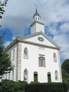
41°46′13″N 81°03′23″W / 41.770278°N 81.056389°WMadison 36 Kirtland Temple 
June 4, 1969 9020 Chillicothe Rd.
41°37′31″N 81°21′44″W / 41.625278°N 81.362222°WKirtland 37 Ladd's Tavern May 22, 1978 5466 S. Ridge Rd.
41°45′46″N 81°05′36″W / 41.762778°N 81.093333°WMadison Township 38 Lake Shore and Michigan Southern RR Depot and Freight House January 31, 1978 8445 Station St.
41°40′44″N 81°20′18″W / 41.678889°N 81.338333°WMentor 39 Lutz's Tavern April 23, 1973 792 Mentor Ave.
41°42′47″N 81°15′36″W / 41.713056°N 81.26°WPainesville 40 William Lyman House October 20, 1980 734 W. Main St.
41°46′11″N 81°03′49″W / 41.769722°N 81.063611°WMadison 41 Madison Fort July 30, 1974 On a ridge between the Grand River and Mill Creek, southeast of Madison[7] Madison Township 42 Madison Seminary and Home February 22, 1979 North of central Madison at 6769 Middle Ridge Rd.
41°47′25″N 81°02′45″W / 41.790278°N 81.045833°WMadison 43 James Mason House September 18, 1975 8125 Mentor Ave.
41°39′52″N 81°20′57″W / 41.664444°N 81.349167°WMentor 44 Mathews House April 23, 1973 309 W. Washington St.
41°43′09″N 81°14′59″W / 41.719167°N 81.249722°WPainesville 45 Mentor Avenue District 
August 3, 1978 Wood St. and Mentor Ave. from Liberty to Washington St.
41°43′17″N 81°14′56″W / 41.721389°N 81.248889°WPainesville 46 Mentor Village School February 9, 2005 7482 Center St.
41°40′01″N 81°20′26″W / 41.666944°N 81.340556°WMentor 47 Rev. Harlan Metcalf House October 20, 1980 275 W. Main St.
41°46′14″N 81°03′14″W / 41.770556°N 81.053889°WMadison 48 Methodist Episcopal Church of Painesville January 30, 1998 71 N. Park Place
41°43′31″N 81°14′40″W / 41.725278°N 81.244444°WPainesville 49 Edward W. and Louise C. Moore Estate March 10, 1988 7960 Garfield Rd.
41°38′19″N 81°21′24″W / 41.638611°N 81.356667°WKirtland 50 Lewis Morley House March 30, 1978 231 N. State St.
41°43′47″N 81°14′40″W / 41.729722°N 81.244444°WPainesville 51 Norfolk and Western Freight Station October 20, 1980 Lake St.
41°46′29″N 81°02′48″W / 41.774722°N 81.046667°WMadison 52 Old South Church September 20, 1973 9802 Chillicothe Rd.
41°36′16″N 81°21′01″W / 41.604444°N 81.350278°WKirtland 53 John G. Oliver House October 1, 1981 7645 Little Mountain Rd.
41°39′40″N 81°19′30″W / 41.661111°N 81.325°WMentor 54 David R. Paige House December 23, 1975 21-29 W. Main St.
41°46′16″N 81°02′53″W / 41.771111°N 81.048056°WMadison 55 Painesville City Hall July 24, 1972 7 Richmond St.
41°43′27″N 81°14′45″W / 41.724167°N 81.245833°WPainesville 56 George Pease House October 20, 1980 553 W. Main St.
41°46′11″N 81°03′34″W / 41.769722°N 81.059444°WMadison 57 Louis A. Penfield House 
February 7, 1997 2203 River Rd.
41°37′09″N 81°24′31″W / 41.619167°N 81.408611°WWilloughby Hills 58 Sawyer-Wayside House October 29, 1974 9470 Mentor Ave.
41°40′50″N 81°18′01″W / 41.680556°N 81.300278°WMentor 59 Uri Seeley House August 14, 1973 969 Riverside Dr.
41°42′54″N 81°12′30″W / 41.715°N 81.208333°WPainesville 60 Orland Selby House October 20, 1980 564 E. Main St.
41°46′27″N 81°02′05″W / 41.774167°N 81.034722°WMadison 61 Sessions House August 14, 1973 157 Mentor Ave.
41°42′45″N 81°14′55″W / 41.7125°N 81.248611°WPainesville 62 Smart Building September 29, 1983 4143-4145 Erie St.
41°38′22″N 81°24′24″W / 41.639444°N 81.406667°WWilloughby 63 Smead House November 21, 1974 187 Mentor Ave.
41°43′15″N 81°15′01″W / 41.720833°N 81.250278°WPainesville 64 David Smead House October 20, 1980 269 E. Main St.
41°46′24″N 81°02′28″W / 41.773333°N 81.041111°WMadison 65 South Leroy Meetinghouse May 8, 1979 Southeast of Painesville at State Route 86 and Brakeman Rd.
41°39′50″N 81°08′49″W / 41.663889°N 81.146944°WLeRoy Township 66 St. James Episcopal Church July 7, 1975 141 N. State St.
41°43′41″N 81°14′36″W / 41.728056°N 81.243333°WPainesville 67 Joseph Talcott House October 20, 1980 354 River St.
41°45′54″N 81°02′55″W / 41.765°N 81.048611°WMadison 68 Judge Abraham Tappan House May 8, 1979 7855 S. Ridge Rd. in Unionville
41°46′48″N 81°00′15″W / 41.78°N 81.004167°WMadison Township 69 Town Center District October 20, 1980 Main St. between River and Lake Sts.
41°46′16″N 81°02′56″W / 41.771111°N 81.048889°WMadison 70 Unionville District School December 29, 1978 3480 West St. in Unionville
41°46′45″N 81°00′24″W / 41.779167°N 81.006667°WMadison Township 71 Unionville Tavern 
July 26, 1973 On State Route 84 in Unionville
41°46′49″N 81°00′11″W / 41.780278°N 81.003056°WMadison Township 72 Edwin L. Ware House October 20, 1980 293 W. Main St.
41°46′14″N 81°03′15″W / 41.770556°N 81.054167°WMadison 73 Newel K. Whitney Store 
August 30, 1984 8881 Chillicothe Rd.
41°37′46″N 81°21′42″W / 41.629444°N 81.361667°WKirtland 74 George D. Wilson House October 20, 1980 367 River St.
41°45′54″N 81°02′53″W / 41.765°N 81.048056°WMadison 75 Dr. J. C. Winans House April 26, 1976 143 River St.
41°46′07″N 81°02′58″W / 41.768611°N 81.049444°WMadison 76 John and Carrie Yager House March 17, 1994 7612 S. Center St.
41°39′51″N 81°20′25″W / 41.664167°N 81.340278°WMentor 77 Benjamin and Mary Young House August 8, 1996 7597 S. Center St.
41°39′52″N 81°20′24″W / 41.664444°N 81.34°WMentor See also
References
- ^ The latitude and longitude information provided in this table was derived originally from the National Register Information System, which has been found to be fairly accurate for about 99% of listings. For about 1% of NRIS original coordinates, experience has shown that one or both coordinates are typos or otherwise extremely far off; some corrections may have been made. A more subtle problem causes many locations to be off by up to 150 yards, depending on location in the country: most NRIS coordinates were derived from tracing out latitude and longitudes off of USGS topographical quadrant maps created under North American Datum of 1927, which differs from the current, highly accurate GPS system used by Google maps. Chicago is about right, but NRIS longitudes in Washington are higher by about 4.5 seconds, and are lower by about 2.0 seconds in Maine. Latitudes differ by about 1.0 second in Florida. Some locations in this table may have been corrected to current GPS standards.
- ^ "National Register of Historic Places: Weekly List Actions". National Park Service, United States Department of the Interior. Retrieved on November 10, 2011.
- ^ Numbers represent an ordering by significant words. Various colorings, defined here, differentiate National Historic Landmark sites and National Register of Historic Places Districts from other NRHP buildings, structures, sites or objects.
- ^ "National Register Information System". National Register of Historic Places. National Park Service. . http://nrhp.focus.nps.gov/natreg/docs/All_Data.html.
- ^ Watson, Anna Louise. "Normality and the Aging Process in the Thoracic Spine: Two Late Prehistoric Ohio Populations". Thesis Ohio State U, 2009, 11.
- ^ Morgan, Richard G., and H. Holmes Ellis. "The Fairport Harbor Village Site, Ohio History 52 (1963): 3-4. The NRIS lists the site as "Address Restricted".
- ^ Location derived from this page of Ohio History; the NRIS lists the site as "Address Restricted"
Municipalities and communities of Lake County, Ohio County seat: Painesville Cities Eastlake | Kirtland | Mentor | Mentor-on-the-Lake | Painesville | Wickliffe | Willoughby | Willoughby Hills | Willowick

Villages Fairport Harbor | Grand River | Kirtland Hills | Lakeline | Madison | North Perry | Perry | Timberlake | Waite Hill
Townships Concord | LeRoy | Madison | Painesville | Perry
CDP Unincorporated
communitiesCategories:- National Register of Historic Places in Ohio by county
- Lake County, Ohio
-


Wikimedia Foundation. 2010.