- National Register of Historic Places listings in Logan County, Oklahoma
-
 Location of Logan County in Oklahoma
This is a list of the National Register of Historic Places listings in Logan County, Oklahoma.
This is intended to be a complete list of the properties and districts on the National Register of Historic Places in Logan County, Oklahoma, United States. The locations of National Register properties and districts for which the latitude and longitude coordinates are included below, may be seen in a Google map.[1]
There are 13 properties and districts listed on the National Register in the county, including 1 National Historic Landmark.
-
- This National Park Service list is complete through NPS recent listings posted November 10, 2011.[2]
Current listings
[3] Landmark name [4] Image Date listed Location City or town Summary 1 Carnegie Library 
June 21, 1971 Oklahoma Ave. and Ash St.
35°52′48″N 97°25′05″W / 35.88°N 97.418056°WGuthrie 2 Co-Operative Publishing Company Building March 7, 1973 Harrison Ave. and 2nd St.
35°52′39″N 97°25′32″W / 35.8775°N 97.425556°WGuthrie 3 Angie Debo House April 4, 1996 200 Oklahoma Ave.
36°09′18″N 97°37′23″W / 36.155°N 97.623056°WMarshall 4 Guthrie Armory September 8, 1994 720 E. Logan
35°53′01″N 97°25′00″W / 35.883611°N 97.416667°WGuthrie 5 Guthrie Historic District 
June 13, 1974 Roughly bounded by 14th St., College Ave., Pine St., and Lincoln Ave.
35°52′22″N 97°25′29″W / 35.872778°N 97.424722°WGuthrie 6 Langston University Cottage Row Historic District January 7, 1999 Southwestern corner of the Langston University campus
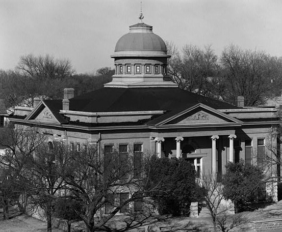
35°56′36″N 97°15′47″W / 35.943333°N 97.263056°WLangston 7 Logan County Courthouse October 26, 1984 301 E. Harrison St.
35°52′36″N 97°25′19″W / 35.876667°N 97.421944°WGuthrie 8 Methodist Church of Marshall September 28, 1984 Off State Highway 74
36°09′17″N 97°37′22″W / 36.154722°N 97.622778°WMarshall 9 Morris House September 8, 1994 221 Tolson Boulevard
35°56′38″N 97°15′17″W / 35.943889°N 97.254722°WLangston 10 Mulhall United Methodist Church June 22, 1984 Bryant and Craig Sts.
36°03′48″N 97°24′13″W / 36.063333°N 97.403611°WMulhall 11 Oklahoma State Bank Building June 22, 1984 Baty and Main Sts.
36°03′54″N 97°24′26″W / 36.065°N 97.407222°WMulhall 12 St. Joseph Convent and Academy December 19, 1979 Off State Highway 33
35°52′15″N 97°27′37″W / 35.870833°N 97.460278°WGuthrie 13 Scottish Rite Temple April 9, 1987 900 E. Oklahoma
35°52′41″N 97°24′48″W / 35.878056°N 97.413333°WGuthrie See also
- List of National Historic Landmarks in Oklahoma
- National Register of Historic Places listings in Oklahoma
References
- ^ The latitude and longitude information provided in this table was derived originally from the National Register Information System, which has been found to be fairly accurate for about 99% of listings. For about 1% of NRIS original coordinates, experience has shown that one or both coordinates are typos or otherwise extremely far off; some corrections may have been made. A more subtle problem causes many locations to be off by up to 150 yards, depending on location in the country: most NRIS coordinates were derived from tracing out latitude and longitudes off of USGS topographical quadrant maps created under the North American Datum of 1927, which differs from the current, highly accurate WGS84 GPS system used by Google maps. Chicago is about right, but NRIS longitudes in Washington are higher by about 4.5 seconds, and are lower by about 2.0 seconds in Maine. Latitudes differ by about 1.0 second in Florida. Some locations in this table may have been corrected to current GPS standards.
- ^ "National Register of Historic Places: Weekly List Actions". National Park Service, United States Department of the Interior. Retrieved on November 10, 2011.
- ^ Numbers represent an ordering by significant words. Various colorings, defined here, differentiate National Historic Landmark sites and National Register of Historic Places Districts from other NRHP buildings, structures, sites or objects.
- ^ "National Register Information System". National Register of Historic Places. National Park Service. . http://nrhp.focus.nps.gov/natreg/docs/All_Data.html.
U.S. National Register of Historic Places Topics Lists by states Alabama • Alaska • Arizona • Arkansas • California • Colorado • Connecticut • Delaware • Florida • Georgia • Hawaii • Idaho • Illinois • Indiana • Iowa • Kansas • Kentucky • Louisiana • Maine • Maryland • Massachusetts • Michigan • Minnesota • Mississippi • Missouri • Montana • Nebraska • Nevada • New Hampshire • New Jersey • New Mexico • New York • North Carolina • North Dakota • Ohio • Oklahoma • Oregon • Pennsylvania • Rhode Island • South Carolina • South Dakota • Tennessee • Texas • Utah • Vermont • Virginia • Washington • West Virginia • Wisconsin • WyomingLists by territories Lists by associated states Other Municipalities and communities of Logan County, Oklahoma Cities 
Towns Unincorporated
communitiesBarnes | Cimarron City | Lovell | Navina | Seward | Waterloo
Footnotes ‡This populated place also has portions in an adjacent county or counties
Categories:- Logan County, Oklahoma
- National Register of Historic Places in Oklahoma by county
- Buildings and structures in Logan County, Oklahoma
-


Wikimedia Foundation. 2010.