- National Register of Historic Places listings in Lynchburg, Virginia
-
This list includes properties and districts listed on the National Register of Historic Places in Lynchburg, Virginia. Click the "Map of all coordinates" link to the right to view a Google map of all properties and districts with latitude and longitude coordinates in the table below.[1]
-
- This National Park Service list is complete through NPS recent listings posted November 10, 2011.[2]
[3] Landmark name Image Date listed Location City or town Summary 1 Academy of Music 
June 11, 1969 522-526 Main St.
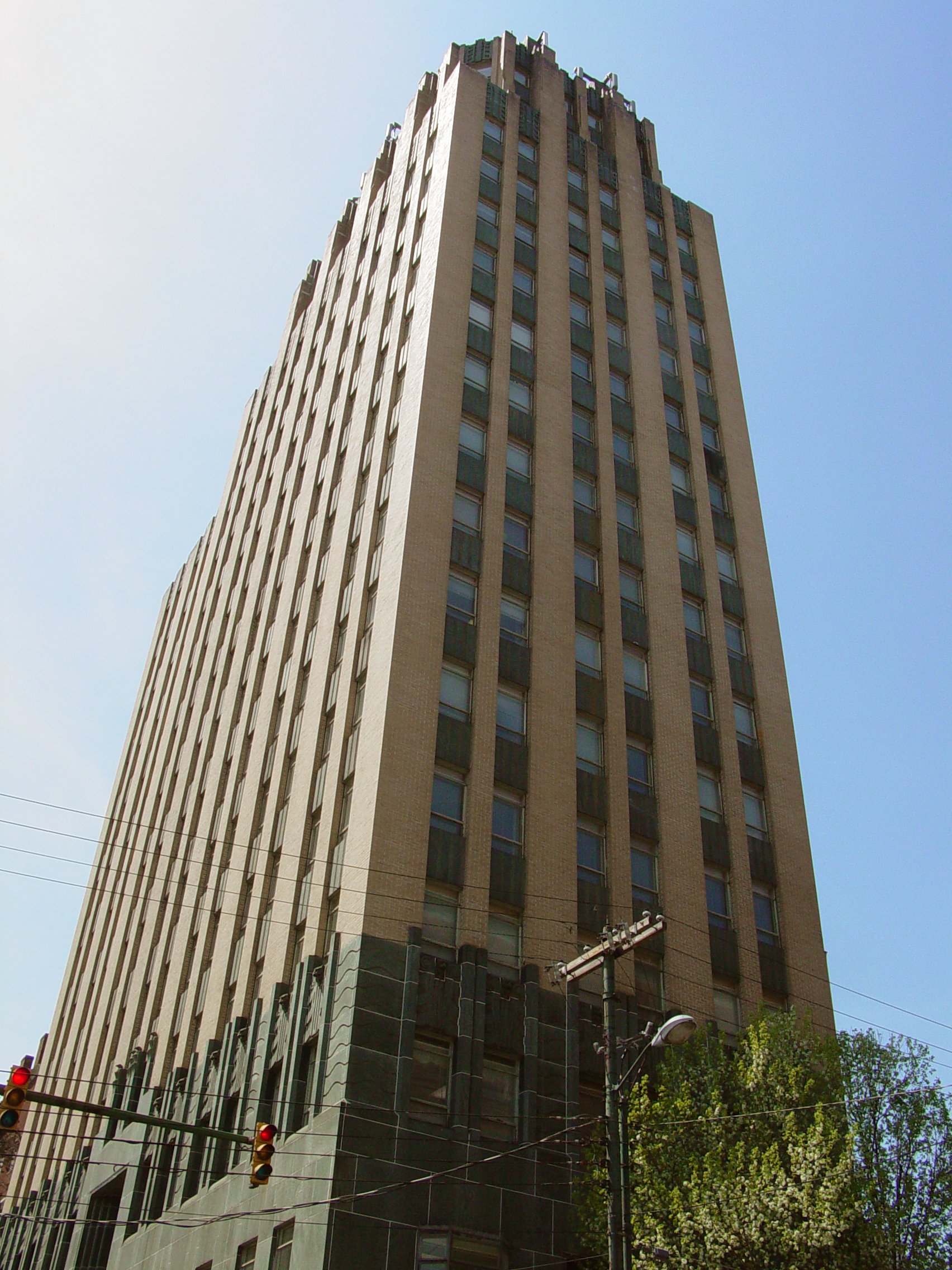
37°25′1″N 79°8′44″W / 37.41694°N 79.14556°WLynchburg 2 Allied Arts Building 
December 19, 1985 725 Church St.
37°24′52″N 79°8′39″W / 37.41444°N 79.14417°WLynchburg 3 Aviary 
July 30, 1980 402 Grove St.
37°24′8″N 79°9′47″W / 37.40222°N 79.16306°WLynchburg 4 Bragassa Toy Store 
January 11, 1991 323-325 Twelfth St.
37°24′41″N 79°8′32″W / 37.41139°N 79.14222°WLynchburg 5 Centerview 
December 1, 2000 1900 Memorial Ave.
37°24′30″N 79°9′43″W / 37.40833°N 79.16194°WLynchburg 6 Court House Hill-Downtown Historic District 
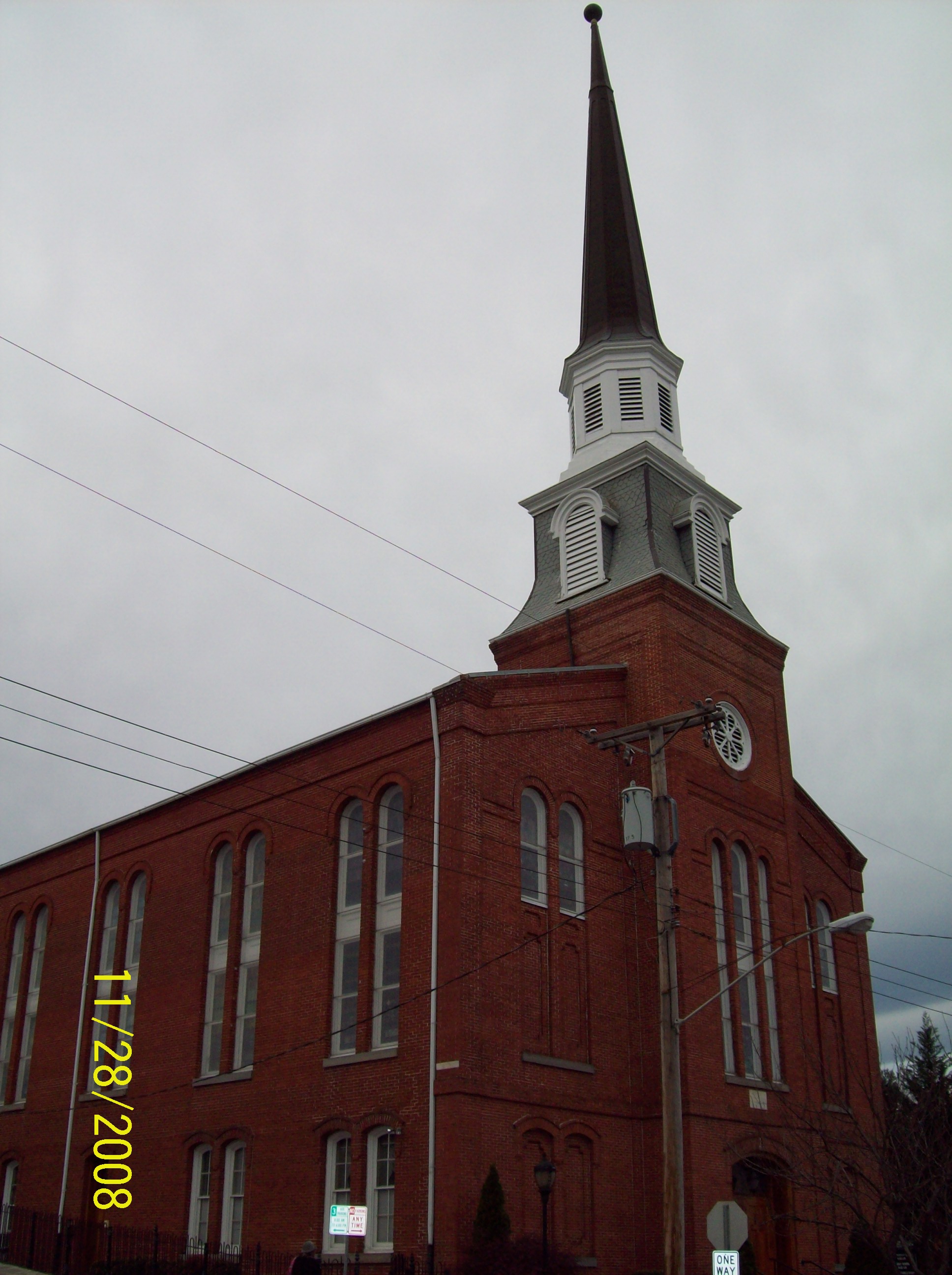
August 16, 2001 Church, Clay, Court, Main Sts., roughly bounded by 5th through 13th Sts. Lynchburg 7 Court Street Baptist Church 
July 8, 1982 6th and Court Sts.
37°24′58″N 79°8′50″W / 37.41611°N 79.14722°WLynchburg 8 Daniel's Hill Historic District 
February 24, 1983 Cabell, Norwood, Hancock, Stonewall from 6th to H St.
37°25′21″N 79°8′45″W / 37.4225°N 79.14583°WLynchburg 9 Diamond Hill Baptist Church February 22, 2011 1415 Grace St.
37°24′27″N 79°8′38″W / 37.4075°N 79.14389°WLynchburg 10 Diamond Hill Historic District 
October 1, 1979 Roughly bounded by Dunbar Dr., Main, Jackson and Arch Sts.
37°24′31″N 79°8′23″W / 37.40861°N 79.13972°WLynchburg 11 Federal Hill Historic District 
September 17, 1980 Roughly bounded by 8th, 12th, Harrison and Polk Sts.
37°24′39″N 79°8′51″W / 37.41083°N 79.1475°WLynchburg 12 First Baptist Church 
September 9, 1982 1100 Court St.
37°24′43″N 79°8′33″W / 37.41194°N 79.1425°WLynchburg 13 Fort Early and Jubal Early Monument 
January 24, 2002 3511 Memorial Ave.
37°23′23″N 79°10′24″W / 37.38972°N 79.17333°WLynchburg 14 Garland Hill Historic District 
September 7, 1972 Bounded roughly by 5th St., Federal Ave., and Norfolk Western Ry. tracks
37°25′3″N 79°9′3″W / 37.4175°N 79.15083°WLynchburg 15 Carter Glass House 
December 8, 1976 605 Clay St.
37°24′55″N 79°8′51″W / 37.41528°N 79.1475°WLynchburg 16 Dr. Robert Walter Johnson House and Tennis Court 
January 24, 2002 1422 Pierce St.
37°24′43″N 79°9′2″W / 37.41194°N 79.15056°WLynchburg 17 Jones Memorial Library 
October 30, 1980 434 Rivermont Ave.
37°25′20″N 79°9′40″W / 37.42222°N 79.16111°WLynchburg 18 Kentucky Hotel 
December 11, 1986 900 Fifth St.
37°24′52″N 79°9′3″W / 37.41444°N 79.15083°WLynchburg 19 Locust Grove 
December 17, 1992 Marvin Pl.
37°26′26″N 79°14′59″W / 37.44056°N 79.24972°WLynchburg 20 Lower Basin Historic District 
April 24, 1987 700-1300 blks. of Jefferson St., 600-1300 blks. of Commerce St., and 1200-1300 Blks. of Main St.
37°24′52″N 79°8′21″W / 37.41444°N 79.13917°WLynchburg 21 Lynch's Brickyard House 
March 13, 2002 700 Jackson St.
37°24′45″N 79°9′0″W / 37.4125°N 79.15°WLynchburg 22 Lynchburg Courthouse 
May 19, 1972 9th St. between Court and Church Sts.
37°24′49″N 79°8′41″W / 37.41361°N 79.14472°WLynchburg 23 Lynchburg Hospital 
December 9, 1999 701-709 Hollins Mill Rd.
37°25′12″N 79°9′21″W / 37.42°N 79.15583°WLynchburg 24 Main Hall, Randolph-Macon Women's College 
June 19, 1979 2500 Rivermont Ave.
37°26′12″N 79°10′21″W / 37.43667°N 79.1725°WLynchburg 25 Samuel Miller House 
November 12, 1992 1433 Nelson Dr.
37°21′57″N 79°12′47″W / 37.36583°N 79.21306°WLynchburg 26 Miller-Claytor House 
May 6, 1976 Treasure Island Rd. at Miller-Claytor Lane
37°26′12″N 79°9′49″W / 37.43667°N 79.16361°WLynchburg 27 Montview 
June 5, 1987 Liberty University campus between VA 670 and US 29
37°21′10″N 79°10′43″W / 37.35278°N 79.17861°WLynchburg 28 Old City Cemetery 
April 2, 1973 4th, Monroe, 1st Sts. and Southern RR. tracks
37°24′54″N 79°9′24″W / 37.415°N 79.15667°WLynchburg 29 William Phaup House 
March 13, 2002 911 Sixth St.
37°24′48″N 79°9′6″W / 37.41333°N 79.15167°WLynchburg 30 Point of Honor 
February 26, 1970 112 Cabell St.
37°25′13″N 79°8′39″W / 37.42028°N 79.14417°WLynchburg 31 Presbyterian Orphans Home 
June 24, 2010 150 Linden Ave.
37°26′50″N 79°11′42″W / 37.44722°N 79.195°WLynchburg 32 Pyramid Motors 
November 1, 2007 405-407 Federal St.
37°24′56″N 79°9′6″W / 37.41556°N 79.15167°WLynchburg 33 Rivermont 
May 11, 2000 205 F St.
37°25′29″N 79°8′50″W / 37.42472°N 79.14722°WLynchburg 34 Rivermont Historic District 
April 11, 2003 Rivermont Ave
37°25′43″N 79°9′29″W / 37.42861°N 79.15806°WLynchburg 35 Rosedale 
July 7, 1983 Old Graves Mill Rd.
37°22′34″N 79°13′44″W / 37.37611°N 79.22889°WLynchburg 36 Saint Paul's Vestry House 
February 21, 1997 308 7th St.
37°24′53″N 79°8′40″W / 37.41472°N 79.14444°WLynchburg 37 Sandusky House 
July 26, 1982 757 Sandusky Dr.
37°22′48″N 79°11′49″W / 37.38°N 79.19694°WLynchburg 38 South River Friends Meetinghouse 
August 28, 1975 5810 Fort Ave.
37°22′23″N 79°11′32″W / 37.37306°N 79.19222°WLynchburg 39 Anne Spencer House 
December 6, 1976 1313 Pierce St.
37°24′13″N 79°9′8″W / 37.40361°N 79.15222°WLynchburg 40 St. Paul's Church 
September 9, 1982 605 Clay St.
37°24′54″N 79°8′51″W / 37.415°N 79.1475°WLynchburg 41 Virginia Episcopal School 
October 28, 1992 400 Virginia Episcopal School Rd.
37°27′11″N 79°11′26″W / 37.45306°N 79.19056°WLynchburg 42 Virginia University of Lynchburg February 22, 2011 2058 Garfield Ave.
37°23′43″N 79°9′7″W / 37.39528°N 79.15194°WLynchburg 43 John Marshall Warwick House 
December 6, 1996 720 Court St.
37°24′47″N 79°8′37″W / 37.41306°N 79.14361°WLynchburg 44 Western Hotel 
July 22, 1974 5th and Madison Sts.
37°24′57″N 79°8′57″W / 37.41583°N 79.14917°WLynchburg 45 J. W. Wood Building 
February 17, 1983 23-27 Ninth St.
37°24′58″N 79°8′26″W / 37.41611°N 79.14056°WLynchburg See also
- National Register of Historic Places listings in Virginia
- List of National Historic Landmarks in Virginia
References
- ^ The latitude and longitude information provided in this table was derived originally from the National Register Information System, which has been found to be fairly accurate for about 99% of listings. For about 1% of NRIS original coordinates, experience has shown that one or both coordinates are typos or otherwise extremely far off; some corrections may have been made. A more subtle problem causes many locations to be off by up to 150 yards, depending on location in the country: most NRIS coordinates were derived from tracing out latitude and longitudes off of USGS topographical quadrant maps created under the North American Datum of 1927, which differs from the current, highly accurate WGS84 GPS system used by Google maps. Chicago is about right, but NRIS longitudes in Washington are higher by about 4.5 seconds, and are lower by about 2.0 seconds in Maine. Latitudes differ by about 1.0 second in Florida. Some locations in this table may have been corrected to current GPS standards.
- ^ "National Register of Historic Places: Weekly List Actions". National Park Service, United States Department of the Interior. Retrieved on November 10, 2011.
- ^ Numbers represent an ordering by significant words. Various colorings, defined here, differentiate National Historic Landmark sites and National Register of Historic Places Districts from other NRHP buildings, structures, sites or objects.
U.S. National Register of Historic Places Topics Lists by states Alabama • Alaska • Arizona • Arkansas • California • Colorado • Connecticut • Delaware • Florida • Georgia • Hawaii • Idaho • Illinois • Indiana • Iowa • Kansas • Kentucky • Louisiana • Maine • Maryland • Massachusetts • Michigan • Minnesota • Mississippi • Missouri • Montana • Nebraska • Nevada • New Hampshire • New Jersey • New Mexico • New York • North Carolina • North Dakota • Ohio • Oklahoma • Oregon • Pennsylvania • Rhode Island • South Carolina • South Dakota • Tennessee • Texas • Utah • Vermont • Virginia • Washington • West Virginia • Wisconsin • WyomingLists by territories Lists by associated states Other Categories:- Lynchburg, Virginia
- National Register of Historic Places in Virginia
- Virginia-related lists
-


Wikimedia Foundation. 2010.