- National Register of Historic Places listings in Marquette County, Michigan
-
 Location of Marquette County in Michigan
This is a list of the National Register of Historic Places listings in Marquette County, Michigan.
This is intended to be a complete list of the properties and districts on the National Register of Historic Places in Marquette County, Michigan, United States. The locations of National Register properties and districts for which the latitude and longitude coordinates are included below, may be seen in a Google map.[1]
There are 32 properties and districts listed on the National Register in the county.
-
- This National Park Service list is complete through NPS recent listings posted November 10, 2011.[2]
Current listings
[3] Landmark name[4] Image Date listed Location City or Town Summary 1 Arch and Ridge Streets Historic District 
June 18, 1980 Arch and Ridge Sts. from Front St. to Lake Superior
46°32′43″N 87°23′6″W / 46.54528°N 87.385°WMarquette The Historic District includes spectacular residences built for some of the leading citizens of Marquette, as well as more modest houses for white- and blue-collar workers. The district dates from 1867, when Peter White built the first house on the Ridge. Most of the construction in the district took place over the next 35 years as other leading citizens of Marquette followed White's lead, including pioneer businessman and industrialist Hiram A. Burt, Charles H. Call, Daniel Merritt, Andrew Ripka, David Murray, Josiah Reynolds, Frank Bennett Spear, and James Jopling. 2 Big Bay Point Light Station 
October 12, 1988 3 Lighthouse Rd.
46°50′25″N 87°40′55″W / 46.84028°N 87.68194°WBig Bay The Big Bay Point Light stands on a tall bluff over a rocky point northwest of Marquette. The light went into service in 1896. It is the only operational lighthouse to include a bed and breakfast. 3 Call House 
January 13, 1972 450 E. Ridge St.
46°32′44″N 87°23′4″W / 46.54556°N 87.38444°WMarquette The Call House was designed and built in 1867 for Henry R. Mather, first president of the Cleveland Iron Mining Company. The house house is a particularly noteworthy example of Gothic Revival architecture, and was later used by U.S. Supreme Court Justice George Shiras Jr. as a summer home. 4 Cleveland Mine Engine House Number 3 
May 2, 2007 601 Division St.
46°29′20″N 87°39′31″W / 46.48889°N 87.65861°WIshpeming The Cleveland Mine was the second iron mine opened on the Marquette Iron Range after the Jackson Mine. The first portion of this engine house was built in 1880-1882, and served as the mine's primary hoist engine house until the ore was depleted in the early 1890s. The Cleveland Mine was eventually merged with other iron companies in the area, including the Jackson Mine and the Iron Cliffs Mine, to form the Cleveland-Cliffs Iron Company. 5 Cliffs Shaft Mine 
July 17, 1992 Euclid St. between Lakeshore Dr. and Spruce St.
46°29′28″N 87°40′31″W / 46.49111°N 87.67528°WIshpeming The Cliffs Shaft Mine operated on this site for a total of 99 years, closing in 1967. The site is now a museum. 6 Sam Cohodas Lodge 
April 4, 1991 Off US 41/M-28 at the eastern end of Lake Michigamme, Michigamme Township
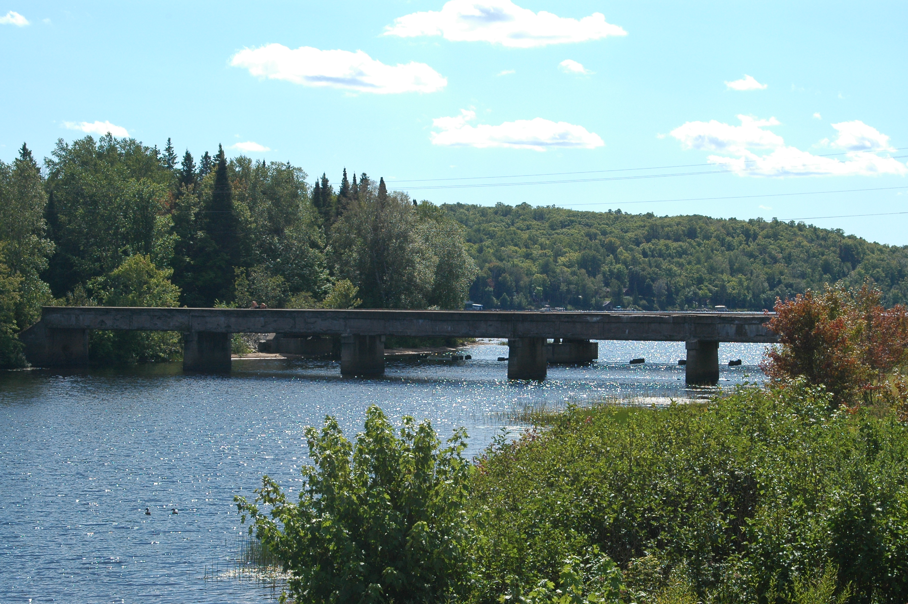
46°31′33″N 88°0′15″W / 46.52583°N 88.00417°WChampion The Sam Cohodas Lodge was built for Sam Cohodas, the head of a large and successfull fruit and produce wholesale firm, in 1934-35. The lodge, built from locally sourced material, in significant as a distinctive example of a large-scale, vernacular rustic log resort architecture constructed in the early 20th century. It is one of the largest log structures in Michigan which does not use an independent superstructure for support. 7 County Road 557 – West Branch Escanaba River Bridge December 17, 1999 County Road 557 over the West Branch of the Escanaba River
46°8′48″N 87°27′45″W / 46.14667°N 87.4625°WWells Township The County Road 557 – West Branch Escanaba River Bridge, constructed in 1928, is one of the first truly long steel stringer bridges constructed in the state. Recent improvements in the manufacture of rolled I-beams enabled lengthier spans to be constructed. The outside of the stringers are encased in concrete, giving the bridge the appearance af an all-concrete construction. 8 Granite Island Light Station 
August 4, 1983 12 mi (19 km) north of Marquette on Granite Island
46°43′15″N 87°24′43″W / 46.72083°N 87.41194°WMarquette The Granite Island Light was built in 1868 and commissioned in 1869. It is one of the oldest surviving lighthouses on Lake Superior. 9 Granot Loma April 4, 1991 County Road 550 on the Lake Superior shore north of Thoneys Pt., Powell Township
46°41′58″N 87°32′54″W / 46.69944°N 87.54833°WMarquette Granot Loma is a lodge constructed by Louis Graveraet Kaufman in the tradition of the Adirondack camps of the late nineteenth and early twentieth centuries. The estate includes 5,180 acres of woodland located along the Lake Superior shore; the lodge is built of logs over a steel frame and includes a 60-foot long greatroom and 26 bedrooms. 10 Gwinn Model Town Historic District 
June 24, 2002 Including most of the original plat of Gwinn and surrounding greenbelt
46°16′59″N 87°26′23″W / 46.28306°N 87.43972°WForsyth In 1906, the president of the Cleveland-Cliffs Iron Company, William Gwinn Mather, commissioned the well-known Boston landscape designer Warren H. Manning to design a residential community to support the mining operations. Manning designed a "model town," emphasizing Gwinn’s connection to the surrounding environment by preserving many of the existing trees and planting new ones. 11 Harlow Block 
March 24, 1983 100 W. Washington St.
46°32′37″N 87°23′34″W / 46.54361°N 87.39278°WMarquette The Harlow Block, built in an Italianate style, exemplifies late nineteenth century vernacular commercial architecture. It was constructed by one of Marquette's first settlers, Amos R. Harlow, in 1887 as a real estate investment. 12 Huron Islands Lighthouse 
September 2, 1975 Northwest of Big Bay in Lake Superior
46°57′48″N 87°59′58″W / 46.96333°N 87.99944°WBig Bay In 1867, Congress appropriated $17,000 for a lighthouse located in the Huron Islands. The survey crew chose the highest point on Lighthouse Island, the westernmost of the group as the location for the light. With the exception of 205 feet (62 m) Grand Island North Light, this is the highest focal plane in the western Great Lakes. The lighthouse was constructed in 1868, and is a duplicate of the one built at the same time on nearby Granite Island. 13 Ishpeming Municipal Building 
July 9, 1981 100 E. Division St.
46°29′18″N 87°40′5″W / 46.48833°N 87.66806°WIshpeming The City Hall in Ishpeming was built during the boom iron-mining years, constructed from 1889 to 1891 using a design by Milwaukee architect Demetrius F. Charlton. It is a two-story, rectangular structure built of Portage Entry sandstone with a rounded entry arch, decorative sandstone sills and lintels above and below the windows, and a decorative beltcourse between the floors. 14 Jackson Iron Company Site 
May 30, 1975 North of Negaunee limits off County Road 492
46°31′17″N 87°33′56″W / 46.52139°N 87.56556°WNegaunee The Jackson Iron Company Site, also known as the Carp River Forge, was the first forge constructed in northern Michigan, constructed in 1847-1848. The Carp River forge proved to be financially unprofitable, due in large part to the difficulties of transporting both iron ore and forge supplies to the forge site and the forge was closed for good and abandoned in 1854, having made "little iron and no money." 15 Jackson Mine 
September 3, 1971 West of Negaunee
46°29′55″N 87°37′22″W / 46.49861°N 87.62278°WNegaunee The Jackson Mine is an open pit iron mine, the first mine in the Lake Superior region. The Jackson Mining Company was organized in Jackson, Michigan in 1845; the first substantial ore removal cam in 1847. Although initial work was unrewarding, by 1861 the company was financially stable, abd was the foundation of the coty of Negaunee. 16 Longyear Building 
July 1, 2004 210 North Front St.
46°32′40″N 87°23′32″W / 46.54444°N 87.39222°WMarquette The Longyear Building is a commercial structure built in 1916. 17 Longyear Hall of Pedagogy-Northern Michigan University 
April 3, 1980 Presque Isle Ave.
46°33′22″N 87°23′52″W / 46.55611°N 87.39778°WMarquette Longyear Hall was originally built in 1899, and rebuilt after a fire in 1907. I t was the first location of Northern Normal School, now Northern Michigan University. Longyear Hall was demolished in 1993. 18 Old M-95 – Michigamme River Bridge December 17, 1999 Old M-95 over the Michigamme River
46°14′48″N 88°0′46″W / 46.24667°N 88.01278°WRepublic Township This bridge was built in 1910, and although modest in scale and design, it is technologically and historically significant as an embodiment of local bridge design before state standardization. It spans the Michigamme River on an abandoned roadway (now used as a private road) that was once M-95, immediately west of the current highway. 19 Marquette and Western Railroad Negaunee Freight Depot 
July 2, 2008 420 Rail St.
46°29′52″N 87°36′44″W / 46.49778°N 87.61222°WNegaunee This Negaunee depot was built in 1884 by the Marquette and Western Railroad as a freight and passenger depot. After only a year of service, the entire line was bought by a competitor, the Marquette, Houghton and Ontonagon Railroad. The structure was used as the main freight and passenger depot in Negaunee until it was replaced with a newer structure in 1922. 20 Marquette City Hall 
April 11, 1975 204 Washington St.
46°32′38″N 87°23′45″W / 46.54389°N 87.39583°WMarquette The Marquette City Hall was built in the early 1890s; the demand for bricks and sandstone was enough that the local economy was bolstered through the economic depression that lingered at that time. The city used the building until 1977, when it was sold to a private developer who refurbished it into professional offices. 21 Marquette County Courthouse 
March 29, 1978 400 S. 3rd St.
46°32′30″N 87°23′47″W / 46.54167°N 87.39639°WMarquette Built 1902-1904. The courtroom drama Anatomy of a Murder, starring Jimmy Stewart, was filmed on location here and throughout the Marquette area.[5][6] 22 Marquette Harbor Light Station 
July 19, 1984 Marquette Harbor
46°32′48″N 87°22′29″W / 46.54667°N 87.37472°WMarquette The existing structure was completed in 1865, replacing a previous lighthouse that had deteriorated. The lighthouse has been operated by the United States Coast Guard since 1891, and is now open for tours.[7] 23 Mather Inn 
December 20, 1978 107 Canda St.
46°29′30″N 87°40′5″W / 46.49167°N 87.66806°WIshpeming Realizing the benefit of having a first-class hotel, William G. Mather, president of Cleveland-Cliffs Iron Company, financed the construction of the Mather Inn after the 1928 destruction of an earlier hotel. Mather hired Boston architect James H. Ritchie to design the building and turned to Warren H. Manning, a longtime associate, to design the grounds. The hotel is considered to be an excellent example of the work of both men. 24 Negaunee Fire Station 
July 14, 2004 200 S. Pioneer Ave.
46°29′55″N 87°36′31″W / 46.49861°N 87.60861°WNegaunee Built in 1910, this fire house is still used as the headquarters of Negaunee's Volunteer Fire Department. 25 Negaunee State Bank Building 
April 13, 1995 331 Iron St.
46°29′55″N 87°36′37″W / 46.49861°N 87.61028°WNegaunee The Negaunee State Bank Building is a two-story structure with a triangular footprint. It was built in 1912 o nthe site of an earlier bank building destroyed by fire. The building housed the Negaunee State Bank until 1933, when the bank failed during the Great Depression. 26 Savings Bank Building 
September 13, 1978 101 S. Front St.
46°32′35″N 87°23′33″W / 46.54306°N 87.3925°WMarquette Built by Louis G. Kaufman, original co-owner/financier of the Empire State Building. It was designed by the architectural firm of Barber and Barber and built in 1892 by Noble and Benson for a cost of $174,000. The bank building is known for its landmark copper-clad clock tower and ornate stonework.[8] 27 Stannard Rock Lighthouse 
March 30, 1973 Off the Keweenaw Peninsula
47°11′1″N 87°13′5″W / 47.18361°N 87.21806°WLake Superior The Stannard Rock Light is built on an isolated rocky shoal located 45 miles north of Marquette in Lake Superior. It was constructed between 1877-1883 at the then-high cost of $305,000.[9] 28 Sundberg Block 
April 20, 2011 517-523 Iron St.
46°29′56″N 87°36′47″W / 46.49889°N 87.61306°WNegaunee Built by Charles Sundberg in 1890, this late Victorian commercial block was a focus of downtown Negaunee for years. It housed commercial enterprises, including Negaunee's first movie theatre, and was later used as a manufacturing facility and then a community center. 29 State House of Correction and Branch Prison 
November 23, 1977 Off US 41/M-28
46°30′44″N 87°22′57″W / 46.51222°N 87.3825°WMarquette Opened in 1889, it was renowned for its remote location and difficult, high-risk prisoners. Imposing sandstone edifice overlooking Lake Superior, notable for its architecture and landscaped gardens.[10] 30 Trunk Line Bridge No. 1 
December 17, 1999 Old US 41/M-28 over the Peshekee River
46°31′42″N 88°0′13″W / 46.52833°N 88.00361°WMichigamme Township Trunk Line Bridge No. 1 was the first bridge designed by Michigan Department of Transportation. The bridge was built in 1914 in response to the 1913 State Trunk Line Act passed by the Michigan Legislature. The bridge used to carry US 41/M-28 across the Pesheskee River near the river's mouth at Lake Michigamme, but has since been abandoned. 31 Upper Peninsula Brewing Company Building 
May 15, 1980 Meeske St. and US 41/M-28
46°32′49″N 87°25′22″W / 46.54694°N 87.42278°WMarquette Also known as the Charles Meeske House, this structure served as the home and office of brewer Charles Meeske, secretary-treasurer and later president of the Upper Peninsula Brewing Company Building. The building, a vernacular two-story rectangular Romanesque Revival structure built of variegated rough-cut sandstone, is the single structure remaining from the 1894 brewing company complex. 32 Vista Theater 
July 22, 2005 218 Iron St.
46°29′56″N 87°36′36″W / 46.49889°N 87.61°WNegaunee The Vista Theater was built by Negaunee businessman Jafet Rytkonen. Rytkonen was a partner in the Star, another Negaunee theater, but desired a larger and grander theatre than the Star was. In 1926, Rytkonen hired architect David E. Anderson to design the Vista; the new theatre opened on September 20, 1926. Rytkonen ran the theatre until his retirement in 1950, after which his son, William, and son-in-law, Peter Ghiardi, took over management of the Vista, which remained in operation until 1972. See also
- List of National Historic Landmarks in Michigan
- National Register of Historic Places listings in Michigan
References
- ^ The latitude and longitude information provided in this table was derived originally from the National Register Information System, which has been found to be fairly accurate for about 99% of listings. For about 1% of NRIS original coordinates, experience has shown that one or both coordinates are typos or otherwise extremely far off; some corrections may have been made. A more subtle problem causes many locations to be off by up to 150 yards, depending on location in the country: most NRIS coordinates were derived from tracing out latitude and longitudes off of USGS topographical quadrant maps created under the North American Datum of 1927, which differs from the current, highly accurate WGS84 GPS system used by Google maps. Chicago is about right, but NRIS longitudes in Washington are higher by about 4.5 seconds, and are lower by about 2.0 seconds in Maine. Latitudes differ by about 1.0 second in Florida. Some locations in this table may have been corrected to current GPS standards.
- ^ "National Register of Historic Places: Weekly List Actions". National Park Service, United States Department of the Interior. Retrieved on November 10, 2011.
- ^ Numbers represent an ordering by significant words. Various colorings, defined here, differentiate National Historic Landmark sites and National Register of Historic Places Districts from other NRHP buildings, structures, sites or objects.
- ^ "National Register Information System". National Register of Historic Places. National Park Service. 2008-04-24. http://nrhp.focus.nps.gov/natreg/docs/All_Data.html.
- ^ http://www.ers.usda.gov/Briefing/Population/Photos/ShowCH.asp?FIPS=26103
- ^ http://www.nmu.edu/anatomy50/
- ^ http://mqtmaritimemuseum.com/
- ^ http://www.nationalregisterofhistoricplaces.com/mi/Marquette/state.html
- ^ http://www.lighthousefriends.com/light.asp?ID=728
- ^ http://hunts-upguide.com/marquette_marquette_branch_prison.html
U.S. National Register of Historic Places Topics Lists by states Alabama • Alaska • Arizona • Arkansas • California • Colorado • Connecticut • Delaware • Florida • Georgia • Hawaii • Idaho • Illinois • Indiana • Iowa • Kansas • Kentucky • Louisiana • Maine • Maryland • Massachusetts • Michigan • Minnesota • Mississippi • Missouri • Montana • Nebraska • Nevada • New Hampshire • New Jersey • New Mexico • New York • North Carolina • North Dakota • Ohio • Oklahoma • Oregon • Pennsylvania • Rhode Island • South Carolina • South Dakota • Tennessee • Texas • Utah • Vermont • Virginia • Washington • West Virginia • Wisconsin • WyomingLists by territories Lists by associated states Other Categories:- National Register of Historic Places in Michigan by county
- Marquette County, Michigan
- Buildings and structures in Marquette County, Michigan
-


Wikimedia Foundation. 2010.