- National Register of Historic Places listings in McKean County, Pennsylvania
-
 Location of McKean County in Pennsylvania
This is a list of the National Register of Historic Places listings in McKean County, Pennsylvania.
This is intended to be a complete list of the properties and districts on the National Register of Historic Places in McKean County, Pennsylvania, United States. The locations of National Register properties and districts for which the latitude and longitude coordinates are included below, may be seen in a Google map.[1]
There are 10 properties and districts listed on the National Register in the county.
-
- This National Park Service list is complete through NPS recent listings posted November 10, 2011.[2]
Current listings
[3] Landmark name[4] Image Date listed Location Municipality Summary 1 Anoatok 
January 7, 1986 230 Clay Street
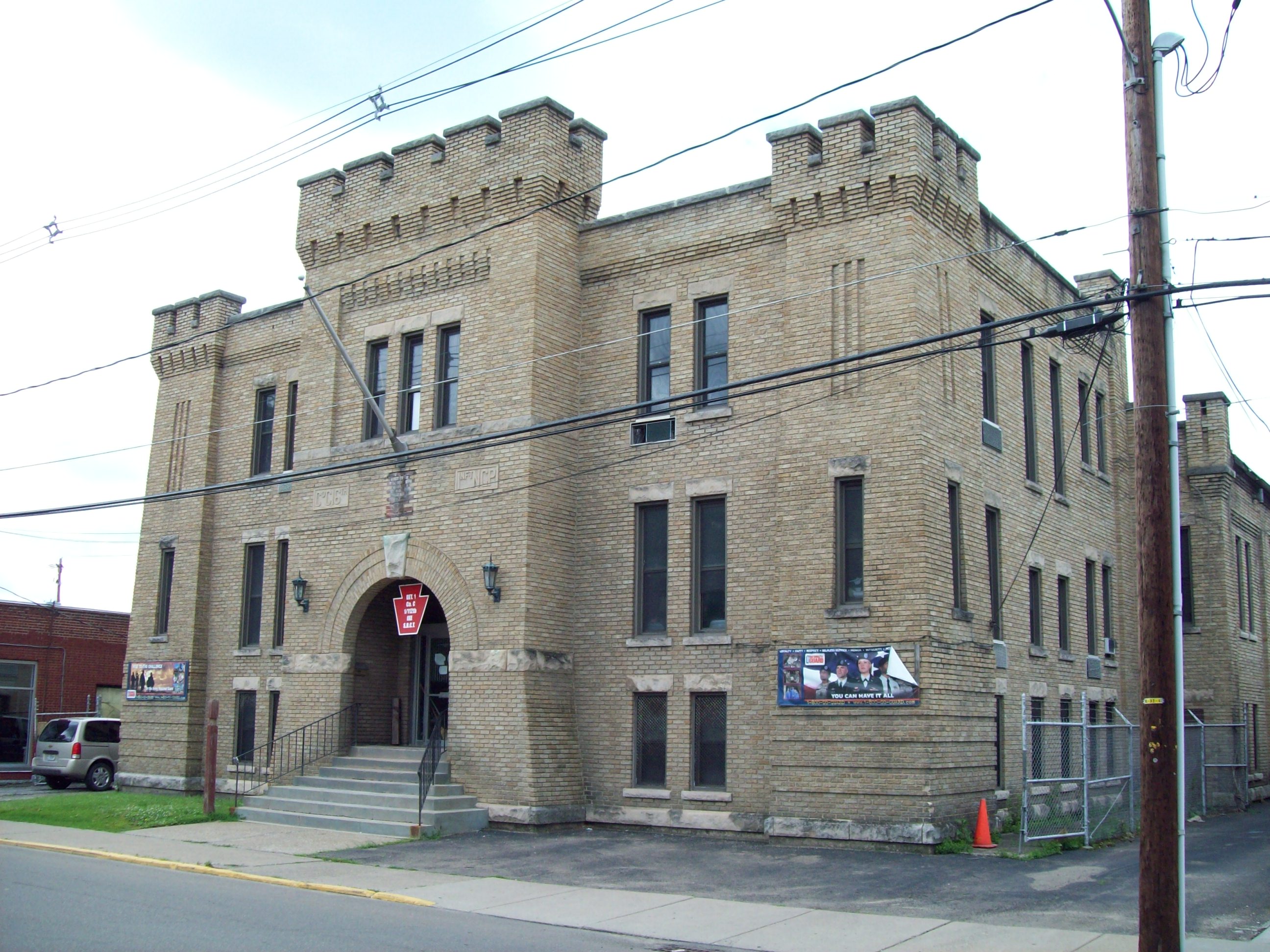
41°39′50″N 78°47′57″W / 41.66389°N 78.79917°WKane Georgian Colonial Revival style mansion constructed in 1896 for Dr. Elizabeth Dennistoun Wood Kane, wife of General Thomas L. Kane. 2 Bradford Armory 
May 9, 1991 28 Barbour Street
41°57′23″N 78°39′13″W / 41.95639°N 78.65361°WBradford Brick armory dating to 1912; part of the Multiple Property Submission for the Pennsylvania National Guard Armories. 3 Bradford Downtown Historic District 
August 31, 2000 Roughly bounded by Central Alley, Barbour Street, Bushnell Street, Howard Place, Davis Street, and Boylston Street.
41°57′20″N 78°39′2″W / 41.95556°N 78.65056°WBradford Features a number of 19th century Italianate style commercial structures. 4 Bradford Old City Hall 
May 17, 1976 Kennedy and Boylston Streets
41°57′24″N 78°38′50″W / 41.95667°N 78.64722°WBradford Eclectic Victorian city hall with four story clock tower. 5 Crook Farm 
March 26, 1976 Northeast of Bradford on Seaward Avenue
41°59′29″N 78°37′37″W / 41.99139°N 78.62694°WFoster Township Includes farmstead dating to 1856, and site of Olmstead Well. 6 Kane Armory 
May 9, 1991 Junction of Chestnut and Fraley Streets
41°39′28″N 78°48′42.5″W / 41.65778°N 78.811806°WKane Brick armory dating to 1922-1929; part of the Multiple Property Submission for the Pennsylvania National Guard Armories. 7 Thomas L. Kane Memorial Chapel 
March 29, 1978 30 Chestnut Street
41°39′27.5″N 78°48′31.5″W / 41.657639°N 78.80875°WKane Gothic Revival chapel constructed in 1876 and dedicated to General Thomas L. Kane. 8 Lynn Hall 
February 7, 2007 West side of U.S. Route 6, 1.5 miles (2.4 km) west of Port Allegany
41°49′36″N 78°18′26″W / 41.82667°N 78.30722°WLiberty Township Frank Lloyd Wright inspired restaurant and residence dating to 1935. 9 New Thomson House 
May 3, 1984 2 Greeves Street
41°39′32.5″N 78°48′39″W / 41.659028°N 78.81083°WKane Six story hotel constructed in 1907; now mixed use building. 10 Rufus Barrett Stone House 
November 14, 1982 11 Boylston Street
41°57′24″N 78°39′1″W / 41.95667°N 78.65028°WBradford Three story brick flatiron building constructed in 1903. Former listings
[3] Landmark name[4] Image Date delisted Location City or Town Summary 1 Kinzua Viaduct 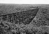
July 21, 2004 4.2 miles (6.8 km) northeast of Mount Jewett
41°45′45″N 78°35′18″W / 41.7625°N 78.58833°WHamlin and Keating Townships Collapsed in a windstorm on July 21, 2003. See also
- List of National Historic Landmarks in Pennsylvania
- National Register of Historic Places listings in Pennsylvania
- List of Pennsylvania state historical markers in McKean County
References
- ^ The latitude and longitude information provided in this table was derived originally from the National Register Information System, which has been found to be fairly accurate for about 99% of listings. For about 1% of NRIS original coordinates, experience has shown that one or both coordinates are typos or otherwise extremely far off; some corrections may have been made. A more subtle problem causes many locations to be off by up to 150 yards, depending on location in the country: most NRIS coordinates were derived from tracing out latitude and longitudes off of USGS topographical quadrant maps created under North American Datum of 1927, which differs from the current, highly accurate GPS system used by Google maps. Chicago is about right, but NRIS longitudes in Washington are higher by about 4.5 seconds, and are lower by about 2.0 seconds in Maine. Latitudes differ by about 1.0 second in Florida. Some locations in this table may have been corrected to current GPS standards.
- ^ "National Register of Historic Places: Weekly List Actions". National Park Service, United States Department of the Interior. Retrieved on November 10, 2011.
- ^ a b Numbers represent an ordering by significant words. Various colorings, defined here, differentiate National Historic Landmark sites and National Register of Historic Places Districts from other NRHP buildings, structures, sites or objects.
- ^ a b "NPS Focus". National Register of Historic Places. National Park Service. http://nrhp.focus.nps.gov. Retrieved November 20, 2009.
Municipalities and communities of McKean County, Pennsylvania County seat: Smethport City 
Boroughs Eldred | Kane | Lewis Run | Mount Jewett | Port Allegany | Smethport
Townships Unincorporated
communitiesBurning Well | Coryville | Cyclone | Farmers Valley | Gifford | Ludlow
Categories:- McKean County, Pennsylvania
- National Register of Historic Places in Pennsylvania by county
-


Wikimedia Foundation. 2010.