- National Register of Historic Places listings in Mille Lacs County, Minnesota
-
 Location of Mille Lacs County in Minnesota
This is a list of the National Register of Historic Places listings in Mille Lacs County, Minnesota. It is intended to be a complete list of the properties and districts on the National Register of Historic Places in Mille Lacs County, Minnesota, United States. The locations of National Register properties and districts for which the latitude and longitude coordinates are included below, may be seen in a Google map.[1]
There are 12 properties and districts listed on the National Register in the county, including 1 National Historic Landmark.
-
- This National Park Service list is complete through NPS recent listings posted November 10, 2011.[2]
Listings county-wide
[3] Landmark name [4] Image Date listed Location City or town Summary 1 Bridge No. 3355-Kathio Township June 29, 1998 U.S. Route 169 over Whitefish Creek
46°12′56″N 93°47′33″W / 46.215556°N 93.7925°WKathio Township 2 Cooper Site September 22, 1970 Address Restricted Onamia 3 Robert C. Dunn House 
August 29, 1985 708 S. 4th St.
45°33′57″N 93°35′03″W / 45.565833°N 93.584167°WPrinceton 4 Ephraim C. Gile House 
August 29, 1985 311 8th Ave., S.
45°33′57″N 93°35′06″W / 45.565833°N 93.585°WPrinceton 5 Great Northern Depot 
November 23, 1977 101 S 10th St.
45°34′09″N 93°35′16″W / 45.569167°N 93.587778°WPrinceton 6 Kathio Site 
October 15, 1966 Within Mille Lacs Kathio State Park Vineland 7 Milaca Municipal Hall 
September 11, 1985 145 Central Ave, S.
45°45′15″N 93°39′02″W / 45.754167°N 93.650556°WMilaca 8 Mille Lacs County Courthouse 
March 25, 1977 635 2nd St., SE.
45°45′16″N 93°38′34″W / 45.754444°N 93.642778°WMilaca 9 Onamia Municipal Hall 
September 10, 1985 Main and Birch Sts.
46°03′41″N 93°40′06″W / 46.061389°N 93.668333°WOnamia 10 Petaga Point September 22, 1970 Southern end of Ogechie Lake at the source of the Rum River
46°7′50.052″N 93°46′50.412″W / 46.13057°N 93.78067°W[5]Kathio Township 11 Saw Mill Site September 22, 1970 Address Restricted Onamia 12 Vineland Bay Site September 22, 1970 Address Restricted Vineland See also
- List of National Historic Landmarks in Minnesota
- National Register of Historic Places listings in Minnesota
References
- ^ The latitude and longitude information provided in this table was derived originally from the National Register Information System, which has been found to be fairly accurate for about 99% of listings. For about 1% of NRIS original coordinates, experience has shown that one or both coordinates are typos or otherwise extremely far off; some corrections may have been made. A more subtle problem causes many locations to be off by up to 150 yards, depending on location in the country: most NRIS coordinates were derived from tracing out latitude and longitudes off of USGS topographical quadrant maps created under the North American Datum of 1927, which differs from the current, highly accurate WGS84 GPS system used by Google maps. Chicago is about right, but NRIS longitudes in Washington are higher by about 4.5 seconds, and are lower by about 2.0 seconds in Maine. Latitudes differ by about 1.0 second in Florida. Some locations in this table may have been corrected to current GPS standards.
- ^ "National Register of Historic Places: Weekly List Actions". National Park Service, United States Department of the Interior. Retrieved on November 10, 2011.
- ^ Numbers represent an ordering by significant words. Various colorings, defined here, differentiate National Historic Landmark sites and National Register of Historic Places Districts from other NRHP buildings, structures, sites or objects.
- ^ "National Register Information System". National Register of Historic Places. National Park Service. . http://nrhp.focus.nps.gov/natreg/docs/All_Data.html.
- ^ Location derived from this state website; the NRIS lists the site as "Address Restricted"
U.S. National Register of Historic Places Topics Lists by states Alabama • Alaska • Arizona • Arkansas • California • Colorado • Connecticut • Delaware • Florida • Georgia • Hawaii • Idaho • Illinois • Indiana • Iowa • Kansas • Kentucky • Louisiana • Maine • Maryland • Massachusetts • Michigan • Minnesota • Mississippi • Missouri • Montana • Nebraska • Nevada • New Hampshire • New Jersey • New Mexico • New York • North Carolina • North Dakota • Ohio • Oklahoma • Oregon • Pennsylvania • Rhode Island • South Carolina • South Dakota • Tennessee • Texas • Utah • Vermont • Virginia • Washington • West Virginia • Wisconsin • WyomingLists by territories Lists by associated states Other Municipalities and communities of Mille Lacs County, Minnesota Cities 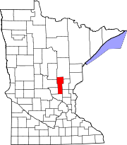
Townships CDP Indian
reservationFootnotes ‡This populated place also has portions in an adjacent county or counties
Categories:- National Register of Historic Places in Minnesota by county
- Mille Lacs County, Minnesota
- Buildings and structures in Mille Lacs County, Minnesota
-


Wikimedia Foundation. 2010.