- National Register of Historic Places listings in Montezuma County, Colorado
-
 Location of Montezuma County in Colorado
This is a list of the National Register of Historic Places listings in Montezuma County, Colorado. It is intended to be a complete list of the properties and districts on the National Register of Historic Places in Montezuma County, Colorado, United States. The locations of National Register properties and districts for which the latitude and longitude coordinates are included below, may be seen in a Google map.[1]
There are 31 properties and districts listed on the National Register in the county, including 2 National Historic Landmarks.
-
- This National Park Service list is complete through NPS recent listings posted November 10, 2011.[2]
Listings county-wide
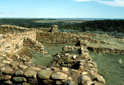
[3] Landmark name Image Date listed Location City or town Summary 1 Albert Porter Pueblo March 18, 1999 Address Restricted Yellow Jacket 2 Anasazi Archeological District July 19, 1984 Address Restricted Dolores 3 Archeological Site no. 5MT4700 June 11, 1999 Address Restricted Yellow Jacket 4 Bass Site June 11, 1999 Address Restricted Yellow Jacket 5 Bauer Bank Block October 11, 2003 107 W. Grand Ave.
37°20′42″N 108°17′20″W / 37.345°N 108.288889°WMancos 6 Cannonball Ruins April 30, 1997 Address Restricted Cortez 7 Ertel Funeral Home November 7, 1995 42 N. Market St.
37°20′58″N 108°35′03″W / 37.349444°N 108.584167°WCortez 8 Escalante Ruin November 20, 1975 Address Restricted Dolores 9 Hovenweep National Monument 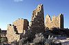
October 15, 1966 Northwest of Cortez
37°26′35″N 108°58′56″W / 37.443056°N 108.982222°WCortez 10 Joe Ben Wheat Site Complex January 16, 2004 Address Restricted Yellow Jacket 11 James A. Lancaster Site April 14, 1980 Address Restricted Pleasant View 12 Lebanon School May 29, 1996 24925 County Road T
37°27′28″N 108°35′29″W / 37.457778°N 108.591389°WDolores 13 Lost Canyon Archeological District October 18, 1988 Address Restricted Mancos 14 Lowry Ruin 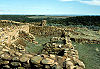
October 15, 1966 30 miles northwest of Cortez via U.S. Route 160 Pleasant View 15 Mancos High School December 23, 1991 350 Grand Ave.
37°20′44″N 108°17′32″W / 37.345556°N 108.292222°WMancos 16 Mancos Opera House January 7, 1988 136 W. Grand Ave.
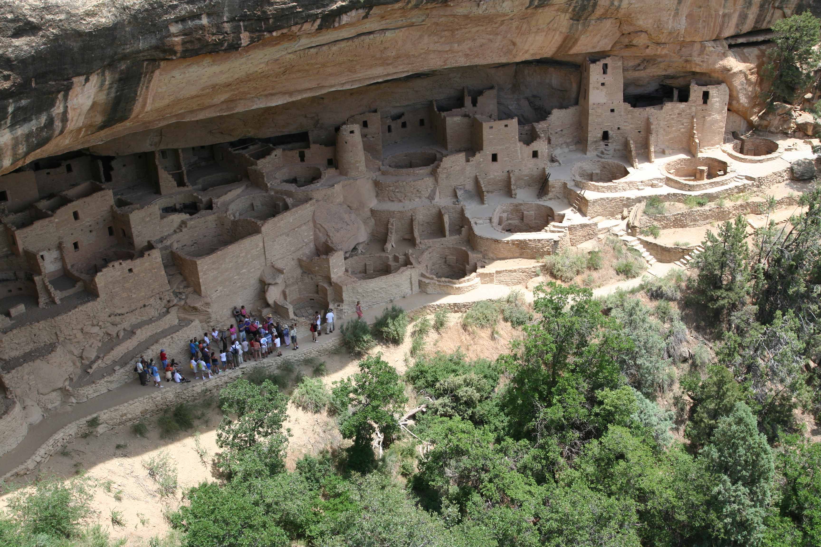
37°20′11″N 108°17′23″W / 37.336389°N 108.289722°WMancos 17 Mesa Verde Administrative District 
May 28, 1987 Area at head of Spruce Canyon off park service road
37°10′59″N 108°29′26″W / 37.183056°N 108.490556°WMesa Verde National Park 18 Mesa Verde National Park 
October 15, 1966 10 miles east of Cortez on U.S. Route 160 Cortez 19 Mitchell Springs Archeological Site November 9, 2001 7755 Road 25 Cortez 20 Montezuma Valley National Bank and Store Building January 15, 2009 2-8 Main St.
37°20′55″N 108°35′06″W / 37.34864°N 108.58502°WCortez 21 Mud Springs Pueblo October 29, 1982 Address Restricted Cortez 22 Pigge Site April 7, 1980 Address Restricted Pleasant View 23 Roy's Ruin January 31, 1992 Address Restricted Cortez 24 Sand Canyon Archaeological District March 15, 2005 Address Restricted Cortez 25 Seven Towers Pueblo June 11, 1999 Address Restricted Yellow Jacket 26 Southern Hotel February 23, 1989 101 S. 5th St.
37°28′35″N 108°30′09″W / 37.476389°N 108.5025°WDolores 27 Ute Mountain Ute Mancos Canyon Historic District May 2, 1972 Address Restricted Durango 28 Woods Canyon Pueblo June 11, 1999 Address Restricted Yellow Jacket 29 Wrightsman House February 14, 1997 209 Bauer Ave.
37°20′45″N 108°17′25″W / 37.345833°N 108.290278°WMancos 30 Yellowjacket Pueblo (5-MT-5) September 28, 1985 Address Restricted Yellow Jacket 31 Yucca House National Monument 
October 15, 1966 12 miles south of Cortez via U.S. Route 666
37°15′00″N 108°41′07″W / 37.25°N 108.685278°WCortez See also
- List of National Historic Landmarks in Colorado
- National Register of Historic Places listings in Colorado
References
- ^ The latitude and longitude information provided in this table was derived originally from the National Register Information System, which has been found to be fairly accurate for about 99% of listings. For about 1% of NRIS original coordinates, experience has shown that one or both coordinates are typos or otherwise extremely far off; some corrections may have been made. A more subtle problem causes many locations to be off by up to 150 yards, depending on location in the country: most NRIS coordinates were derived from tracing out latitude and longitudes off of USGS topographical quadrant maps created under North American Datum of 1927, which differs from the current, highly accurate GPS system used by Google maps. Chicago is about right, but NRIS longitudes in Washington are higher by about 4.5 seconds, and are lower by about 2.0 seconds in Maine. Latitudes differ by about 1.0 second in Florida. Some locations in this table may have been corrected to current GPS standards.
- ^ "National Register of Historic Places: Weekly List Actions". National Park Service, United States Department of the Interior. Retrieved on November 10, 2011.
- ^ Numbers represent an ordering by significant words. Various colorings, defined here, differentiate National Historic Landmark sites and National Register of Historic Places Districts from other NRHP buildings, structures, sites or objects.
U.S. National Register of Historic Places Topics Lists by states Alabama • Alaska • Arizona • Arkansas • California • Colorado • Connecticut • Delaware • Florida • Georgia • Hawaii • Idaho • Illinois • Indiana • Iowa • Kansas • Kentucky • Louisiana • Maine • Maryland • Massachusetts • Michigan • Minnesota • Mississippi • Missouri • Montana • Nebraska • Nevada • New Hampshire • New Jersey • New Mexico • New York • North Carolina • North Dakota • Ohio • Oklahoma • Oregon • Pennsylvania • Rhode Island • South Carolina • South Dakota • Tennessee • Texas • Utah • Vermont • Virginia • Washington • West Virginia • Wisconsin • WyomingLists by territories Lists by associated states Other Municipalities and communities of Montezuma County, Colorado City 
Towns CDP Unincorporated
communitiesIndian
reservationCategories:- National Register of Historic Places in Montezuma County, Colorado
- Montezuma County, Colorado
- National Register of Historic Places in Colorado by county
-


Wikimedia Foundation. 2010.