- National Register of Historic Places listings in Montrose County, Colorado
-
 Location of Montrose County in Colorado
This is a list of the National Register of Historic Places listings in Montrose County, Colorado. It is intended to be a complete list of the properties and districts on the National Register of Historic Places in Montrose County, Colorado, United States. The locations of National Register properties and districts for which the latitude and longitude coordinates are included below, may be seen in a Google map.[1]
There are 26 properties and districts listed on the National Register in the county.
-
- This National Park Service list is complete through NPS recent listings posted November 10, 2011.[2]
Listings county-wide
[3] Landmark name Image Date listed Location City or town Summary 1 Benevolent and Protective Order of Elks Lodge April 6, 2004 107 South Cascade Avenue
38°28′43″N 107°52′29″W / 38.478611°N 107.874722°WMontrose 2 D & RG Narrow Gauge Trestle 
June 18, 1976 Northeast of Cimarron
38°27′02″N 107°36′08″W / 38.450556°N 107.602222°WCimarron 3 Denver and Rio Grande Depot June 3, 1982 20 North Rio Grande Avenue
38°28′41″N 107°52′45″W / 38.478056°N 107.879167°WMontrose 4 Denver & Rio Grande Railroad Box Outfit Car No. 04414 
July 23, 2009 82800Q 83rd Road, Cimarron Visitor Center, Curecanti National Recreation Area (CURE)
38°26′31″N 107°33′19″W / 38.441931°N 107.555217°WCimarron 5 Denver & Rio Grande Western Railroad Boxcar No. 3132 
September 2, 2009 Approximately 1 mile (1.6 km) north by northeast of U.S. Route 50 at Cimarron, near Morrow Point Dam Road, Curecanti National Recreation Area
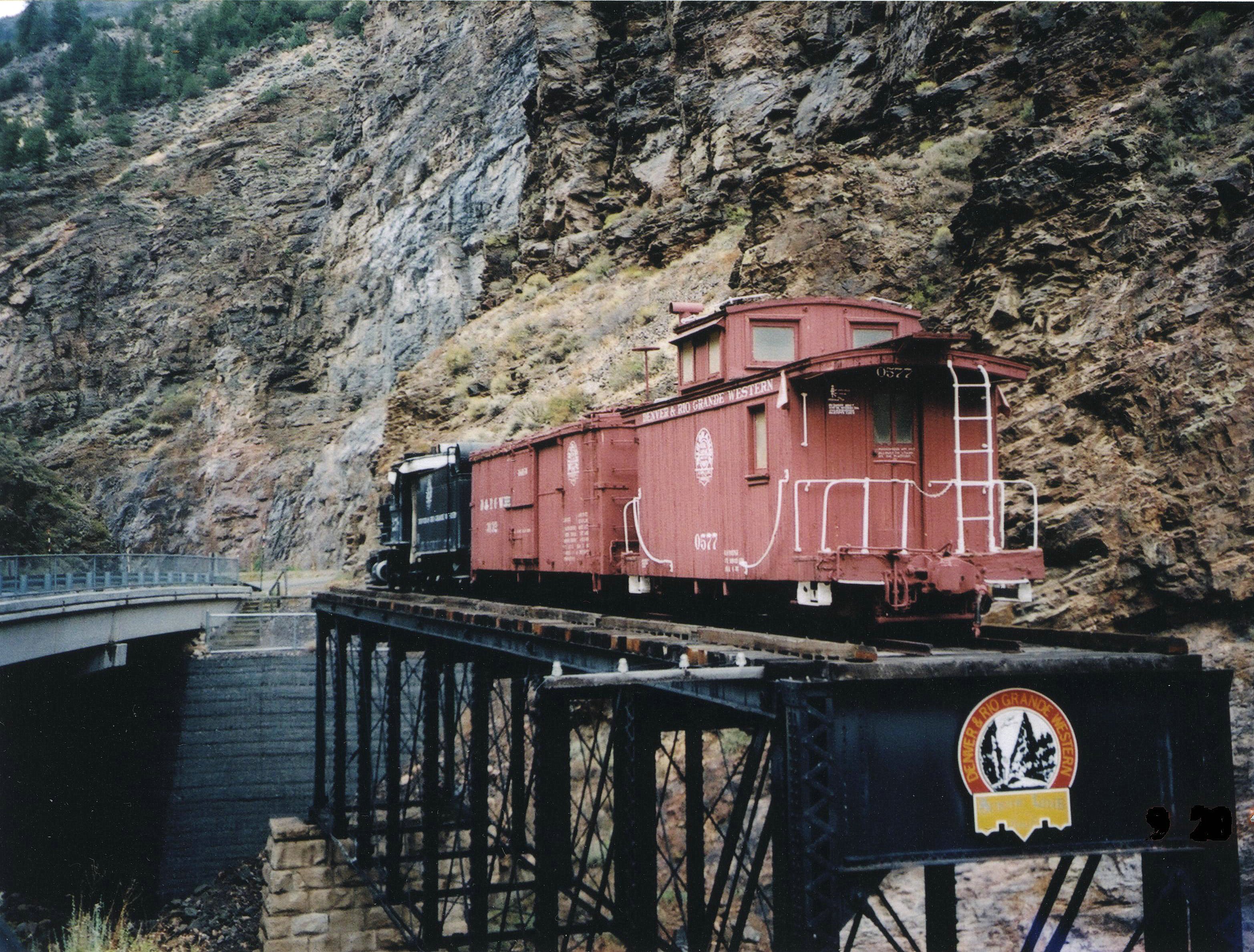
38°26′36″N 107°33′19″W / 38.443333°N 107.555278°WCimarron 6 Denver & Rio Grande Western Railroad Caboose No. 0577 
April 21, 2009 Approximately 1 mile (1.6 km) north by northeast of U.S. Route 50 at Cimarron, adjacent to Morrow Point Dam Road, Curecanti National Recreation Area
38°26′36″N 107°33′19″W / 38.443333°N 107.555278°WCimarron 7 Denver & Rio Grande Western Railroad Locomotive No. 278 and Tender 
April 21, 2009 Approximately 1 mile (1.6 km) north by northeast of U.S. Route 50 at Cimarron, adjacent to Morrow Point Dam Road, Curecanti National Recreation Area
38°26′36″N 107°33′19″W / 38.443333°N 107.555278°WCimarron 8 Denver & Rio Grande Western Railroad Stock Car No. 5620 January 27, 2010 82800Q 83rd Rd. at the Cimarron Visitor Center in the Curecanti National Recreation Area
38°26′36″N 107°33′19″W / 38.443333°N 107.555278°WCimarron 9 Denver & Rio Grande Western Railroad Stock Car No. 5679D January 27, 2010 82800Q 83rd Rd. at the Cimarron Visitor Center in the Curecanti National Recreation Area
38°26′36″N 107°33′19″W / 38.443333°N 107.555278°WCimarron 10 Dolores River Bridge 
October 15, 2002 State Highway 90 at milepost 15.22
38°18′38″N 108°53′09″W / 38.310556°N 108.885833°WBedrock 11 Gunnison Tunnel 
July 22, 1979 East of Montrose
38°29′55″N 107°40′38″W / 38.498611°N 107.677222°WMontrose Irrigation water tunnel, which, at time of completion in 1909, was longest such tunnel in the world 12 Hanging Flume 
May 15, 1980 5.7 miles (9.2 km) northwest of Uravan on State Highway 141
38°24′06″N 108°47′56″W / 38.401667°N 108.798889°WUravan 13 J. V. Lathrop House July 8, 1988 718 Main Street
38°28′55″N 107°52′19″W / 38.481944°N 107.871944°WMontrose 14 Methodist Episcopal Church of Montrose November 30, 1999 19 South Park Avenue
38°28′50″N 107°52′24″W / 38.480556°N 107.873333°WMontrose 15 Montrose City Hall June 3, 1982 433 South 1st Street
38°28′45″N 107°52′29″W / 38.479167°N 107.874722°WMontrose 16 Montrose County Courthouse February 18, 1994 320 South 1st Street
38°28′41″N 107°52′31″W / 38.478056°N 107.875278°WMontrose 17 Montrose Masonic Temple, Lodge No. 63 April 6, 2004 509–513 East Main Street
38°28′51″N 107°52′29″W / 38.480833°N 107.874722°WMontrose 18 North Rim Road, Black Canyon of the Gunnison National Park 
September 6, 2005 Black Canyon of the Gunnison National Park
38°34′23″N 107°41′28″W / 38.573056°N 107.691111°WCrawford 19 Rio Grande Southern Railroad Derrick Car May 10, 2010 82800Q 83rd Rd, Cimarron Visitor Center, Curecanti National Recreation Area
38°26′36″N 107°33′19″W / 38.443333°N 107.555278°WCimarron 20 Shavano Valley Rock Art Site October 12, 2001 Address Restricted Montrose 21 Sherman and Ross Block Building April 11, 2003 232–236 Main Street
38°28′42″N 107°52′38″W / 38.478333°N 107.877222°WMontrose 22 Silesca Ranger Station January 12, 2005 Grand Mesa in the Uncompahgre and Gunnison National Forests
38°19′56″N 108°07′29″W / 38.332222°N 108.124722°WGrand Mesa 23 Thomas B. Townsend House September 17, 1980 222 South 5th Street
38°28′28″N 107°52′23″W / 38.474444°N 107.873056°WMontrose 24 US Bureau of Reclamation Project Office Building November 27, 1991 601 North Park Avenue
38°29′08″N 107°52′43″W / 38.485556°N 107.878611°WMontrose 25 US Post Office-Montrose Main January 22, 1986 321 South 1st Street
38°28′44″N 107°52′36″W / 38.478889°N 107.876667°WMontrose 26 Ute Memorial Site February 26, 1970 2 miles (3.2 km) south of Montrose on U.S. Route 550
38°26′04″N 107°52′02″W / 38.434444°N 107.867222°WMontrose See also
- List of National Historic Landmarks in Colorado
- National Register of Historic Places listings in Colorado
References
- ^ The latitude and longitude information provided in this table was derived originally from the National Register Information System, which has been found to be fairly accurate for about 99% of listings. For about 1% of NRIS original coordinates, experience has shown that one or both coordinates are typos or otherwise extremely far off; some corrections may have been made. A more subtle problem causes many locations to be off by up to 150 yards, depending on location in the country: most NRIS coordinates were derived from tracing out latitude and longitudes off of USGS topographical quadrant maps created under the North American Datum of 1927, which differs from the current, highly accurate WGS84 GPS system used by Google maps. Chicago is about right, but NRIS longitudes in Washington are higher by about 4.5 seconds, and are lower by about 2.0 seconds in Maine. Latitudes differ by about 1.0 second in Florida. Some locations in this table may have been corrected to current GPS standards.
- ^ "National Register of Historic Places: Weekly List Actions". National Park Service, United States Department of the Interior. Retrieved on November 10, 2011.
- ^ Numbers represent an ordering by significant words. Various colorings, defined here, differentiate National Historic Landmark sites and National Register of Historic Places Districts from other NRHP buildings, structures, sites or objects.
U.S. National Register of Historic Places Topics Lists by states Alabama • Alaska • Arizona • Arkansas • California • Colorado • Connecticut • Delaware • Florida • Georgia • Hawaii • Idaho • Illinois • Indiana • Iowa • Kansas • Kentucky • Louisiana • Maine • Maryland • Massachusetts • Michigan • Minnesota • Mississippi • Missouri • Montana • Nebraska • Nevada • New Hampshire • New Jersey • New Mexico • New York • North Carolina • North Dakota • Ohio • Oklahoma • Oregon • Pennsylvania • Rhode Island • South Carolina • South Dakota • Tennessee • Texas • Utah • Vermont • Virginia • Washington • West Virginia • Wisconsin • WyomingLists by territories Lists by associated states Other Municipalities and communities of Montrose County, Colorado City 
Towns Unincorporated
communitiesGhost town Categories:- National Register of Historic Places in Colorado by county
- Montrose County, Colorado
-


Wikimedia Foundation. 2010.