- National Register of Historic Places listings in Morris County, New Jersey
-
List of the National Register of Historic Places listings in Morris County, New Jersey
Contents: Counties in New Jersey Atlantic - Bergen - Burlington - Camden - Cape May - Cumberland - Essex - Gloucester - Hudson - Hunterdon - Mercer - Middlesex - Monmouth - Morris - Ocean - Passaic - Salem - Somerset - Sussex - Union - Warren This is intended to be a complete list of properties and districts listed on the National Register of Historic Places in Morris County, New Jersey. The locations of National Register properties and districts (at least for all showing latitude and longitude coordinates below) may be seen in a Google map by clicking on "Map of all coordinates".[1]
-
- This National Park Service list is complete through NPS recent listings posted November 10, 2011.[2]
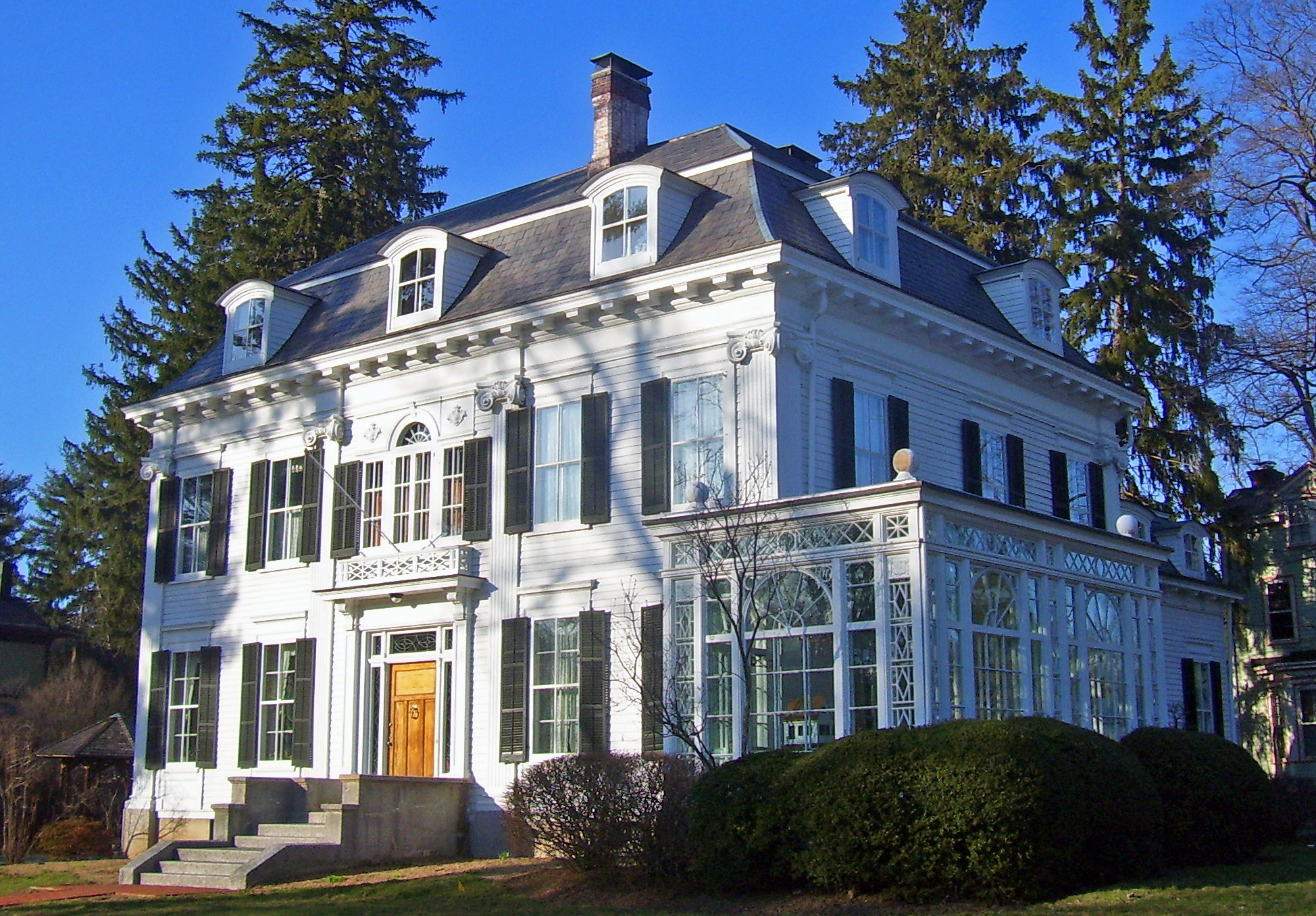
[3] Site name[4] Image Date listed Location[1] City or Town Summary 1 Acorn Hall April 3, 1973 68 Morris Ave.
40°47′48″N 74°27′38″W / 40.79667°N 74.46056°WMorristown 2 Alnwick Hall April 11, 1985 355 Madison Ave.
40°46′51″N 74°27′3″W / 40.78083°N 74.45083°WMorris Township 3 Anthony-Corwin Farm May 1, 1992 244 W. Mill Rd., Washington Township
40°46′14″N 74°48′19″W / 40.77056°N 74.80528°WLong Valley 4 Ayres' Farm May 29, 1998 25 Cooper Rd.
40°52′2″N 74°30′15″W / 40.86722°N 74.50417°WDenville 5 Baker Building July 1, 1981 16 W. Blackwell St. S4703
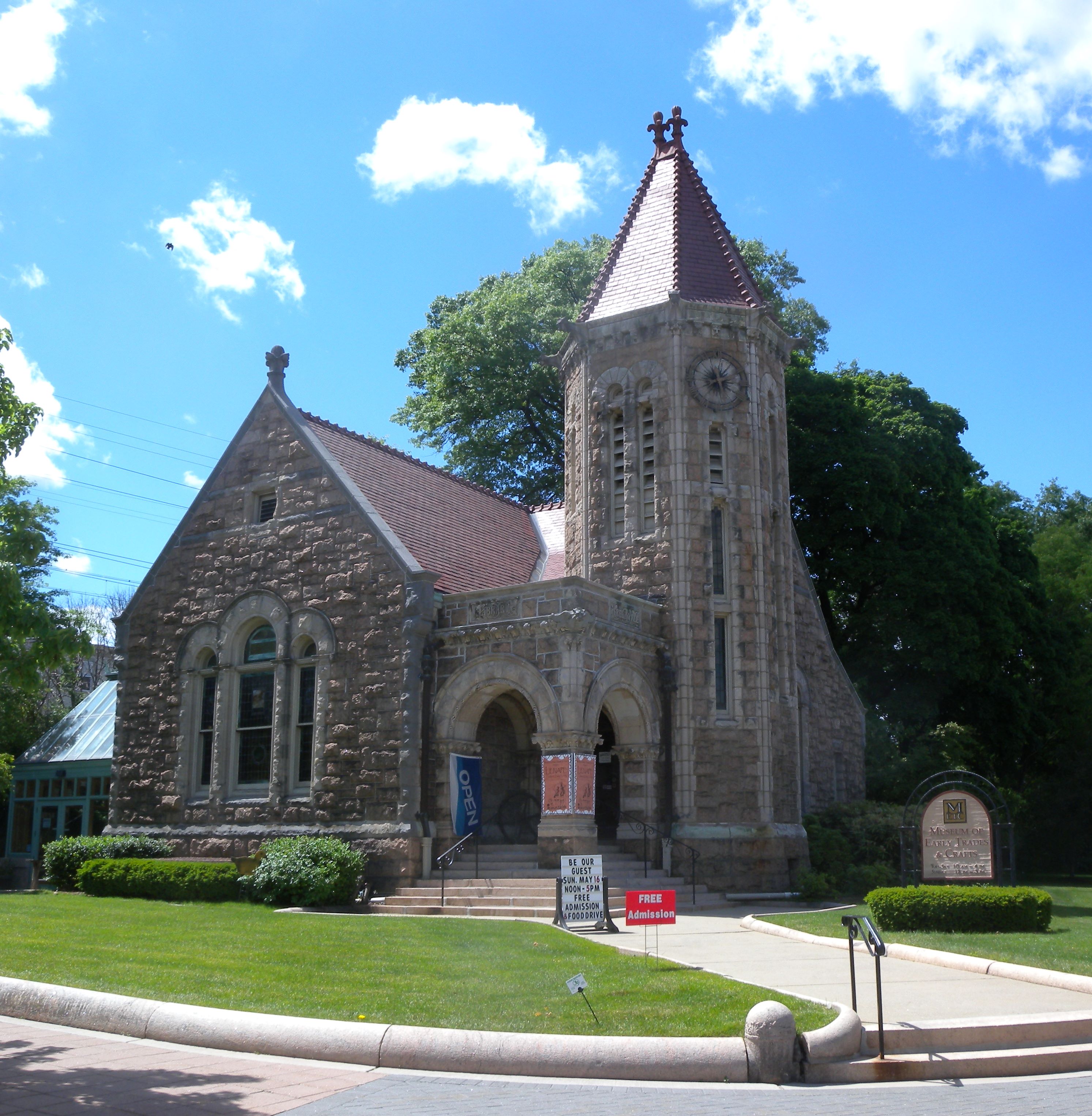
40°53′2″N 74°33′35″W / 40.88389°N 74.55972°WDover 6 Martin Berry House June 19, 1973 581 NJ 23 at Jackson Ave.
40°58′9″N 74°17′12″W / 40.96917°N 74.28667°WPompton Plains 7 Beverwyck Site May 14, 2004 SE of jct. of US 46 and S. Beverwyck Rd.
40°51′41″N 74°23′3″W / 40.86139°N 74.38417°WParsippany-Troy Hills 8 Blackwell Street Historic District May 21, 1982 Blackwell and Sussex Sts.
40°53′4″N 74°33′34″W / 40.88444°N 74.55944°WDover 9 Boisaubin Manor October 22, 1976 SE of Morristown on Treadwell Ave.
40°46′3″N 74°26′37″W / 40.7675°N 74.44361°WMorristown 10 Boonton Historic District September 29, 1980 Main, Church, Birch, Cornelia and Cedar Sts.
40°54′25″N 74°24′42″W / 40.90694°N 74.41167°WBoonton 11 Boonton Public Library November 13, 1972 619 Main St.
40°54′19″N 74°24′40″W / 40.90528°N 74.41111°WBoonton 12 Bottle Hill Historic District June 16, 2005 James Park, 1-105 Ridgedale ave.
40°45′57″N 74°24′54″W / 40.76583°N 74.415°WMadison 13 David S. Bower House November 30, 1982 427 Main St.
40°44′33″N 74°23′26″W / 40.7425°N 74.39056°WChatham 14 Bowers-Livingston-Osborn House June 19, 1973 25 Parsippany Rd.
40°51′53″N 74°25′36″W / 40.86472°N 74.42667°WParsippany 15 Bowlsby-Degelleke House December 15, 1978 NW of Parsippany at 320 Baldwin Rd.
40°52′7″N 74°23′46″W / 40.86861°N 74.39611°WParsippany 16 Boyle/Hudspeth-Benson House February 10, 1975 100 Basking Ridge Rd.
40°40′45.41″N 74°31′21.8″W / 40.6792806°N 74.522722°WMillington 17 Brookside February 16, 1996 Bounded by Tingley Rd., E. and W. Main Sts., Cold Hill Rd. and Cherry Ln., Mendham Township
40°47′34″N 74°34′4″W / 40.79278°N 74.56778°WBrookside 18 Dr. Jabez Campfield House September 4, 2008 5 Olyphant Pl.
40°47′49.59″N 74°28′21.02″W / 40.7971083°N 74.4725056°WMorristown 19 Lewis Carey Farmhouse July 20, 1977 208 Emmans Rd.
40°51′38″N 74°40′48″W / 40.86056°N 74.68°WFlanders 20 Cary Station September 5, 1985 239 Emmans Rd.
40°51′25″N 74°41′25″W / 40.85694°N 74.69028°WLedgewood 21 Stephen Cary House July 27, 1989 Mountainside Rd.
40°47′26″N 74°35′56″W / 40.79056°N 74.59889°WMendham 22 George Chamberlain House December 2, 2009 315 Dover-Milton Rd.
41°1′12.35″N 74°31′40.07″W / 41.0200972°N 74.5277972°WJefferson Twp. New listing; refnum 09000973 23 Chester House Inn July 18, 1974 Main St. and Hillside Rd.
40°47′11″N 74°41′43″W / 40.78639°N 74.69528°WChester 24 Combs Hollow February 16, 1996 Jct. of Combs Ave. and Combs Hollow Rd., S of Doby Rd., Randolph and Mendham Townships
40°48′33″N 74°36′55″W / 40.80917°N 74.61528°WMount Freedom 25 Community of St John Baptist April 24, 2007 82 W. Main St.
40°46′25.73″N 74°36′53.54″W / 40.7738139°N 74.6148722°WMendham 26 Dr. Lewis Condict House April 3, 1973 51 South St.
40°47′23″N 74°28′50″W / 40.78972°N 74.48056°WMorristown 27 Stephen Condit House February 15, 1974 NE of Parsippany on Beverwyck Rd. off U.S. 46
40°51′51″N 74°23′4″W / 40.86417°N 74.38444°WParsippany 28 Ellis Cook House May 12, 1975 174 Mount Pleasant Ave.
40°48′6″N 74°21′52″W / 40.80167°N 74.36444°WEast Hanover 29 Gen. Nathan Cooper Mansion December 29, 1978 W of Mendham on NJ 24
40°46′45″N 74°40′4″W / 40.77917°N 74.66778°WMendham 30 Nathan Cooper Gristmill November 21, 1976 W of Chester at Hacklebarney Rd. and NJ 24
40°46′44″N 74°43′20″W / 40.77889°N 74.72222°WChester 31 Craft-Clausen House May 1, 1992 170 Fairmont Rd., Washington Township
40°46′6″N 74°46′7″W / 40.76833°N 74.76861°WLong Valley 32 Craftsman Farms 
April 10, 1989 Jct. of NJ 10 and Manor Ln.
40°51′22″N 74°28′52″W / 40.85611°N 74.48111°WParsippany Home to Gustav Stickley and other artists and artisans of the Arts and Crafts Movement in the early 20th century 33 Cutler Homestead March 10, 1975 21 Cutler St.
40°48′28″N 74°29′4″W / 40.80778°N 74.48444°WMorristown 34 Davenport-Demarest House January 17, 1992 140 Changebridge Rd.
40°53′38″N 74°22′0″W / 40.89389°N 74.366667°WMontville 35 Decker-Kincaid Homestead March 9, 2005 591 Powerville Rd.
40°57′26″N 74°24′38″W / 40.95722°N 74.41056°WBoonton 36 Delaware, Lackawanna and Western Railroad Station 
March 11, 1980 132 Morris St.
40°47′50″N 74°28′29″W / 40.79722°N 74.47472°WMorristown 1913 Renaissance Revival station in use ever since. Some scenese from Cyndi Lauper's "Time After Time" video shot here. 37 Delaware, Lackawanna and Western Railroad Station July 13, 1977 Myrtle Ave., Main, and Division Sts.
40°54′14″N 74°24′23″W / 40.90389°N 74.40639°WBoonton 38 Delaware, Lackawanna and Western Railroad Station May 23, 1980 N. Dickerson St.
40°53′1″N 74°33′20″W / 40.88361°N 74.55556°WDover 39 James Dixon Farm August 29, 1977 NW of Boonton on Rockaway Valley Rd.
40°55′58″N 74°26′22″W / 40.93278°N 74.43944°WBoonton 40 John Dod House and Tavern August 12, 1977 11 Highland St. and 8 Chapel Hill Rd.
40°55′4″N 74°18′7″W / 40.91778°N 74.30194°WLincoln Park 41 Doremus House October 31, 1972 490 Main Rd.
40°55′11″N 74°21′16″W / 40.91972°N 74.35444°WTowaco 42 Dusenberry House 
November 1, 1979 186 Main St
40°44′23″N 74°22′50″W / 40.73972°N 74.38056°WChatham Mid-19th century home of local pastor 43 Fairmount Historic District December 20, 1996 Roughly, NJ 517 from the Morris-Hunterdon Co. line to NJ 512 and NJ 517 fron Fox Hill to Wildwood Rds.
40°43′8″N 74°46′34″W / 40.71889°N 74.77611°WCalifon 44 First Congregational Church August 10, 1977 Hillside Rd.
40°47′14″N 74°41′48″W / 40.78722°N 74.69667°WChester 45 First Presbyterian Church of Hanover November 10, 1977 Mount Pleasant and Hanover Aves.
40°48′13″N 74°22′7″W / 40.80361°N 74.36861°WEast Hanover 46 Flock-Stephens Farmstead May 1, 1992 244 Flocktown Rd., Washington Township
40°49′16″N 74°46′47″W / 40.82111°N 74.77972°WLong Valley 47 Flocktown Schoolhouse November 30, 1982 Flocktown and Naughright Rds.
40°48′57″N 74°47′13″W / 40.81583°N 74.78694°WLong Valley 48 Samuel Ford, Jr.'s, Hammock Farm December 23, 1974 310 Columbia Tpke.
40°47′26″N 74°24′36″W / 40.79056°N 74.41°WFlorham Park 49 Ford-Faesch House February 12, 1974 N of Dover at Mt. Hope Rd. and Mt. Hope Ave.
40°55′42″N 74°32′36″W / 40.92833°N 74.54333°WRockaway Township 50 Fordville November 2, 1978 E of Morristown at 30 Ford Hill Rd.
40°48′18″N 74°26′5″W / 40.805°N 74.43472°WMorristown 51 Fredericks House October 18, 1979 6 Duchess Dr.
40°58′27″N 74°22′3″W / 40.97417°N 74.3675°WFayson Lakes 52 Friends Meetinghouse June 4, 1973 S of Dover at Quaker Ave. and Quaker Church Rd., off NJ 18
40°51′54″N 74°34′11″W / 40.865°N 74.56972°WDover 53 German Valley Historic District July 14, 1983 NJ 24, Fairmount and Fairview Rds.
40°47′8″N 74°46′54″W / 40.78556°N 74.78167°WChester 54 Gibbons Mansion August 10, 1977 36 Madison Ave.
40°45′44″N 74°25′31″W / 40.76222°N 74.42528°WMadison 55 William Gibbons Stable and Farm March 30, 2005 Loantaka Way
40°44′55″N 74°26′42″W / 40.74861°N 74.445°WChatham Township 56 Glanville Blacksmith Shop March 25, 1987 47 Bank St.
40°47′43″N 74°29′1″W / 40.79528°N 74.48361°WMorristown 57 Glynallen March 9, 1987 Canfield Rd.
40°46′26″N 74°26′48″W / 40.77389°N 74.44667°WMorristown 58 Grimes Homestead April 1, 1977 45 Bloomfield Ave.
40°52′32″N 74°26′15″W / 40.87556°N 74.4375°WMountain Lakes 59 Rev. John Hancock House, Cider Mill and Cemetery August 30, 1984 45 Ridgedale Ave.
40°46′29″N 74°24′7″W / 40.77472°N 74.40194°WFlorham Park 60 Hanover Village Historic District September 13, 1993 Area surrounding Hanover Rd. and Mount Pleasant Ave., East Hanover Township
40°48′0″N 74°21′59″W / 40.8°N 74.36639°WEast Hanover 61 Hartley Farms July 19, 1991 Jct. of Spring Valley and Blue Mill Rds., Harding Twp.
40°45′16″N 74°27′38″W / 40.75444°N 74.46056°WMorristown 62 Benjamin Howell Homestead October 19, 1978 709 S. Beverwyck Rd.
40°50′49″N 74°23′33″W / 40.84694°N 74.3925°WParsippany 63 Illumination Gas Plant of the New Jersey State Asylum for the Insane at Morris Plains June 9, 2000 Old Dover Rd.
40°50′10″N 74°30′3″W / 40.83611°N 74.50083°WParsippany 64 Joseph Jackson House March 4, 1975 82 E. Main St.
40°53′56″N 74°30′36″W / 40.89889°N 74.51°WRockaway 65 Jenkins-Mead House March 10, 1997 14 Revere Rd.
40°47′22.79″N 74°28′10.46″W / 40.7896639°N 74.4695722°WMorristown 66 Peter Kemble House August 26, 1980 Old Camp Rd. and Mount Kemble Ave.
40°45′30″N 74°31′27″W / 40.75833°N 74.52417°WChatham 67 King Store and Homestead April 29, 1994 211 Main St., Roxbury Township
40°52′42″N 74°39′8″W / 40.87833°N 74.65222°WLedgewood 68 Lake Hopatcong Yacht Club 
August 12, 1999 N. Bertrand Rd. and Willow St.
40°55′42.51″N 74°38′59″W / 40.928475°N 74.64972°WMount Arlington 69 Lindenwold November 13, 1986 247 South St.
40°47′40″N 74°29′4″W / 40.79444°N 74.48444°WMorristown 70 Little Red Schoolhouse June 6, 1986 203 Ridgedale Ave.
40°47′17″N 74°23′26″W / 40.78806°N 74.39056°WFlorham Park 71 Effingham Low House January 17, 1992 102 Hook Mountain Rd., Montville Township
40°52′37″N 74°20′18″W / 40.87694°N 74.33833°WPine Brook 72 Madison Civic Commercial District 
October 18, 1991 Roughly Main St., Waverly Pl., Lincoln Pl., Prospect St., Kings Rd., Green Ave., Wilmer St., and Green Village Rd.
40°45′29″N 74°25′0″W / 40.75806°N 74.416667°WMadison Downtown core of Madison from late 19th century 73 Madison Masonic Lodge 
January 17, 2008 170 Main St.
40°45′25″N 74°24′31″W / 40.75694°N 74.40861°WMadison 74 Madison Public Library and the James Building 
February 8, 1980 Main St. and Green Village Rd.
40°45′35″N 74°25′3″W / 40.75972°N 74.4175°WMadison 75 Madison Station 
June 22, 1984 Kings Rd.
40°45′25″N 74°24′58″W / 40.75694°N 74.41611°WMadison 1916 stone Gothic Revival building 76 Mendham Historic District April 18, 1985 Roughly bounded by Halstead St. and Country Ln. on W. and E. Main St., Mountain Ave., Hilltop Rd. and Prospect St.
40°46′32″N 74°36′0″W / 40.77556°N 74.6°WMendham 77 Merchiston Farm November 13, 1989 Longview Rd.
40°43′46″N 74°42′28″W / 40.72944°N 74.70778°WChester 78 Methodist Episcopal Church May 2, 2008 24 Madison Ave.
40°45′48″N 74°25′22″W / 40.76333°N 74.42278°WMadison 79 Methodist Episcopal Church of Hibernia July 14, 2011 419 Green Pond Rd.
40°56′44″N 74°29′40″W / 40.94556°N 74.49444°WHibernia New listing; refnum 11000448 80 Middle Valley Historic District September 25, 1990 Along W. Mill Rd. and Middle Valley Rd. S of Beacon Rd.
40°45′29″N 74°49′1″W / 40.75806°N 74.81694°WLong Valley 81 Miller-Rinehard Farmstead February 1, 2006 72 Hacklebarney Rd.
40°45′18″N 74°44′40″W / 40.755°N 74.74444°WWashington Township 82 Miller-Kingsland House July 24, 1973 Vreeland Ave., 900 ft. W of Montville Township boundary
40°54′2″N 74°23′13″W / 40.90056°N 74.38694°WBoonton 83 Millington Station 
June 22, 1984 Long Hill Rd.
40°40′24″N 74°31′26″W / 40.67333°N 74.52389°WMillington 84 Timothy Mills House February 24, 1975 27 Mills St.
40°48′5″N 74°29′24″W / 40.80139°N 74.49°WMorristown 85 Montville Schoolhouse December 11, 2009 6 Taylortown
40°54′56.66″N 74°23′3.26″W / 40.9157389°N 74.3842389°WMontville New listing; refnum 09001075 86 Morris Canal October 1, 1974 Irregular line beginning at Phillipsburg and ending at Jersey City
40°41′8″N 75°9′49″W / 40.68556°N 75.16361°WNot Applicable 87 Morris County Courthouse 
August 19, 1977 Washington St. between Court St. and Western Ave.
40°47′51″N 74°29′5″W / 40.7975°N 74.48472°WMorristown 88 Morris Plains Station June 22, 1984 Speedwell Ave.
40°49′42″N 74°28′44″W / 40.82833°N 74.47889°WMorris Plains 89 Morristown and Erie Railroad Whippany Water Tank September 6, 2006 1 RR Plaza, NJ 10 W and Whippany Rd.
40°49′31″N 74°24′46″W / 40.82528°N 74.41278°WHanover Township 90 Morristown District October 30, 1973 Roughly bounded by the cemetery, King Pl., Madison and Colles Aves., DeHart St., and N. Park Pl.
40°47′38″N 74°28′51″W / 40.79389°N 74.48083°WMorristown Morristown Historic District boundary increase (listed 1986-11-13): Irregularly bounded by Lackawanna, Franklin Pl., James, Ogden Pl., Doughty, Mt. Kemble, Western, and Speedwell 91 Morristown National Historical Park October 15, 1966 At jct. of U.S. 202 and NJ 24
40°46′1″N 74°31′43″W / 40.76694°N 74.52861°WMorristown 92 Morristown School 
February 28, 1996 Jct. of Whippany Rd. and Hanover Ave., Morris Township
40°48′13″N 74°26′58″W / 40.80361°N 74.44944°WMorristown 93 Mott Hollow August 31, 1992 Roughly, Gristmill Rd. from Millbrook Ave. to Zandep Ln. and adjacent area along Millbrook, Randolph Township
40°51′43″N 74°33′7″W / 40.86194°N 74.55194°WMillbrook 94 Mount Arlington Historic District August 26, 1983 Howard Blvd., Edgemere and Windemere Aves.
40°55′56″N 74°37′58″W / 40.93222°N 74.63278°WMount Arlington 95 Mount Freedom Presbyterian Church October 11, 1991 Jct. of Sussex Tpk. and Church Rd., Randolph Township
40°49′38″N 74°34′56″W / 40.82722°N 74.58222°WMount Freedom 96 Mount Kemble Home November 13, 1986 1 Mt. Kemble Ave.
40°47′40″N 74°29′4″W / 40.79444°N 74.48444°WMorristown 97 Mountain Lakes Historic District September 7, 2005 Roughly bounded by Pocono Rd., Denville Township line, Fanny Rd., and RR Tracks
40°53′41″N 74°26′22″W / 40.89472°N 74.43944°WMountain Lakes 98 Thomas Nast Home 
October 15, 1966 MacCulloch Ave. and Miller Rd.
40°47′30″N 74°28′52″W / 40.79167°N 74.48111°WMorristown Home of influential political cartoonist Thomas Nast for much of his career 99 Jacob Wise (J. W.) Neighbor House February 22, 1991 143 W. Mill Rd., Washington Township
40°45′45″N 74°48′53″W / 40.7625°N 74.81472°WLong Valley 100 Leonard Neighbor Farmstead May 1, 1992 177 W. Mill Rd., Washington Township
40°46′15″N 74°47′24″W / 40.77083°N 74.79°WLong Valley 101 New Vernon Historic District July 8, 1982 Lee's Hill, Village, Mill Brook and Glen Alpin Rds.
40°44′36″N 74°29′57″W / 40.74333°N 74.49917°WHarding 102 New York Susquehanna & Western Railroad Station January 24, 2002 Main St.
41°0′14″N 74°20′33″W / 41.00389°N 74.3425°WButler 103 Normandy Park December 6, 1996 Normandy Pkway., between Columbia Tpk. and Madison Ave., Morris Township
40°47′31″N 74°27′10″W / 40.79194°N 74.45278°WMorristown 104 Oak Dell November 13, 1986 Franklin St. and Madison Ave.
40°47′20″N 74°27′37″W / 40.78889°N 74.46028°WMorristown 105 Our Lady of Mercy Chapel September 18, 1978 100 Whippany Rd.
40°49′11″N 74°25′1″W / 40.81972°N 74.41694°WWhippany 106 Palace Theatre May 24, 1996 7 Ledgewood Ave.
40°54′2″N 74°42′17″W / 40.90056°N 74.70472°WNetcong 107 Johannes Parlaman House January 17, 1992 15 Vreeland Ave.
40°54′3″N 74°22′50″W / 40.90083°N 74.38056°WMontville 108 Parsonage of the Montville Reformed Dutch Church January 17, 1992 107 Changebridge Rd.
40°54′0″N 74°21′54″W / 40.9°N 74.365°WMontville 109 Pompton Plains Railroad Station 
March 5, 2008 33 Evans Place
40°58′14″N 74°17′36″W / 40.97056°N 74.29333°WPequannock 110 Pottersville Village Historic District September 18, 1990 Properties fronting on Black River, Pottersville, McCann Mill and Hacklebarney Rds. and Fairmount Rd. E and Hill St.
40°42′52″N 74°43′21″W / 40.71444°N 74.7225°WPottersville 111 Pruddentown Historic District February 12, 2003 Mount Kemble Ave.
40°46′47″N 74°29′56″W / 40.77972°N 74.49889°WMorris Township 112 Ralston Historic District February 20, 1975 1 mi. W of Mendham at NJ 24 and Roxiticus Rd.
40°46′16″N 74°37′31″W / 40.77111°N 74.62528°WMendham Boundary increase (listed 1999-02-22): NJ 24 and Roxiticus Rd. 113 Rarick-Kellihan House May 1, 1992 358 Fairview Ave., Washington Township
40°48′56″N 74°45′8″W / 40.81556°N 74.75222°WLong Valley 114 Joseph W. Revere House September 20, 1973 NW of Morristown on Mendham Ave.
40°47′58″N 74°30′29″W / 40.79944°N 74.50806°WMorristown Fosterfields boundary increase (listed 1991-10-09): Jct. of Mendham and Kahdena Rds., Morris Township 115 Silas Riggs House November 11, 1977 217 Main St.
40°52′43″N 74°39′10″W / 40.87861°N 74.65278°WLedgewood 116 Alfred T. Ringling Manor June 3, 1976 S of Oak Ridge on Berkshire Valley Rd.
41°0′33″N 74°31′0″W / 41.00917°N 74.516667°WOak Ridge 117 Rockaway Valley Methodist Church November 11, 1977 NW of Boonton
40°55′42″N 74°26′12″W / 40.92833°N 74.43667°WBoonton 118 Sayre House February 12, 1980 31 Ridgedale Ave.
40°45′44″N 74°24′58″W / 40.76222°N 74.41611°WMadison 119 Schooley's Mountain Historic District June 14, 1991 Roughly along Schooley's Mt. Rd., Pleasant Grove Rd. and Flocktown Rd., Washington Twp.
40°48′8″N 74°49′7″W / 40.80222°N 74.81861°WSchooley's Mountain 120 Sharpenstine Farmstead May 1, 1992 98 E. Mill Rd., Washington Township
40°47′8″N 74°45′47″W / 40.78556°N 74.76306°WLong Valley 121 Silver Lake Historic District March 5, 1999 Roughly along Blue Mill Rd., Dickson's Mill Rd., Beuren Rd., Red Gate Rd., and James St.
40°45′8″N 74°28′22″W / 40.75222°N 74.47278°WHarding 122 Slater's Mill June 18, 1975 96 Paterson-Hamburg Tpke.
40°59′55″N 74°18′22″W / 40.99861°N 74.30611°WRiverdale 123 Bridget Smith House February 27, 1998 124 Randolph Ave.
40°52′25″N 74°35′49″W / 40.87361°N 74.59694°WMine Hill Township 124 John Smith House January 1, 1976 Washington Valley Rd.
40°48′20″N 74°31′37″W / 40.80556°N 74.52694°WMorristown 125 Speedwell Village-The Factory 
September 13, 1974 333 Speedwell Ave.
40°47′50″N 74°28′51″W / 40.79722°N 74.48083°WMorristown 126 Split Rock Furnace November 6, 1974 NW of Boonton
40°57′33″N 74°27′43″W / 40.95917°N 74.46194°WRockaway Township 127 Spring Brook House November 13, 1986 167 James St.
40°46′56″N 74°28′59″W / 40.78222°N 74.48306°WMorristown 128 Tempe Wick Road-Washington Corners Historic District August 25, 2000 Corey Ln., Cemetery Rd., Tempe Wick, Kennaday, Leddell, and Jockey Hollow Rds.
40°45′56″N 74°33′30″W / 40.76556°N 74.55833°WHarding 129 David Thompson House July 24, 1973 56 W. Main St.
40°46′26″N 74°36′45″W / 40.77389°N 74.6125°WMendham 130 Thorne and Eddy Estates December 14, 1978 E of Morristown on Columbia Rd.
40°47′42″N 74°26′40″W / 40.795°N 74.44444°WMorristown 131 Trimmer-Dufford Farmstead May 1, 1992 186 W. Mill Rd., Washington Township
40°46′24″N 74°47′48″W / 40.77333°N 74.79667°WLong Valley 132 Tuttle House October 5, 1977 341 NJ 10
40°49′12″N 74°24′26″W / 40.82°N 74.40722°WWhippany 133 David Tuttle Cooperage June 19, 1979 83 Gristmill Rd.
40°51′35″N 74°33′21″W / 40.85972°N 74.55583°WDover 134 United States Army Steam Locomotive No. 4039 March 4, 2002 1 Railroad Plaza, 10 West and Whippany Rd.
40°49′23″N 74°24′41″W / 40.82306°N 74.41139°WHanover Township 135 James Van Duyne Farm House April 15, 1982 32 Waughaw Rd.
40°55′32″N 74°20′54″W / 40.92556°N 74.34833°WTowaco 136 Martin Van Duyne House January 17, 1992 292 Main Rd.
40°54′59″N 74°22′15″W / 40.91639°N 74.37083°WMontville 137 Simon Van Duyne House January 17, 1992 58 Maple Ave., Montville Township
40°51′55″N 74°20′22″W / 40.86528°N 74.33944°WPine Brook 138 Van Duyne-Jacobus House January 17, 1992 29 Changebridge Rd.
40°54′39″N 74°21′50″W / 40.91083°N 74.36389°WMontville 139 Vanness – Linen House July 14, 2011 211 Hamburg Turnpike
41°0′3″N 74°18′54″W / 41.00083°N 74.315°WRiverdale New listing; refnum 11000449 140 Nicholas Vreeland Outkitchen December 11, 2009 52 Jacksonville Rd.
40°55′59.38″N 74°20′32.98″W / 40.9331611°N 74.3424944°WTowaco New listing; refnum 09001076 141 Washington Valley Historic District November 12, 1992 Roughly bounded by Schoolhouse, Gaston, Sussex, Kahdena, Mendham, Tingley and Washington Valley
40°47′39″N 74°31′47″W / 40.79417°N 74.52972°WMorristown 142 Washington Valley Schoolhouse October 15, 1973 Washington Valley Rd. and Schoolhouse Lane
40°48′22″N 74°31′52″W / 40.80611°N 74.53111°WWashington Valley 143 Whippany Burying Yard December 11, 2009 New Jersey Route 10
40°49′9″N 74°24′22″W / 40.81917°N 74.40611°WHanover New listing; refnum 09001077 144 Whippany Farm September 22, 1977 53 E. Hanover Ave.
40°48′5″N 74°27′10″W / 40.80139°N 74.45278°WMorristown 145 Willow Hall January 18, 2011 330 Speedwell Avenue
40°48′51″N 74°29′0″W / 40.81417°N 74.483333°WMorristown New listing; refnum 10001146 References
- ^ a b The latitude and longitude information provided in this table was derived originally from the National Register Information System, which has been found to be fairly accurate for about 99% of listings. For about 1% of NRIS original coordinates, experience has shown that one or both coordinates are typos or otherwise extremely far off; some corrections may have been made. A more subtle problem causes many locations to be off by up to 150 yards, depending on location in the country: most NRIS coordinates were derived from tracing out latitude and longitudes off of USGS topographical quadrant maps created under North American Datum of 1927, which differs from the current, highly accurate GPS system used by Google maps. Chicago is about right, but NRIS longitudes in Washington are higher by about 4.5 seconds, and are lower by about 2.0 seconds in Maine. Latitudes differ by about 1.0 second in Florida. Some locations in this table may have been corrected to current GPS standards.
- ^ "National Register of Historic Places: Weekly List Actions". National Park Service, United States Department of the Interior. Retrieved on November 10, 2011.
- ^ Numbers represent an ordering by significant words. Various colorings, defined here, differentiate National Historic Landmark sites, a [[National Historic Site (United States)|]], and several National Register of Historic Places Districts from other NRHP buildings, structures, sites or objects.
- ^ "National Register Information System". National Register of Historic Places. National Park Service. 2008-04-24. http://nrhp.focus.nps.gov/natreg/docs/All_Data.html.
U.S. National Register of Historic Places Topics Lists by states Alabama • Alaska • Arizona • Arkansas • California • Colorado • Connecticut • Delaware • Florida • Georgia • Hawaii • Idaho • Illinois • Indiana • Iowa • Kansas • Kentucky • Louisiana • Maine • Maryland • Massachusetts • Michigan • Minnesota • Mississippi • Missouri • Montana • Nebraska • Nevada • New Hampshire • New Jersey • New Mexico • New York • North Carolina • North Dakota • Ohio • Oklahoma • Oregon • Pennsylvania • Rhode Island • South Carolina • South Dakota • Tennessee • Texas • Utah • Vermont • Virginia • Washington • West Virginia • Wisconsin • WyomingLists by territories Lists by associated states Other  Category:National Register of Historic Places •
  Portal:National Register of Historic Places
 State of New Jersey
Trenton (capital) Topics Delegations · Demographics · Economy · Elections · Geography · Government · History · Media · Municipalities · Music · People · Politics · Symbols · Transportation · Parks
Regions Atlantic Coastal Plain · Central Jersey · Delaware River Region · Delaware Valley · Gateway Region · Gold Coast · Highlands · Jersey Shore · Meadowlands · New York metro area · North Hudson · North Jersey · Pascack Valley · Piedmont · Pine Barrens · Raritan Bayshore · Ridge-and-Valley Appalachians · Southern Shore Region · Skylands Region · South Jersey · Tri‑State Region · West Hudson
Counties Major cities Atlantic City · Camden · Edison · Elizabeth · Hackensack · Jersey City · Newark · New Brunswick · Ocean City · Paterson · Trenton · Vineland
Categories:- National Register of Historic Places in New Jersey
- Morris County, New Jersey
-


Wikimedia Foundation. 2010.