- National Register of Historic Places listings in Morrow County, Ohio
-
 Location of Morrow County in Ohio
This is a list of the National Register of Historic Places listings in Morrow County, Ohio.
This is intended to be a complete list of the properties and districts on the National Register of Historic Places in Morrow County, Ohio, United States. The locations of National Register properties and districts for which the latitude and longitude coordinates are included below, may be seen in a Google map.[1]
There are 15 properties and districts listed on the National Register in the county. Another property was once listed but has been removed.
-
- This National Park Service list is complete through NPS recent listings posted November 10, 2011.[2]
Current listings
[3] Landmark name [4] Image Date listed Location City or town Summary 1 Reuben Benedict House 
May 8, 2000 1463 County Road 24, west of Marengo
40°24′29″N 82°51′48″W / 40.408056°N 82.863333°WPeru Township 2 Samuel P. Brown House 
March 15, 1982 South of Fulton on Worthington-New Haven Rd.
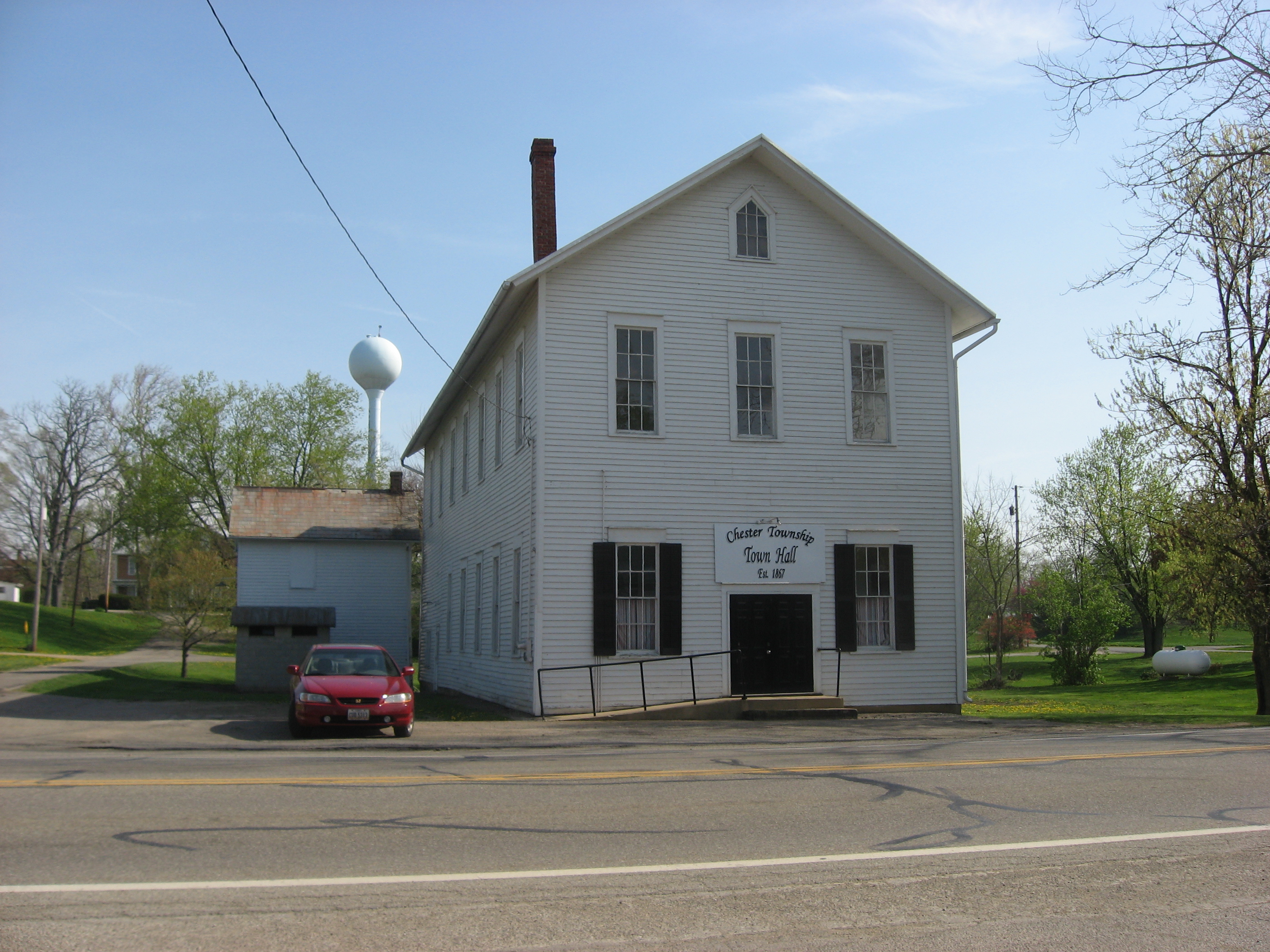
40°26′31″N 82°50′48″W / 40.441944°N 82.846667°WLincoln Township 3 Chester Town Hall 
August 21, 1979 Sandusky and Short Sts.
40°28′48″N 82°40′57″W / 40.48°N 82.6825°WChesterville 4 Chesterville Methodist Church 
August 21, 1979 Sandusky and East Sts.
40°28′46″N 82°40′54″W / 40.479444°N 82.681667°WChesterville 5 Floral Hall 
December 12, 1976 Morrow County Fairgrounds
40°32′39″N 82°49′52″W / 40.544167°N 82.831111°WMount Gilead 6 Jarvis House 
August 21, 1979 77 S. Portland St.
40°28′44″N 82°41′00″W / 40.478889°N 82.683333°WChesterville 7 Levering Hall 
May 29, 1980 12 S. Main St.
40°32′55″N 82°49′41″W / 40.548611°N 82.828056°WMount Gilead 8 Enos Miles House 
August 21, 1979 154 S. Portland St.
40°28′41″N 82°41′02″W / 40.478056°N 82.683889°WChesterville 9 Morrow County Courthouse and Jail 
July 25, 1974 Courthouse Sq.
40°32′57″N 82°49′35″W / 40.549167°N 82.826389°WMount Gilead 10 Old Bartlett and Goble Store 
August 21, 1979 Sandusky and Portland Sts.
40°28′47″N 82°41′00″W / 40.479722°N 82.683333°WChesterville 11 Old Union School 
August 21, 1979 63 E. Denmon Ave.
40°28′51″N 82°40′56″W / 40.480833°N 82.682222°WChesterville 12 A.B. Sears House 
August 21, 1979 52 W. Sandusky St.
40°28′49″N 82°41′07″W / 40.480278°N 82.685278°WChesterville 13 James S. Trimble House 
November 30, 1982 187 Iberia St.
40°33′07″N 82°50′02″W / 40.551944°N 82.833889°WMount Gilead 14 U.S. Post Office 
August 21, 1979 44 E. Sandusky St.
40°28′46″N 82°40′58″W / 40.479444°N 82.682778°WChesterville 15 Wood Commercial Building 
August 21, 1979 Sandusky and Portland Sts.
40°28′47″N 82°41′01″W / 40.479722°N 82.683611°WChesterville Former listing
[3] Landmark name Image Date listed Location City or town Summary 1 Exchange Hotel May 5, 1983 W. Main St. Cardington Listed in 1979 See also
References
- ^ The latitude and longitude information provided in this table was derived originally from the National Register Information System, which has been found to be fairly accurate for about 99% of listings. For about 1% of NRIS original coordinates, experience has shown that one or both coordinates are typos or otherwise extremely far off; some corrections may have been made. A more subtle problem causes many locations to be off by up to 150 yards, depending on location in the country: most NRIS coordinates were derived from tracing out latitude and longitudes off of USGS topographical quadrant maps created under the North American Datum of 1927, which differs from the current, highly accurate WGS84 GPS system used by Google maps. Chicago is about right, but NRIS longitudes in Washington are higher by about 4.5 seconds, and are lower by about 2.0 seconds in Maine. Latitudes differ by about 1.0 second in Florida. Some locations in this table may have been corrected to current GPS standards.
- ^ "National Register of Historic Places: Weekly List Actions". National Park Service, United States Department of the Interior. Retrieved on November 10, 2011.
- ^ a b Numbers represent an ordering by significant words. Various colorings, defined here, differentiate National Historic Landmark sites and National Register of Historic Places Districts from other NRHP buildings, structures, sites or objects.
- ^ "National Register Information System". National Register of Historic Places. National Park Service. . http://nrhp.focus.nps.gov/natreg/docs/All_Data.html.
National Register of Historic Places in Ohio Lists by county Adams • Allen • Ashland • Ashtabula • Athens • Auglaize • Belmont • Brown • Butler • Carroll • Champaign • Clark • Clermont • Clinton • Columbiana • Coshocton • Crawford • Cuyahoga • Darke • Defiance • Delaware • Erie • Fairfield • Fayette • Franklin • Fulton • Gallia • Geauga • Greene • Guernsey • Hamilton • Hancock • Hardin • Harrison • Henry • Highland • Hocking • Holmes • Huron • Jackson • Jefferson • Knox • Lake • Lawrence • Licking • Logan • Lorain • Lucas • Madison • Mahoning • Marion • Medina • Meigs • Mercer • Miami • Monroe • Montgomery • Morgan • Morrow • Muskingum • Noble • Ottawa • Paulding • Perry • Pickaway • Pike • Portage • Preble • Putnam • Richland • Ross • Sandusky • Scioto • Seneca • Shelby • Stark • Summit • Trumbull • Tuscarawas • Union • Van Wert • Vinton • Warren • Washington • Wayne • Williams • Wood • Wyandot
Lists by city Other lists Municipalities and communities of Morrow County, Ohio City 
Villages Cardington | Chesterville | Edison | Fulton | Marengo | Mount Gilead | Sparta
Townships Bennington | Canaan | Cardington | Chester | Congress | Franklin | Gilead | Harmony | Lincoln | North Bloomfield | Perry | Peru | South Bloomfield | Troy | Washington | Westfield
Unincorporated
communitiesFootnotes ‡This populated place also has portions in an adjacent county or counties
Categories:- National Register of Historic Places in Ohio by county
- Morrow County, Ohio
-


Wikimedia Foundation. 2010.