- National Register of Historic Places listings in Navajo County, Arizona
-
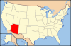
 Location of Navajo County in Arizona
This is a list of the National Register of Historic Places listings in Navajo County, Arizona. It is intended to be a complete list of the properties and districts on the National Register of Historic Places in Navajo County, Arizona, United States. The locations of National Register properties and districts for which the latitude and longitude coordinates are included below, may be seen in a Google map.[1]
There are 55 properties and districts listed on the National Register in the county, including 2 that are also National Historic Landmarks.
-
- This National Park Service list is complete through NPS recent listings posted November 10, 2011.[2]
Current listings
[3] Landmark name Image Date listed Location City or town Summary 1 Agate House Pueblo 
October 6, 1975 Petrified Forest National Park
34°48′18″N 109°51′40″W / 34.805°N 109.861111°WHolbrook 2 Arizona Rancho October 17, 1997 Junction of Tovar and Apache Sts.
34°53′58″N 110°09′39″W / 34.899444°N 110.160833°WHolbrook 3 Awatovi Ruins 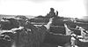
October 15, 1966 West of Jeddito
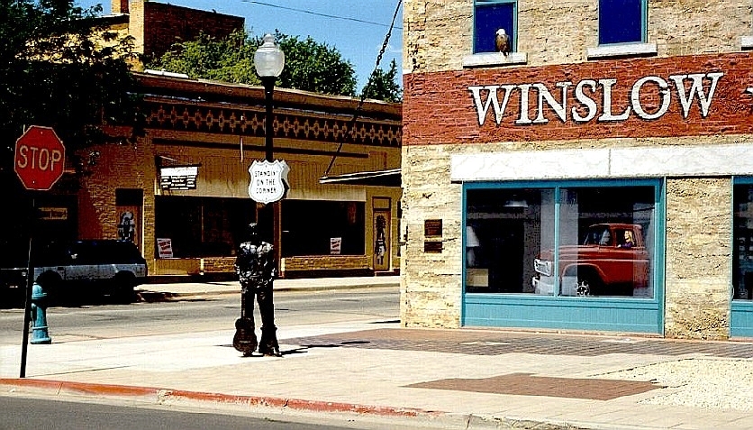
35°43′07″N 110°16′37″W / 35.718611°N 110.276944°WKeams Canyon 4 Bacavi (Paaqavi) Historic District December 6, 1996 Address Restricted Bacavi 5 Bailey Ruin March 17, 2006 Address Restricted Pinedale 6 Baird's Chevelon Steps January 23, 2003 Address Restricted Winslow 7 Brigham City June 9, 1978 North of Winslow
35°2′30″N 110°39′2″W / 35.04167°N 110.65056°W[4]Winslow 8 Norman Brimhall House March 10, 2004 210 S. Main St.
34°27′41″N 110°05′27″W / 34.461389°N 110.090833°WTaylor 9 Cedar Canyon Bridge 
September 30, 1988 U.S. Route 60 over Cedar Canyon at milepost 323.4
34°03′32″N 110°12′33″W / 34.058889°N 110.209167°WShow Low 10 Chevelon Creek Bridge December 8, 1983 Chevelon Creek, southeast of Winslow
34°55′24″N 110°31′43″W / 34.923333°N 110.528611°WWinslow 11 Chevelon Ruin March 1, 1984 Address Restricted Winslow 12 Corduroy Creek Bridge 
September 30, 1988 U.S. Route 60 over Corduroy Creek at milepost 328.3
34°06′24″N 110°09′10″W / 34.106667°N 110.152778°WShow Low 13 Deer Springs Lookout Complex January 28, 1988 Apache-Sitgreaves National Forest
34°18′23″N 110°25′13″W / 34.306389°N 110.420278°WMogollon Rim 14 Abner Ellsworth House April 25, 1997 260 N. 8th St.
34°15′08″N 110°02′00″W / 34.252222°N 110.033333°WShow Low 15 James M. Flake House July 14, 1971 Stinson and Hunt Sts.
34°30′39″N 110°04′31″W / 34.510833°N 110.075278°WSnowflake 16 Fort Apache Historic District October 14, 1976 South of Whiteriver off State Route 73 on the Fort Apache Indian Reservation
33°47′25″N 109°59′16″W / 33.790278°N 109.987778°WWhiteriver 17 John A. Freeman House November 25, 1980 Main and Freeman Sts.
34°30′39″N 110°04′43″W / 34.510833°N 110.078611°WSnowflake 18 Grasshopper Ruin February 17, 1978 Address Restricted Cibecue 19 Holbrook Bridge (U.S. Route 70) September 30, 1988 Abandoned grade of U.S. Route 70 over the Little Colorado River, 4.2 miles southeast of Holbrook
34°53′06″N 110°06′35″W / 34.885°N 110.109722°WHolbrook A Luten Arch bridge from 1916 20 Holbrook Bridge (State Route 77) 
March 31, 1989 State Route 77 over the Little Colorado River
34°53′52″N 110°09′43″W / 34.897778°N 110.161944°WHolbrook A Warren pony truss bridge from 1928 21 Homolovi Four (IV) June 4, 1986 Address Restricted Winslow 22 Homolovi I Ruin June 4, 1984 Address Restricted Winslow 23 Homolovi II August 2, 1983 Address Restricted Winslow 24 Homolovi III March 1, 1984 Address Restricted Winslow 25 Lorenzo Hubbell Trading Post and Warehouse November 21, 2002 523 W. 2nd St.
35°01′36″N 110°42′12″W / 35.026667°N 110.703333°WWinslow 26 John R. Hulet House March 25, 1980 Hulet Ave. and Smith St.
34°30′34″N 110°04′55″W / 34.509444°N 110.081944°WSnowflake 27 Inscription Rock April 6, 1978 East of Keams Canyon off State Route 264
35°48′44″N 110°10′06″W / 35.812222°N 110.168333°WKeams Canyon 28 Jack's Canyon Bridge September 30, 1988 Abandoned State Route 99 over Jack's Canyon southeast of Winslow
34°58′32″N 110°39′11″W / 34.975556°N 110.653056°WWinslow 29 La Posada Historic District March 31, 1992 200 E. 2nd St.
35°01′18″N 110°41′41″W / 35.021667°N 110.694722°WWinslow 30 Lithodendron Wash Bridge September 30, 1988 13.2 miles northeast of Holbrook on Interstate 40 Frontage Rd.
34°59′30″N 109°56′59″W / 34.991667°N 109.949722°WHolbrook 31 Little Lithodendron Wash Bridge September 30, 1988 15.8 miles northeast of Holbrook on Interstate 40 Frontage Rd.
34°59′27″N 109°54′27″W / 34.990833°N 109.9075°WHolbrook 32 Lower Cibecue Lutheran Mission March 5, 2002 Fort Apache Indian Reservation
34°01′14″N 110°28′52″W / 34.020556°N 110.481111°WCibecue 33 Navajo County Courthouse 
July 31, 1978 Courthouse Sq.
34°54′12″N 110°09′24″W / 34.903333°N 110.156667°WHolbrook 34 Old Oraibi 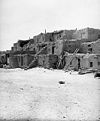
October 15, 1966 Hopi Indian Reservation
35°52′37″N 110°38′17″W / 35.876944°N 110.638056°WOraibi 35 Painted Desert Petroglyphs and Ruins Archeological District June 24, 1976 Address Restricted Holbrook 36 A. Z. Palmer House March 10, 2004 26 E. Center
34°27′55″N 110°05′21″W / 34.465278°N 110.089167°WTaylor 37 Jordan Palmer House March 10, 2004 101 S. Main St.
34°27′48″N 110°05′25″W / 34.463333°N 110.090278°WTaylor 38 Pinedale Elementary School March 8, 2002 300 S. Main St.
34°18′16″N 110°14′14″W / 34.304444°N 110.237222°WPinedale 39 Pinedale Ranger Station June 10, 1993 Forest Rd. 130 (formerly State Route 260) in the Apache-Sitgreaves National Forest
34°03′44″N 110°14′54″W / 34.062222°N 110.248333°WPinedale 40 St. Joseph Bridge September 30, 1988 4.4 miles southeast of Joseph City on Joseph City-Holbrook Rd.
34°56′28″N 110°19′23″W / 34.941111°N 110.323056°WJoseph City 41 Sidney Sapp House March 13, 1986 215 W. Hopi
34°53′58″N 110°10′03″W / 34.899444°N 110.1675°WHolbrook 42 Shumway School January 29, 1979 Off State Route 77
34°24′23″N 110°04′21″W / 34.406389°N 110.0725°WShumway 43 Jesse N. Smith House July 14, 1971 203 W. Smith Ave.
34°30′29″N 110°04′49″W / 34.508056°N 110.080278°WSnowflake 44 Snowflake Stake Academy Building March 25, 1980 Ballard and Hulet Aves.
34°30′27″N 110°04′56″W / 34.5075°N 110.082222°WSnowflake 45 Snowflake Townsite Historic District March 26, 1998 Roughly bounded by 3rd St. N., Stinson, 2nd St. S., and Hulet
34°30′33″N 110°04′43″W / 34.509167°N 110.078611°WSnowflake 46 South Central Avenue Commercial Historic District February 14, 1997 119 S. Central Ave.
34°53′59″N 110°09′26″W / 34.899722°N 110.157222°WHolbrook 47 Aquilla Standifird House March 10, 2004 306 S. Main St.
34°27′38″N 110°05′27″W / 34.460556°N 110.090833°WTaylor 48 Standing Fall House November 1, 1985 Address Restricted Black Mesa 49 Stinson-Flake House March 10, 1982 Freeman Ave and Stinson St.
34°30′39″N 110°04′37″W / 34.510833°N 110.076944°WSnowflake 50 Wigwam Village No. 6 
May 2, 2002 811 W. Hopi Dr.
34°54′08″N 110°10′06″W / 34.902222°N 110.168333°WHolbrook 51 Winslow Bridge March 31, 1989 State Route 87 over the Little Colorado River at milepost 344.9
35°00′24″N 110°39′18″W / 35.006667°N 110.655°WWinslow 52 Winslow Commercial Historic District 
April 20, 1989 Roughly bounded by 3rd, Williamson Ave., 1st, and Warren Ave.
35°01′24″N 110°41′50″W / 35.023333°N 110.697222°WWinslow 53 Winslow Residential Historic District April 28, 1989 Kinsley Ave. from Oak to Aspinwall
35°01′35″N 110°41′44″W / 35.026389°N 110.695556°WWinslow 54 Winslow Underpass September 30, 1988 State Route 87 under the ATSF railroad line at milepost 342.1
35°01′17″N 110°39′17″W / 35.021389°N 110.654722°WWinslow 55 Woodruff Bridge September 30, 1988 4 miles south of Woodruff on Woodruff-Snowflake Rd.
34°44′22″N 110°02′12″W / 34.739444°N 110.036667°WWoodruff See also
- List of National Historic Landmarks in Arizona
- National Register of Historic Places listings in Arizona
References
- ^ The latitude and longitude information provided in this table was derived originally from the National Register Information System, which has been found to be fairly accurate for about 99% of listings. For about 1% of NRIS original coordinates, experience has shown that one or both coordinates are typos or otherwise extremely far off; some corrections may have been made. A more subtle problem causes many locations to be off by up to 150 yards, depending on location in the country: most NRIS coordinates were derived from tracing out latitude and longitudes off of USGS topographical quadrant maps created under the North American Datum of 1927, which differs from the current, highly accurate WGS84 GPS system used by Google maps. Chicago is about right, but NRIS longitudes in Washington are higher by about 4.5 seconds, and are lower by about 2.0 seconds in Maine. Latitudes differ by about 1.0 second in Florida. Some locations in this table may have been corrected to current GPS standards.
- ^ "National Register of Historic Places: Weekly List Actions". National Park Service, United States Department of the Interior. Retrieved on November 10, 2011.
- ^ Numbers represent an ordering by significant words. Various colorings, defined here, differentiate National Historic Landmark sites and National Register of Historic Places Districts from other NRHP buildings, structures, sites or objects.
- ^ Coordinates derived from its GNIS feature record; the NRIS provides the location but no coordinates
U.S. National Register of Historic Places Topics Lists by states Alabama • Alaska • Arizona • Arkansas • California • Colorado • Connecticut • Delaware • Florida • Georgia • Hawaii • Idaho • Illinois • Indiana • Iowa • Kansas • Kentucky • Louisiana • Maine • Maryland • Massachusetts • Michigan • Minnesota • Mississippi • Missouri • Montana • Nebraska • Nevada • New Hampshire • New Jersey • New Mexico • New York • North Carolina • North Dakota • Ohio • Oklahoma • Oregon • Pennsylvania • Rhode Island • South Carolina • South Dakota • Tennessee • Texas • Utah • Vermont • Virginia • Washington • West Virginia • Wisconsin • WyomingLists by territories Lists by associated states Other Properties on the National Register of Historic Places in Arizona 
Municipalities and communities of Navajo County, Arizona Cities 
Towns CDPs Chilchinbito | Cibecue | Dilkon | East Fork | First Mesa | Greasewood | Heber-Overgaard | Hotevilla-Bacavi | Jeddito | Kayenta | Keams Canyon | Kykotsmovi Village | McNary‡ | Oljato-Monument Valley | Pinon | Second Mesa | Shongopovi | Shonto | Whiteriver | Winslow West‡
Unincorporated
communitiesClay Springs | Fort Apache | Indian Wells | Joseph City | Linden | Oraibi | Pinedale | Polacca | Sun Valley | White Mountain Lakes Estates | Woodruff
Ghost towns Brigham City | Sunset
Footnotes ‡This populated place also has portions in an adjacent county or counties
Categories:- National Register of Historic Places in Arizona by county
- Navajo County, Arizona
- History of Navajo County, Arizona
-


Wikimedia Foundation. 2010.