- National Register of Historic Places listings in Nelson County, Kentucky
-
 Location of Nelson County in Kentucky
This is a list of the National Register of Historic Places listings in Nelson County, Kentucky. It is intended to be a complete list of the properties and districts on the National Register of Historic Places in Nelson County, Kentucky, United States. The locations of National Register properties and districts for which the latitude and longitude coordinates are included below, may be seen in a Google map.[1]
There are approximately 40 properties and districts listed on the National Register in the county.
-
- This National Park Service list is complete through NPS recent listings posted November 10, 2011.[2]
Listings county-wide
[3] Landmark name Image Date listed Location City or town Summary 1 Archeological Site 15 Ne 3 September 27, 1979 Address Restricted Lenore 2 Baldwin's Tourist Court Residence-Office November 10, 2011 321 W. Stephen Foster Ave.
37°48′37″N 85°28′18″W / 37.810144°N 85.471642°WBardstown 3 Bardstown Historic District 
February 17, 1983 Roughly bounded by 1st, 3rd (U.S. 31E/150), and 5th Sts., Muir Ave., and railroad track
37°48′40″N 85°27′57″W / 37.81111°N 85.46583°W
Boundary increase (listed November 10, 2010): Generally bounded by First St., Fifth St., Muir Ave., Beall Ave., Maiden's Alley, Cherry Alley, Mulberry AlleyBardstown 4 Beechwold November 29, 1984 500 E. Stephen Foster Ave. (U.S. 62/150)
37°48′32″N 85°27′14″W / 37.808889°N 85.453889°WBardstown 5 Bloomfield Historic District March 18, 1991 Central Bloomfield, including parts of Hill, Main, Perry, and Depot Sts. and Fairfield, Springfield, and Taylorsville Roads
37°54′43″N 85°19′09″W / 37.911944°N 85.319167°WBloomfield 6 Bruntwood September 9, 1975 714 N. 3rd St. (U.S. 31E/150)
37°49′15″N 85°27′50″W / 37.820833°N 85.463889°WBardstown 7 Cobblestone Path 
November 16, 1989 Eastern end of Flaget Ave., northeastern to Broadway
37°48′36″N 85°27′46″W / 37.81°N 85.462778°WBardstown 8 Confederate Monument of Bardstown 
July 17, 1997 North Bardstown Cemetery, 0.3 miles south of the junction of U.S. Routes 31E/150 and 208
37°49′28″N 85°27′42″W / 37.824444°N 85.461667°WBardstown 9 Coombs-Duncan-Brown Farmhouse August 5, 2010 2985 Chaplin-Taylorsville Rd.
37°56′11″N 85°16′53″W / 37.936389°N 85.281389°WBloomfield vicinity 10 Cottage Grove Historic District April 18, 1991 1015 Old Bloomfield Pike
37°49′06″N 85°27′07″W / 37.818333°N 85.451944°WBardstown 11 Culpeper May 26, 1988 Northern side of Springfield Rd./U.S. Route 150
37°47′59″N 85°26′23″W / 37.799722°N 85.439722°WBardstown 12 Henry Duncan House December 6, 1990 Taylorsville Rd. north of Maple Grove Cemetery
37°55′06″N 85°19′01″W / 37.918333°N 85.316944°WBloomfield 13 Edgewood 
July 30, 1975 310 S. 5th St.
37°48′21″N 85°28′17″W / 37.805833°N 85.471389°WBardstown 14 Frankfort and Cincinnati Model 55 Rail Car October 8, 1998 136 S. Main St.
37°39′22″N 85°35′34″W / 37.656111°N 85.592778°WNew Haven 15 Howard Brothers' Store October 16, 1986 General Delivery
37°34′21″N 85°35′32″W / 37.5725°N 85.592222°WHowardstown 16 Ben Johnson House 
July 16, 1979 1003 N. 3rd St. (U.S. 31E/150)
37°49′41″N 85°27′38″W / 37.828056°N 85.460556°WBardstown 17 Silvester Johnson House and Business 
April 12, 2002 151-153 N. Main St.
37°39′31″N 85°35′36″W / 37.658611°N 85.593333°WNew Haven 18 John S. Kelley House March 6, 1992 306 S. 5th St.
37°48′24″N 85°28′18″W / 37.806667°N 85.471667°WBardstown 19 L & N Steam Locomotive No. 152 December 30, 1974 Junction of Depot and 1st Sts.
37°39′25″N 85°35′31″W / 37.656944°N 85.591944°WNew Haven 20 Louisville and Nashville Combine Car Number 665 November 19, 1997 136 S. Main St.
37°39′25″N 85°35′33″W / 37.656944°N 85.5925°WNew Haven 21 Mattingly House January 8, 1987 Off U.S. Route 150
37°48′27″N 85°25′27″W / 37.8075°N 85.424167°WBardstown 22 Newell B. McClaskey House March 24, 2000 1795 KY 1066
37°55′24″N 85°16′16″W / 37.923333°N 85.271111°WBloomfield 23 MT. BRODERICK Pullman Lounge-Obs-Sleeping Car November 18, 1997 136 S. Main St.
37°39′22″N 85°35′34″W / 37.656111°N 85.592778°WNew Haven 24 My Old Kentucky Home 
March 11, 1971 U.S. Route 150, Stephen Foster Ave.
37°48′02″N 85°27′24″W / 37.800556°N 85.456667°WBardstown 25 Nelson County Jail 
January 8, 1987 111 W. Stephen Foster St.
37°48′33″N 85°28′03″W / 37.809167°N 85.4675°WBardstown 26 New Sherwood Hotel 
March 26, 1992 138 S. Main St.
37°39′26″N 85°35′37″W / 37.657222°N 85.593611°WNew Haven 27 Old Kentucky Home Motel November 10, 2011 414 W. Stephen Foster Ave.
37°48′38″N 85°28′25″W / 37.810572°N 85.473556°WBardstown 28 Old L & N Station 
July 12, 1990 602 N. 3rd St. (U.S. 31E/150)
37°48′52″N 85°27′54″W / 37.814444°N 85.465°WBardstown 29 Old Talbott Tavern 
October 30, 1973 Court Sq.
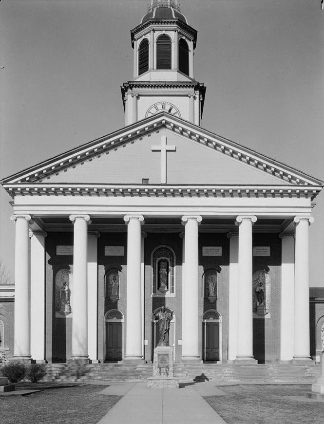
37°48′32″N 85°28′03″W / 37.808889°N 85.4675°WBardstown 30 St. Joseph Cathedral and College Complex 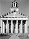
June 3, 1976 W. Stephen Foster Ave.
37°48′39″N 85°28′15″W / 37.810833°N 85.470833°WBardstown 31 St. Joseph Proto Cathedral 
January 9, 1974 W. Stephen Foster Ave.
37°48′39″N 85°28′17″W / 37.810833°N 85.471389°WBardstown 32 St. Thomas Roman Catholic Church and Howard-Flaget House 
July 12, 1976 3 miles south of Bardstown off U.S. Route 31E
37°46′00″N 85°29′01″W / 37.766667°N 85.483611°WBardstown 33 T. W. Samuels Distillery Historic District November 1, 1988 Junction of KY 523 and Corman Railroad tracks
37°54′00″N 85°33′31″W / 37.9°N 85.558611°WDeatsville 34 Sisters of Charity of Nazareth Historic District March 15, 1984 North of Bardstown off U.S. Route 31E/150
37°50′59″N 85°28′22″W / 37.849722°N 85.472778°WBardstown 35 Spalding Hall, St. Joseph's College 
May 7, 1973 N. 5th St.
37°48′41″N 85°28′16″W / 37.811389°N 85.471111°WBardstown 36 Stone House on Buffalo Creek August 18, 1983 Off KY 1330
37°50′29″N 85°31′11″W / 37.841389°N 85.519722°WBardstown 37 John Stone House July 12, 1984 U.S. Route 62
37°54′11″N 85°18′45″W / 37.903056°N 85.3125°WBloomfield 38 Walnut Groves Farm April 1, 1980 North of Bloomfield on KY 55; also 801 Taylorsville Rd.
37°55′24″N 85°19′15″W / 37.923333°N 85.320833°WBloomfield Taylorsville Road address represents a boundary increase 39 Wickland 
February 16, 1973 0.5 miles east of Bardstown on U.S. Route 62
37°48′49″N 85°27′08″W / 37.813611°N 85.452222°WBardstown 40 Wilson Motel November 10, 2011 530 N. 3rd St.
37°48′56″N 85°27′53″W / 37.815667°N 85.464736°WBardstown See also
- List of National Historic Landmarks in Kentucky
- National Register of Historic Places listings in Kentucky
References
- ^ The latitude and longitude information provided in this table was derived originally from the National Register Information System, which has been found to be fairly accurate for about 99% of listings. For about 1% of NRIS original coordinates, experience has shown that one or both coordinates are typos or otherwise extremely far off; some corrections may have been made. A more subtle problem causes many locations to be off by up to 150 yards, depending on location in the country: most NRIS coordinates were derived from tracing out latitude and longitudes off of USGS topographical quadrant maps created under the North American Datum of 1927, which differs from the current, highly accurate WGS84 GPS system used by Google maps. Chicago is about right, but NRIS longitudes in Washington are higher by about 4.5 seconds, and are lower by about 2.0 seconds in Maine. Latitudes differ by about 1.0 second in Florida. Some locations in this table may have been corrected to current GPS standards.
- ^ "National Register of Historic Places: Weekly List Actions". National Park Service, United States Department of the Interior. Retrieved on November 10, 2011.
- ^ Numbers represent an ordering by significant words. Various colorings, defined here, differentiate National Historic Landmark sites and National Register of Historic Places Districts from other NRHP buildings, structures, sites or objects.
U.S. National Register of Historic Places Topics Lists by states Alabama • Alaska • Arizona • Arkansas • California • Colorado • Connecticut • Delaware • Florida • Georgia • Hawaii • Idaho • Illinois • Indiana • Iowa • Kansas • Kentucky • Louisiana • Maine • Maryland • Massachusetts • Michigan • Minnesota • Mississippi • Missouri • Montana • Nebraska • Nevada • New Hampshire • New Jersey • New Mexico • New York • North Carolina • North Dakota • Ohio • Oklahoma • Oregon • Pennsylvania • Rhode Island • South Carolina • South Dakota • Tennessee • Texas • Utah • Vermont • Virginia • Washington • West Virginia • Wisconsin • WyomingLists by territories Lists by associated states Other Municipalities and communities of Nelson County, Kentucky Cities 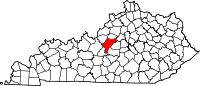
Unincorporated
communityCategories:- National Register of Historic Places in Kentucky by county
- Nelson County, Kentucky
-


Wikimedia Foundation. 2010.