- National Register of Historic Places listings in Noble County, Ohio
-
 Location of Noble County in Ohio
This is a list of the National Register of Historic Places listings in Noble County, Ohio.
This is intended to be a complete list of the properties and districts on the National Register of Historic Places in Noble County, Ohio, United States. The locations of National Register properties and districts for which the latitude and longitude coordinates are included below, may be seen in a Google map.[1]
There are 9 properties and districts listed on the National Register in the county.
-
- This National Park Service list is complete through NPS recent listings posted November 10, 2011.[2]
Current listings
[3] Landmark name [4] Image Date listed Location City or town Summary 1 Samuel Caldwell House 
March 11, 1980 East and Locust Sts.
39°44′40″N 81°30′47″W / 39.744444°N 81.513056°WCaldwell 2 Samuel Danford Farm, Church and Cemetery 
March 27, 1980 North of Summerfield on County Road 5-A
39°51′31″N 81°20′56″W / 39.858611°N 81.348889°WMarion Township 3 Huffman Covered Bridge March 4, 1975 1.5 miles south of Middleburg off State Route 564
39°39′37″N 81°22′13″W / 39.660278°N 81.370278°WJefferson Township Destroyed 4 Noble County Jail and Sheriff's Office 
February 20, 2004 419 West St.
39°44′50″N 81°31′01″W / 39.747222°N 81.516944°WCaldwell 5 St. Henry Roman Catholic Church and Rectory December 2, 1982 36573 County Road 47 at Harriettsville
39°37′46″N 81°20′18″W / 39.629444°N 81.338333°WElk Township 6 St. Mary's Church of the Immaculate Conception July 21, 1980 Off State Route 564 at Fulda
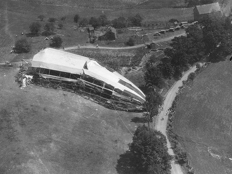
39°43′27″N 81°24′55″W / 39.724167°N 81.415278°WEnoch Township 7 SHENANDOAH Crash Sites 
July 25, 1989 Near Interstate 77 and County Road 37 (near Ava), and State Route 78 west of Caldwell Noble and Sharon Townships 8 Abner Williams Log House 
June 20, 1979 Northeast of Lashley
39°56′46″N 81°21′38″W / 39.946111°N 81.360556°WWayne Township 9 Young-Shaw House 
February 8, 1980 East of Sarahsville on State Route 146
39°48′10″N 81°25′57″W / 39.802778°N 81.4325°WCenter Township See also
References
- ^ The latitude and longitude information provided in this table was derived originally from the National Register Information System, which has been found to be fairly accurate for about 99% of listings. For about 1% of NRIS original coordinates, experience has shown that one or both coordinates are typos or otherwise extremely far off; some corrections may have been made. A more subtle problem causes many locations to be off by up to 150 yards, depending on location in the country: most NRIS coordinates were derived from tracing out latitude and longitudes off of USGS topographical quadrant maps created under North American Datum of 1927, which differs from the current, highly accurate GPS system used by Google maps. Chicago is about right, but NRIS longitudes in Washington are higher by about 4.5 seconds, and are lower by about 2.0 seconds in Maine. Latitudes differ by about 1.0 second in Florida. Some locations in this table may have been corrected to current GPS standards.
- ^ "National Register of Historic Places: Weekly List Actions". National Park Service, United States Department of the Interior. Retrieved on November 10, 2011.
- ^ Numbers represent an ordering by significant words. Various colorings, defined here, differentiate National Historic Landmark sites and National Register of Historic Places Districts from other NRHP buildings, structures, sites or objects.
- ^ "National Register Information System". National Register of Historic Places. National Park Service. . http://nrhp.focus.nps.gov/natreg/docs/All_Data.html.
Municipalities and communities of Noble County, Ohio County seat: Caldwell Villages 
Townships Unincorporated
communitiesAva | East Union | Harriettsville | Mount Ephraim
Categories:- National Register of Historic Places in Ohio by county
- Noble County, Ohio
-


Wikimedia Foundation. 2010.