- National Register of Historic Places listings in Ottawa County, Oklahoma
-
 Location of Ottawa County in Oklahoma
This is a list of the National Register of Historic Places listings in Ottawa County, Oklahoma.
This is intended to be a complete list of the properties and districts on the National Register of Historic Places in Ottawa County, Oklahoma, United States. The locations of National Register properties and districts for which the latitude and longitude coordinates are included below, may be seen in a Google map.[1]
There are 17 properties and districts listed on the National Register in the county.
-
- This National Park Service list is complete through NPS recent listings posted November 10, 2011.[2]
Current listings
[3] Landmark name [4] Image Date listed Location City or town Summary 1 Cities Service Station February 23, 1995 Junction of 1st St. and Central Ave.
36°41′33″N 94°57′56″W / 36.69255°N 94.9656°WAfton 2 Coleman Theatre 
May 19, 1983 1st and Main Sts.
36°52′34″N 94°52′39″W / 36.876111°N 94.8775°WMiami 3 George L. Coleman Sr. House 
May 9, 1983 1001 Rockdale St.
36°53′00″N 94°51′40″W / 36.883333°N 94.861111°WMiami 4 Commerce Building/Hancock Building 
May 9, 1983 103 E. Central
36°52′28″N 94°52′35″W / 36.874444°N 94.876389°WMiami 5 Dobson Family House June 8, 2011 106 A St., SW
36°52′24″N 94°52′43″W / 36.873333°N 94.878611°WMiami 6 Horse Creek Bridge 
February 23, 1995 Junction of the former U.S. Route 66 and Horse Creek
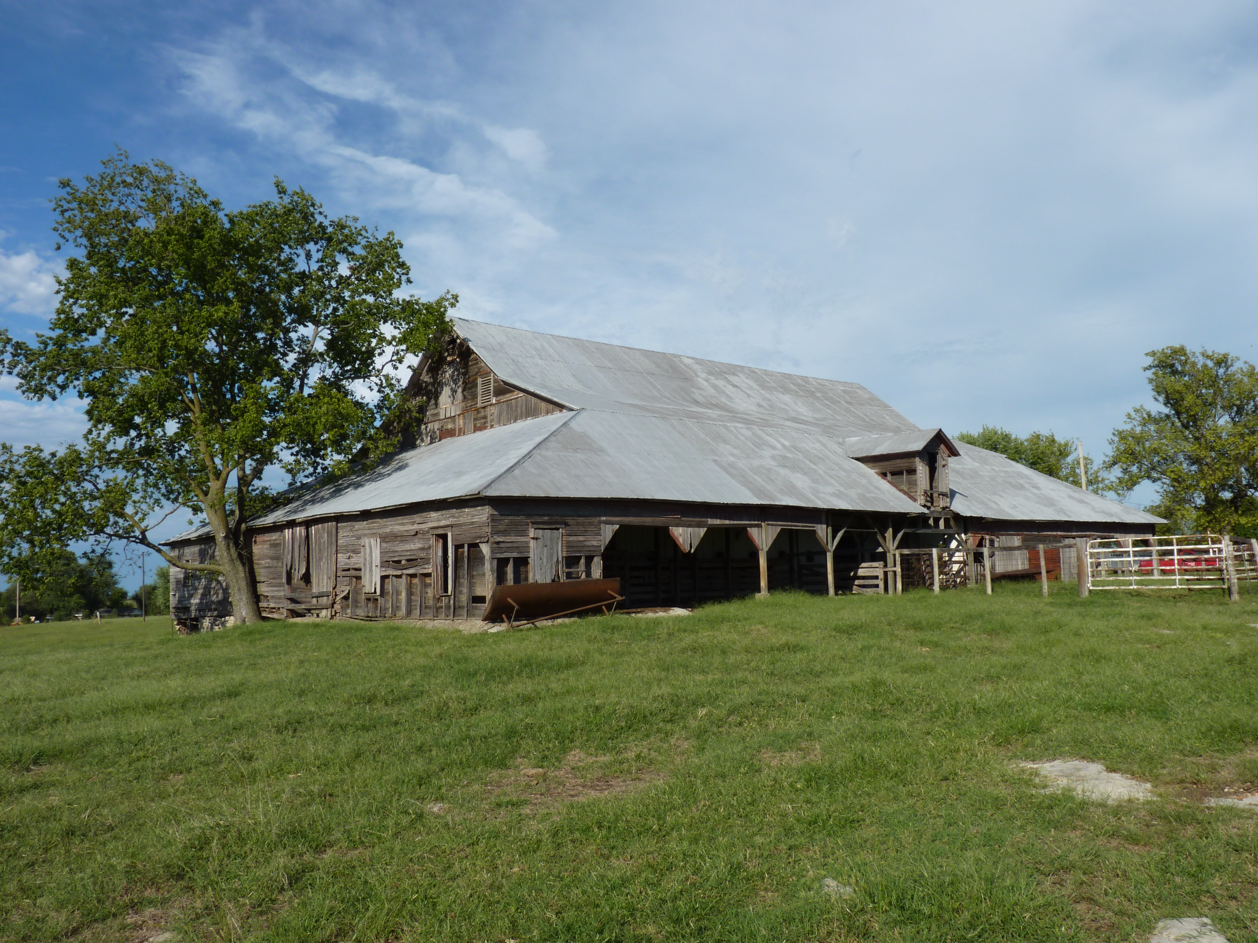
36°41′49″N 94°57′23″W / 36.696944°N 94.956389°WAfton 7 John Patrick McNaughton Barn 
December 27, 1991 Ottawa County Road 137, 1.5 miles north of State Highway 10
36°53′53″N 94°47′07″W / 36.898056°N 94.785278°WQuapaw 8 Miami Downtown Historic District 
May 29, 2009 Roughly the 100 block of N. Main St., the 0 block of S. Main St., the 0 blocks of E. and W. Central Ave., and the 0 block of SE. A St.
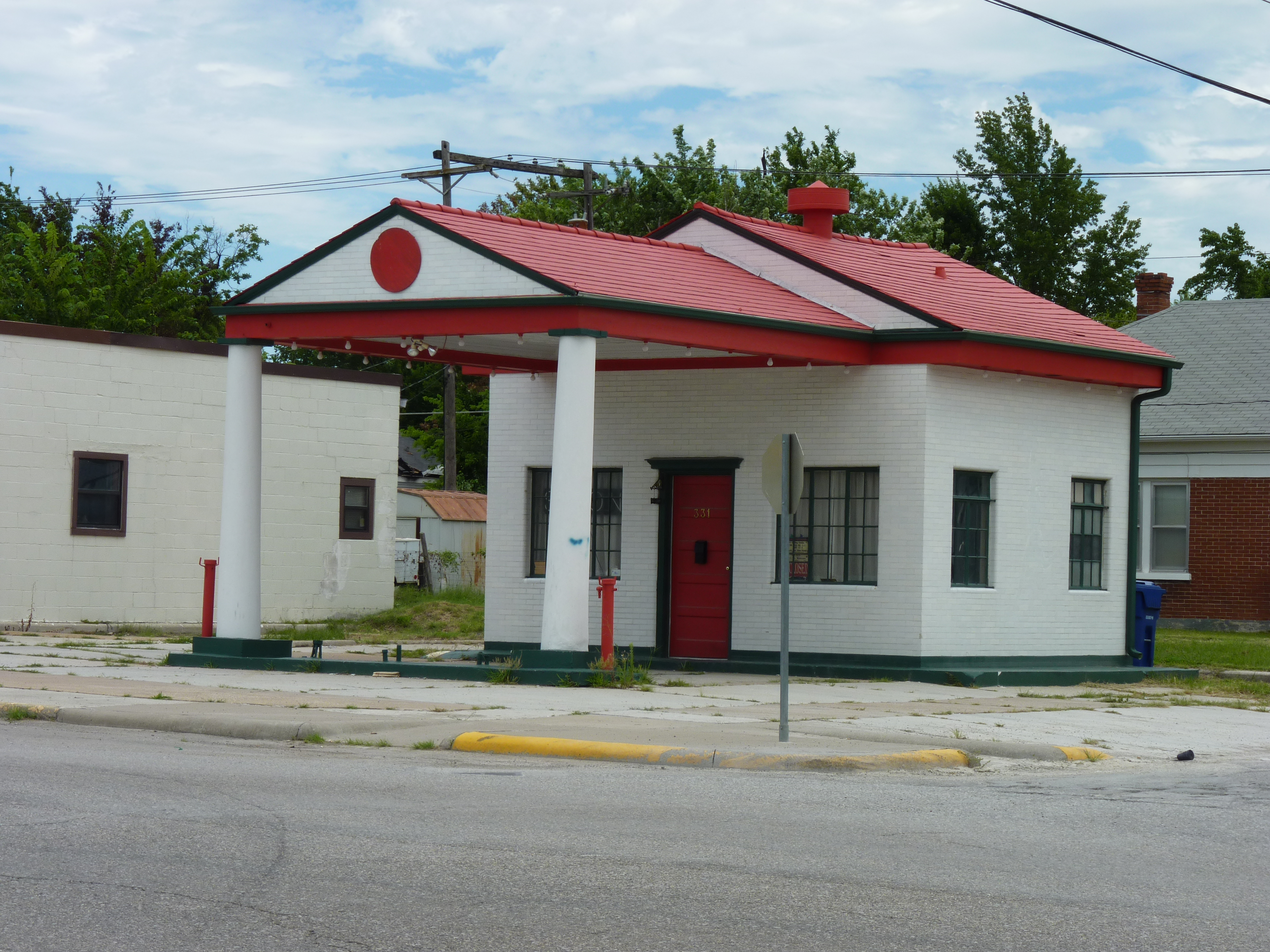
36°52′29″N 94°52′39″W / 36.874722°N 94.8775°WMiami 9 Miami Marathon Oil Company Service Station 
February 23, 1995 331 S. Main St.
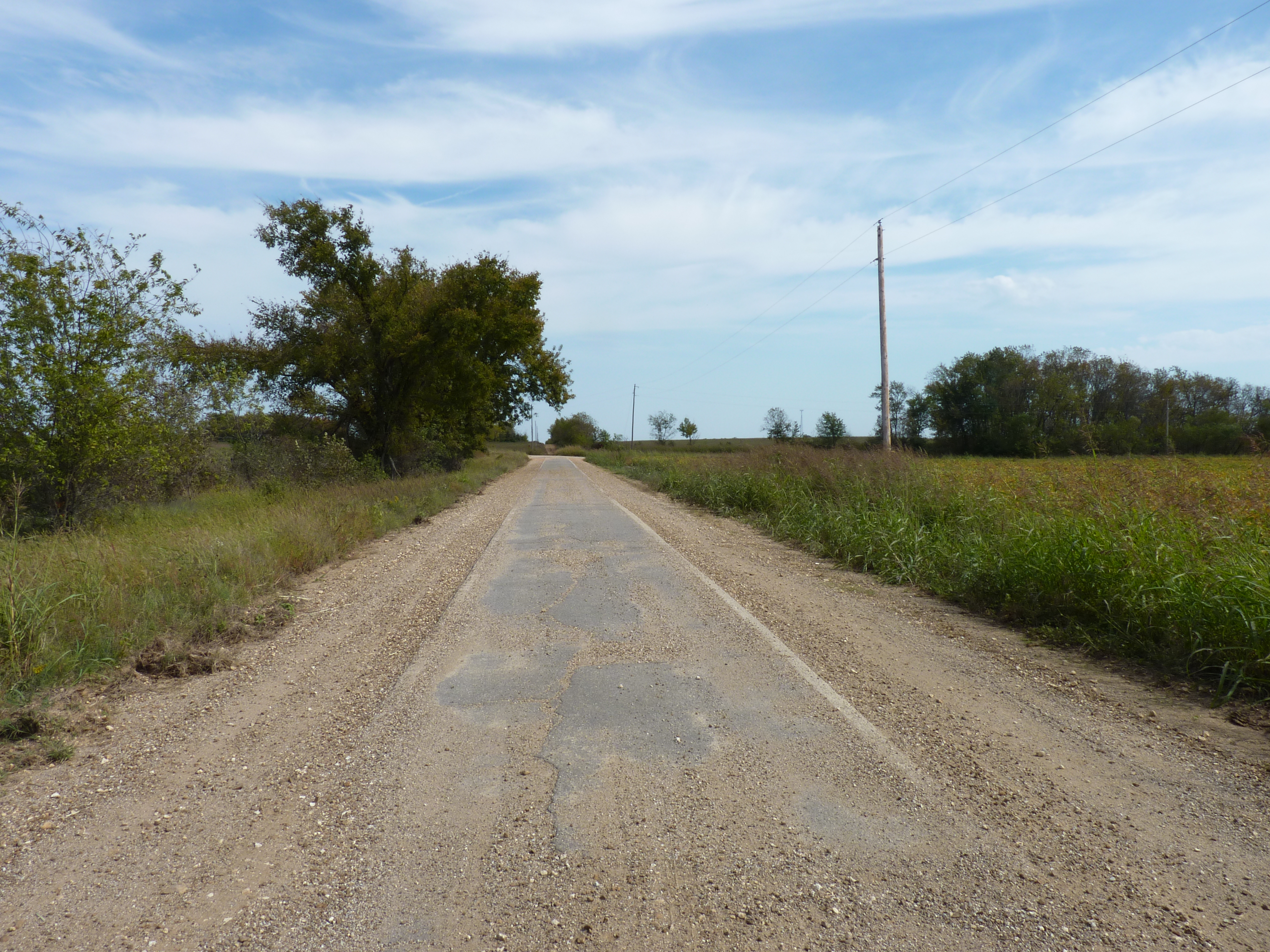
36°52′11″N 94°52′37″W / 36.869722°N 94.876944°WMiami 10 Miami Original Nine-Foot Section of Route 66 Roadbed 
February 9, 1995 From the junction of E St., SW. and 130th St. to the former U.S. Route 66
36°49′22″N 94°54′31″W / 36.822778°N 94.908611°WMiami 11 Modoc Mission Church and Cemetery 
February 15, 1980 Southeast of Miami
36°51′53″N 94°39′43″W / 36.864722°N 94.661944°WMiami 12 Narcissa D-X Gas Station December 5, 2003 15050 S. State Highway 69
36°48′03″N 94°55′36″W / 36.800833°N 94.926667°WMiami 13 Ottawa County Courthouse March 3, 2004 102 East Central
36°52′27″N 94°52′33″W / 36.874167°N 94.875833°WMiami 14 Peoria Indian School 
March 21, 1983 East of Miami
36°54′52″N 94°44′31″W / 36.914444°N 94.741944°WMiami 15 Peoria Tribal Cemetery 
March 21, 1983 East of Miami
36°54′01″N 94°45′39″W / 36.900278°N 94.760833°WMiami 16 Riviera Courts-Motel 
May 27, 2004 1 mile west of Main on U.S. Route 69A
36°51′56″N 94°54′01″W / 36.865556°N 94.900278°WMiami 17 Tri-State Zinc and Lead Ore Producers Association Office 
March 7, 2003 508 N. Connell Ave.
36°59′28″N 94°49′52″W / 36.991111°N 94.831111°WPicher See also
- List of National Historic Landmarks in Oklahoma
- National Register of Historic Places listings in Oklahoma
References
- ^ The latitude and longitude information provided in this table was derived originally from the National Register Information System, which has been found to be fairly accurate for about 99% of listings. For about 1% of NRIS original coordinates, experience has shown that one or both coordinates are typos or otherwise extremely far off; some corrections may have been made. A more subtle problem causes many locations to be off by up to 150 yards, depending on location in the country: most NRIS coordinates were derived from tracing out latitude and longitudes off of USGS topographical quadrant maps created under the North American Datum of 1927, which differs from the current, highly accurate WGS84 GPS system used by Google maps. Chicago is about right, but NRIS longitudes in Washington are higher by about 4.5 seconds, and are lower by about 2.0 seconds in Maine. Latitudes differ by about 1.0 second in Florida. Some locations in this table may have been corrected to current GPS standards.
- ^ "National Register of Historic Places: Weekly List Actions". National Park Service, United States Department of the Interior. Retrieved on November 10, 2011.
- ^ Numbers represent an ordering by significant words. Various colorings, defined here, differentiate National Historic Landmark sites and National Register of Historic Places Districts from other NRHP buildings, structures, sites or objects.
- ^ "National Register Information System". National Register of Historic Places. National Park Service. . http://nrhp.focus.nps.gov/natreg/docs/All_Data.html.
U.S. National Register of Historic Places Topics Lists by states Alabama • Alaska • Arizona • Arkansas • California • Colorado • Connecticut • Delaware • Florida • Georgia • Hawaii • Idaho • Illinois • Indiana • Iowa • Kansas • Kentucky • Louisiana • Maine • Maryland • Massachusetts • Michigan • Minnesota • Mississippi • Missouri • Montana • Nebraska • Nevada • New Hampshire • New Jersey • New Mexico • New York • North Carolina • North Dakota • Ohio • Oklahoma • Oregon • Pennsylvania • Rhode Island • South Carolina • South Dakota • Tennessee • Texas • Utah • Vermont • Virginia • Washington • West Virginia • Wisconsin • WyomingLists by territories Lists by associated states Other Municipalities and communities of Ottawa County, Oklahoma Cities 
Towns CDPs Unincorporated
communitiesHockerville | Kellyville | Lincolnville | Narcissa | Ogeechee | Sunshine Valley | Zincville
Ghost towns Categories:- Ottawa County, Oklahoma
- National Register of Historic Places in Oklahoma by county
- Buildings and structures in Ottawa County, Oklahoma
-


Wikimedia Foundation. 2010.