- National Register of Historic Places listings in Park County, Wyoming
-
 Location of Park County in Wyoming
This is a list of the National Register of Historic Places listings in Park County, Wyoming. It is intended to be a complete list of the properties and districts on the National Register of Historic Places in Park County, Wyoming, United States. The locations of National Register properties and districts for which the latitude and longitude coordinates are included below, may be seen in a Google map.[1]
There are 38 properties and districts listed on the National Register in the county, 6 of which are National Historic Landmarks.
-
- This National Park Service list is complete through NPS recent listings posted November 10, 2011.[2]
Contents: Counties in Wyoming Albany - Big Horn - Campbell - Carbon - Converse - Crook - Fremont - Goshen - Hot Springs - Johnson - Laramie - Lincoln - Natrona - Niobrara - Park - Platte - Sheridan - Sublette - Sweetwater - Teton - Uinta - Washakie - Weston Listings county-wide
See also
- List of National Historic Landmarks in Wyoming
- National Register of Historic Places listings in Wyoming
References
- ^ The latitude and longitude information provided in this table was derived originally from the National Register Information System, which has been found to be fairly accurate for about 99% of listings. For about 1% of NRIS original coordinates, experience has shown that one or both coordinates are typos or otherwise extremely far off; some corrections may have been made. A more subtle problem causes many locations to be off by up to 150 yards, depending on location in the country: most NRIS coordinates were derived from tracing out latitude and longitudes off of USGS topographical quadrant maps created under North American Datum of 1927, which differs from the current, highly accurate GPS system used by Google maps. Chicago is about right, but NRIS longitudes in Washington are higher by about 4.5 seconds, and are lower by about 2.0 seconds in Maine. Latitudes differ by about 1.0 second in Florida. Some locations in this table may have been corrected to current GPS standards.
- ^ "National Register of Historic Places: Weekly List Actions". National Park Service, United States Department of the Interior. Retrieved on November 10, 2011.
- ^ Numbers represent an ordering by significant words. Various colorings, defined here, differentiate National Historic Landmark sites and National Register of Historic Places Districts from other NRHP buildings, structures, sites or objects.
- ^ Location derived from this Wyoming State Historic Preservation Office webpage; the NRIS lists the site as "Address Restricted".
- ^ Location derived from pages 179, 180, and 182 of this document; the NRIS lists the site as "Address Restricted"
- ^ Location derived from this Wyoming State Historic Preservation Office webpage and from Husted, Wilfred M., and Robert Edgar. The Archeology of Mummy Cave, Wyoming: An Introduction to Shoshonean Prehistory, page xii. Midwest Archeological Center and Southeast Archeological Center via the National Park Service, 2002. Accessed 2009-07-29. The NRIS lists the site as "Address Restricted"
U.S. National Register of Historic Places Topics Lists by states Alabama • Alaska • Arizona • Arkansas • California • Colorado • Connecticut • Delaware • Florida • Georgia • Hawaii • Idaho • Illinois • Indiana • Iowa • Kansas • Kentucky • Louisiana • Maine • Maryland • Massachusetts • Michigan • Minnesota • Mississippi • Missouri • Montana • Nebraska • Nevada • New Hampshire • New Jersey • New Mexico • New York • North Carolina • North Dakota • Ohio • Oklahoma • Oregon • Pennsylvania • Rhode Island • South Carolina • South Dakota • Tennessee • Texas • Utah • Vermont • Virginia • Washington • West Virginia • Wisconsin • WyomingLists by territories Lists by associated states Other  Category:National Register of Historic Places •
  Portal:National Register of Historic Places
Municipalities and communities of Park County, Wyoming County seat: Cody Cities 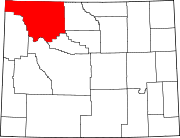
Towns CDPs Unincorporated
communitiesGhost town Yanceys
Footnotes ‡This populated place also has portions in an adjacent county or counties
Categories:- National Register of Historic Places in Wyoming by county
- Park County, Wyoming
-


Wikimedia Foundation. 2010.