There are 400 properties and districts listed on the National Register in Providence County, including 15 National Historic Landmarks. The city of Pawtucket is the location of 50 these properties and districts, including 1 National Historic Landmark; they are listed here. Properties and districts located in the county's other municipalities are listed separately.
| [3] |
Landmark name[4] |
Image |
Date listed |
Location |
Summary |
| 1 |
John E. Adams House |
|
01983-11-18 November 18, 1983 |
11 Allen Ave.
41°52′59″N 71°22′38″W / 41.88306°N 71.37722°W / 41.88306; -71.37722 (Adams, John E., House) |
|
| 2 |
Art's Auto |
|
01978-12-15 December 15, 1978 |
5-7 Lonsdale Ave.
41°52′7″N 71°23′56″W / 41.86861°N 71.39889°W / 41.86861; -71.39889 (Art's Auto) |
|
| 3 |
Bridge Mill Power Plant |
 |
01983-11-18 November 18, 1983 |
25 Roosevelt Ave.
41°52′35″N 71°23′4″W / 41.87639°N 71.38444°W / 41.87639; -71.38444 (Bridge Mill Power Plant) |
|
| 4 |
G.A. Burnham House |
|
01983-11-18 November 18, 1983 |
17 Nickerson St.
41°52′58″N 71°23′20″W / 41.88278°N 71.38889°W / 41.88278; -71.38889 (Burnham, G.A., House) |
|
| 5 |
Childs-Brown House |
|
01983-11-18 November 18, 1983 |
172 Pine St.
41°52′27.83″N 71°23′23.06″W / 41.8743972°N 71.3897389°W / 41.8743972; -71.3897389 (Childs--Brown House) |
|
| 6 |
Church Hill Grammar School |
|
02010-04-23 April 23, 2010 |
81 Park Pl.
41°52′33.16″N 71°23′15.7″W / 41.8758778°N 71.387694°W / 41.8758778; -71.387694 (Church Hill Grammar School) |
|
| 7 |
Church Hill Industrial District |
 |
01982-08-12 August 12, 1982 |
Roughly bounded by S. Union, Pine, Baley, Commerce, Main, and Hill Sts.
41°52′34″N 71°23′22″W / 41.87611°N 71.38944°W / 41.87611; -71.38944 (Church Hill Industrial District)
Boundary increase (listed 2/7/2011): 60 Dexter St., 125 Goff Ave., 265 Pine St. |
|
| 8 |
Collyer Monument |
|
01983-11-18 November 18, 1983 |
Mineral Spring Park
41°52′29″N 71°23′35″W / 41.87472°N 71.39306°W / 41.87472; -71.39306 (Collyer Monument) |
|
| 9 |
Conant Thread-Coats & Clark Mill Complex District |
 |
01983-11-18 November 18, 1983 |
Roughly bounded by Lonsdale Ave., Pine, Conant, Carpenter, and Rand Sts.
41°52′51″N 71°23′53″W / 41.88083°N 71.39806°W / 41.88083; -71.39806 (Conant Thread--Coats & Clark Mill Complex District) |
|
| 10 |
Lorenzo Crandall House |
|
01984-12-10 December 10, 1984 |
221 High St.
41°52′53″N 71°23′3″W / 41.88139°N 71.38417°W / 41.88139; -71.38417 (Crandall, Lorenzo, House) |
|
| 11 |
Division Street Bridge |
 |
01983-11-18 November 18, 1983 |
Division St. at the Seekonk River
41°52′20″N 71°23′6″W / 41.87222°N 71.385°W / 41.87222; -71.385 (Division Street Bridge) |
|
| 12 |
Downtown Pawtucket Historic District |
|
02007-04-05 April 5, 2007 |
Roughly bounded by Broad St., Grant St., High St., the East Ave. Extension, and Main St.
41°52′43.29″N 71°23′5.48″W / 41.8786917°N 71.3848556°W / 41.8786917; -71.3848556 (Downtown Pawtucket Historic District) |
|
| 13 |
Exchange Street Historic District |
|
02002-09-06 September 6, 2002 |
Roughly along Exchange, Front and Fountain Sts.
41°52′47″N 71°22′50″W / 41.87972°N 71.38056°W / 41.87972; -71.38056 (Exchange Street Historic District) |
|
| 14 |
Fifth Ward Wardroom |
|
01983-11-18 November 18, 1983 |
47 Mulberry St.
41°52′27″N 71°23′36″W / 41.87417°N 71.39333°W / 41.87417; -71.39333 (Fifth Ward Wardroom) |
|
| 15 |
Fire Station No. 4 |
|
01983-11-18 November 18, 1983 |
474 Broadway
41°53′11″N 71°22′36″W / 41.88639°N 71.37667°W / 41.88639; -71.37667 (Fire Station No. 4) |
|
| 16 |
First Ward Wardroom |
|
01983-11-18 November 18, 1983 |
171 Fountain St.
41°53′3.74″N 71°22′41.07″W / 41.8843722°N 71.378075°W / 41.8843722; -71.378075 (First Ward Wardroom) |
|
| 17 |
Foster-Payne House |
|
01983-11-18 November 18, 1983 |
25 Belmont St.
41°51′46.05″N 71°23′44.9″W / 41.8627917°N 71.395806°W / 41.8627917; -71.395806 (Foster--Payne House) |
|
| 18 |
Fuller Houses |
|
01983-11-18 November 18, 1983 |
339-341 and 343-345 Broadway
41°53′4″N 71°22′38″W / 41.88444°N 71.37722°W / 41.88444; -71.37722 (Fuller Houses) |
|
| 19 |
Gilbane's Service Center Building |
|
01983-11-18 November 18, 1983 |
175-191 Pawtucket Ave.
41°52′9″N 71°23′21″W / 41.86917°N 71.38917°W / 41.86917; -71.38917 (Gilbane's Service Center Building) |
|
| 20 |
Hope Webbing Company Mill |
 |
02006-04-19 April 19, 2006 |
999-1005 Main St.
41°51′46″N 71°24′4″W / 41.86278°N 71.40111°W / 41.86278; -71.40111 (Hope Webbing Company Mill) |
|
| 21 |
Louis Kotzow House |
|
01983-11-18 November 18, 1983 |
641 East Ave.
41°51′37″N 71°23′24″W / 41.86028°N 71.39°W / 41.86028; -71.39 (Kotzow, Louis, House) |
|
| 22 |
Leroy Theatre |
|
01983-08-04 August 4, 1983 |
66 Broad St.
41°52′48″N 71°23′15″W / 41.88°N 71.3875°W / 41.88; -71.3875 (Leroy Theatre) |
|
| 23 |
Liberty Arming the Patriot |
|
02001-10-19 October 19, 2001 |
Park Place
41°52′37″N 71°23′14″W / 41.87694°N 71.38722°W / 41.87694; -71.38722 (Liberty Arming the Patriot) |
|
| 24 |
Main Street Bridge |
 |
01983-11-18 November 18, 1983 |
Main St. at Pawtucket Falls
41°52′35″N 71°23′2″W / 41.87639°N 71.38389°W / 41.87639; -71.38389 (Main Street Bridge) |
|
| 25 |
Mitchell-Arnold House |
|
01983-11-18 November 18, 1983 |
41 Waldo St.
41°51′58″N 71°23′27″W / 41.86611°N 71.39083°W / 41.86611; -71.39083 (Mitchell--Arnold House) |
|
| 26 |
Modern Diner |
 |
01978-10-19 October 19, 1978 |
364 East Ave.
41°52′8″N 71°23′13″W / 41.86889°N 71.38694°W / 41.86889; -71.38694 (Modern Diner) |
|
| 27 |
Nathaniel Montgomery House |
|
01984-01-19 January 19, 1984 |
178 High St.
41°52′51″N 71°23′5″W / 41.88083°N 71.38472°W / 41.88083; -71.38472 (Montgomery, Nathaniel, House) |
|
| 28 |
Old Slater Mill |
 |
01966-11-13 November 13, 1966 |
Roosevelt Ave.
41°52′39″N 71°22′57″W / 41.8775°N 71.3825°W / 41.8775; -71.3825 (Old Slater Mill) |
|
| 29 |
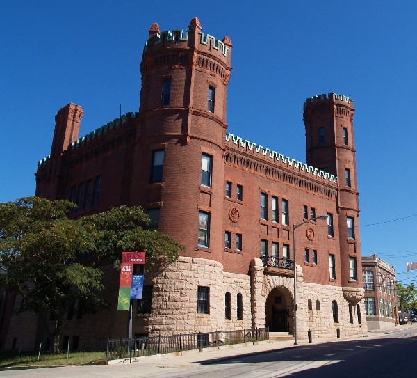
Pawtucket Armory |
 |
01983-11-18 November 18, 1983 |
172 Exchange St.
41°52′49″N 71°22′49″W / 41.88028°N 71.38028°W / 41.88028; -71.38028 (Pawtucket Armory) |
|
| 30 |
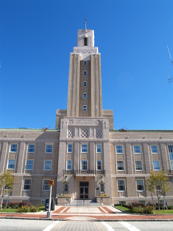
Pawtucket City Hall |
 |
01983-11-18 November 18, 1983 |
137 Roosevelt Ave.
41°52′45″N 71°22′57″W / 41.87917°N 71.3825°W / 41.87917; -71.3825 (Pawtucket City Hall) |
|
| 31 |
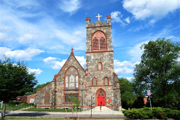
Pawtucket Congregational Church |
 |
01978-09-18 September 18, 1978 |
40 and 56 Walcott St.
41°52′36″N 71°22′54″W / 41.87667°N 71.38167°W / 41.87667; -71.38167 (Pawtucket Congregational Church) |
|
| 32 |
Pawtucket Elks Lodge Building |
 |
01983-11-18 November 18, 1983 |
27 Exchange
41°52′47.21″N 71°23′8.04″W / 41.8797806°N 71.3855667°W / 41.8797806; -71.3855667 (Pawtucket Elks Lodge Building) |
|
| 33 |
Pawtucket Post Office |
 |
01976-04-30 April 30, 1976 |
56 High St.
41°52′42″N 71°23′4″W / 41.87833°N 71.38444°W / 41.87833; -71.38444 (Pawtucket Post Office) |
|
| 34 |
Pawtucket Times Building |
 |
01983-11-18 November 18, 1983 |
23 Exchange St.
41°52′47.1″N 71°23′8.51″W / 41.87975°N 71.3856972°W / 41.87975; -71.3856972 (Pawtucket Times Building) |
|
| 35 |
Pawtucket West High School |
|
01983-11-18 November 18, 1983 |
485 East Ave.
41°51′55″N 71°23′19″W / 41.86528°N 71.38861°W / 41.86528; -71.38861 (Pawtucket West High School) |
|
| 36 |
Charles Payne House |
|
01983-11-18 November 18, 1983 |
25 Brown St.
41°52′17″N 71°23′29″W / 41.87139°N 71.39139°W / 41.87139; -71.39139 (Payne, Charles, House) |
|
| 37 |
Phillips Insulated Wire Company Complex |
 |
02004-03-19 March 19, 2004 |
413 Central Ave.
41°53′4″N 71°21′59″W / 41.88444°N 71.36639°W / 41.88444; -71.36639 (Phillips Insulated Wire Company Complex) |
|
| 38 |
Pitcher-Goff House |
|
01976-06-24 June 24, 1976 |
56 Walcott St.
41°52′37″N 71°22′49″W / 41.87694°N 71.38028°W / 41.87694; -71.38028 (Pitcher--Goff House) |
|
| 39 |
Potter-Collyer House |
|
01983-11-18 November 18, 1983 |
67 Cedar St.
41°52′24″N 71°23′23″W / 41.87333°N 71.38972°W / 41.87333; -71.38972 (Potter--Collyer House) |
|
| 40 |
Quality Hill Historic District |
|
01984-04-13 April 13, 1984 |
Roughly bounded by Interstate 95, Cottage, Lyon, Bend, and Potter Sts.
41°52′40″N 71°22′25″W / 41.87778°N 71.37361°W / 41.87778; -71.37361 (Quality Hill Historic District) |
|
| 41 |
Riverside Cemetery |
|
01983-11-18 November 18, 1983 |
724 Pleasant St.
41°51′33″N 71°22′56″W / 41.85917°N 71.38222°W / 41.85917; -71.38222 (Riverside Cemetery) |
|
| 42 |
St. John the Baptist Church |
 |
01983-11-18 November 18, 1983 |
68 Slater
41°52′24″N 71°23′52″W / 41.87333°N 71.39778°W / 41.87333; -71.39778 (St. John the Baptist Church) |
|
| 43 |
St. Mary's Church of the Immaculate Conception Complex |
|
01983-11-18 November 18, 1983 |
103 Pine St.
41°52′17″N 71°23′21″W / 41.87139°N 71.38917°W / 41.87139; -71.38917 (St. Mary's Church of the Immaculate Conception Complex) |
|
| 44 |
St. Paul's Church |
 |
01983-11-18 November 18, 1983 |
50 Park Pl.
41°52′32″N 71°23′14″W / 41.87556°N 71.38722°W / 41.87556; -71.38722 (St. Paul's Church) |
|
| 45 |
Deborah Cook Sayles Public Library |
 |
01975-12-06 December 6, 1975 |
13 Summer St.
41°52′44″N 71°23′7″W / 41.87889°N 71.38528°W / 41.87889; -71.38528 (Sayles, Deborah Cook, Public Library) |
|
| 46 |
Scholze-Sayles House |
|
01983-11-18 November 18, 1983 |
625 East Ave.
41°51′38.82″N 71°23′21.28″W / 41.8607833°N 71.3892444°W / 41.8607833; -71.3892444 (Scholze--Sayles House) |
|
| 47 |
Slater Park |
 |
01976-06-30 June 30, 1976 |
Armistice Boulevard
41°52′7″N 71°20′43″W / 41.86861°N 71.34528°W / 41.86861; -71.34528 (Slater Park) |
|
| 48 |
South Street Historic District |
|
01983-11-18 November 18, 1983 |
Roughly South Street between Meadow and Fruit Sts.
41°52′17″N 71°22′47″W / 41.87139°N 71.37972°W / 41.87139; -71.37972 (South Street Historic District) |
|
| 49 |
Joseph Spaulding House |
|
01976-10-22 October 22, 1976 |
30 Fruit St.
41°52′26″N 71°22′50″W / 41.87389°N 71.38056°W / 41.87389; -71.38056 (Spaulding, Joseph, House) |
|
| 50 |
Trinity Church |
|
01972-01-13 January 13, 1972 |
50 Main St.
41°52′33.19″N 71°22′51.59″W / 41.8758861°N 71.3809972°W / 41.8758861; -71.3809972 (Trinity Church) |
|
 Location of Pawtucket in Rhode Island
 Category:National Register of Historic Places •
  Portal:National Register of Historic PlacesCategories: