- National Register of Historic Places listings in Prescott, Arizona
-
 Location of Prescott in Arizona
This is a list of the National Register of Historic Places listings in Prescott, Arizona. It is intended to be a complete list of the properties and districts on the National Register of Historic Places in Prescott, Arizona, United States. The locations of National Register properties and districts for which the latitude and longitude coordinates are included below, may be seen in a Google map.[1]
There are 131 properties and districts listed on the National Register in Yavapai County, including 1 that is also a National Historic Landmark. 71 of these properties and districts are located in the city of Prescott, and are listed here, while the remaining 60 properties and districts are located elsewhere in the county, and are listed separately.
-
- This National Park Service list is complete through NPS recent listings posted November 10, 2011.[2]
Current listings
[3] Landmark name[4] Image Date listed Location Summary 1 Arizona Pioneers' Home 
November 20, 1995 300 S. McCormick St.
34°32′15″N 112°28′25″W / 34.5375°N 112.47361°WRetirement home complex overlooking Prescott 2 Blumberg House December 14, 1978 143 N. Mt. Vernon
34°32′36.33″N 112°27′47.48″W / 34.543425°N 112.4631889°W3 Brinkmeyer House December 14, 1978 605 W. Gurley 4 Burmister/Timerhoff House December 14, 1978 116 S. Mt. Vernon 5 Clark House December 14, 1978 109 N. Pleasant 6 Courthouse Plaza Historic District December 14, 1978 Roughly bounded by Gurley, Montezuma, Cortez, and Goodwin Sts. 7 Curtis Cottage May 4, 1993 125 S. McCormick
34°32′33″N 112°28′22″W / 34.5425°N 112.47278°W8 Day House December 14, 1978 212 E. Gurley 9 Detwiler House December 14, 1978 310 N. Alarcon 10 Drake House December 14, 1978 137 N. Mt. Vernon 11 Charles H. Dunning Log Cabin August 26, 1993 811 Boulder Dr.
34°31′40″N 112°28′59″W / 34.52778°N 112.48306°W12 East Prescott Historic District October 2, 1989 Roughly bounded by Atchison, Topeka, and Santa Fe railroad tracks, N. Mt. Vernon St., Carleton St., and N. Alarcon St.
34°32′35″N 112°27′49″W / 34.54306°N 112.46361°W13 Elks Building and Theater December 14, 1978 117 E. Gurley 14 First Congregational Church and Parsonage December 14, 1978 216-220 E. Gurley 15 Fisher/Goldwater House December 14, 1978 240 S. Cortez 16 Fleury's Addition Historic District December 27, 1994 Roughly Western and Gurley from Willow to Grove, and Willow, Garden, and Grove from Western to Gurley
34°33′26″N 112°27′55″W / 34.55722°N 112.46528°W17 Fort Whipple-Department of Veterans Affairs Medical Center Historic District October 29, 1999 500 State Route 89 N.
34°32′58″N 112°27′4″W / 34.54944°N 112.45111°WFort Whipple, Arizona 18 Fredericks House December 14, 1978 202 S. Pleasant 19 Gage/Murphy House December 14, 1978 105 S. Alarcon 20 James I. Gardner Store January 9, 1985 201 N. Cortez
34°32′43″N 112°28′16″W / 34.54528°N 112.47111°W21 Henry Goldwater House March 25, 1982 217 E. Union St.
34°32′27″N 112°27′55″W / 34.54083°N 112.46528°W22 Groom Creek School November 18, 1992 Senator Highway southeast of Prescott in the Prescott National Forest
34°28′15″N 112°26′2″W / 34.47083°N 112.43389°W23 Hassayampa Historic District May 30, 2003 1089-1112 Old Hassayampa Ln. and 1106 Country Club Dr.
34°32′8″N 112°29′24″W / 34.53556°N 112.49°W24 Hassayampa Hotel November 29, 1979 122 E. Gurley St
34°32′32″N 112°28′1″W / 34.54222°N 112.46694°WSpanish Colonial Revival design by Henry Trost, architect, 1927 [1] 25 Hawkins House December 14, 1978 122 S. Mt. Vernon 26 Hazeltine House December 14, 1978 202 S. Mt. Vernon 27 Head House December 14, 1978 309 E. Gurley 28 Hill House December 14, 1978 144 S. Park 29 Sam Hill Hardware December 14, 1978 154 S. Montezuma 30 Samuel Hill Hardware Company Warehouse September 13, 1984 232 N. McCormick St.
34°32′44″N 112°28′16″W / 34.54556°N 112.47111°W31 Hotel Vendome 
November 25, 1983 230 S. Cortez
34°32′20″N 112°28′6″W / 34.53889°N 112.46833°WOperating hotel 32 Indian Peak Ruin (AR-03-09-06-116) January 20, 1989 Address Restricted Sinagua ruin 33 Iron Turbine Windmill 
July 9, 1981 415 W. Gurley St.
34°32′30″N 112°28′27″W / 34.54167°N 112.47417°WPart of Sharlot Hall Museum 34 Joslin and Whipple Historic District December 7, 2000 S. Mt. Vernon, Virginia, Washington, and Arizona Sts.
34°32′19″N 112°27′42″W / 34.53861°N 112.46167°W35 Kenwill Apartments January 21, 1988 119-127 E. Goodwin St.
34°32′23″N 112°28′1″W / 34.53972°N 112.46694°W36 Lawler-Hetherington Double House December 14, 1978 223 E. Union 37 Lynx Creek Bridge September 30, 1988 5.9 mi (9.5 km) east of Prescott on the Old Black Canyon Highway
34°33′8″N 112°22′21″W / 34.55222°N 112.3725°W38 Lynx Creek District August 31, 1978 East of Prescott
34°34′28″N 112°20′50″W / 34.57444°N 112.34722°W39 Marks House December 14, 1978 203 E. Union 40 Martin/Ling House December 14, 1978 125 N. Pleasant 41 Mile High Park Historic District September 3, 1999 Roughly along Oregon Ave. and Josephine St. from Gail Gardner Way and Lindberg Dr.
34°32′49″N 112°29′36″W / 34.54694°N 112.49333°W42 Morin House December 14, 1978 134 N. Mt. Vernon 43 former LDS Church December 22, 1983 126 N. Marina St.
34°32′35″N 112°28′1″W / 34.54306°N 112.46694°WConverted to commercial use in 1982. 44 Morrison House December 14, 1978 300 S. Marina 45 Mountain States Telephone and Telegraph Exchange Building (Prescott, Arizona) September 16, 2004 116 N. Marina St.
34°32′38″N 112°28′5″W / 34.54389°N 112.46806°W46 Mulvenon Building April 15, 1993 230 W. Gurley St.
34°32′32″N 112°28′17″W / 34.54222°N 112.47139°W47 North Prescott Townsite Historic District May 13, 2009 Between Gurley, Sheldon, Alarcon and Summit Sts.
34°32′37.71″N 112°28′10.74″W / 34.5438083°N 112.46965°W48 Old Governor's Mansion 
September 10, 1971 415 W. Gurley
34°32′29″N 112°28′23″W / 34.54139°N 112.47306°W[5]Now part of the Sharlot Hall Museum [5] 49 Otis House December 14, 1978 113 N. Pleasant 50 Palace Station District April 30, 1976 23 mi (37 km) south of Prescott in the Prescott National Forest
34°22′35″N 112°24′32″W / 34.37639°N 112.40889°WStagecoach station, built 1874 [2] 51 Peter House December 14, 1978 211 E. Union 52 Pine Crest Historic District August 10, 1989 Roughly bounded by San Carlos St., Coronado Ave., and Yavapai, Apache, and Mohave Drs.
34°32′19″N 112°29′3″W / 34.53861°N 112.48417°W53 Prescott Armory Historic District 
August 15, 1994 Roughly bounded by E. Gurley, E. Willis, N. Arizona, E. Sheldon, and N. Rush Sts.
34°33′26″N 112°26′26″W / 34.55722°N 112.44056°W54 Prescott Public Library 
May 28, 1975 125 E. Gurley St.
34°32′28″N 112°28′2″W / 34.54111°N 112.46722°WOld Carnegie library, now an office building 55 Roberts House December 14, 1978 136 N. Pleasant 56 A. W. Robinson Building December 14, 1978 115 N. Grove 57 Sacred Heart Catholic Church and Rectory December 14, 1978 208 N. Marina Now used as the Prescott Fine Arts Association gallery 58 Santa Fe, Prescott and Phoenix Railroad Depot February 8, 1988 Cortez St.
34°32′43″N 112°28′5″W / 34.54528°N 112.46806°W59 Sewall House December 14, 1978 220 N. Mt. Vernon 60 Shekels House December 14, 1978 226 S. Cortez 61 Sloan House December 14, 1978 128 N. Mt. Vernon 62 South Prescott Townsite August 31, 1998 Roughly bounded by Alarcon, Montezuma, Union, and Leroux Sts.
34°32′11″N 112°28′4″W / 34.53639°N 112.46778°W63 Toltec Lodge July 20, 2000 228 High St.
34°32′23″N 112°28′47″W / 34.53972°N 112.47972°W64 US Post Office and Courthouse-Prescott Main 
December 3, 1985 101 W. Goodwin Ave.
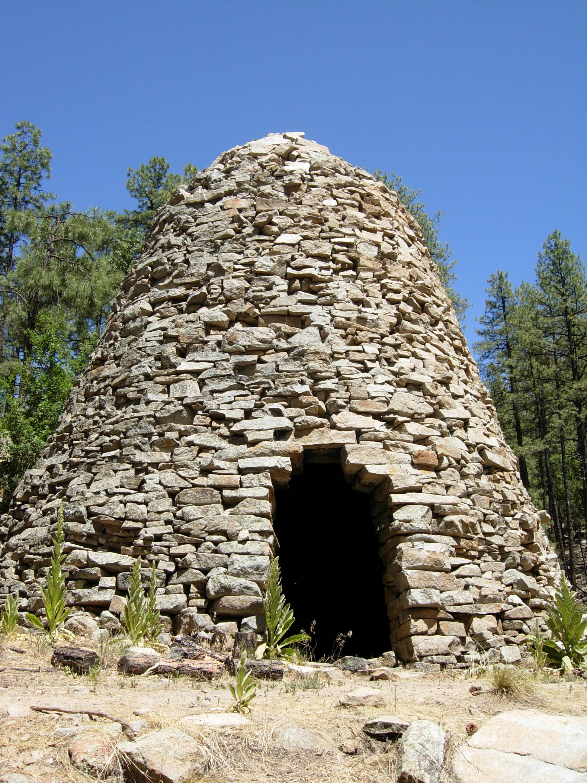
34°32′24″N 112°28′9″W / 34.54°N 112.46917°W65 Walker Charcoal Kiln 
October 8, 1976 Southeast of Prescott in the Prescott National Forest
34°27′30″N 112°22′31″W / 34.45833°N 112.37528°W66 Walnut Creek Ranger Station June 10, 1993 Northwest of Prescott in the Prescott National Forest
34°55′28″N 112°50′24″W / 34.92444°N 112.84°W67 Wells House December 14, 1978 303 S. Cortez 68 West Prescott Historic District August 10, 1989 Roughly bounded by Gurley Dr., Park Ave., Country Club Dr., Vista Dr., and Coronado Ave.; also 617-621 Glenwood Ave. and 330, 334, 340, 344, and 348 Moreland Circle
34°32′15″N 112°28′41″W / 34.5375°N 112.47806°WSecond set of addresses represents a boundary increase 69 Whipple Heights Historic District December 7, 2000 E. Gurley, N. Virginia, Washington, and E. Moeller Sts.
34°32′36″N 112°27′40″W / 34.54333°N 112.46111°W70 Wilder House December 14, 1978 346 S. Montezuma 71 Yavapai County Courthouse 
April 13, 1977 Courthouse Sq.
34°32′27″N 112°28′6″W / 34.54083°N 112.46833°W1918 Greek Revival style building [3] See also
- List of National Historic Landmarks in Arizona
- National Register of Historic Places listings in Arizona
References
- ^ The latitude and longitude information provided in this table was derived originally from the National Register Information System, which has been found to be fairly accurate for about 99% of listings. For about 1% of NRIS original coordinates, experience has shown that one or both coordinates are typos or otherwise extremely far off; some corrections may have been made. A more subtle problem causes many locations to be off by up to 150 yards, depending on location in the country: most NRIS coordinates were derived from tracing out latitude and longitudes off of USGS topographical quadrant maps created under the North American Datum of 1927, which differs from the current, highly accurate WGS84 GPS system used by Google maps. Chicago is about right, but NRIS longitudes in Washington are higher by about 4.5 seconds, and are lower by about 2.0 seconds in Maine. Latitudes differ by about 1.0 second in Florida. Some locations in this table may have been corrected to current GPS standards.
- ^ "National Register of Historic Places: Weekly List Actions". National Park Service, United States Department of the Interior. Retrieved on November 10, 2011.
- ^ Numbers represent an ordering by significant words. Various colorings, defined here, differentiate National Historic Landmark sites and National Register of Historic Places Districts from other NRHP buildings, structures, sites or objects.
- ^ "National Register Information System". National Register of Historic Places. National Park Service. 2008-04-24. http://nrhp.focus.nps.gov/natreg/docs/All_Data.html.
- ^ a b Address derived from this National Park Service website; the NRIS lists it at "400 block of W. Gurley".
U.S. National Register of Historic Places Topics Lists by states Alabama • Alaska • Arizona • Arkansas • California • Colorado • Connecticut • Delaware • Florida • Georgia • Hawaii • Idaho • Illinois • Indiana • Iowa • Kansas • Kentucky • Louisiana • Maine • Maryland • Massachusetts • Michigan • Minnesota • Mississippi • Missouri • Montana • Nebraska • Nevada • New Hampshire • New Jersey • New Mexico • New York • North Carolina • North Dakota • Ohio • Oklahoma • Oregon • Pennsylvania • Rhode Island • South Carolina • South Dakota • Tennessee • Texas • Utah • Vermont • Virginia • Washington • West Virginia • Wisconsin • WyomingLists by territories Lists by associated states Other Categories:- National Register of Historic Places in Arizona
- Prescott, Arizona
-


Wikimedia Foundation. 2010.