- National Register of Historic Places listings in San Mateo County, California
-
This list includes properties and districts listed on the National Register of Historic Places in San Mateo County, California. Click the "Map of all coordinates" link to the right to view a Google map of all properties and districts with latitude and longitude coordinates in the table below.[1]
-
- This National Park Service list is complete through NPS recent listings posted November 10, 2011.[2]
[3] Landmark name [4] Image Date listed Location City or town Summary 1 Archeological Site SMA-151 February 23, 1978 Address Restricted Princeton 2 Barron-Latham-Hopkins Gate Lodge 
August 28, 1986 555 Ravenswood Ave.
37°27′18″N 122°10′42″W / 37.455°N 122.178333°WMenlo Park 3 Bourn-Roth Estate 
August 28, 1975 3.7 mi. northwest of Woodside off Canada Rd.
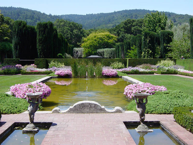
37°28′13″N 122°18′39″W / 37.470278°N 122.310833°WWoodside Also known as Filoli; built in 1915 by Willis Polk for mining magnate William Bourn, owner of the Empire Mine in Grass Valley, California[5] 4 Nathanial Brittan Party House 
December 29, 1994 125 Dale Ave.
37°30′02″N 122°16′15″W / 37.500556°N 122.270833°WSan Carlos 5 Burlingame Railroad Station 
April 19, 1978 Burlingame Ave. and California Dr.
37°34′49″N 122°20′38″W / 37.580278°N 122.343889°WBurlingame 6 The Carolands 
October 21, 1975 565 Remillard Dr.
37°33′20″N 122°22′15″W / 37.555556°N 122.370833°WHillsborough 1914 home of Harriet Pullman Carolan, daughter of George Pullman, inventor of the Pullman sleeping car; built by Willis Polk 7 Casa de Tableta 
August 14, 1973 3915 Alpine Rd.
37°22′56″N 122°11′34″W / 37.382222°N 122.192778°WPortola Valley Now Alpine Inn, formerly known as Rossotti's Saloon since the 1850s. 8 Church of the Nativity 
October 31, 1980 210 Oak Grove Ave.
37°27′39″N 122°10′46″W / 37.460833°N 122.179444°WMenlo Park 9 Ernest Coxhead House 
April 6, 2000 37 E. Santa Inez Ave.
37°34′13″N 122°19′54″W / 37.570278°N 122.331667°WSan Mateo 10 Eugene J. de Sabla, Jr., Teahouse and Tea Garden 
July 30, 1992 70 De Sabla Ave.
37°33′55″N 122°19′49″W / 37.565278°N 122.330278°WSan Mateo Circa 1907 Japanese farmhouse-style teahouse built for Eugene de Sabla, a co-founder of Pacific Gas and Electric Company[6] 11 Dickerman Barn 
January 11, 1982 Cabrillo Hwy.
37°07′09″N 122°18′21″W / 37.119167°N 122.305833°WPescadero 12 First Congregational Church of Pescadero 
October 31, 1980 San Gregorio St.
37°15′16″N 122°22′56″W / 37.254444°N 122.382222°WPescadero 13 Folger Estate Stable Historic District 
April 16, 2004 4040 Woodside Rd.
37°24′30″N 122°15′29″W / 37.408333°N 122.258056°WWoodside 14 Green Gables-Mortimer Fleishhacker Country House September 26, 1986 329 Albion Ave.
37°25′59″N 122°16′02″W / 37.433056°N 122.267222°WWoodside 1911 Arts and Crafts vacation home designed by Charles Sumner Greene[7] 15 Green Oaks Ranch House November 21, 1976 13 mi. S of Pescadero on CA 1
37°08′04″N 122°18′38″W / 37.134444°N 122.310556°WPescadero 16 Arthur and Mona Hofmann House 
August 5, 1991 1048 La Cuesta Rd.
37°33′03″N 122°20′53″W / 37.550833°N 122.348056°WHillsborough 17 Hotel St. Matthew 
January 23, 1998 215-229 Second Ave.
37°33′58″N 122°19′26″W / 37.566111°N 122.323889°WSan Mateo 18 Independence Hall August 3, 1978 2955 Woodside Rd.
37°25′43″N 122°15′37″W / 37.428644°N 122.260325°WWoodside 1884 building that was located at 129 Albion Ave. when added to the National Register. It is now located adjacent to Woodside Town Hall at 2955 Woodside Rd.[8] 19 James Johnston House 
May 9, 1973 Higgins-Purisima Rd.
37°26′59″N 122°25′20″W / 37.449722°N 122.422222°WHalf Moon Bay 20 Kohl Mansion 
February 3, 1982 2750 Adeline Dr.
37°34′57″N 122°22′55″W / 37.5825°N 122.381944°WBurlingame 21 Lathrop House 
April 11, 1973 627 Hamilton St.
37°29′17″N 122°13′48″W / 37.488056°N 122.23°WRedwood City 22 Martin Building 
February 14, 1997 220 Linden Ave.
37°39′18″N 122°24′32″W / 37.655°N 122.40889°W[9]South San Francisco Now known as the Metropolitan Hotel, a residential hotel 23 Menlo Park Railroad Station 
October 1, 1974 1100 Merrill St.
37°27′16″N 122°10′51″W / 37.454444°N 122.180833°WMenlo Park 24 Methodist Episcopal Church at Half Moon Bay 
November 10, 1980 777 Miramontes St.
37°27′46″N 122°25′37″W / 37.462778°N 122.426944°WHalf Moon Bay 25 Methodist Episcopal Church of Pescadero 
March 10, 1982 108 San Gregorio St.
37°15′05″N 122°22′54″W / 37.251389°N 122.381667°WPescadero 26 Robert Mills Dairy Barn 
February 15, 1990 Higgins Purissima Rd.
37°27′20″N 122°23′18″W / 37.455556°N 122.388333°WHalf Moon Bay 27 National Bank of San Mateo 
April 24, 1997 164 S. B St.
37°34′00″N 122°19′20″W / 37.566667°N 122.322222°WSan Mateo 28 New Sequoia Theater Building 
May 5, 1994 2211-2235 Broadway
37°29′11″N 122°13′47″W / 37.486389°N 122.229722°WRedwood City 29 Newhall Estate 
April 13, 2007 1761 Manor Dr.
37°34′42″N 122°21′39″W / 37.578333°N 122.360833°WHillsborough 30 Our Lady of the Wayside 
November 22, 1977 930 Portola Rd.
37°23′02″N 122°13′58″W / 37.383889°N 122.232778°WPortola Valley 31 Pigeon Point Lighthouse 
March 8, 1977 S of Pescadero at Pigeon Point off CA 1
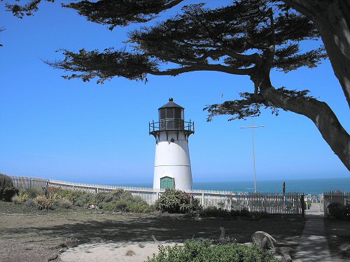
37°10′54″N 122°23′38″W / 37.181667°N 122.393889°WPescadero 32 Point Montara Light Station 
September 3, 1991 Jct. of 16th St. and CA 1
37°32′13″N 122°31′05″W / 37.536944°N 122.518056°WMontara 33 Portola Valley School 
June 28, 1974 775 Portola Rd.
37°22′56″N 122°13′40″W / 37.382222°N 122.227778°WPortola Valley Later used as town hall. 34 Princeton Hotel 
January 31, 1979 Capistrano Rd. and Prospect Way
37°30′18″N 122°29′08″W / 37.505°N 122.485556°WPrinceton 35 William C. Ralston House 
November 15, 1966 College of Notre Dame campus
37°31′03″N 122°17′10″W / 37.5175°N 122.286111°WBelmont 36 Redwood City Historic Commercial Buildings 
November 7, 1977 Broadway and Main Sts.
37°29′12″N 122°13′35″W / 37.486667°N 122.226389°WRedwood City 37 San Francisco Bay Discovery Site 
May 23, 1968 Sweeney Ridge; 4 mi. west of San Bruno via Skyline Dr. and Sneath Lane
37°36′16″N 122°27′27″W / 37.604444°N 122.4575°WSan Bruno National Park Service brochure for Sweeney Ridge 38 San Gregorio House 
May 6, 1977 Old Stage Rd.
37°19′35″N 122°23′09″W / 37.326389°N 122.385833°WSan Gregorio 39 San Mateo County Courthouse 
December 13, 1977 Broadway
37°29′13″N 122°13′47″W / 37.486944°N 122.229722°WRedwood City 40 Sanchez Adobe Park 
April 13, 1976 Linda Mar Blvd., 1 mi. E of CA 1
37°35′15″N 122°29′33″W / 37.5875°N 122.4925°WPacifica 41 Sequoia Union High School 
April 7, 1995 1201 Brewster Ave.
37°29′04″N 122°14′09″W / 37.484444°N 122.235833°WRedwood City 42 William Adam Simmons House 
August 18, 1992 751 Kelly Ave.
37°27′49″N 122°25′38″W / 37.463611°N 122.427222°WHalf Moon Bay 43 South San Francisco Hillside Sign 
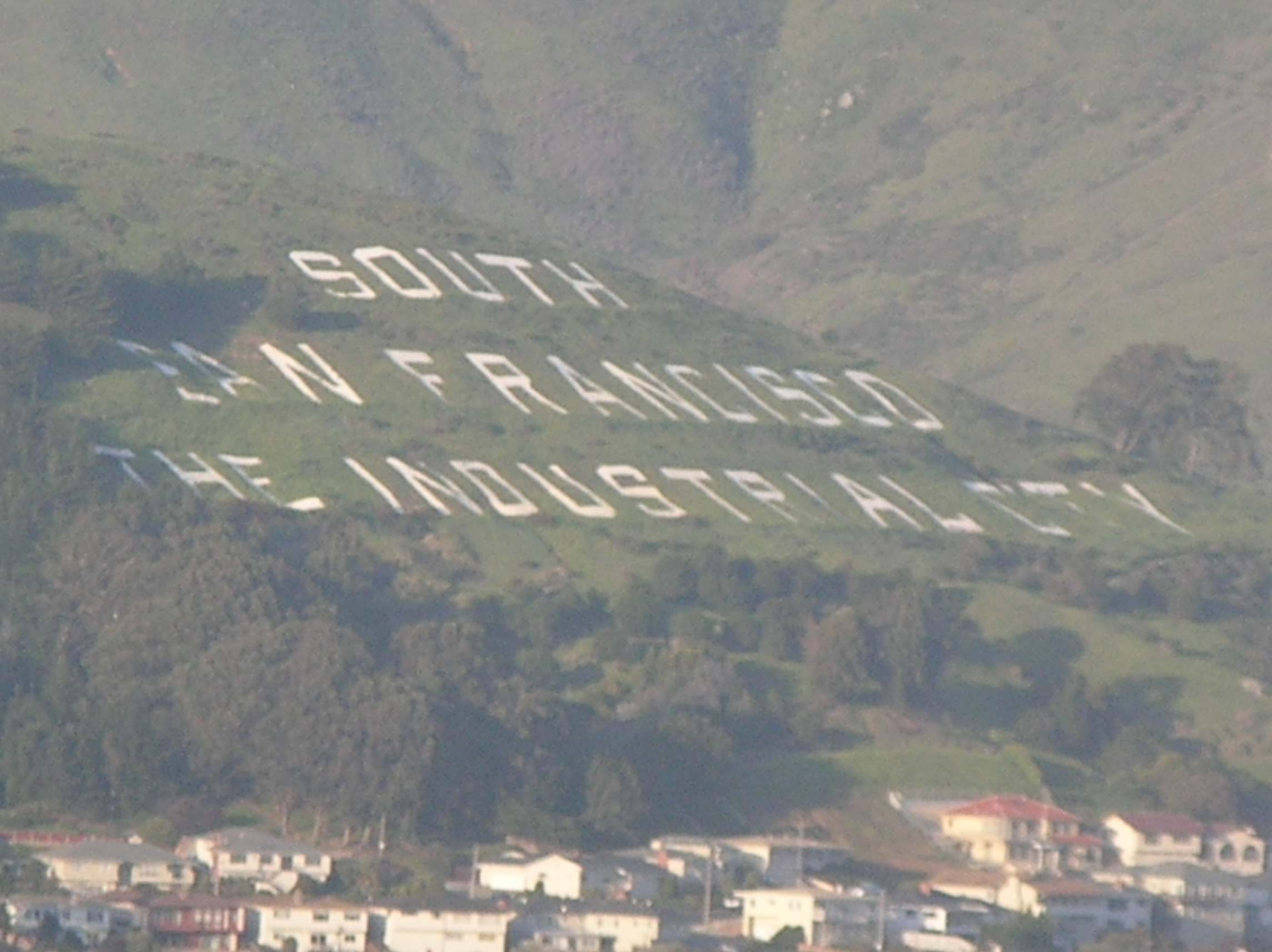
July 11, 1996 Sign Hill Park, N of Park Way
37°39′49″N 122°25′08″W / 37.663611°N 122.418889°WSouth San Francisco 44 Southern Pacific Depot 
September 1, 1978 21 E. Millbrae Ave.
37°35′56″N 122°23′05″W / 37.598889°N 122.384722°WMillbrae 45 Southern Pacific Railroad Bayshore Roundhouse March 26, 2010 Junction of Industrial Way and Bayshore Ave.
37°42′03″N 122°24′31″W / 37.700953°N 122.40855°WBrisbane Steam railroad engine roundhouse built between 1907 and 1910 46 Southern Pacific Depot 
September 20, 1984 559 El Camino Real
37°30′27″N 122°15′32″W / 37.5075°N 122.258889°WSan Carlos 47 Union Cemetery 
August 25, 1983 316 Woodside Rd.
37°28′26″N 122°13′23″W / 37.473889°N 122.223056°WRedwood City 48 US Post Main Office-San Mateo 
April 18, 1988 210 S. Ellsworth Ave.
37°34′00″N 122°19′24″W / 37.566667°N 122.323333°WSan Mateo 49 Watkins-Cartan House March 30, 1978 98 Alejandra Ave.
37°27′13″N 122°11′49″W / 37.453611°N 122.196944°WAtherton constructed around 1866 for Commodore James Watkins; located at 25 Isabella Ave. when listed on the National Register; moved to 98 Alejandra Ave. in 1998[10] 50 Woodside Store 
July 18, 1985 471 Kings Mountain Rd.
37°25′49″N 122°16′34″W / 37.430278°N 122.276111°WWoodside See also
- National Register of Historic Places listings in California
- List of National Historic Landmarks in California
References
- ^ The latitude and longitude information provided in this table was derived originally from the National Register Information System, which has been found to be fairly accurate for about 99% of listings. For about 1% of NRIS original coordinates, experience has shown that one or both coordinates are typos or otherwise extremely far off; some corrections may have been made. A more subtle problem causes many locations to be off by up to 150 yards, depending on location in the country: most NRIS coordinates were derived from tracing out latitude and longitudes off of USGS topographical quadrant maps created under the North American Datum of 1927, which differs from the current, highly accurate WGS84 GPS system used by Google maps. Chicago is about right, but NRIS longitudes in Washington are higher by about 4.5 seconds, and are lower by about 2.0 seconds in Maine. Latitudes differ by about 1.0 second in Florida. Some locations in this table may have been corrected to current GPS standards.
- ^ "National Register of Historic Places: Weekly List Actions". National Park Service, United States Department of the Interior. Retrieved on November 10, 2011.
- ^ Numbers represent an ordering by significant words. Various colorings, defined here, differentiate National Historic Landmark sites and National Register of Historic Places Districts from other NRHP buildings, structures, sites or objects.
- ^ "National Register Information System". National Register of Historic Places. National Park Service. . http://nrhp.focus.nps.gov/natreg/docs/All_Data.html.
- ^ "Filoli History". Woodside, California. http://www.filoli.org/explore-filoli/history/. Retrieved September 19, 2011.
- ^ "De Sabla, Eugene J., Jr., Teahouse and Tea Garden". National Park Service. http://www.nps.gov/nr/feature/asia/2010/sabla_tea_house.htm. Retrieved September 23, 2011.
- ^ Knoerle, Jane (January 6, 1999). "The Fleishhacker estate in Woodside is featured in "Greene & Greene: Masterworks," a new book on the famous architects from the Arts and Crafts era". The Almanac (Menlo Park, California). http://www.almanacnews.com/morgue/1999/1999_01_06.fleischh.html. Retrieved September 19, 2011.
- ^ "The History of Woodside". Woodside, California: Town of Woodside. http://www.woodsidetown.org/history.html. Retrieved September 19, 2011.
- ^ The address of this listing in the NRIS database is 220 Grand Ave., but it should be 220 Linden Ave. (at Grand Ave.)
- ^ Knoerle, Jane (October 21, 1998). "Historic house moves to new Atherton site". The Almanac (Menlo Park, California). http://www.almanacnews.com/morgue/1998/1998_10_21.cartan.html. Retrieved September 19, 2011.
External links
U.S. National Register of Historic Places Topics Lists by states Alabama • Alaska • Arizona • Arkansas • California • Colorado • Connecticut • Delaware • Florida • Georgia • Hawaii • Idaho • Illinois • Indiana • Iowa • Kansas • Kentucky • Louisiana • Maine • Maryland • Massachusetts • Michigan • Minnesota • Mississippi • Missouri • Montana • Nebraska • Nevada • New Hampshire • New Jersey • New Mexico • New York • North Carolina • North Dakota • Ohio • Oklahoma • Oregon • Pennsylvania • Rhode Island • South Carolina • South Dakota • Tennessee • Texas • Utah • Vermont • Virginia • Washington • West Virginia • Wisconsin • WyomingLists by territories Lists by associated states Other Municipalities and communities of San Mateo County, California Cities and towns Atherton | Belmont | Brisbane | Burlingame | Colma | Daly City | East Palo Alto | Foster City | Half Moon Bay | Hillsborough | Menlo Park | Millbrae | Pacifica | Portola Valley | Redwood City | San Bruno | San Carlos | San Mateo | South San Francisco | Woodside
CDPs Unincorporated
communitiesGhost towns Categories:- History of San Mateo County, California
- San Mateo County, California
- National Register of Historic Places in the San Francisco Bay Area
- National Register of Historic Places in California by county
- Lists of National Register of Historic Places in California
-


Wikimedia Foundation. 2010.