- National Register of Historic Places listings in Santa Barbara County, California
-
This list includes properties and districts listed on the National Register of Historic Places in Santa Barbara County, California. Click the "Map of all coordinates" link to the right to view a Google map of all properties and districts with latitude and longitude coordinates in the table below.[1]
-
- This National Park Service list is complete through NPS recent listings posted November 10, 2011.[2]
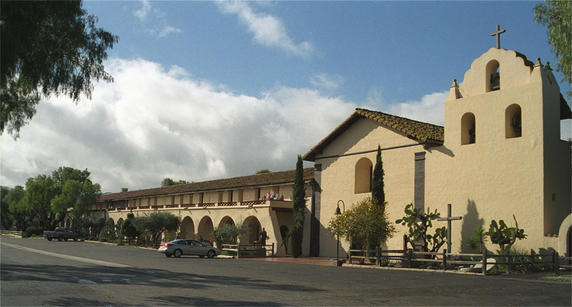
[3] Landmark name[4] Image Date listed Location City or Town Summary 1 Acacia Lodge July 9, 1997 109 Miramar Ave.
34°25′23″N 119°37′46″W / 34.42306°N 119.62944°WSanta Barbara 2 Andalucia Building December 22, 1999 316-324 State St.
34°24′57″N 119°41′33″W / 34.41583°N 119.6925°WSanta Barbara 3 Campbell No. 2 Archeological Site January 25, 1993 Address Restricted Goleta 4 Eastern Sierra Madre Ridge Archeological District December 19, 1978 Address Restricted New Cuyama 5 El Paseo and Casa de la Guerra 

February 2, 1977 808-818 State St., 813-819 Anacapa St., and 9-25 E. de la Guerra St.
34°25′14″N 119°41′54″W / 34.42056°N 119.69833°WSanta Barbara 6 Faith Mission January 11, 1982 409 State St.
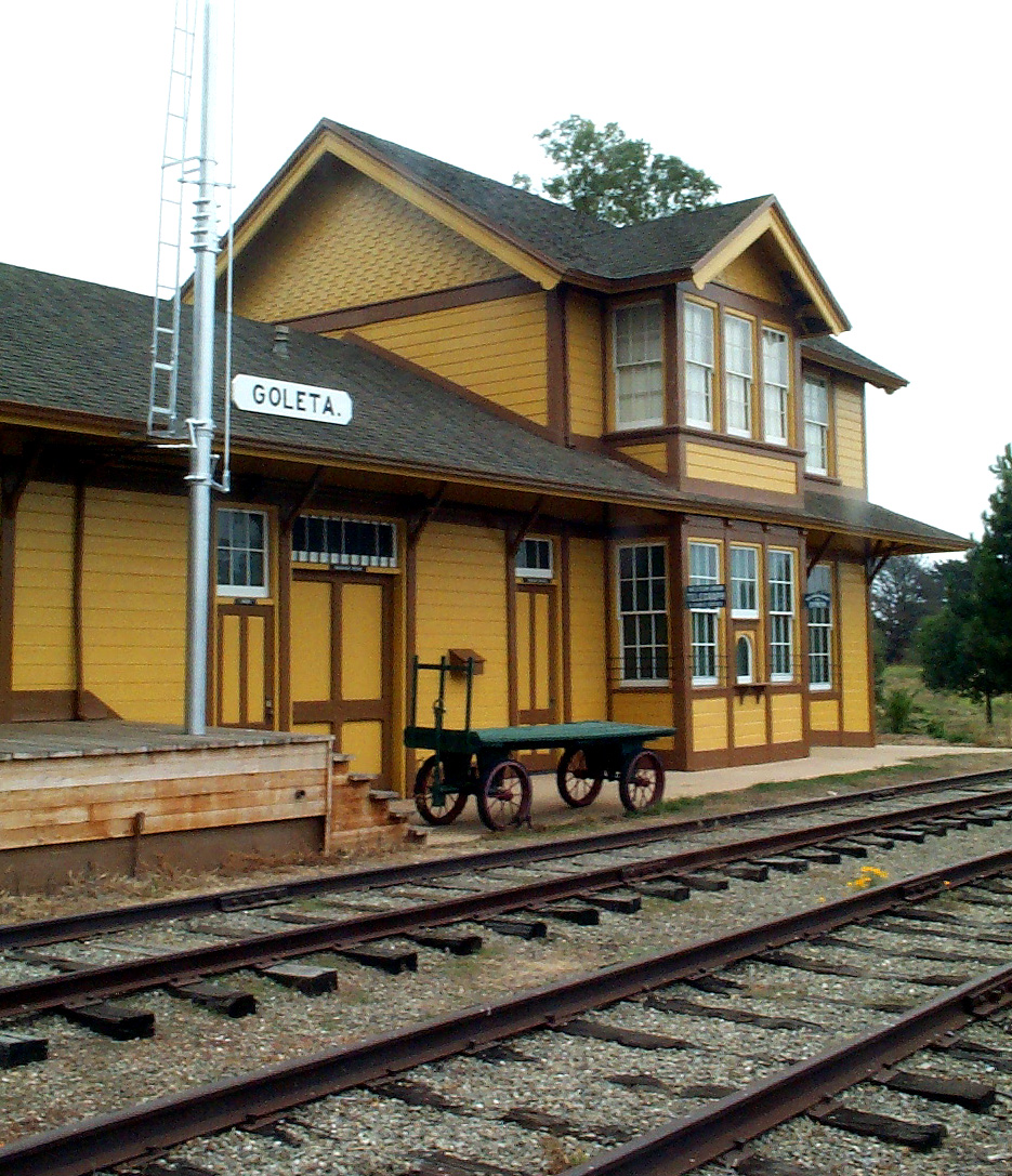
34°24′57″N 119°41′39″W / 34.41583°N 119.69417°WSanta Barbara Designed by Peter J. Barber 7 Goleta Depot 
January 18, 2002 300 N. Los Carneros Rd.
34°26′34″N 119°51′6″W / 34.44278°N 119.85167°WGoleta 8 Rafael Gonzalez House April 15, 1970 835 Laguna St.
34°25′28″N 119°41′42″W / 34.42444°N 119.695°WSanta Barbara A National Historic Landmark 9 Hammond's Estate Site May 19, 1978 Address Restricted Santa Barbara 10 Allan Herschell 3-Abreast Carousel 
April 13, 2000 223 E. Cabrillo Blvd.
34°24′54″N 119°41′5″W / 34.415°N 119.68472°WSanta Barbara 11 Hill-Carrillo Adobe January 14, 1986 11 E. Carrillo St.
34°25′20″N 119°42′3″W / 34.42222°N 119.70083°WSanta Barbara 12 Thomas Hope House December 1, 1978 399 Nogal Dr.
34°26′4″N 119°46′14″W / 34.43444°N 119.77056°WSanta Barbara Designed by Peter J. Barber 13 Janssens-Orella-Birk Building July 16, 1987 1029-1031 State St.
34°24′45″N 119°42′7″W / 34.4125°N 119.70194°WSanta Barbara 14 La Purisima Mission 
April 15, 1970 4 mi. E of Lompoc, near jct. of CA 1 and 150
34°40′31.16″N 120°25′18.52″W / 34.6753222°N 120.4218111°WLompoc A National Historic Landmark 15 Lompoc Public Library December 10, 1990 200 S. H St.
34°38′13″N 120°27′24″W / 34.63694°N 120.45667°WLompoc 16 Los Alamos Ranch House April 15, 1970 3 mi. W of Los Alamos on old U.S. 101 Los Alamos A National Historic Landmark 17 Los Banos del Mar December 24, 1992 401 Shoreline Dr.
34°24′28″N 119°41′33″W / 34.40778°N 119.6925°WSanta Barbara 18 Madulce Guard Station and Site December 11, 1979 40 mi. N. of Santa Barbara
34°42′11″N 119°34′42″W / 34.70306°N 119.57833°WSanta Barbara 19 Minerva Club of Santa Maria September 20, 1984 127 W. Boone St.
34°56′51″N 120°26′9″W / 34.9475°N 120.43583°WSanta Maria 20 Mission de la Purisima Concepcion de Maria Santisima Site May 5, 1978 Bounded by Locust Ave., city limits, E and G Sts.
34°37′55″N 120°27′23″W / 34.63194°N 120.45639°WLompoc 21 Mission Santa Inés 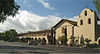
March 8, 1999 E side of Solvang, S of CA 246
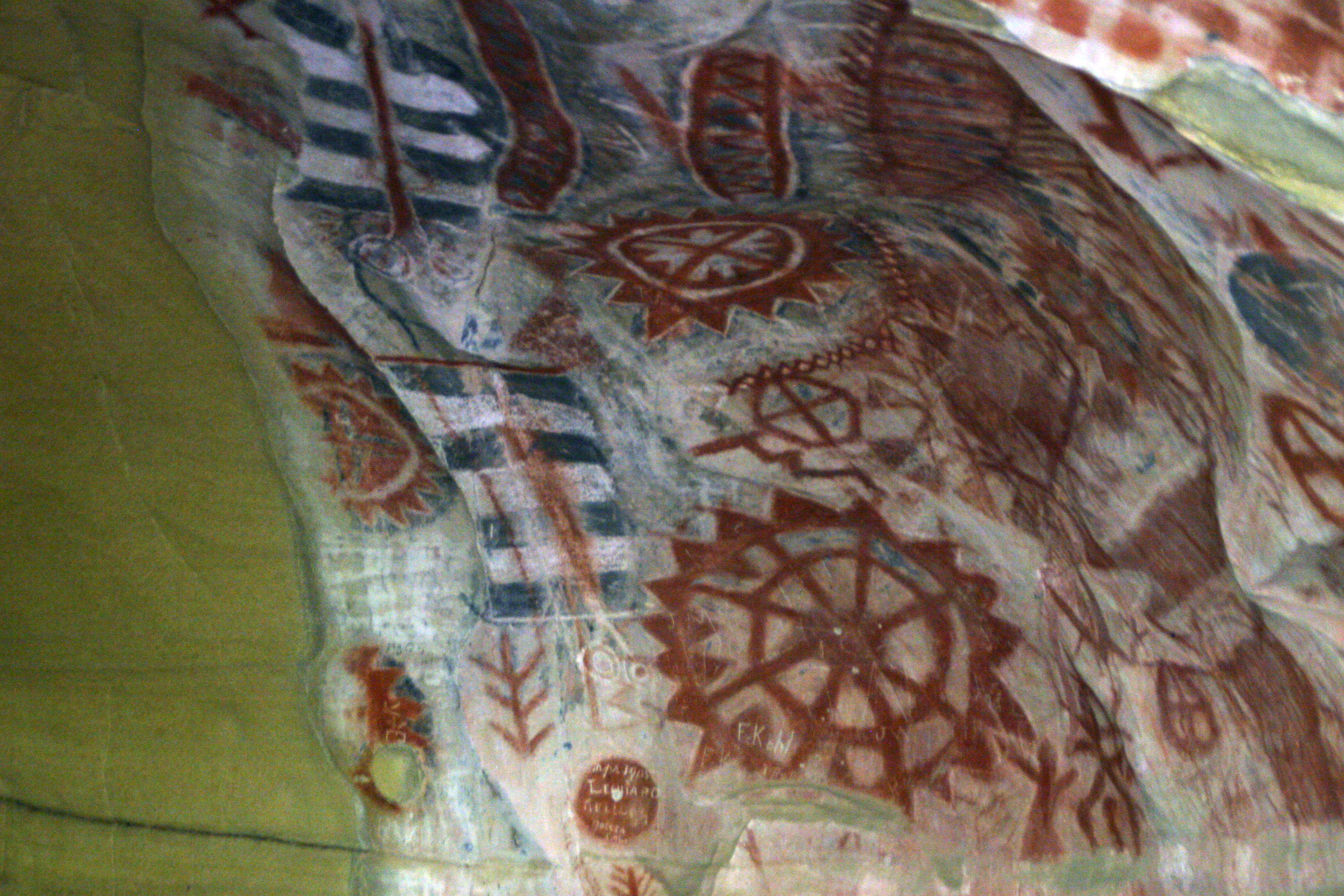
34°35′37″N 120°7′51″W / 34.59361°N 120.13083°WSolvang A National Historic Landmark District 22 Painted Cave 
December 5, 1972 Address Restricted Santa Barbara 23 Point Conception Light Station 
February 25, 1981 U.S. Coast Guard Light Station
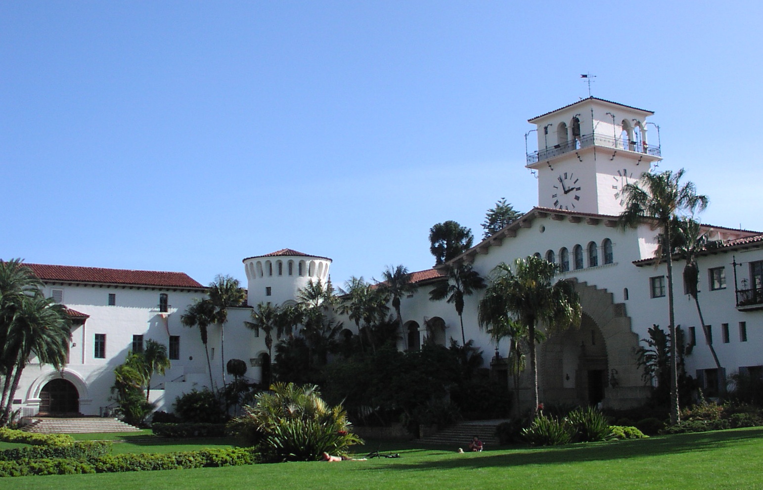
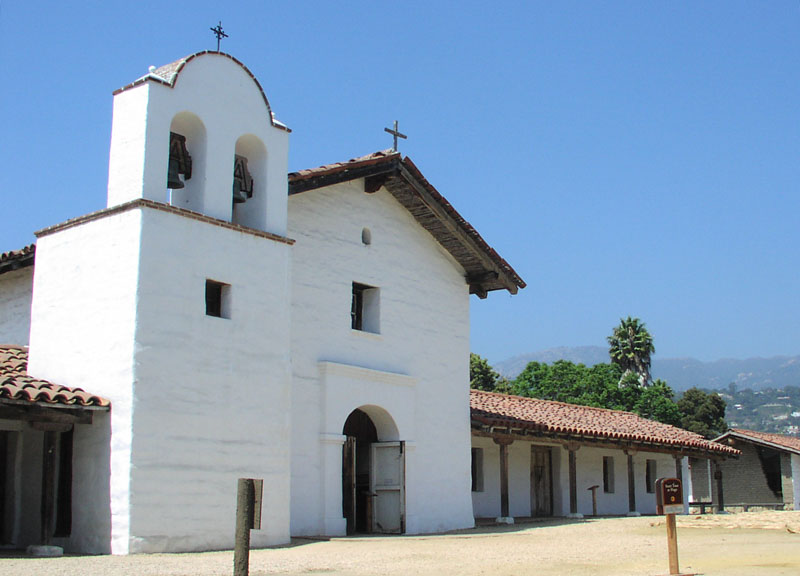
34°27′2″N 120°28′7″W / 34.45056°N 120.46861°WSanta Barbara 24 Point Sal Ataje November 21, 2002 Address Restricted Point Sal Highlands 25 San Marcos Rancho April 26, 1979 Address Restricted Santa Barbara 26 San Miguel Island Archeological District September 12, 1979 Address Restricted Santa Barbara 27 Santa Barbara County Courthouse 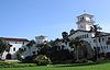
January 23, 1981 1100 Anacapa St.
34°25′30″N 119°41′24″W / 34.425°N 119.69°WSanta Barbara A National Historic Landmark 28 Santa Barbara Island Archeological District September 12, 1979 Address Restricted Santa Barbara 29 Santa Barbara Mission 
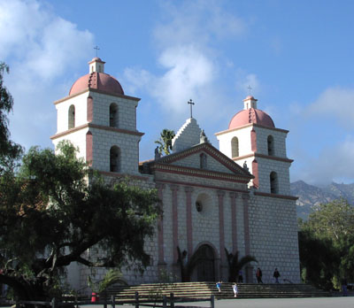
October 15, 1966 2201 Laguna St.
34°26′16.09″N 119°42′50.49″W / 34.4378028°N 119.714025°WSanta Barbara A National Historic Landmark 30 Santa Barbara Presidio 
November 26, 1973 Roughly bounded by Carrillo, Garden, De la Guerra and Anacapa Sts.
34°25′21″N 119°41′50″W / 34.4225°N 119.69722°WSanta Barbara 31 Santa Cruz Island Archeological District January 30, 1980 Address Restricted Santa Barbara 32 Joseph and Lucy Foster Sexton House February 5, 1992 5490 Hollister Ave.
34°26′9″N 119°48′55″W / 34.43583°N 119.81528°WSanta Barbara Italianate, designed by Peter J. Barber 33 Southern Pacific Train Depot 
August 2, 2006 209 State St.
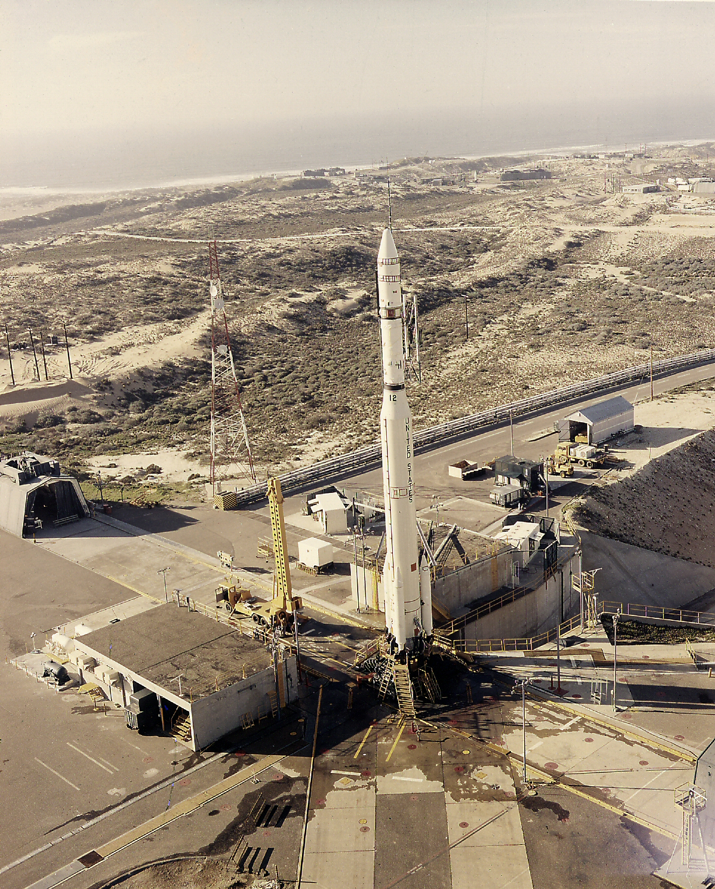
34°24′49″N 119°41′30″W / 34.41361°N 119.69167°WSanta Barbara 34 Space Launch Complex 10 
June 23, 1986 Vandenberg Air Force Base
34°45′55″N 120°37′20″W / 34.76528°N 120.62222°WLompoc A National Historic Landmark 35 SS Yankee Blade May 16, 1991 Address Restricted Lompoc 36 St. Vincent Orphanage and School Building June 2, 1982 925 De La Vina St.
34°25′8″N 119°42′11″W / 34.41889°N 119.70306°WSanta Barbara 37 Steedman Estate January 29, 1987 1387 E. Valley Rd.
34°26′7″N 119°38′8″W / 34.43528°N 119.63556°WMontecito National Historic Landmark designation January 16, 2009 38 Stow House 
September 28, 2000 304 N. Los Carneros Rd.
34°26′34″N 119°51′3″W / 34.44278°N 119.85083°WGoleta 39 US Post Office-Santa Barbara Main 
January 11, 1985 836 Anacapa St.
34°25′22″N 119°41′57″W / 34.42278°N 119.69917°WSanta Barbara 40 Val Verde March 31, 1995 2549 Sycamore Canyon Rd.
34°26′24″N 119°38′55″W / 34.44°N 119.64861°WSanta Barbara 41 Virginia Hotel March 31, 2000 17 and 23 W. Haley St.
34°24′58″N 119°41′41″W / 34.41611°N 119.69472°WSanta Barbara See also
- National Register of Historic Places listings in California
- List of National Historic Landmarks in California
References
- ^ The latitude and longitude information provided in this table was derived originally from the National Register Information System, which has been found to be fairly accurate for about 99% of listings. For about 1% of NRIS original coordinates, experience has shown that one or both coordinates are typos or otherwise extremely far off; some corrections may have been made. A more subtle problem causes many locations to be off by up to 150 yards, depending on location in the country: most NRIS coordinates were derived from tracing out latitude and longitudes off of USGS topographical quadrant maps created under the North American Datum of 1927, which differs from the current, highly accurate WGS84 GPS system used by Google maps. Chicago is about right, but NRIS longitudes in Washington are higher by about 4.5 seconds, and are lower by about 2.0 seconds in Maine. Latitudes differ by about 1.0 second in Florida. Some locations in this table may have been corrected to current GPS standards.
- ^ "National Register of Historic Places: Weekly List Actions". National Park Service, United States Department of the Interior. Retrieved on November 10, 2011.
- ^ Numbers represent an ordering by significant words. Various colorings, defined here, differentiate National Historic Landmark sites and National Register of Historic Places Districts from other NRHP buildings, structures, sites or objects.
- ^ "National Register Information System". National Register of Historic Places. National Park Service. 2008-04-24. http://nrhp.focus.nps.gov/natreg/docs/All_Data.html.
U.S. National Register of Historic Places Topics Lists by states Alabama • Alaska • Arizona • Arkansas • California • Colorado • Connecticut • Delaware • Florida • Georgia • Hawaii • Idaho • Illinois • Indiana • Iowa • Kansas • Kentucky • Louisiana • Maine • Maryland • Massachusetts • Michigan • Minnesota • Mississippi • Missouri • Montana • Nebraska • Nevada • New Hampshire • New Jersey • New Mexico • New York • North Carolina • North Dakota • Ohio • Oklahoma • Oregon • Pennsylvania • Rhode Island • South Carolina • South Dakota • Tennessee • Texas • Utah • Vermont • Virginia • Washington • West Virginia • Wisconsin • WyomingLists by territories Lists by associated states Other Municipalities and communities of Santa Barbara County, California Cities Buellton | Carpinteria | Goleta | Guadalupe | Lompoc | Santa Barbara | Santa Maria | Solvang
CDPs Ballard | Casmalia | Cuyama | Garey | Isla Vista | Los Alamos | Los Olivos | Mission Canyon | Mission Hills | Montecito | New Cuyama | Orcutt | Santa Ynez | Sisquoc | Summerland | Toro Canyon | Vandenberg AFB | Vandenberg Village
Unincorporated
communitiesGaviota | Hope Ranch | Las Cruces | Painted Cave | Ventucopa
Ghost town Santa Rita
Categories:- History of Santa Barbara County, California
- Santa Barbara County, California
- Buildings and structures in Santa Barbara County, California
- National Register of Historic Places in California by county
- Lists of National Register of Historic Places in California
-


Wikimedia Foundation. 2010.